Africa Surveyors March-April issue 2024 digital
Africa Surveyors is Africa’s premier source of Surveying, Mapping and Geospatial news and an envoy of surveying products/service for the Construction, Maritime, Onshore & Offshore energy and exploration, Engineering, Oil and Gas, Agricultural and Mining sectors on new solution based trends and technology for the African market.
Africa Surveyors is Africa’s premier source of Surveying, Mapping and Geospatial news and an envoy of surveying products/service for the Construction, Maritime, Onshore & Offshore energy and exploration, Engineering, Oil and Gas, Agricultural and Mining sectors on new solution based trends and technology for the African market.

You also want an ePaper? Increase the reach of your titles
YUMPU automatically turns print PDFs into web optimized ePapers that Google loves.
<strong>March</strong>-<strong>April</strong> <strong>2024</strong> Volume 6 <strong>issue</strong> no. 32<br />
<strong>Africa</strong> <strong>Surveyors</strong><br />
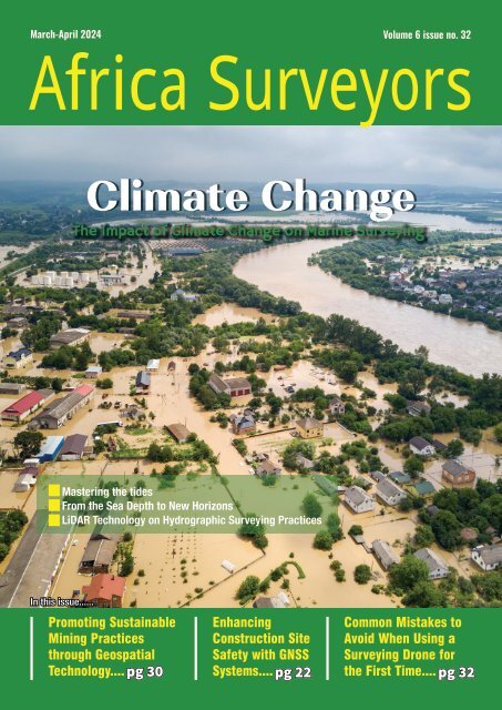
Climate Change<br />
The Impact of Climate Change on Marine Surveying<br />
Mastering the tides<br />
From the Sea Depth to New Horizons<br />
LiDAR Technology on Hydrographic Surveying Practices<br />
In this <strong>issue</strong>......<br />
Promoting Sustainable<br />
Mining Practices<br />
through Geospatial<br />
Technology.... pg 30<br />
Enhancing<br />
Construction Site<br />
Safety with GNSS<br />
Systems....<br />
Common Mistakes to<br />
Avoid When Using a<br />
Surveying Drone for<br />
the First Time.... pg 32<br />
pg 30 pg 22 pg 32
AVAILABLE NOW<br />
Survey | Spill Response | Search-and-Rescue | Fire | Security | Offshore Wind | Aquaculture<br />
Sea Machines’ innovation and advanced technology gives vessel owners an operational advantage. Contact us to<br />
schedule a live demonstration and learn how Sea Machines can solve your most persistent challenges on the water.<br />
SEA MACHINES<br />
Request a live demo at<br />
sea-machines.com/contact
Current Issue<br />
In this <strong>issue</strong>, we look<br />
at the Climate Change<br />
and how it affects<br />
Marine Surveying &<br />
much more...enjoy the<br />
<strong>issue</strong>!<br />
Contents<br />
16<br />
22<br />
CONTENTS<br />
REGULARS<br />
News Briefs 4<br />
Events 10<br />
32<br />
Innovation 12<br />
Opinion 18<br />
Safety Tips 36<br />
Director<br />
Augustine M. Rang’ondi<br />
Senior Editor<br />
& Marketing Lead<br />
Dorcas Kang’ereha<br />
Writers<br />
Harriet Mkhaye<br />
Irene Joseph<br />
Claudia Mangi<br />
COVER STORY<br />
Climate Change: The Impact of Climate Change on Marine<br />
Surveying<br />
FEATURES<br />
The Future of Ocean Exploration: Advancements in<br />
Autonomous Underwater Vehicles<br />
18<br />
20<br />
Sales Executives<br />
East <strong>Africa</strong><br />
Lydia Kamonya<br />
Caiser Momanyi<br />
John Midecha<br />
Sheilah Ing’ayitsa<br />
South <strong>Africa</strong><br />
Paul Nyakeri<br />
Lisa Brown<br />
Sean Masangwanyi<br />
Thembisa Ndlovu<br />
Nigeria<br />
Imelda Njomboro<br />
Uche Maxwel<br />
Published and<br />
Designed By:<br />
GNSS Systems: Enhancing Construction Site Safety<br />
LiDAR Technology: The Transformative Impact on<br />
Hydrographic Surveying Practices<br />
Underwater Drones: From the Sea Depth to New Horizons<br />
Mastering the Tides as a Hydrographer<br />
Digital Twins: Building Resilient Cities with the Help of<br />
Infrastructure Digital Twins<br />
Drones: Common Mistakes to Avoid When Using a<br />
Surveying Drone for the First Time<br />
Josem Trust House,<br />
3rd Floor, Bunyala<br />
Road,<br />
Upper Hill.<br />
P.O. Box 52248-00100,<br />
Nairobi, Kenya.<br />
ADVERTISER’S INDEX<br />
Sea Machines....................................................................................................................IFC<br />
Caroni.................................................................................................................................IBC<br />
Navvis...............................................................................................................................OBC<br />
Aptella.............................................................................................................................pg 13<br />
BricsCAD.......................................................................................................................pg 25<br />
Altavec............................................................................................................................pg 29<br />
Forssea Robotics.........................................................................................................pg 39<br />
Imagenex.......................................................................................................................pg 38<br />
MacArtney.....................................................................................................................pg 42<br />
40<br />
Contact us:<br />
Tel: +254 113 194 740<br />
Email: info@africasurveyorsonline.com<br />
Web: https://africasurveyorsonline.com<br />
The Editor accepts letter and manuscripts for publication from readers all over the world. Include your name and address as a sign of good faith although you may<br />
request your name to be withheld from publication. We can reserve the right to edit any material submitted. Send your letters to: info@africaautomotivenews.com<br />
Disclaimer:<br />
Nailex <strong>Africa</strong> Publishing Ltd makes every effort to ensure the accuracy of the contents of its publications, but no warranty is made to such accuracy<br />
and no responsibility will be borne by the publisher for the consequences of actions based on information so published. Further, opinions expressed<br />
on interviews are not necessarily shared by Nailex <strong>Africa</strong> Publishing Ltd.<br />
www.africasurveyorsonline.com<br />
<strong>March</strong>-<strong>April</strong> <strong>issue</strong> l <strong>2024</strong> 3
NEWS BRIEFS<br />
Exciting Discoveries in Tanzania’s Ruvuma PSA<br />
A<br />
recent data interpretation operation<br />
by ARA Petroleum Tanzania has<br />
revealed some exciting news about<br />
the Ruvuma PSA. A 3D survey conducted by<br />
Aminex has shown a significant increase in<br />
resource potential in the wider license area.<br />
This survey has uncovered 338 sq km of new<br />
data, leading to some promising results.<br />
Through seismic inversion geomodeling with<br />
Ikon Geoscience, there has been a notable<br />
improvement in the in-place volumetrics for<br />
the Ntorya gas discovery. It is estimated that<br />
around 3.45 trillion cu/ft of gas initially in<br />
place (GIIP) could be found in the reservoir<br />
sandstones of the Ntorya-1 (NT1) and<br />
Ntorya-2 (NT-2) discovery wells.<br />
Potential Future Discoveries<br />
The new 3D seismic images suggest the<br />
presence of even more gas-charged reservoir<br />
sandstones, potentially leading to additional<br />
gas volumes. There is also hope for the<br />
discovery of an as yet undrilled shallower<br />
sand unit (Unit 3) to be tested by the<br />
upcoming Chikumbi-1 (CH-1) appraisal well.<br />
Exploration Potential<br />
For the first time, the 3D dataset has<br />
uncovered significant undrilled exploration<br />
potential within the broader license area.<br />
This opens up new possibilities for future<br />
discoveries.<br />
Excitement from Executives<br />
Charles Santos, executive chairman of<br />
Aminex, expressed his excitement about<br />
the results, stating that the Ntorya gas<br />
field development is reaching important<br />
milestones. The new 3D seismic dataset has<br />
provided detailed mapping of the Ntorya<br />
gas discovery, refined volumetric estimates,<br />
and identified future drilling targets. The<br />
potential gas volumes identified in other<br />
untested structures within the license area<br />
are particularly exciting.<br />
Leveraging AI and Machine Learning to modernize<br />
the Land Sector<br />
The Ministry of Lands, Housing and<br />
Urban Development is keen to using<br />
Artificial Intelligence (AI) and Machine<br />
Learning (ML) to improve how they study land<br />
use and classify land cover. Cabinet Secretary<br />
(CS) Alice Wahome shared this during the<br />
Pre-AGM conference of the Institution<br />
of <strong>Surveyors</strong> of Kenya (ISK) in Mombasa.<br />
The two-day conference under the theme:<br />
“Harnessing Artificial Intelligence (AI) for an<br />
Environmental, Social, and Governance (ESG)<br />
compliant Surveying” brings together Land<br />
and Built Sector Professionals from the public,<br />
private sector and academia. CS Wahome<br />
mentioned that with more people and cities<br />
growing, land and water are getting stressed.<br />
Using AI and ML can help manage land better<br />
since it‘s limited.<br />
The shift towards incorporating AI and<br />
machine learning in surveying has allowed for<br />
more efficient data collection, analysis, and<br />
interpretation. Leveraging these technologies,<br />
surveyors can now process large amounts of<br />
data quickly and accurately, leading to more<br />
A 3D survey conducted by Aminex has shown a significant<br />
increase in resource potential in the wider license area. |<br />
Image: Courtesy<br />
Ministry of Lands, Housing and Urban Development, Cabinet<br />
Secretary (CS) Alice Wahome commits to using technology to<br />
modernize the Land Sector. |Image: courtesy<br />
precise results and faster project completion<br />
times. Additionally, the use of AI in surveying<br />
has opened up new possibilities for<br />
automation and optimization of workflows,<br />
ultimately improving the overall quality of<br />
surveying services. As AI continues to advance<br />
and become more integrated into the industry,<br />
surveyors who embrace these technologies<br />
will be better positioned to meet the evolving<br />
demands of their clients and stay ahead of<br />
the competition.<br />
Utilizing drones and other flying machines,<br />
the ArdhiSasa platform can provide realtime<br />
data on land usage, boundaries, and<br />
ownership.<br />
Shell Petroleum<br />
Development Company<br />
Deploys Uncrewed<br />
Surface Vessel for<br />
Pipeline Survey in Nigeria<br />
Uncrewed Surface Vessel. | Image: courtesy for illustration<br />
purposes<br />
In a groundbreaking move, the Shell<br />
Petroleum Development Company<br />
of Nigeria Ltd (SPDC) has utilized an<br />
uncrewed surface vessel (USV) for a pipeline<br />
survey in Bonny, Niger Delta. This innovative<br />
approach not only saves time and money but<br />
also ensures the safety of both personnel<br />
and the environment. This mission marks the<br />
longest single operation ever undertaken by<br />
the Shell Group, lasting a total of 166 hours<br />
in the shallow waters of Nigeria.<br />
SPDC’s chief surveyor, Steve Keedwell,<br />
highlighted the advantages of using the USV<br />
for the survey. The deployment of the USV<br />
led to enhanced productivity, improved data<br />
acquisition, and a significant reduction in CO2<br />
emissions by 97%. The vehicle’s diesel-electric<br />
design played a crucial role in achieving this<br />
environmental milestone.<br />
The success of the survey was made<br />
possible through collaboration with various<br />
stakeholders, including the Nigerian<br />
Upstream Petroleum Regulatory Commission,<br />
NNPC Upstream Investment Management<br />
Services, Nigerian Content Development<br />
and Management Board, Nigerian Navy<br />
Hydrographic Office, and Nigerian Maritime<br />
Administration and Safety Agency.<br />
This partnership not only demonstrates<br />
SPDC’s commitment to supporting local<br />
businesses and developing Nigerian talent,<br />
but also highlights the importance of<br />
technology transfer and knowledge sharing<br />
in the oil and gas industry. By investing in<br />
training and empowering local operators,<br />
SPDC is not only ensuring the sustainability of<br />
its operations in Nigeria, but also contributing<br />
to the growth and development of the<br />
country’s economy.<br />
4 <strong>March</strong>-<strong>April</strong> <strong>issue</strong> l <strong>2024</strong> www.africasurveyorsonline.com
NEWS BRIEFS<br />
Topographic Surveys<br />
Commence on the<br />
Nigeria-Morocco Gas<br />
Pipeline<br />
The Nigeria-Morocco Gas Pipeline project aims to link <strong>Africa</strong><br />
and Europe in terms of energy supply. | Image: courtesy<br />
ETAFAT has officially commenced<br />
topographic surveys for the northern<br />
section of the Nigeria-Morocco Gas<br />
Pipeline project. This part of the pipeline<br />
includes Morocco, Mauritania, and Senegal.<br />
After a meeting between Morocco’s National<br />
Office of Hydrocarbons and Mines and the<br />
Nigerian National Petroleum Corporation,<br />
ETAFAT announced that the initial<br />
topographic studies for the northern portion<br />
are well underway and at an advanced stage.<br />
The Nigeria-Morocco Gas Pipeline project<br />
aims to link <strong>Africa</strong> and Europe in terms of<br />
energy supply. It will provide gas to several<br />
countries in both continents, making it the<br />
largest project of its kind in <strong>Africa</strong>. The<br />
pipeline will run along the West <strong>Africa</strong>n<br />
coast from Nigeria, passing through several<br />
countries before reaching Morocco. Once<br />
in Morocco, it will connect to the Maghreb-<br />
Europe Gas Pipeline and the European gas<br />
network.<br />
Many believe that this project will be a<br />
major milestone in <strong>Africa</strong>’s development,<br />
bringing economic gains and promoting<br />
continental integration. King Mohammed VI<br />
of Morocco highlighted the importance of the<br />
project during the 47th anniversary of the<br />
Green <strong>March</strong>. The King emphasized that the<br />
Nigeria-Morocco Gas Pipeline Project is more<br />
than just a bilateral project. He sees it as a<br />
strategic initiative that will benefit all of West<br />
<strong>Africa</strong>, a region with over 440 million people.<br />
Construction work on the Nigeria-Morocco<br />
Gas Pipeline project is set to begin this year,<br />
according to Nigerian Minister of State for<br />
Petroleum Resources, Ekperekpe Ekpo. To<br />
ensure the project’s success, four memoranda<br />
of understanding were signed in June 2023<br />
for the $25 billion project.<br />
www.africasurveyorsonline.com<br />
PGS releases first 3D data from Egypt deepwaters<br />
PGS has announced that the early-out<br />
data for the EGY23 Merneith & Luxor<br />
MultiClient programme is now ready<br />
for exploration enthusiasts to dive into! This<br />
data provides the very first 3D seismic data<br />
over the deepwater area between the Nile<br />
delta and the Herodotus Basin.<br />
Using Ramform vessels and GeoStreamer<br />
broadband technology, the 6,175 sq km<br />
EGY23 Merneith & Luxor survey was made<br />
possible. PGS teamed up with the Egyptian<br />
Natural Gas Holding Company (EGAS) to<br />
make this happen.<br />
The data collected includes both low and<br />
high-frequency information, which can help<br />
experts interpret structures and analyze rock<br />
properties in a whole new way. This could<br />
lead to some exciting discoveries.<br />
This survey delved into an underexplored<br />
and unlicensed deepwater area, providing<br />
a significant upgrade from the 2D data that<br />
was previously available. It’s like unlocking a<br />
whole new world of possibilities.<br />
One interesting find is a Messinian evaporite<br />
layer of varying thickness that stretches<br />
across most of the area. The survey is<br />
connected to the Kiwi-1 well, a rare find in<br />
this deepwater region. Experts believe that<br />
the primary targets will be presalt Oligo-<br />
Miocene structures with clastic reservoirs.<br />
Sounds like there’s a lot to uncover.<br />
So, if you’re into exploration and discovery,<br />
this early-out data from the EGY23 Merneith<br />
& Luxor MultiClient programme is definitely<br />
something to get excited about! Who knows<br />
what secrets it might reveal?<br />
NIQS Emphasizes the importance of<br />
Quantity <strong>Surveyors</strong><br />
President of the Nigeria Institute of<br />
Quantity <strong>Surveyors</strong> (NIQS), Mr. Kene<br />
Nzekwe, recently highlighted the<br />
crucial role that quantity surveyors play<br />
in carrying out the federal government’s<br />
infrastructure renewal plans. He expressed<br />
gratitude for the support from sponsors and<br />
partners, recognizing that their contributions<br />
directly aid the government in addressing<br />
the country’s infrastructure challenges and<br />
unlocking its economic potential.<br />
In a country like Nigeria, where infrastructure<br />
development is vital for economic growth and<br />
societal well-being, quantity surveyors are<br />
essential. They act as guardians of efficiency,<br />
ensuring that projects are completed on time,<br />
within budget, and to the highest quality<br />
standards.<br />
Nzekwe acknowledged the generous support<br />
from sponsors and partners, which enables<br />
the NIQS to organize seminars, workshops,<br />
and training programs for its members.<br />
This support also fuels research initiatives<br />
the very first 3D seismic data over the deepwater area<br />
between the Nile delta and the Herodotus Basin. | Image:<br />
courtesy<br />
NIQS Emphasizes the importance of Quantity <strong>Surveyors</strong>. |<br />
Image: NIQS<br />
that drive innovation and best practices in<br />
quantity surveying, leading to more efficient<br />
and sustainable infrastructure projects.<br />
Additionally, it allows the institute to engage<br />
in activities that mentor and train the next<br />
generation of quantity surveyors.<br />
The partnership between NIQS and its<br />
sponsors goes beyond financial backing. It<br />
signifies a shared commitment to advancing<br />
the profession and developing the nation. This<br />
collaboration is crucial for implementing the<br />
Renewed Hope Infrastructure Development<br />
Fund established by the President, which aims<br />
to drive infrastructure development in key<br />
sectors such as agriculture, transportation,<br />
energy, and healthcare.<br />
<strong>March</strong>-<strong>April</strong> <strong>issue</strong> l <strong>2024</strong> 5
INTERNATIONAL<br />
Unique Group Enhancing Global Engineering Capabilities<br />
Unique Group, a major player in subsea<br />
technologies and engineering, has<br />
recently acquired Subsea Innovation,<br />
a top subsea technology and equipment<br />
manufacturer. This strategic move is a big<br />
step forward for Unique Group, expanding<br />
its global engineering capabilities and<br />
strengthening its dedication to engineering<br />
excellence and technological advancement.<br />
Headquartered in the United Arab Emirates,<br />
has been a leader in subsea technologies for<br />
more than 30 years, with over 600 employees<br />
in 18 locations worldwide. This acquisition<br />
establishes the UK as a central engineering<br />
hub for Unique Group, complementing its<br />
manufacturing sites in South <strong>Africa</strong>, the<br />
Middle East, and the Isle of Wight in the UK.<br />
Subsea Innovation Limited, based in<br />
Darlington, UK, and previously part of<br />
Tekmar Group plc, brings over 40 years<br />
of experience to the table. Specializing<br />
in offshore deck equipment, engineering<br />
consulting, emergency pipeline repair<br />
Unique Group Enhancing Global Engineering Capabilities and strengthening its dedication to engineering excellence and<br />
technological advancement. | Image: courtesy<br />
systems, and customized solutions for subsea<br />
and renewable applications, the company<br />
has completed more than 450 complex<br />
engineering projects globally. This acquisition<br />
aligns perfectly with Unique Group’s offerings,<br />
enhancing its focus on technology growth and<br />
ability to provide comprehensive solutions for<br />
clients.<br />
Sahil Gandhi, CEO of Unique Group,<br />
expressed his enthusiasm for the acquisition,<br />
emphasizing the company’s commitment to<br />
innovation and engineering expertise. Dave<br />
Thompson, Managing Director of Subsea<br />
Innovation, and his skilled engineering team<br />
will bring their knowledge and experience to<br />
Unique Group, with Thompson taking on the<br />
role of Group Engineering Director. Together,<br />
they aim to push the boundaries of product<br />
development and engineering excellence.<br />
Thompson shared his excitement about<br />
joining Unique Group, highlighting the<br />
potential for growth and the opportunity to<br />
redefine industry standards.<br />
OMV Petrom hires ABL for Neptun Deep Gas Field Project<br />
OMV Petrom has hired ABL, a global<br />
energy and marine consultancy, to<br />
help with the Neptun Deep Gas Field<br />
Project in the Black Sea. ABL will provide<br />
Marine Warranty Survey (MWS) services to<br />
make sure everything goes smoothly. This<br />
project is a big deal for Romania as it’s the<br />
largest natural gas project in the country’s<br />
Black Sea waters. They plan to start producing<br />
gas in 2027, which will help make sure the<br />
region has enough energy.<br />
ABL’s team in London will be in charge of<br />
reviewing, surveying, and approving all<br />
the operations for the Transportation &<br />
Installation (T&I) of important project assets.<br />
This includes building a shallow water<br />
platform, installing critical project assets<br />
under the sea, and laying a 160 km pipeline<br />
to shore.<br />
The shallow water platform project in Italy<br />
and Indonesia will require coordination<br />
and collaboration between multiple ABL<br />
offices around the world. The main office in<br />
London will oversee the project management,<br />
OMV Petrom Partners with ABL for Neptun Deep Gas Field Project in the Black Sea, Romania. | Image: courtesy<br />
ensuring that all aspects of the construction<br />
are on track and within budget. Meanwhile,<br />
the team in the Black Sea will be responsible<br />
for overseeing the on-site operations, making<br />
sure that construction is proceeding according<br />
to plan.<br />
Additionally, the teams in Indonesia will<br />
provide support and assistance as needed,<br />
leveraging their local knowledge and<br />
expertise to ensure that all regulatory<br />
requirements are met and that any logistical<br />
challenges are addressed promptly. By<br />
working together across different regions,<br />
ABL can leverage their global resources<br />
and capabilities to successfully deliver this<br />
complex project on time and within budget.<br />
Sergio Leone, the MWS Project Manager, is<br />
excited about the project. He says it will not<br />
only help Romania but also support Europe’s<br />
energy security in the long run. ABL is proud<br />
to be part of this important project and is<br />
committed to making sure it is a success.<br />
6 <strong>March</strong>-<strong>April</strong> <strong>issue</strong> l <strong>2024</strong> www.africasurveyorsonline.com
INTERNATIONAL<br />
Exail enhances offshore operations with Octans AHRS advanced technology<br />
Exail, has secured a contract with<br />
Bourbon, to supply several units of<br />
Exail Octans Attitude and Heading<br />
Reference Systems (AHRS) for integration<br />
into Bourbon Subsea Services subsidiary’s<br />
fleet. These units will be installed on multiple<br />
Bourbon Evolution 800 Series multi-purpose<br />
support vessels (MPSVs) dedicated to subsea<br />
operations at depths down to 3,000 meters.<br />
IMO-HSC certified, the Octans AHRS will<br />
enhance Bourbon vessels’ efficiency in<br />
installation, maintenance, and repair tasks for<br />
the oil and gas, and offshore wind industries.<br />
Providing highly accurate measurements<br />
for roll, pitch, and heave, Octans will serve<br />
as a survey-grade surface gyrocompass and<br />
motion sensor, seamlessly integrated into the<br />
vessels’ Class 3 dynamic positioning (DP3)<br />
system. This integration will ensure precise<br />
positioning and stabilization over underwater<br />
structures, ensuring the safe deployment of<br />
cranes, Remotely Operated Vehicles (ROVs),<br />
and supporting efficient survey and saturation<br />
diving operations.<br />
Exail enhances offshore operations with Octans AHRS advanced technology | Image: Exail<br />
“With the deployment of ROVs and the<br />
execution of complex subsea operations,<br />
DP3-type dynamic positioning is essential on<br />
our vessels. Additionally, to support survey<br />
services such as positioning, inspection,<br />
and metrology, a high level of specification<br />
demands the best-in-class motion sensors<br />
for safe operations. That’s why we’ve selected<br />
Exail’s Octans, renowned for its globally<br />
recognized levels of performance, precision,<br />
and reliability.” said Stephan Midenet, CEO of<br />
Bourbon Subsea Services.<br />
“We are thrilled to contribute to enhancing<br />
the efficiency and safety of Bourbon’s fleet<br />
operations and would like to thank them for<br />
their trust. We are confident that the Octans<br />
AHRS, built on Exail’s trusted Fiber-Optic<br />
Gyroscope (FOG) technology and already<br />
installed on thousands of surface platforms<br />
worldwide, will meet expectations and rise<br />
to the challenge of ambitious projects in the<br />
oil and gas and offshore wind industries” said<br />
Calixte Genin, Regional Sales Manager at<br />
Exail.<br />
GeoPoint Surveying is excited to<br />
announce the opening of a new office<br />
in Ridgeland, South Carolina. This<br />
office will support construction and land<br />
development projects in the southern region<br />
of the state and northern Georgia.<br />
GeoPoint Surveying Expands to South Carolina<br />
The new office in Ridgeland will allow<br />
GeoPoint Surveying to better serve their<br />
clients in the southern region of South<br />
Carolina and northern Georgia. By having a<br />
permanent location, the team will be able<br />
to work more efficiently and effectively on<br />
current projects, as well as take on new<br />
opportunities in the area.<br />
The expansion into Ridgeland demonstrates<br />
GeoPoint Surveying’s commitment to<br />
providing top-notch surveying services to<br />
clients in the region. The team is looking<br />
forward to building strong relationships<br />
with local developers, contractors, and other<br />
industry partners.<br />
David Williams, President of GeoPoint<br />
Surveying, stated, “We see our work in South<br />
www.africasurveyorsonline.com<br />
GeoPoint Surveying Expands to South Carolina to work more efficiently and effectively on current<br />
projects, as well as take on new opportunities in the area. | Image: GeoPoint<br />
Carolina as an opportunity to bring our<br />
standard setting service to a whole new<br />
region of customers. Our exceptional team<br />
has been impressing established brands in<br />
the construction world with our capabilities<br />
and dedication to customer experience.”<br />
With eight offices in Florida, GeoPoint<br />
Surveying is the largest land surveyor in the<br />
state. The company has been expanding its<br />
footprint in the southeast with strategic office<br />
locations to support their work in the region.<br />
GeoPoint Surveying has been recognized<br />
as the ‘Best Places to Work’ and ‘Fast 50’<br />
top growing companies by the Tampa Bay<br />
Business Journal. They have also been named<br />
‘Top Work Places’ by USA Today and the Tampa<br />
Bay Times. The company has developed a<br />
premier reputation in the land development,<br />
construction, and civil engineering industries<br />
due to its high-performing staff and<br />
innovative technology.<br />
<strong>March</strong>-<strong>April</strong> <strong>issue</strong> l <strong>2024</strong> 7
EVENTS<br />
HOW GEOINFORMATION AT INTERGEO<br />
<strong>2024</strong> WILL REVOLUTIONISE GLOBAL<br />
INDUSTRIES<br />
Don’t miss the opportunity to connect with 600 international brands and visionary minds in the<br />
geospatial community at INTERGEO <strong>2024</strong>. Discover the future of geodesy, geoinformation, and land<br />
management at this world-leading event, taking place at Messe Stuttgart from 24-26 September.<br />
From 24 to 26 September <strong>2024</strong>, Messe Stuttgart will be the<br />
beating heart of the geospatial community. INTERGEO, a<br />
world-leading event for geodesy, geoinformation and land<br />
management, gathers together experts and visionary minds from<br />
all over the world. With 600 international brands, industry leaders,<br />
associations and startups, INTERGEO is underlining its position<br />
as number one in the geospatial community. The event promotes<br />
dialogue between these key stakeholders, encouraging them to<br />
network, cooperate and work together to shape the future. As an<br />
international platform, INTERGEO offers a global perspective and<br />
facilitates cross-border collaboration, with a view to making full use of<br />
the potential offered by geoinformation technologies and coordinating<br />
a collective response to global challenges.<br />
FROM PLANNING TO FORECASTING – GEOINFORMATION AS A<br />
DRIVING FORCÉ<br />
Geoinformation is the invisible motor that drives today’s society<br />
and offers solutions to global challenges. The technologies and<br />
applications being showcased at INTERGEO <strong>2024</strong> are diverse. Ranging<br />
from the development of smart cities and sustainable agriculture<br />
to efficient environmental management, they clearly demonstrate<br />
that geodata and its associated applications and tools are of crucial<br />
importance – and not just in traditional areas such as navigation and<br />
mapping. They are also the key to innovative solutions for managing<br />
cross-sector challenges such as climate change, urban expansion and<br />
resource management.<br />
8 <strong>March</strong>-<strong>April</strong> <strong>issue</strong> l <strong>2024</strong> www.africasurveyorsonline.com
EVENTS<br />
INTERGEO <strong>2024</strong> will showcase how geoinformation technologies are<br />
driving innovations in many different areas. Alongside core topics, the<br />
expo and conference will cover a wide range of subjects, including<br />
BIM, Earth observation, <strong>digital</strong> twins, maritime solutions and current<br />
developments on the drone market.<br />
HIGHLIGHTS AND INNOVATIONS<br />
The geospatial sector plays a key role for a whole host of industries<br />
– from urban planning and climate research to agriculture.<br />
INTERGEO <strong>2024</strong> provides a forum for dialogue and for showcasing<br />
innovations that form the basis for future-oriented solutions in public<br />
administration, business and science.<br />
Innovative technologies such as high-precision LiDAR systems for<br />
drones and multiband aerial camera systems with thermographic<br />
capabilities will push forward developments in the geoinformation<br />
sector. INTERGEO in Stuttgart will also highlight the synergy that<br />
exists between geodata and the <strong>digital</strong> construction industry,<br />
especially due to the integration of BIM processes. BIM Days Germany<br />
will therefore once again be taking place at<br />
INTERGEO as an integrated event. Both at the conference and<br />
on a dedicated BIM stage at the expo, there will be a key focus –<br />
throughout the three days of the event – on the growing synergy<br />
between geodesy and the <strong>digital</strong> building industry, including aspects<br />
such as integration in BIM processes and sustainable carbon-neutral<br />
construction, renovation and maintenance.<br />
A FOCUS ON EARTH OBSERVATION<br />
One of the aims of INTERGEO <strong>2024</strong> is to establish itself as the<br />
leading international event relating to Earth observation. Earth<br />
observation is hugely important for a whole variety of applications,<br />
from climate research and urbanisation processes to agriculture. One<br />
key focus is the use of Earth observation data to support sustainable<br />
developments and deal with global challenges such as climate change.<br />
In view of extreme weather events, loss of biodiversity and pressure<br />
to urbanise, Earth observation data provides essential information for<br />
efficient adaptation and mitigation strategies.<br />
The innovative Earth observation technologies being showcased at<br />
INTERGEO <strong>2024</strong> are crucial for understanding and monitoring climaterelated<br />
phenomena. High-resolution satellite images and advanced<br />
analytical methods make it possible to precisely document and<br />
analyse changes in ecosystems, sea levels and glacial melting. This<br />
information is vital for developing climate adaptation strategies and<br />
reducing CO2 emissions. The INTERGEO<br />
Conference will include sessions on topics such as “Earth Observation<br />
for Managing the Green Transition” and “From Climate Change to<br />
Climate Adaptation – Consequences and Measures” (“Von Klimawandel<br />
zu Klimaanpassung – Konsequenzen und Massnahmen”) that will<br />
highlight the essential role played by Earth observation in society<br />
today. A keynote speech entitled “Earth Observation for our World in<br />
Change” will address the current challenges and solutions in relation<br />
to Earth observation.<br />
As technologies become increasingly advanced and as more and more<br />
Earth observation data becomes available, these technologies and<br />
data will become even more relevant in the commercial landscape,<br />
opening up new business opportunities and helping to solve global<br />
challenges. According to recent data from market research company<br />
Euroconsult, for example, many new countries are joining the satellite<br />
manufacturing industry. Over the next decade, more than 3,500<br />
EO satellites will be launched and close to 98 billion US dollars<br />
of revenues will be generated. This is almost triple the number of<br />
satellites launched between 2012 and 2021, and a 23 percent growth<br />
in market value. (Source: https://www.euroconsult-ec.com/pressrelease/global-market-for-commercial-earthobservation-data-andservices-to-reach-7-9-billion-by-2031/).<br />
PARTNERSHIPS FOR A SUSTAINABLE FUTURE<br />
In September <strong>2024</strong>, the halls of Messe Stuttgart will turn into a living<br />
mosaic – the approximately 17,000 participants who are expected to<br />
attend the event from all over the world will transform INTERGEO into<br />
a global centre for geoinnovation, where the international community<br />
of geospatial experts will gather together to shape the world of<br />
tomorrow.<br />
Besides bringing the international community together, however,<br />
INTERGEO <strong>2024</strong> will also demonstrate how global dialogue can lead<br />
to changes at local level. From urban planning that is inspired by<br />
international best practices to climate protection projects that are<br />
based on worldwide data – the event clearly demonstrates that the<br />
answers to local <strong>issue</strong>s are often to be found in global dialogue.<br />
The event offers a unique opportunity to gain insights into the future<br />
of geoinformation and Earth observation and to set the right course<br />
for the years to come. It invites the global community to become<br />
part of a movement that is shaping a sustainable future through<br />
innovation, technology and the sharing of knowledge.<br />
www.africasurveyorsonline.com<br />
<strong>March</strong>-<strong>April</strong> <strong>issue</strong> l <strong>2024</strong> 9
COVER STORY<br />
The Impact of Climate<br />
Change on Marine Surveying<br />
Adapting to the Rising Sea Levels<br />
By Dorcas Kang’ereha<br />
Climate change poses a significant<br />
threat to our planet, with the rising<br />
sea levels being one of its most visible<br />
and impactful consequences. As the world’s<br />
oceans continue to swell, the role of marine<br />
surveying in understanding and adapting to<br />
these changes has never been more essential.<br />
Climate change and global warming are real,<br />
and they are causing water levels to rise. This<br />
rise in water levels poses a serious threat to<br />
river, dam and coastal areas in <strong>Africa</strong>.<br />
Climate change refers to long-term changes<br />
in temperature, precipitation, and other<br />
atmospheric conditions on Earth. Global<br />
Climate change knows no borders, international cooperation<br />
is essential in mitigating its effects on marine environments.<br />
Countries can work together to address the challenges<br />
posed by climate change in marine surveying, navigating<br />
uncharted waters with confidence and contribute to a<br />
brighter future for our water resources and planet.<br />
warming, a major driver of climate change, is<br />
primarily caused by human activities such as<br />
burning fossil fuels and deforestation. These<br />
activities release greenhouse gases like<br />
carbon dioxide into the atmosphere, trapping<br />
heat and causing the planet to warm up.<br />
Impact of Climate Change on<br />
Rising Sea Levels<br />
The impact of climate change on rising<br />
sea levels is profound. Coastal erosion,<br />
increased flooding, and saltwater intrusion<br />
into freshwater sources are just a few of<br />
the consequences. The need to adapt and<br />
mitigate these effects is crucial for the<br />
survival of water area communities and<br />
ecosystems.<br />
Importance of Marine Surveying in<br />
Climate Change Resilience<br />
10 <strong>March</strong>-<strong>April</strong> <strong>issue</strong> l <strong>2024</strong> www.africasurveyorsonline.com
CLIMATE CHANGE<br />
Marine surveying plays a vital role in<br />
understanding and adapting to the changes<br />
brought about by climate change. By<br />
collecting accurate data on sea levels, coastal<br />
erosion, and marine ecosystems, surveyors<br />
provide valuable insights that help in<br />
developing effective strategies for climate<br />
change resilience.<br />
Role of Marine Surveying in<br />
Understanding Environmental<br />
Changes<br />
Marine surveying helps in monitoring changes<br />
in sea levels, coastal morphology, and marine<br />
biodiversity. By studying these changes over<br />
time, surveyors can assess the impact of<br />
climate change and make informed decisions<br />
to protect water areas and marine ecosystems.<br />
Significance of Accurate Data<br />
Collection for Climate Change<br />
Adaptation<br />
Accurate data collection is essential for<br />
effective climate change adaptation. Marine<br />
surveyors use advanced technologies to<br />
collect precise measurements of sea levels,<br />
water quality, and marine habitats. This data<br />
is crucial for developing strategies to protect<br />
coastal communities and ecosystems from the<br />
impacts of rising sea levels.<br />
Challenges Faced by Marine<br />
<strong>Surveyors</strong> in Adapting to Rising<br />
Sea Levels<br />
Despite the importance of their work, marine<br />
surveyors face several challenges in adapting<br />
to rising sea levels. Technological limitations,<br />
financial constraints, and resource allocation<br />
<strong>issue</strong>s can hinder their efforts to monitor and<br />
mitigate the impacts of climate change on<br />
coastal areas.<br />
Technological Limitations in<br />
Monitoring Rising Sea Levels<br />
Monitoring rising sea levels requires<br />
sophisticated technologies and equipment.<br />
However, many marine surveyors face<br />
limitations in accessing and utilizing these<br />
tools effectively. Improvements in technology<br />
are needed to enhance the accuracy and<br />
efficiency of sea level monitoring efforts.<br />
Financial Constraints and Resource<br />
Allocation for Marine Surveying<br />
Securing funding for marine surveying<br />
projects can be a significant challenge.<br />
Limited resources and competing priorities<br />
often result in inadequate funding for<br />
essential data collection and monitoring<br />
activities. Addressing these financial<br />
constraints is crucial for ensuring the<br />
resilience of coastal and water area<br />
communities in the face of rising sea levels.<br />
Innovations and Technologies for<br />
Marine Surveying in a Changing<br />
Climate<br />
To overcome the challenges posed by<br />
climate change, marine surveyors are<br />
turning to innovative technologies and<br />
approaches. Remote sensing, Geographic<br />
Information Systems (GIS) applications, and<br />
autonomous underwater vehicles (AUVs) are<br />
revolutionizing the way data is collected and<br />
analyzed in marine environments.<br />
Remote Sensing and Geographic<br />
Information Systems (GIS) Applications<br />
Remote sensing technologies, such as<br />
satellite imagery and aerial surveys, provide<br />
valuable data for monitoring changes in<br />
coastal areas and marine ecosystems. GIS<br />
applications help in analyzing and visualizing<br />
this data, enabling marine surveyors to<br />
make informed decisions for climate change<br />
adaptation.<br />
Advancements in Autonomous<br />
Underwater Vehicles (AUVs) for Data<br />
Collection<br />
Autonomous underwater vehicles (AUVs)<br />
are reforming data collection in marine<br />
environments. These unmanned vehicles<br />
can collect high-resolution data on sea<br />
levels, water quality, and marine biodiversity<br />
autonomously. Advancements in AUV<br />
technology are enhancing the efficiency and<br />
accuracy of marine surveying efforts in a<br />
changing climate.<br />
Engagement with Local Communities<br />
www.africasurveyorsonline.com<br />
<strong>March</strong>-<strong>April</strong> <strong>issue</strong> l <strong>2024</strong> 11
CLIMATE CHANGE<br />
and Stakeholders in Surveying<br />
Initiatives<br />
In the world of marine surveying, building<br />
relationships with local communities and<br />
stakeholders is key to success. Engaging with<br />
these groups helps ensure that surveying<br />
initiatives are not only effective but also<br />
respectful of the environment and the<br />
people who depend on it. By involving local<br />
communities in the decision-making process,<br />
surveyors can tap into valuable knowledge<br />
and ensure that their work aligns with<br />
community needs and priorities.<br />
Sharing Best Practices and Lessons<br />
Learned Among Marine Surveying<br />
Professionals<br />
Exchanging knowledge and lessons learned<br />
in the field, can collectively raise the bar for<br />
sustainable surveying practices. Whether<br />
it’s discussing innovative techniques, new<br />
technologies, or successful case studies, the<br />
sharing of information can benefit everyone<br />
involved in marine surveying and contribute<br />
to more resilient and effective surveying<br />
efforts.<br />
Government Policies Supporting<br />
Climate Resilience in Marine Surveying<br />
Government policies play a decisive role<br />
when it comes to addressing climate<br />
change in marine surveying. Policies that<br />
support climate resilience can help guide<br />
surveying efforts in a direction that prioritizes<br />
sustainability and adaptation. Creating<br />
frameworks that promote eco-friendly<br />
practices, advocate for the protection of<br />
marine ecosystems, and incentivize climateconscious<br />
behavior, governments can make<br />
a significant impact on the future of marine<br />
surveying in the face of climate change.<br />
International Agreements and<br />
Standards for Climate Change<br />
Mitigation in Marine Environments<br />
Climate change knows no borders, which is<br />
why international cooperation is essential in<br />
mitigating its effects on marine environments.<br />
Through agreements and standards that<br />
promote environmental stewardship,<br />
collaboration, and shared responsibility,<br />
countries can work together to address<br />
the challenges posed by climate change in<br />
marine surveying. Setting common goals and<br />
guidelines, the global community can strive<br />
towards a more sustainable and resilient<br />
future for our oceans and water resources.<br />
Building a Resilient Future for<br />
Marine Surveying in the Face of<br />
Climate Change<br />
As the effects of climate change continue<br />
to unfold, the importance of building a<br />
resilient future for marine surveying cannot<br />
be overstated. Embracing collaborative<br />
approaches, sharing best practices,<br />
adhering to sound policies, and learning<br />
from successful case studies, surveying<br />
professionals can adapt to rising sea levels<br />
and other climate-related challenges.<br />
Through innovation, cooperation, and a<br />
commitment to sustainability, the field of<br />
marine surveying can navigate uncharted<br />
waters with confidence and contribute to a<br />
brighter future for our water resources and<br />
planet.<br />
The impact of climate change on marine<br />
surveying is undeniable, however, embracing<br />
innovation, collaboration, and best practices,<br />
we can navigate these challenges and build<br />
a more resilient future for our oceans. As<br />
we continue to adapt and evolve in the<br />
face of rising sea levels, it is essential that<br />
we prioritize sustainable approaches and<br />
leverage the power of data and technology to<br />
safeguard our water resources for generations<br />
to come. Together, we can work towards a<br />
more sustainable and climate-resilient future<br />
for marine surveying.<br />
12 <strong>March</strong>-<strong>April</strong> <strong>issue</strong> l <strong>2024</strong> www.africasurveyorsonline.com
SHAPE THE<br />
FUTURE<br />
WITH<br />
POSITION<br />
PARTNERS<br />
REDEFINED<br />
We’re ready to support your business<br />
with leading automation + positioning<br />
technologies for all geospatial applications.<br />
Learn more and get<br />
in touch today<br />
aptella.com<br />
www.africasurveyorsonline.com<br />
<strong>March</strong>-<strong>April</strong> <strong>issue</strong> l <strong>2024</strong> 13
LIDAR TECHNOLOGY<br />
The Transformative Impact of<br />
LiDAR Technology on Hydrographic<br />
Surveying Practices<br />
14 <strong>March</strong>-<strong>April</strong> <strong>issue</strong> l <strong>2024</strong> www.africasurveyorsonline.com
LIDAR TECHNOLOGY<br />
By using laser beams to measure distances and create detailed three-dimensional models,<br />
LiDAR enables hydrographic surveyors to capture accurate and precise data like never before.<br />
In the depths of the ocean lies a world<br />
waiting to be explored and understood.<br />
Hydrographic surveying, a vital practice for<br />
mapping the underwater terrain, has been<br />
revolutionized by the incredible capabilities<br />
of LiDAR technology. Imagine a tool that can<br />
accurately measure water depths, map the<br />
seafloor with precision, and detect submerged<br />
objects with ease. LiDAR technology does all<br />
this and more, offering a gateway to a realm<br />
of possibilities in hydrographic surveying.<br />
LiDAR (Light Detection and Ranging) has<br />
emerged as a powerful tool that uses laser<br />
beams to measure distances and create<br />
highly detailed and accurate representations<br />
of underwater landscapes. By capturing<br />
millions of data points per second, LiDAR<br />
enables hydrographic surveyors to quickly and<br />
comprehensively map underwater features<br />
with unparalleled precision.<br />
The impact of LiDAR technology has greatly<br />
improved the efficiency and accuracy of<br />
hydrographic surveying, saving both time and<br />
resources. With LiDAR’s ability to penetrate<br />
water, Hydrographic surveyors can now<br />
easily visualize underwater topography,<br />
detect submerged hazards, and accurately<br />
measure depths. As a result, this breakthrough<br />
technology has allowed for safer navigation,<br />
enhanced planning, and improved<br />
understanding of the marine environment by<br />
provides highly detailed and comprehensive<br />
data that is crucial for various industries, such<br />
as coastal engineering, offshore exploration,<br />
and environmental monitoring.<br />
“It could sound obvious that the development<br />
of surveying technologies has made<br />
coastal management impossible without<br />
hydrographic data analysis. Additionally,<br />
the rise of airborne surveying solutions<br />
has allowed to increase the scale, speed<br />
and accuracy of data collection and<br />
fasten decision making on coastal flood<br />
risk assessments, seabed predictions<br />
and environmental monitoring,” asserts<br />
Alexander Lopukhov, BDM and Co-founder at<br />
TOPODRONE.<br />
This cutting-edge innovation has quickly<br />
become a game-changer in the field,<br />
particularly in the realm of 3D mapping and<br />
underwater terrain visualization. By using<br />
Alexander Lopukhov, BDM and co-founder at<br />
TOPODRONE<br />
laser beams to measure distances and create<br />
detailed three-dimensional models, LiDAR<br />
enables hydrographic surveyors to capture<br />
accurate and precise data like never before.<br />
Limitations of Traditional<br />
Surveying Techniques<br />
One of the main limitations of traditional<br />
surveying techniques was the inability to<br />
accurately capture the complex topography<br />
of underwater terrain. Echo sounding, for<br />
example, could provide depth measurements<br />
but failed to provide a complete picture of<br />
the underwater environment. This made it<br />
difficult to identify submerged structures,<br />
underwater vegetation, or any other features<br />
that could impact navigation or resource<br />
exploration.<br />
The Emergence of LiDAR<br />
Technology in Hydrographic<br />
Surveying<br />
Unlike traditional methods, LiDAR uses laser<br />
beams to measure distances and create<br />
detailed 3D representations of underwater<br />
landscapes. By emitting laser pulses and<br />
measuring the time it takes for the pulses<br />
to return, LiDAR can capture millions of data<br />
points per second, resulting in highly accurate<br />
and comprehensive maps.<br />
One of the key advantages of LiDAR<br />
technology is its ability to penetrate water.<br />
Laser beams can travel through water without<br />
significant loss of signal strength. This allows<br />
LiDAR to capture detailed data even in turbid<br />
or murky waters, which is particularly useful<br />
in coastal areas and estuaries where water<br />
conditions can vary.<br />
LiDAR technology also offers a faster data<br />
collection process compared to traditional<br />
methods. With the ability to capture a large<br />
number of data points in a short amount<br />
of time, hydrographic surveyors can cover<br />
larger areas in a fraction of the time it would<br />
take using traditional surveying methods.<br />
This not only saves time but also reduces<br />
costs associated with data collection and<br />
processing.<br />
Advantages of LiDAR<br />
Technology in Underwater<br />
Terrain Visualization<br />
LiDAR technology offers several advantages<br />
in underwater terrain visualization, making it<br />
an invaluable tool for hydrographic surveyors.<br />
One of the key advantages is the ability<br />
to accurately measure depths. Traditional<br />
methods such as multibeam echo sounders<br />
can struggle with accuracy, especially in<br />
complex underwater terrains. LiDAR, on the<br />
other hand, provides highly accurate depth<br />
measurements, allowing for safer navigation<br />
and more precise planning.<br />
“Such technologies as UAV LiDAR bathymetry<br />
accompanied with airborne photogrammetry<br />
or echo-sounding bathymetry help to provide<br />
an advanced outlook on the areas dangerous<br />
and/or difficult to map with survey vessels,”<br />
adds Lopukhov.<br />
Another advantage of LiDAR technology is<br />
the ability to detect submerged hazards.<br />
Shipwrecks, underwater cables, and other<br />
submerged objects can pose a significant<br />
risk to navigation and offshore operations.<br />
LiDAR can quickly and accurately detect these<br />
hazards, allowing for effective mitigation<br />
measures to be put in place. This not only<br />
improves safety but also reduces the risk of<br />
damage to underwater infrastructure.<br />
Market Trends in LiDAR<br />
Technology for Hydrographic<br />
Surveying<br />
The market trends surrounding the use<br />
of LiDAR in hydrographic surveying are<br />
impressive. The demand for this technology<br />
is fueled by the need for more efficient<br />
and accurate data collection, as well as the<br />
growing recognition of LiDAR’s potential in<br />
www.africasurveyorsonline.com<br />
<strong>March</strong>-<strong>April</strong> <strong>issue</strong> l <strong>2024</strong> 15
LIDAR TECHNOLOGY<br />
improving mapping and navigation systems.<br />
One key trend in the market is the increasing<br />
adoption of mobile LiDAR systems. Mobile<br />
LiDAR systems are mounted on vehicles or<br />
boats, allowing surveyors to collect data<br />
while in motion. This eliminates the need<br />
for manual measurements and significantly<br />
speeds up the surveying process. Mobile<br />
LiDAR systems also offer improved safety<br />
for surveyors, as they can collect data from<br />
a safe distance, especially in challenging or<br />
hazardous environments.<br />
Alexander Lopukhov talks about 2 key<br />
market trends on the transformative impact<br />
of LiDAR technology on hydrographic<br />
surveying practices. The first one is the rapid<br />
development of a very competitive market<br />
for airborne bathymetric LiDAR systems.<br />
Such systems are typically heavy and<br />
require heavy-lift multirotor drones to carry<br />
them. The other trend is the combination<br />
of multiple airborne surveying methods:<br />
with a photogrammetry camera, LiDAR and<br />
echo sounding device. A UAV equipped with<br />
topobathymetry tools usually flies higher.<br />
“Even though mapping LiDAR might have<br />
limitations in depth measurements towards<br />
hydrographic LiDAR, it might be rational for<br />
a surveyor to opt for a combo solution for<br />
coastal monitoring tasks and benefit both<br />
from surface and water area data collection<br />
with the same UAV. Moreover, depending on<br />
a hardware producer the same LiDAR can be<br />
used for mobile mapping, mounted on a car or<br />
a backpack,” concludes Lopukhov.<br />
Another trend is the integration of LiDAR<br />
technology with other sensors and systems.<br />
LiDAR data can be combined with data<br />
from other sensors such as GPS, sonar, and<br />
cameras to create comprehensive and multidimensional<br />
datasets. This integration allows<br />
for more accurate and detailed analysis,<br />
enabling surveyors to make well-informed<br />
decisions based on a holistic understanding<br />
of the surveyed area.<br />
The market trends also indicate a growing<br />
demand for LiDAR technology in emerging<br />
markets. As hydrographic surveying practices<br />
become more prevalent worldwide, the need<br />
for advanced surveying tools like LiDAR is<br />
increasing. Companies that specialize in<br />
LiDAR technology are witnessing a surge<br />
in their market share, as they continue to<br />
innovate and develop solutions tailored to<br />
the needs of hydrographic surveyors.<br />
Conclusion: The Future<br />
of LiDAR Technology in<br />
Hydrographic Surveying<br />
LiDAR technology has transformed<br />
hydrographic surveying practices, bringing<br />
about a new era of 3D mapping and<br />
underwater terrain visualization. Its accuracy,<br />
speed, and detailed data capture capabilities<br />
have revolutionized the way we study and<br />
understand underwater landscapes. The<br />
benefits of LiDAR technology, including<br />
improved efficiency, safer navigation, and<br />
enhanced planning, are evident in various<br />
industries.<br />
As LiDAR technology continues to evolve<br />
and become more accessible, its impact on<br />
hydrographic surveying practices will only<br />
continue to grow. Advancements in hardware<br />
and software are expected to further enhance<br />
the capabilities of LiDAR systems, allowing for<br />
even greater accuracy and efficiency. Ongoing<br />
research and development, collaboration<br />
among stakeholders, and continuous<br />
professional development are crucial<br />
in unlocking the full potential of LiDAR<br />
technology in hydrographic surveying.<br />
The future of LiDAR technology in<br />
hydrographic surveying holds great promise.<br />
With advancements in data collection speed,<br />
accuracy, and interpretation, LiDAR has the<br />
potential to further improve the efficiency<br />
and effectiveness of hydrographic surveying<br />
practices, ultimately contributing to the<br />
sustainable management of our marine<br />
environments.<br />
16 <strong>March</strong>-<strong>April</strong> <strong>issue</strong> l <strong>2024</strong> www.africasurveyorsonline.com
Pix4D upgrades PIX4Dcatch with premium<br />
augmented reality features for professional results<br />
INNOVATION<br />
Pix4D, a Swiss company and leading<br />
provider of drone and terrestrial<br />
mapping and photogrammetry<br />
solutions, announces the launch of<br />
PIX4Dcatch 2.0 today. This new and improved<br />
version of Pix4D’s terrestrial scanning<br />
iOS mobile app adds professional-grade<br />
augmented reality (AR) and compatibility with<br />
a multitude of RTK devices.<br />
PIX4Dcatch is an easy-to-use mobile 3D<br />
scanning and AR visualization tool. It is used<br />
by Architecture, Engineering, and Construction<br />
(AEC) professionals worldwide, leveraging<br />
a combination of photogrammetry and<br />
LiDAR technology, and enhanced with RTK<br />
positioning for precision and accuracy.<br />
Scanning a site with PIX4Dcatch generates<br />
high-accuracy 3D models (with up to 1 cm<br />
accuracy under good conditions, [< 5 cm<br />
average accuracy and < 10 cm maximum<br />
accuracy under certified testing conditions]<br />
which enables the precise measurement of<br />
distances and volumes. The scans facilitate<br />
efficient documentation and visualization<br />
of existing site conditions and as-built<br />
measurements, which can be inspected in<br />
detail and exported to CAD/GIS for sharing<br />
and collaboration.<br />
With the 2.0 update, PIX4Dcatch gains<br />
professional-grade AR features that enable<br />
interaction with a site in real time. Using<br />
AR, plans can be overlaid on-site and<br />
visualized for rapid approval during project<br />
design, construction, and post-construction<br />
inspections. Annotations and field notes can<br />
be sent instantly from the office to the site<br />
where they can be viewed in context. Scans<br />
and 3D models of underground utilities can<br />
be visualized with AR even after closure,<br />
facilitating trench documentation and<br />
reducing maintenance costs.<br />
Another significant upgrade is integration<br />
with three new RTK devices (the Emlid<br />
Reach RX, the Trimble DA2, and the Bad Elf<br />
Flex). More devices are meant to join the<br />
stack. Other features include automatic<br />
Tag Detection for GCPs and MTPs and<br />
compatibility with selected base stations.<br />
PIX4Dcatch offers a next-generation solution<br />
for surveying, construction, and building<br />
professionals and is compatible with<br />
Pix4D’s leading cloud and desktop-based<br />
photogrammetry processing software.<br />
DJI Launches New Agras T50 and Agras T25 Drones for<br />
Precision Agriculture<br />
DJI, a drones and camera technology<br />
company, has announced the<br />
international release of two new<br />
drones - the Agras T50 and Agras T25.<br />
These drones are designed to revolutionize<br />
precision agriculture and make farming more<br />
efficient and effective.<br />
Yuan Zhang, Head of Global Sales at DJI<br />
Agriculture, highlighted the benefits of<br />
these new drones. They have already treated<br />
over 980 million acres of land in more than<br />
100 countries, helping farmers improve<br />
yields, reduce chemical usage, cut costs, and<br />
minimize environmental impact.<br />
The Agras T50 is a powerhouse of efficiency<br />
and stability, perfect for large-scale farming.<br />
It can carry heavy payloads for spraying or<br />
spreading, covering up to 50 acres per hour.<br />
With its dual atomization spraying system and<br />
spreading capabilities, the T50 is versatile<br />
and powerful, meeting the needs of modern<br />
farming.<br />
www.africasurveyorsonline.com<br />
The T50 features an upgraded transmission<br />
system for better connectivity and stability,<br />
even in complex environments. It also has<br />
dual radar and vision sensors for obstacle<br />
avoidance and terrain following. The T50 can<br />
be equipped with additional sprinklers for<br />
tasks like orchard spraying, where a higher<br />
flow rate is needed to penetrate dense<br />
canopies. The T50 can be quickly charged<br />
in just 9 minutes, allowing for continuous<br />
operations with minimal downtime.<br />
The Agras T25 is a smaller, more portable<br />
version of the T50, perfect for small to<br />
medium-sized farms. It includes advanced<br />
features like obstacle avoidance, Terrain<br />
Following, fast battery charging, and<br />
automatic operations. The DJI SmartFarm<br />
app helps streamline daily drone operations<br />
for crop protection and plot management.<br />
It offers enhanced data visualization, device<br />
management, and access to support and<br />
learning resources.<br />
<strong>March</strong>-<strong>April</strong> <strong>issue</strong> l <strong>2024</strong> 17
FEATURE<br />
From the Sea Depth<br />
to New Horizons<br />
Underwater Drones On Improving<br />
Operational Efficiency and<br />
Sustainability in Offshore Projects<br />
By Dorcas Kang’ereha<br />
Underwater drones have modernized<br />
the way offshore projects are<br />
carried out. They are equipped with<br />
forward-looking technologies that allows<br />
them to navigate underwater environments<br />
with precision and efficiency. Their small size<br />
and maneuverability make them ideal for<br />
inspecting, mapping, and collecting data in<br />
challenging underwater conditions.<br />
Benefits of Using Underwater Drones in<br />
Offshore Projects<br />
The use of underwater drones in offshore<br />
projects brings numerous benefits to the<br />
table. One of the key advantages is their<br />
ability to access areas that are difficult or<br />
dangerous for humans to reach. By deploying<br />
underwater drones, companies can reduce the<br />
need for human divers and ensure the safety<br />
of their workforce. This not only minimizes<br />
the risk of accidents and injuries but also<br />
saves valuable time and resources.<br />
Conferring to Peter Baker, Senior Product<br />
Manager - Subsea at Advanced Navigation, the<br />
ocean is an incredibly difficult terrain to work<br />
in. Underwater inspections are prohibitively<br />
expensive, running into the millions. They<br />
require large vessels, complex machinery,<br />
qualified crew and put divers at risk. “This has<br />
made it logistically complex, cost-prohibitive<br />
and inflexible to carry out offshore projects<br />
that involve activities underwater,” he adds.<br />
Underwater drones play a crucial role in data<br />
collection and mapping. Equipped with highresolution<br />
cameras and sensors, these drones<br />
can capture detailed images and videos of<br />
underwater structures and marine life. This<br />
data can be used for various purposes, such as<br />
inspecting pipelines, assessing the condition<br />
of offshore platforms, and monitoring marine<br />
ecosystems. By obtaining accurate and upto-date<br />
information, companies can make<br />
informed decisions and implement necessary<br />
maintenance and repair work in a timely<br />
manner.<br />
“<br />
The underwater drones<br />
offer professionals a<br />
user-friendly experience,<br />
enabling them to work<br />
more quickly and<br />
efficiently than ever<br />
before ~ Mira Nagle<br />
Another notable benefit of using underwater<br />
drones is their cost-effectiveness. Traditional<br />
methods of underwater inspection and<br />
maintenance often involve hiring specialized<br />
divers or using expensive equipment.<br />
With underwater drones, companies can<br />
significantly reduce these costs. The initial<br />
investment in purchasing and deploying the<br />
drones may seem high, but in the long run,<br />
it proves to be a more economical option.<br />
Additionally, underwater drones require<br />
18 <strong>March</strong>-<strong>April</strong> <strong>issue</strong> l <strong>2024</strong> www.africasurveyorsonline.com
minimal maintenance, further reducing<br />
operational expenses.<br />
Enhancing Operational Efficiency and<br />
Sustainability with Underwater Drones<br />
The integration of underwater drones in<br />
offshore projects has led to a substantial<br />
improvement in efficiency, because these<br />
drones can carry out tasks quickly and<br />
accurately, saving time and labor. For instance,<br />
inspecting underwater pipelines or structures<br />
that would typically take days or weeks can<br />
now be done within hours. This efficiency<br />
translates into cost savings and increased<br />
productivity for companies operating in the<br />
offshore industry.<br />
“Underwater drones can remain submerged<br />
for extended periods, allowing professionals<br />
to gather information and complete tasks<br />
without delays. As drone autonomy continues<br />
to progress, environmental monitoring will<br />
further improve, providing comprehensive<br />
insights to adjust practices before causing<br />
lasting impacts. Moreover, they facilitate<br />
quicker response times, crucial in an industry<br />
where minor errors can lead to significant<br />
environmental consequences,” says Ms. Mira<br />
Nagle, Marketing Administrator, Oceanbotics<br />
Inc.<br />
The use of underwater drones promotes<br />
sustainability in offshore projects. By<br />
accurately assessing the condition of<br />
underwater structures, companies can<br />
proactively address any <strong>issue</strong>s and prevent<br />
potential environmental disasters. For<br />
example, a drone inspection can identify<br />
leaks or damages in pipelines, enabling<br />
prompt repairs and minimizing the risk of<br />
oil spills. This proactive approach not only<br />
protects marine ecosystems but also ensures<br />
compliance with environmental regulations.<br />
“We’ve seen a revolution take place in the<br />
aerial drone industry. 10-15 years ago, only<br />
qualified experts could fly drones,” Baker<br />
recalls. “Today, drones are simple and reliable<br />
enough for anyone to use. That revolution<br />
is now taking off in the underwater world,<br />
where innovative technologies are making<br />
it easier than ever to open up the oceans<br />
and make knowledge more accessible to<br />
everyone,” he adds.<br />
“Looking ahead to the future of offshore<br />
projects,” says Ms. Nagle, “underwater drones,<br />
also known as remotely operated vehicles<br />
(ROVs), are emerging as the preferred<br />
tool for industry leaders. With advanced<br />
capabilities such as 3-dimensional sonar<br />
and precise navigation, these drones enable<br />
more accurate inspection surveys, providing<br />
operators with a clearer understanding of<br />
underwater pipelines,” comments Ms. Nagle.<br />
Underwater drones can also help in<br />
monitoring marine life and habitats. With<br />
their inventive imaging capabilities, these<br />
drones can capture detailed footage of<br />
underwater ecosystems, allowing scientists<br />
and researchers to study and understand<br />
marine biodiversity. This knowledge can<br />
contribute to the development of sustainable<br />
practices and the protection of delicate<br />
marine ecosystems.<br />
“Underwater drones are expected to bring<br />
unprecedented efficiency, safety, cost-saving,<br />
and far simpler logistics to sectors across<br />
the blue economy. This includes the energy<br />
and resource sector, ocean researchers and<br />
scientists, aquaculture, defence and shipping<br />
among other emerging underwater markets,”<br />
notes Baker.<br />
‘The underwater drones offer professionals<br />
a user-friendly experience, enabling them<br />
to work more quickly and efficiently than<br />
ever before. Industry leaders are investing<br />
significant sums into underwater drone<br />
technology, recognizing its pivotal role in<br />
shaping the future of their practices,” adds Ms.<br />
Nagle.<br />
Implementing Underwater Drones in Your<br />
Offshore Projects<br />
If you are considering implementing<br />
underwater drones in your offshore projects,<br />
there are several factors to consider. First<br />
and foremost, you need to assess the specific<br />
needs and requirements of your project.<br />
Determine the tasks that can be effectively<br />
carried out by underwater drones and<br />
evaluate the potential benefits and cost<br />
savings.<br />
Next, select a suitable underwater drone<br />
model that meets your project’s requirements.<br />
Consider factors such as depth rating,<br />
maneuverability, camera quality, and battery<br />
life. It is essential to choose a drone that can<br />
withstand the harsh underwater conditions<br />
and deliver accurate and reliable data.<br />
Once you have acquired the necessary<br />
equipment, ensure that your team receives<br />
proper training and certification in operating<br />
PROJECTS<br />
OFFSHORE<br />
“<br />
Underwater drones<br />
are expected to bring<br />
unprecedented efficiency,<br />
safety, cost-saving, and<br />
far simpler logistics to<br />
sectors across the blue<br />
economy. ~ Peter Baker<br />
underwater drones. Familiarize yourself with<br />
the drone’s controls, navigation systems, and<br />
data collection techniques. Adequate training<br />
will maximize the effectiveness of the drones<br />
and ensure the safety of your team.<br />
Finally, develop a comprehensive plan for<br />
integrating underwater drones into your<br />
project workflow. Define the tasks and<br />
responsibilities, establish protocols for data<br />
collection and analysis, and set up a system<br />
for regular maintenance and calibration of<br />
the drones. By implementing a well-defined<br />
strategy, you can fully leverage the benefits of<br />
underwater drones and enhance the efficiency<br />
of your offshore projects.<br />
Improving Safety and Reducing Risks<br />
with Underwater Drones<br />
Safety is a paramount concern in offshore<br />
projects, and underwater drones play a<br />
vital role in minimizing risks and improving<br />
safety standards. By deploying drones<br />
for inspections and maintenance tasks,<br />
companies can reduce the need for human<br />
divers to work in hazardous underwater<br />
environments. This significantly decreases the<br />
likelihood of accidents, injuries, and fatalities.<br />
Underwater drones are designed to<br />
withstand challenging conditions, such as<br />
strong currents, low visibility, and extreme<br />
temperatures. Their robust construction<br />
and advanced navigating systems ensure<br />
stability and reliability in harsh underwater<br />
environments. This allows companies to carry<br />
out inspections and repairs with confidence,<br />
knowing that their drones can handle the<br />
challenges of the offshore environment.<br />
“Underwater applications require technology<br />
and equipment that can withstand the most<br />
strenuous conditions as well as deliver<br />
improvements in efficiency, safety and<br />
reduced carbon emissions. There is a need for<br />
designing and building tools for users that<br />
will provide not only commercial benefits,<br />
but will assist in improving interaction with<br />
www.africasurveyorsonline.com<br />
<strong>March</strong>-<strong>April</strong> <strong>issue</strong> l <strong>2024</strong> 19
FEATURE<br />
Mira Nagle, Marketing Administrator, Oceanbotics Inc.<br />
underwater environments,” asserts Baker.<br />
Moreover, underwater drones are equipped<br />
with sensors that can detect potential<br />
hazards, such as gas leaks or structural<br />
weaknesses. These drones can collect data<br />
in real-time and provide early warnings,<br />
allowing companies to take immediate<br />
action and mitigate risks. By identifying<br />
problems early on, companies can prevent<br />
costly damages and maintain a safe working<br />
environment for their personnel.<br />
Future Trends and Advancements in<br />
Underwater Drone Technology for<br />
Offshore Projects<br />
The future of underwater drone technology<br />
in offshore projects looks promising, with<br />
several advancements on the horizon. One<br />
area of development is the improvement<br />
of autonomous capabilities. Researchers<br />
are working on enhancing the artificial<br />
intelligence algorithms that allow<br />
underwater drones to navigate and perform<br />
tasks without human intervention. This<br />
would enable drones to carry out complex<br />
missions independently and further enhance<br />
operational efficiency.<br />
“In terms of efficiency, I see a trend toward<br />
utilizing alternative power sources, such<br />
as generators, instead of relying solely on<br />
lithium batteries. This shift aims to reduce<br />
disposable energy usage and prolong<br />
the lifespan of the drones. Additionally,<br />
advancements in 3-dimensional sonar and<br />
seabed mapping techniques are expected to<br />
enhance the accuracy of pipeline surveys,”<br />
Says Ms. Nagle.<br />
Another trend is the integration of<br />
advanced sensors and imaging technologies.<br />
Underwater drones are being equipped with<br />
more powerful cameras, sonars, and other<br />
sensors to capture even more detailed and<br />
accurate data. This will enable better analysis,<br />
modeling, and monitoring of underwater<br />
structures, marine life, and environmental<br />
conditions.<br />
“In terms of sustainable practices, I foresee<br />
a push towards employing total autonomy<br />
for environmental monitoring, resulting in<br />
more accurate reports. Understanding the<br />
adverse environmental impacts of offshore<br />
activities could motivate the development of<br />
safer tools like shut-off valves and alternative<br />
pipeline routes. Additionally, utilizing drones<br />
for installing monitoring systems could<br />
significantly improve our understanding<br />
of offshore practices, enabling quicker<br />
interventions to mitigate lasting detrimental<br />
effects on our planet,” perceive Ms. Nagle.<br />
Furthermore, the use of underwater drones<br />
in offshore projects is expected to expand<br />
beyond inspections and maintenance.<br />
These drones can be utilized for tasks<br />
such as underwater construction, deep-sea<br />
exploration, and underwater archaeology. By<br />
pushing the boundaries of what underwater<br />
Peter Baker, Senior Product Manager - Subsea at Advanced Navigation<br />
drones can achieve, companies can unlock<br />
new possibilities and overcome challenges in<br />
the offshore industry.<br />
“The offshore industry is rapidly moving<br />
toward remote operations and seeking<br />
overall reductions in costs, vessels, fuel time<br />
and carbon footprint. As a result, maritime<br />
businesses should look to evaluate their<br />
current systems and procedures to see where<br />
innovations in technology can support,”<br />
endorses Baker.<br />
Moving forward, the offshore sector should<br />
leverage expertise in precision robotics,<br />
navigation and artificial intelligence to create<br />
new horizons that will mutually benefit<br />
human effort and sustainable interaction with<br />
marine habitats and lifeforms. Clinches Baker.<br />
Conclusion<br />
Underwater drones are revolutionizing<br />
offshore projects by improving operational<br />
efficiency, enhancing safety, and promoting<br />
sustainability. Their ability to access<br />
challenging underwater environments<br />
and collect accurate data has transformed<br />
the way companies approach inspections,<br />
maintenance, and environmental monitoring.<br />
With ongoing advancements in technology,<br />
the future of underwater drones in offshore<br />
projects looks promising and by embracing<br />
this innovation, companies can unlock new<br />
opportunities and drive the industry towards<br />
a more sustainable and efficient future.<br />
20 <strong>March</strong>-<strong>April</strong> <strong>issue</strong> l <strong>2024</strong> www.africasurveyorsonline.com
GNSS-BASED<br />
The World of GNSS-Based Road Pricing<br />
Berg Insight, IoT market research<br />
provider, has released a new study all<br />
about GNSS-based road pricing. This<br />
type of road pricing involves charging drivers<br />
using special sensors called global navigation<br />
satellite systems (GNSS) that are inside their<br />
vehicles. Road pricing includes different<br />
schemes like electronic toll collection (ETC),<br />
road user charging (RUC), vignettes, and<br />
congestion charging.<br />
The installed base of GNSS-based on-board units deployed for road user<br />
charging exceeds 7 million units worldwide | Image: courtesy<br />
More than a dozen countries worldwide have<br />
GNSS-based RUC/ETC systems already up<br />
and running or getting ready to launch soon.<br />
Most of these systems are in Europe, but<br />
there are also programs in North America and<br />
Asia-Pacific. According to Berg Insight, there<br />
were over 7.4 million GNSS-based on-board<br />
units for road user charging in use around the<br />
world in 2023. And that number is expected<br />
to grow to almost 10.6 million units by 2028,<br />
with a growth rate of 7.3 percent.<br />
Berg Insight has identified Russia, Germany,<br />
and Poland as the biggest markets for<br />
GNSS-equipped vehicles used for road user<br />
charging. Russia leads the pack with over 1<br />
million on-board units for the Platon ETC<br />
system. Germany and Poland follow with the<br />
Lkw-Maut and e-TOLL systems, respectively.<br />
Other countries with over half a million onboard<br />
units include Belgium, Hungary, and the<br />
Czech Republic.<br />
Bulgaria and Slovakia also have hundreds<br />
of thousands of on-board units in use. New<br />
Zealand and Switzerland are also in the<br />
top 10 markets with their eRUC and LSVA<br />
systems. In the US, there are a few state-level<br />
RUC programs, but the country just misses out<br />
on the global top 10 list.<br />
GNSS-based road pricing is a growing trend<br />
around the world, with more and more<br />
countries implementing these systems to<br />
charge road users.<br />
IMAGE <strong>2024</strong><br />
IMAGE ’24 has been designed and built by industry professionals as the place for<br />
geoscientists, energy professionals, and thought leaders to meet and shape the future of<br />
applied geosciences and energy<br />
SEG, AAPG, and in conjunction with<br />
SEPM are hosting the fourth annual<br />
International Meeting for Applied<br />
Geoscience and Energy (IMAGE), 26<br />
August–29 August in Houston, Texas at the<br />
George R. Brown Convention Center.<br />
IMAGE ’24 has been designed and built<br />
by industry professionals as the place for<br />
geoscientists, energy professionals, and<br />
thought leaders to meet and shape the future<br />
of applied geosciences and energy. It will<br />
provide an influential platform for sharing<br />
best practices, discovering solutions, and<br />
developing new perspectives and strategies<br />
to challenge and plan for what’s ahead.<br />
Plan now to explore a traditional and<br />
forward-looking technical program of more<br />
than 1,000 presentations and a unique<br />
exhibition experience where all sectors of<br />
geosciences and energy come together to<br />
innovate, collaborate, and network.<br />
Register for IMAGE <strong>2024</strong> today for an<br />
unparalleled opportunity to enhance your<br />
knowledge, expand your network, and<br />
contribute to the growth and development of<br />
the energy industry.<br />
Don’t miss this in-person only meeting to<br />
take advantage of everything IMAGE ’24 has<br />
to offer.<br />
www.africasurveyorsonline.com<br />
<strong>March</strong>-<strong>April</strong> <strong>issue</strong> l <strong>2024</strong> 21
FEATURE<br />
Enhancing<br />
Construction Site Safety<br />
with GNSS Systems<br />
Implement Construction Site Safety Practices<br />
Construction sites can be hazardous<br />
environments, with numerous<br />
potential risks to both workers<br />
and the public. It is vital for construction<br />
companies to prioritize safety and take<br />
advantage of innovative technologies to<br />
minimize accidents and ensure a safe working<br />
environment that complies with safety<br />
regulations. According to the Occupational<br />
Safety and Health Administration (OSHA),<br />
construction accidents are responsible for a<br />
significant number of injuries and fatalities<br />
each year. Implementing effective safety<br />
measures not only protects workers but also<br />
reduces the financial burden associated with<br />
accidents, such as medical expenses and<br />
workers’ compensation claims. Additionally,<br />
prioritizing safety creates a positive work<br />
culture, boosting employee morale and<br />
attracting qualified personnel who value their<br />
well-being. In recent years, Global Navigation<br />
Satellite Systems (GNSS) have emerged as<br />
powerful tools to enhance construction site<br />
safety.<br />
However, according to David Lloyd –<br />
Managing Director at Step Global Pty<br />
Ltd, “When designing safety systems for<br />
construction sites, GNSS alone will not<br />
be good enough, the system needs to be<br />
augmented with another technology, such<br />
as Ultra Wide Band (UWB) for distance<br />
measurement and paired with a backend<br />
system that provides different levels of<br />
alertness for each asset.”<br />
Lloyd further elaborates that, “While GNSS<br />
technology provides accurate positioning<br />
data, its application in densely populated<br />
construction sites is often limited due to<br />
its inherent limitations in close proximity<br />
scenarios. This is where UWB technology<br />
shines. By integrating UWB with GNSS,<br />
construction companies can achieve<br />
unparalleled precision in distance measuring,<br />
particularly in confined spaces where<br />
traditional GNSS systems may falter. UWB<br />
excels at providing urgent alerts in real-time,<br />
enabling swift response to potential hazards<br />
and minimizing the risk of accidents.”<br />
Understanding GNSS Technology<br />
and Its Applications in<br />
Construction<br />
Global Navigation Satellite Systems (GNSS)<br />
refer to a network of satellites that provide<br />
positioning, navigation, and timing services.<br />
The most well-known GNSS system is the<br />
Global Positioning System (GPS). However,<br />
other systems, such as the Russian GLONASS,<br />
the European Galileo, and the Chinese<br />
BeiDou, also contribute to the overall GNSS<br />
network.<br />
In the construction industry, GNSS technology<br />
is utilized for a variety of purposes. One of<br />
its primary applications is real-time tracking<br />
and monitoring of critical variables, such as<br />
worker movements and equipment location.<br />
By integrating GNSS systems into construction<br />
machinery and personal protective equipment<br />
(PPE), companies can gain valuable insights<br />
into the location and status of their assets,<br />
enabling them to make informed decisions<br />
regarding safety protocols and resource<br />
allocation.<br />
Common Hazards in<br />
Construction Sites<br />
22 <strong>March</strong>-<strong>April</strong> <strong>issue</strong> l <strong>2024</strong> www.africasurveyorsonline.com
GNSS SYSTEMS<br />
Construction sites are rife with various<br />
hazards that can pose risks to workers’<br />
safety and well-being. Some of the most<br />
common hazards include falls from heights,<br />
electrocution, struck-by accidents, caughtin<br />
or between accidents, and exposure to<br />
hazardous substances. These hazards can<br />
lead to serious injuries or even fatalities<br />
if proper safety measures are not in place.<br />
It is essential for construction companies<br />
to identify and mitigate these hazards to<br />
create a safe working environment for their<br />
employees.<br />
Benefits of Using GNSS Systems<br />
for Construction Site Safety<br />
Construction sites are inherently dangerous<br />
environments, with numerous potential<br />
hazards. It is critical for construction<br />
companies to prioritize safety to protect<br />
their workers and ensure compliance with<br />
safety regulations. Construction site safety<br />
not only prevents injuries and loss of life but<br />
also minimizes project delays, reduces costs,<br />
and enhances the reputation of construction<br />
companies. The use of GNSS systems in<br />
construction site safety offers numerous<br />
benefits that can significantly improve overall<br />
operations and minimize the risk of accidents.<br />
“There are several benefits to using GNSS<br />
technology on construction sites, increased<br />
production, higher quality, less mistakes and<br />
of course jobsite safety,” says John S. Taylor –<br />
Chief Operating Officer at SITECH Gulf Global<br />
Positioning Systems LLC.<br />
GNSS technology provides enhanced<br />
situational awareness by providing realtime<br />
data on worker locations, equipment<br />
movements, and potential hazards. This<br />
allows for proactive decision-making and the<br />
ability to quickly respond to any emerging<br />
safety concerns.<br />
GNSS systems can also facilitate improved<br />
communication between workers, supervisors,<br />
and other stakeholders. With the ability to<br />
track and monitor personnel and equipment,<br />
communication channels can be optimized,<br />
ensuring that everyone is on the same page<br />
regarding safety protocols and emergency<br />
procedures.<br />
“In fast-paced environments such as<br />
construction sites, timely communication of<br />
safety alerts is critical. Integrated GNSS-UWB<br />
systems should feature a multi-level alert<br />
system designed to address diverse safety<br />
scenarios effectively. From routine safety<br />
reminders to urgent stop with engine shut<br />
off signals, a system would deliver real-time<br />
alerts, keeping workers and equipment<br />
operators informed and empowered to take<br />
proactive safety measures,” recommends<br />
Lloyd.<br />
Implementing GNSS systems streamlines<br />
workflow management by providing<br />
accurate data on project progress, resource<br />
utilization, and potential bottlenecks. This<br />
helps construction companies optimize<br />
their processes, reducing the likelihood of<br />
accidents caused by rushed or inefficient<br />
operations.<br />
Best Practices for Implementing<br />
GNSS Systems in Construction<br />
Site Safety<br />
To effectively implement GNSS systems for<br />
construction site safety, these best practices<br />
should be followed:<br />
1. Conduct a thorough safety<br />
assessment: Before implementing<br />
GNSS systems, it is essential to conduct a<br />
comprehensive safety assessment of the<br />
construction site. This assessment will help<br />
identify specific safety needs and determine<br />
the most suitable GNSS system for the site.<br />
2. Choose the right GNSS system: There<br />
are various GNSS systems available, each with<br />
its own features and capabilities. It is crucial<br />
to select a system that aligns with the specific<br />
safety requirements of the construction<br />
site. Factors to consider include accuracy,<br />
durability, battery life, and compatibility with<br />
existing safety protocols.<br />
John S. Taylor Chief Operating Officer – SITECH Gulf Global Positioning<br />
Systems LLC<br />
3. Provide training and education:<br />
Proper training and education are essential<br />
for the successful implementation of GNSS<br />
systems. Workers should be trained on how to<br />
use the systems effectively and understand<br />
the safety protocols associated with them.<br />
Ongoing training and refresher courses should<br />
also be provided to ensure workers stay<br />
updated on the latest safety practices.<br />
4. Regularly monitor and analyze<br />
data: GNSS systems generate a wealth of<br />
data that can be used to identify patterns,<br />
trends, and potential safety risks. Construction<br />
site managers should regularly monitor<br />
and analyze this data to identify areas for<br />
improvement and make informed decisions<br />
regarding safety protocols.<br />
“With proper implementation of GNSS with<br />
UWB technology, construction companies can<br />
www.africasurveyorsonline.com<br />
<strong>March</strong>-<strong>April</strong> <strong>issue</strong> l <strong>2024</strong> 23
FEATURE<br />
significantly enhance safety standards on<br />
their sites. This integrated approach not only<br />
mitigates risks but also fosters a proactive<br />
safety culture, where workers and equipment<br />
operators are empowered to identify and<br />
address potential hazards in real time. As<br />
construction projects become increasingly<br />
complex, the adoption of advanced safety<br />
solutions becomes imperative, ensuring the<br />
well-being of workers and the successful<br />
completion of projects,” emphasized Lloyd.<br />
Common Challenges and<br />
Solutions in Using GNSS Systems<br />
for Construction Site Safety<br />
While GNSS systems offer numerous benefits<br />
for construction site safety, there are common<br />
challenges that companies may face during<br />
implementation.<br />
One challenge is the potential for signal<br />
interference or obstructions, which can impact<br />
the accuracy and reliability of GNSS systems.<br />
This can be mitigated by using multiple GNSS<br />
systems, such as GPS, GLONASS, and Galileo,<br />
to ensure redundancy and minimize the<br />
impact of signal loss.<br />
Another challenge is the initial cost<br />
associated with implementing GNSS systems.<br />
However, it is crucial to consider the longterm<br />
benefits and return on investment that<br />
can be achieved through improved safety,<br />
productivity, and efficiency. Additionally,<br />
choosing the right GNSS solution provider<br />
and negotiating favorable pricing can help<br />
mitigate the financial burden.<br />
With reference to Taylor, “Two of the main<br />
reasons accidents happen on jobsites is that<br />
there are a lot of people around very heavy<br />
equipment with limited visibility and operator<br />
distractions. With GNSS technology less<br />
people are needed to be in close proximity<br />
to the machines, obviously making them less<br />
vulnerable to injury from a machine. Another<br />
reason is that with automatic machine<br />
control the blades of a dozer or grader are<br />
controlled by computer and not the operators<br />
themselves thus they can pay better attention<br />
to what is going on around them and a<br />
greater chance of sighting people and other<br />
safety <strong>issue</strong>s they might be at risk of not<br />
noticing.”<br />
Future Trends and Advancements in<br />
GNSS Technology for Construction<br />
Site Safety<br />
As technology continues to advance, there<br />
are several trends and advancements in GNSS<br />
technology that hold promise for further<br />
enhancing construction site safety.<br />
One such trend is the integration of<br />
augmented reality (AR) and virtual reality (VR)<br />
with GNSS systems. This combination allows<br />
workers to visualize and interact with realtime<br />
data in a more immersive and intuitive<br />
manner. For example, workers wearing AR<br />
glasses can see virtual safety perimeters<br />
overlaid on the construction site, providing<br />
real-time guidance and warnings.<br />
Conclusion: The Future of<br />
Construction Site Safety with GNSS<br />
Systems<br />
The use of GNSS systems presents a<br />
significant opportunity for construction<br />
companies to enhance site safety and<br />
protect their workers. By implementing<br />
best practices, such as conducting thorough<br />
needs assessments, providing training and<br />
education, construction companies can<br />
successfully integrate GNSS technology into<br />
their operations.<br />
While there may be challenges to overcome,<br />
including signal interference and initial costs,<br />
the long-term benefits of improved safety,<br />
situational awareness, communication, and<br />
workflow management far outweigh these<br />
challenges.<br />
“A robust backend system is the backbone<br />
of an integrated GNSS-UWB safety solution.<br />
Such a system must leverage GNSS position<br />
reports to estimate collision risks and<br />
communicate with assets accordingly,” says<br />
Lloyd. “The system must be able to categorise<br />
assets based on their type and assign specific<br />
safety zones tailored to their characteristics.<br />
This classification-based zoning approach<br />
ensures that safety measures are customised<br />
to address the unique risks associated with<br />
each asset, whether human or vehicular,”<br />
concludes Lloyd.<br />
Looking ahead, future trends and<br />
advancements, such as the integration of<br />
AR and VR, hold great promise for further<br />
revolutionizing construction site safety.<br />
By embracing these advancements and<br />
continuously seeking ways to leverage GNSS<br />
technology, construction companies can<br />
create a more secure and productive future<br />
for their workers and the industry as a whole.<br />
24 <strong>March</strong>-<strong>April</strong> <strong>issue</strong> l <strong>2024</strong> www.africasurveyorsonline.com
www.africasurveyorsonline.com<br />
<strong>March</strong>-<strong>April</strong> <strong>issue</strong> l <strong>2024</strong> 25
FEATURE<br />
The Power of<br />
3D Mobile Mapping<br />
Enhancing Efficiency<br />
and Accuracy in<br />
Data Collection and Analysis<br />
In the ever-evolving world of<br />
data collection and analysis,<br />
one technology stands out<br />
as a game-changer: 3D mobile<br />
mapping. This revolutionary tool<br />
has the power to enhance efficiency<br />
and accuracy in a way that was<br />
previously unimaginable. With its<br />
ability to capture and process realtime<br />
3D data, 3D mobile mapping<br />
has a wide range of applications<br />
across various industries.<br />
From urban planning and<br />
infrastructure development to<br />
environmental mapping and disaster<br />
management, this technology<br />
is transforming the way survey<br />
professionals gather and analyze<br />
data. Combining cutting-edge<br />
hardware and advanced software,<br />
3D mobile mapping enables<br />
professionals to capture highly<br />
detailed and precise information,<br />
leading to better decision-making<br />
and improved outcomes. The<br />
benefits of 3D mobile mapping<br />
are undeniable, offering increased<br />
productivity, reduced costs, and<br />
improved safety.<br />
What is 3D Mobile Mapping?<br />
3D mobile mapping is a technology<br />
that allows collection of highly<br />
accurate and detailed geospatial<br />
data using mobile platforms such as<br />
cars, drones, or backpack-mounted<br />
systems. It combines various sensors,<br />
such as LiDAR (Light Detection and<br />
Ranging), GPS (Global Positioning<br />
System), and IMU (Inertial<br />
Measurement Unit), to capture and<br />
process real-time 3D data.<br />
Unlike traditional surveying methods<br />
that require manual measurement<br />
and data processing, 3D mobile<br />
mapping systems can rapidly collect<br />
vast amounts of data, covering large<br />
areas in a short amount of time. This<br />
technology has revolutionized the<br />
way surveyors capture and analyze<br />
spatial information, making it an<br />
essential tool for various industries.<br />
The data collected through 3D<br />
mobile mapping can be used to<br />
create highly accurate 3D models,<br />
maps, and point clouds, providing<br />
valuable insights for decisionmaking<br />
processes. Whether it’s<br />
mapping urban environments,<br />
monitoring infrastructure, or<br />
analyzing natural landscapes,<br />
3D mobile mapping offers a new<br />
dimension of data collection and<br />
analysis.<br />
“Important “key-words” for Mobile<br />
Mapping is high accuracy, dense<br />
point-clouds, high resolution <strong>digital</strong><br />
imagery and high production rate on<br />
large railway and road projects,” says<br />
Hakon Andresen, Chief Marketing<br />
Officer at Scan Survey AS in Norway.<br />
Benefits of Using 3D Mobile<br />
Mapping for Data Collection and<br />
Analysis<br />
26 <strong>March</strong>-<strong>April</strong> <strong>issue</strong> l <strong>2024</strong> www.africasurveyorsonline.com
3D MAPPING<br />
The benefits of using 3D mobile<br />
mapping for data collection and<br />
analysis are undeniable. Let’s explore<br />
some of the key benefits that make<br />
this technology a game-changer<br />
in the field of data collection and<br />
analysis.<br />
1. Increased Productivity<br />
3D mobile mapping enables<br />
professionals to cover large areas<br />
quickly and efficiently, saving both<br />
time and resources. With its ability<br />
to capture vast amounts of data<br />
in a short amount of time, this<br />
technology significantly increases<br />
productivity compared to traditional<br />
surveying methods. With 3D mobile<br />
mapping, professionals can cover<br />
large areas quickly and efficiently,<br />
saving both time and resources.<br />
2. Reduced Costs<br />
Streamlining the data collection and<br />
analysis process, 3D mobile mapping<br />
can help reduce costs. Traditional<br />
surveying methods may require<br />
extensive manpower and resources,<br />
leading to higher expenses. With 3D<br />
mobile mapping, professionals can<br />
achieve the same or even higher<br />
levels of accuracy and detail at a<br />
reduced cost.<br />
3. Improved Safety<br />
Safety is a top priority in any data<br />
collection and analysis project.<br />
3D mobile mapping allows<br />
professionals to collect data from a<br />
safe distance, reducing the need for<br />
manual measurements in potentially<br />
hazardous environments. Minimizing<br />
the risk to personnel, this technology<br />
enhances safety and ensures a<br />
secure working environment.<br />
“We avoid working at night because<br />
of traffic and we execute mapping<br />
and surveying without the need of<br />
stopping other traffic or putting our<br />
surveyors at risk in dense traffic,”<br />
adds Andresen.<br />
4. Enhanced Accuracy<br />
Accuracy is crucial when it comes<br />
to data collection and analysis.<br />
Traditional surveying methods<br />
may be prone to human error or<br />
limitations in equipment. 3D mobile<br />
mapping, on the other hand, offers a<br />
www.africasurveyorsonline.com<br />
Aerial 3D mapping<br />
high level of accuracy and precision.<br />
By combining various sensors and<br />
advanced algorithms, 3D mapping<br />
technology can capture highly<br />
detailed and accurate data, providing<br />
a reliable foundation for decisionmaking<br />
processes.<br />
5. Real-time Data<br />
In today’s fast-paced world, real-time<br />
data is essential for making informed<br />
decisions. 3D mobile mapping<br />
allows professionals to capture and<br />
process data in real-time, enabling<br />
them to have up-to-date information<br />
at their fingertips. Whether it’s<br />
monitoring traffic patterns, assessing<br />
the condition of infrastructure, or<br />
analyzing environmental changes,<br />
real-time data is invaluable for<br />
effective decision-making.<br />
Applications of 3D Mobile<br />
Mapping<br />
The applications of 3D mobile<br />
mapping are diverse and span across<br />
various industries. Let’s explore<br />
some of the key areas where this<br />
technology is making a significant<br />
impact.<br />
1. Urban Planning and<br />
Infrastructure Development<br />
Urban planning and infrastructure<br />
development require accurate<br />
and detailed data to make<br />
informed decisions. 3D mobile<br />
<strong>March</strong>-<strong>April</strong> <strong>issue</strong> l <strong>2024</strong> 27
3D MAPPING<br />
Drone mapping<br />
mapping provides planners and<br />
developers with the ability to<br />
capture and analyze data related<br />
to buildings, roads, utilities, and<br />
other infrastructure elements.<br />
This information can be used<br />
to assess the condition of<br />
existing infrastructure, plan new<br />
developments, and optimize resource<br />
allocation.<br />
“One of the biggest advantages of<br />
a 3D mobile mapping survey is the<br />
<strong>digital</strong> memory, no more forgetting.<br />
Thanks to the countless images<br />
and the point cloud, a road can<br />
be inspected virtually at any time<br />
using an online viewer and from an<br />
office workstation with a standard<br />
laptop. This saves the authorities<br />
and planning offices an enormous<br />
amount of time, e.g. when planning<br />
a new road,” says Thomas Lüthi –<br />
Managing Director at <strong>digital</strong> survey<br />
AG.<br />
2. Environmental Mapping and<br />
Natural Resource Management<br />
Understanding and monitoring the<br />
environment is crucial for effective<br />
natural resource management<br />
and environmental conservation.<br />
3D mobile mapping enables<br />
professionals to capture data related<br />
to land cover, vegetation, terrain,<br />
and water bodies. This information<br />
can be used to assess the impact<br />
of human activities on the<br />
environment, monitor changes over<br />
time, and make informed decisions<br />
regarding resource management and<br />
conservation efforts.<br />
3. Disaster Management and<br />
Emergency Response<br />
During times of disaster or<br />
emergency, having accurate and<br />
up-to-date information is essential<br />
for effective response and recovery<br />
efforts. 3D mobile mapping can<br />
be used to quickly assess the<br />
impact of natural disasters, such as<br />
earthquakes or floods, by capturing<br />
data related to infrastructure<br />
damage, terrain changes, and<br />
evacuation routes. This information<br />
can help emergency responders and<br />
decision-makers prioritize resources<br />
and plan for effective recovery.<br />
The Power of 3D Mobile Mapping<br />
for Enhanced Efficiency and<br />
Accuracy in Data Collection and<br />
Analysis<br />
Thomas Lüthi – Managing Director at <strong>digital</strong> survey AG.<br />
3D mobile mapping is a gamechanger<br />
in the field of data<br />
collection and analysis. This<br />
technology has the power to<br />
enhance efficiency and accuracy<br />
in a way that was previously<br />
unimaginable. By combining<br />
cutting-edge hardware and<br />
advanced software, 3D mobile<br />
mapping enables professionals to<br />
capture highly detailed and precise<br />
information, leading to better<br />
decision-making and improved<br />
outcomes.<br />
The advantages of 3D mobile<br />
mapping, such as increased<br />
productivity, reduced costs, and<br />
improved safety, make it an essential<br />
tool for various industries. From<br />
urban planning and infrastructure<br />
development to environmental<br />
mapping and disaster management,<br />
this technology is transforming the<br />
way we gather and analyze data.<br />
However, it’s important to consider<br />
the challenges and limitations of<br />
3D mobile mapping, such as cost,<br />
data processing, and data quality.<br />
Organizations need to allocate<br />
sufficient resources and expertise to<br />
ensure efficient implementation and<br />
utilization of this technology.<br />
Looking to the future, advancements<br />
in sensor technology, integration<br />
with AI and ML, and integration<br />
with AR and VR are expected to<br />
further enhance the capabilities of<br />
3D mobile mapping. As technology<br />
continues to evolve, the potential for<br />
this technology to revolutionize data<br />
collection and analysis is limitless.<br />
28 <strong>March</strong>-<strong>April</strong> <strong>issue</strong> l <strong>2024</strong> www.africasurveyorsonline.com
www.africasurveyorsonline.com<br />
www.africasurveyorsonline.com<br />
<strong>March</strong>-<strong>April</strong> <strong>issue</strong> l <strong>2024</strong> 29<br />
September-October <strong>issue</strong> l 2023 25
GEOSPATIAL TECHNOLOGY<br />
Promoting Sustainable<br />
Mining Practices through<br />
Geospatial Technology<br />
Sustainable mining practices are<br />
necessary to minimize environmental<br />
impact, ensuring social responsibility,<br />
and promoting long-term viability in the<br />
mining industry. Leveraging geospatial<br />
technology plays a significant role in<br />
achieving these goals by providing valuable<br />
insights, enhancing efficiency, and facilitating<br />
informed decision-making.<br />
Challenges Faced by the Mining<br />
Industry<br />
The mining industry faces various<br />
challenges, including environmental<br />
degradation, resource depletion, and social<br />
conflicts. Balancing economic benefits with<br />
environmental and social impacts is key for<br />
the industry’s sustainability.<br />
Role of Geospatial Technology in<br />
Mining Industry<br />
Geospatial technology involves analyzing<br />
and interpreting data related to locations on<br />
Earth’s surface. It includes tools like GPS, GIS,<br />
and remote sensing, which help in capturing,<br />
storing, and analyzing spatial information.<br />
Geospatial technology plays an important<br />
role in the mining industry by aiding in<br />
exploration, planning, monitoring, and<br />
environmental management. It helps in<br />
identifying mineral deposits, mapping terrain,<br />
and assessing environmental impacts.<br />
Environmental Impact<br />
Assessment using Geospatial<br />
Technology<br />
The integration of<br />
geospatial technology<br />
into mining<br />
operations presents<br />
a promising avenue<br />
for promoting<br />
sustainability and<br />
responsible practices<br />
within the industry<br />
30 <strong>March</strong>-<strong>April</strong> <strong>issue</strong> l <strong>2024</strong> www.africasurveyorsonline.com
GEOSPATIAL TECHNOLOGY<br />
Environmental Impact Assessment (EIA) is<br />
essential for predicting and evaluating the<br />
potential environmental effects of mining<br />
activities. It helps in identifying risks,<br />
implementing mitigation measures, and<br />
ensuring compliance with regulations.<br />
Tools and Techniques for<br />
Environmental Monitoring<br />
Geospatial technology enables effective<br />
environmental monitoring through tools like<br />
satellite imagery, drones, and GIS software.<br />
These tools help in tracking changes in<br />
land use, detecting pollution, and assessing<br />
ecosystem health.<br />
Monitoring and Mitigating Risks<br />
in Mining Operations<br />
Risk assessment in mining involves<br />
identifying potential hazards, evaluating<br />
their likelihood and consequences, and<br />
implementing strategies to manage and<br />
mitigate risks. It helps in safeguarding<br />
workers, assets, and the environment.<br />
Geospatial technology offers innovative<br />
solutions for risk mitigation in mining<br />
operations. Using real-time data, spatial<br />
analysis, and predictive modeling, mining<br />
companies can enhance safety measures,<br />
optimize workflows, and minimize negative<br />
impacts on surrounding areas.<br />
Enhancing Resource Efficiency<br />
through Geospatial Analysis<br />
When it comes to mining, every bit of<br />
resource counts. Geospatial analysis helps<br />
maximize resource efficiency, ensuring that<br />
no stone – or mineral – is left unturned. By<br />
precisely mapping out deposits and analyzing<br />
data, mining companies can streamline their<br />
operations and make the most of what the<br />
earth has to offer.<br />
Data-driven Decision Making in<br />
Mining Operations<br />
In the world of mining, decisions can make<br />
or break a project. Geospatial technology<br />
provides the essential data needed for<br />
informed decision-making. From determining<br />
the best drilling locations to monitoring<br />
environmental impacts, mining operations are<br />
increasingly relying on data-driven strategies<br />
to navigate the complexities of the industry.<br />
Stakeholder Engagement and<br />
Transparency in Mining Projects<br />
Mining projects don’t just involve digging<br />
in the ground – they dig into communities,<br />
economies, and environments. Engaging with<br />
stakeholders is important for the success<br />
of sustainable mining practices. Actively<br />
involving local communities, governments,<br />
and environmental groups, mining projects<br />
can ensure their operations are socially<br />
responsible and mutually beneficial.<br />
Utilizing Geospatial Technology<br />
for Transparency<br />
Transparency is significant in the mining<br />
industry, where operations are often<br />
scrutinized for their impact on the<br />
environment and local communities.<br />
Geospatial technology plays a vital role<br />
in promoting transparency by providing<br />
visual data that can be easily shared and<br />
understood. From tracking supply chains<br />
to monitoring land reclamation efforts,<br />
geospatial tools are paving the way for a<br />
more open and accountable mining sector.<br />
Impact of Geospatial Technology<br />
on Mining Projects<br />
The integration of geospatial technology<br />
has revolutionized the way mining projects<br />
are planned and executed. The technology<br />
provides real-time data on everything from<br />
ore quality to equipment maintenance,<br />
geospatial tools have helped mining<br />
companies operate more efficiently and<br />
responsibly and promoting sustainable<br />
mining practices.<br />
Future Trends and Challenges in<br />
Sustainable Mining Practices<br />
As technology continues to advance, so do<br />
the opportunities for sustainable mining<br />
practices. From automated drones for aerial<br />
surveys to AI-powered analytics for predictive<br />
maintenance, emerging technologies are<br />
reshaping the mining industry. Embracing<br />
these innovations, mining companies can stay<br />
ahead of the curve and drive positive change<br />
in their operations.<br />
Despite the progress made in promoting<br />
sustainable mining practices, challenges<br />
persist. Issues such as resource depletion,<br />
environmental degradation, and social<br />
conflicts continue to plague the industry.<br />
Acknowledging these challenges and<br />
working together to find solutions, the<br />
mining sector can pave the way for a more<br />
sustainable future. Geospatial technology will<br />
undoubtedly play a crucial role in overcoming<br />
these obstacles and shaping the future<br />
of mining. The integration of geospatial<br />
technology into mining operations presents a<br />
promising avenue for promoting sustainability<br />
and responsible practices within the industry.<br />
Harnessing the power of data-driven insights,<br />
environmental monitoring, and stakeholder<br />
engagement, mining companies can<br />
navigate towards a more sustainable path<br />
that balances economic growth with social<br />
and environmental stewardship. As we look<br />
towards the future, continued innovation,<br />
collaboration, and commitment to sustainable<br />
mining practices will be key in shaping<br />
a more responsible and efficient mining<br />
industry for generations to come.<br />
www.africasurveyorsonline.com<br />
<strong>March</strong>-<strong>April</strong> <strong>issue</strong> l <strong>2024</strong> 31
DRONE SURVEY<br />
Common Mistakes to Avoid When Using a Surveying<br />
Drone for the First Time<br />
Surveying drones have revolutionized<br />
the surveying industry, offering<br />
efficiency, accuracy, and costeffectiveness<br />
like never before. However,<br />
for those using a surveying drone for the<br />
first time, navigating the complexities and<br />
potential pitfalls can be overwhelming.<br />
Before taking to the skies with a surveying<br />
drone, it is crucial to familiarize yourself with<br />
the various components and functions of<br />
the device. Understanding how to properly<br />
calibrate the drone, adjust settings for<br />
optimal performance, and interpret data<br />
collected during flights are essential skills for<br />
any beginner. Additionally, gaining knowledge<br />
of local regulations and safety protocols is<br />
imperative to ensure a smooth and successful<br />
surveying operation.<br />
The Basics of Surveying Drones<br />
Surveying drones are versatile, handy, and<br />
potentially dangerous if not used correctly.<br />
Before taking your drone to the skies, it’s<br />
important to grasp the fundamentals. When<br />
it comes to surveying drones, understanding<br />
the basics is just the beginning. It’s important<br />
to familiarize yourself with the different types<br />
of surveying drones available on the market.<br />
From compact quadcopters that are easy to<br />
maneuver in tight spaces to advanced fixedwing<br />
models that offer longer flight times<br />
and greater coverage, each type has its own<br />
set of advantages. Additionally, knowing the<br />
key components and features of your drone is<br />
essential for ensuring smooth and successful<br />
surveying missions. Mastering these aspects,<br />
you’ll be well-equipped to make the most out<br />
of your drone surveying experience.<br />
32 <strong>March</strong>-<strong>April</strong> <strong>issue</strong> l <strong>2024</strong> www.africasurveyorsonline.com
DRONE SURVEY<br />
Types of Surveying Drones<br />
From compact quadcopters to advanced<br />
fixed-wing models, surveying drones come<br />
in various shapes and sizes. Each type has<br />
its unique strengths and best use cases,<br />
so choose wisely based on your specific<br />
surveying needs. Proper maintenance<br />
and calibration are crucial for optimal<br />
performance. Regularly check and calibrate<br />
your drone’s components to ensure accurate<br />
data collection during missions. Familiarize<br />
yourself with the software and settings to<br />
maximize efficiency and results. Take the<br />
time to master these technical aspects, you’ll<br />
be well-prepared for successful surveying<br />
operations.<br />
Key Components and Features<br />
Knowing your drone inside out is key to<br />
successful surveying missions. The essential<br />
components like the camera, GPS system,<br />
and sensors, and familiarize yourself with<br />
features such as waypoints, automated flight<br />
modes, and real-time mapping capabilities.<br />
Before you even launch your drone, it’s<br />
important to ensure that all components are<br />
functioning properly and that you have a<br />
clear understanding of how to operate them.<br />
This includes checking the battery levels,<br />
calibrating the GPS system, and conducting<br />
a thorough pre-flight checklist. Take your<br />
time to properly prepare and plan before<br />
each mission, you can minimize the risk of<br />
technical <strong>issue</strong>s and maximize the efficiency<br />
of your surveying operations.<br />
1. Proper Pre-Flight Preparation<br />
and Planning<br />
Flying a surveying drone isn’t just about<br />
pressing the takeoff button and hoping for<br />
the best. Proper pre-flight procedures can<br />
make or break your mission’s success. Before<br />
you even step foot on the survey site, it’s<br />
important to familiarize yourself with the<br />
terrain and any potential challenges you may<br />
face. This includes checking for any restricted<br />
airspace, obtaining necessary permits, and<br />
ensuring you have a clear understanding<br />
of the survey objectives. Take the time to<br />
properly assess the site and plan accordingly,<br />
you can set yourself up for a successful and<br />
efficient surveying mission.<br />
2. Site Assessment and Survey Area<br />
Preparation<br />
Scoping out your survey site beforehand is<br />
important. Identify potential obstacles, plan<br />
your flight paths, and ensure the area is<br />
clear of any hazards that could interfere with<br />
your drone’s flight or data collection. Before<br />
launching your drone, make sure to doublecheck<br />
all equipment and ensure everything<br />
is in working order. It’s also important to<br />
communicate with any relevant authorities or<br />
landowners to obtain necessary permissions<br />
for surveying. Being proactive and thorough<br />
in your preparations, can help you minimize<br />
potential risks and maximize the success of<br />
your surveying mission.<br />
3. Weather Conditions and<br />
Environmental Considerations<br />
Mother Nature can be a fickle friend to<br />
drone pilots. Keep a close eye on the<br />
weather forecast, wind conditions, and any<br />
environmental factors that could impact<br />
your drone’s performance. Rain, wind, and<br />
extreme temperatures are not your drone’s<br />
best buddies. When flying profession<br />
drones, being aware of weather conditions<br />
and environmental factors is critical for a<br />
successful flight.<br />
4. Familiarizing Yourself with Local<br />
Drone Regulations<br />
www.africasurveyorsonline.com<br />
<strong>March</strong>-<strong>April</strong> <strong>issue</strong> l <strong>2024</strong> 33
DRONE SURVEY<br />
Before taking off, make sure you’re up to date<br />
on the drone regulations in the surveying<br />
area. Register your drone if required, respect<br />
no-fly zones, and always fly within legal limits<br />
to avoid unwanted visits from the drone<br />
police. It’s important to prioritize safety when<br />
operating a drone, as ignoring regulations<br />
can lead to fines, crashes, or worse. Drone<br />
regulations are like the rules of the road—<br />
boring but necessary for everyone’s safety.<br />
By familiarizing yourself with local drone<br />
regulations and following best practices, you<br />
can ensure a smooth and incident-free flight.<br />
Remember, safety should always come first<br />
when enjoying the thrill of flying a drone.<br />
5. Mastering Flight Techniques and<br />
Navigation<br />
Flying a drone is like riding a bike—except<br />
your bike can fly, take photos, and potentially<br />
spy on your neighbors (please don’t). As<br />
you continue to hone your flight skills, it’s<br />
important to also familiarize yourself with<br />
the various flight controls and modes of your<br />
drone. Knowing how to navigate through<br />
different modes and smoothly transition<br />
between them will not only improve your<br />
piloting abilities but also enhance the<br />
overall flying experience. Mastering the<br />
art of takeoffs, landings, and maneuvering<br />
through different flight paths, you’ll be able<br />
to confidently navigate your drone in various<br />
environments and situations.<br />
6. Flight Controls and Modes<br />
Get to know your drone’s flight controls like<br />
the back of your hand. Understand each mode,<br />
practice switching between them, and master<br />
the art of smooth takeoffs, landings, and<br />
everything in between. Once you have a solid<br />
understanding of your drone’s flight controls<br />
and modes, it’s time to put that knowledge<br />
into action. Start by practicing basic<br />
maneuvers such as hovering in place, flying in<br />
a straight line, and making controlled turns.<br />
As you become more comfortable with these<br />
movements, gradually increase the complexity<br />
of your maneuvers to improve your piloting<br />
skills. Remember, the key to becoming a<br />
proficient drone pilot is consistent practice<br />
and dedication to mastering the art of flying.<br />
It’s important to also focus on optimizing<br />
data collection and accuracy. This involves<br />
selecting the right surveying software and<br />
tools that will enhance your overall drone<br />
piloting experience. Choosing the right<br />
software and tools, you can ensure that your<br />
data collection is efficient and accurate,<br />
leading to better results in your surveys.<br />
Optimizing Data Collection and Accuracy.<br />
7. Selecting the Right Surveying<br />
Software and Tools<br />
The right surveying software is key. Make sure<br />
it’s user-friendly and can handle the data your<br />
drone collects. As for tools, think of them as<br />
your sidekicks - invest in quality ones that<br />
complement your drone and software for a<br />
smooth surveying experience.<br />
8. Data Processing and Analysis<br />
Techniques<br />
Data processing and analysis may sound<br />
intimidating, but it’s all about making sense<br />
of the numbers your drone gathers. Think of it<br />
as decoding a secret message - with the right<br />
techniques, you can uncover valuable insights.<br />
Take time to learn how to process and analyze<br />
your data properly to ensure accuracy and<br />
usefulness.<br />
9. Managing Battery Life and Flight<br />
Duration<br />
Batteries are like the lifeblood of your drone<br />
- without them, it’s just a fancy paperweight.<br />
Proper maintenance and charging practices<br />
are essential for longevity. Treat your batteries<br />
well, keep them charged and store them<br />
properly to avoid mid-flight surprise landings.<br />
10. Strategies for Maximizing Flight<br />
Time<br />
Flight time is precious - it’s like trying to<br />
make the most of a limited happy hour. Plan<br />
your flights efficiently, avoid unnecessary<br />
hovering, and consider factors like wind<br />
and temperature that can affect battery life.<br />
By strategizing, you can squeeze every last<br />
minute out of your drone’s flight time. Every<br />
minute counts when it comes to maximizing<br />
flight time. One key strategy is to carefully<br />
plan your flight path to minimize unnecessary<br />
movements and conserve battery power.<br />
Additionally, staying mindful of your drones’<br />
energy consumption and adjusting your flying<br />
style accordingly can also help extend its<br />
flight time. Being proactive and strategic in<br />
your approach, can aid to make the most out<br />
of each flight session.<br />
Common Challenges and Troubleshooting<br />
Tips<br />
11. Dealing with Signal Interference<br />
and Connectivity Issues<br />
Stay clear of busy signal areas, keep your<br />
drone updated, and ensure a clear line of<br />
sight between your drone and controller<br />
to minimize connectivity <strong>issue</strong>s. Don’t let<br />
interference crash your survey missions!<br />
12. Troubleshooting Data Quality and<br />
Calibration Problems<br />
Data quality is the MVP of surveying - without<br />
it, your results are about as reliable as a<br />
fortune cookie. If you spot calibration <strong>issue</strong>s<br />
or inaccuracies in your data, don’t panic.<br />
Calibrate your drone regularly, double-check<br />
your settings, and consult troubleshooting<br />
guides to address any data quality hiccups.<br />
Remember to approach each flight with<br />
preparation and caution, continuously learn<br />
and adapt to challenges, and leverage the<br />
capabilities of your drone to enhance the<br />
accuracy and efficiency of your surveying<br />
endeavors. With practice and attention<br />
to detail, you can navigate the world of<br />
surveying drones with confidence and success.<br />
34 <strong>March</strong>-<strong>April</strong> <strong>issue</strong> l <strong>2024</strong> www.africasurveyorsonline.com
Building resilient cities with the help of<br />
infrastructure <strong>digital</strong> twins<br />
DIGITAL TWINS<br />
discrepancies, and system interoperability<br />
need to be addressed to ensure seamless<br />
integration and avoid disruptions to existing<br />
operations. Careful planning and coordination<br />
are essential for successful implementation of<br />
<strong>digital</strong> twins in urban infrastructure.<br />
Building resilient cities with the help<br />
of infrastructure <strong>digital</strong> twins is an<br />
innovative approach that leverages<br />
cutting-edge technology to enhance<br />
urban infrastructure planning, design, and<br />
management. Digital twins, virtual replicas<br />
of physical assets, offer valuable insights<br />
and real-time data analysis capabilities that<br />
can revolutionize how cities prepare for and<br />
respond to various challenges, from natural<br />
disasters to population growth.<br />
Evolution of Digital Twins in Urban<br />
Infrastructure<br />
From their origins in industrial manufacturing<br />
for product optimization, <strong>digital</strong> twins<br />
have now found a new playground in<br />
urban infrastructure. Through sophisticated<br />
modeling and simulation, cities can now<br />
harness the power of <strong>digital</strong> twins to enhance<br />
decision-making and improve overall<br />
resilience.<br />
The Role of Digital Twins in City<br />
Resilience<br />
Enhancing Urban Planning and Design<br />
Integrating <strong>digital</strong> twins into urban planning<br />
processes, city officials and planners gain<br />
a comprehensive understanding of how<br />
different infrastructure elements work<br />
together. This insight enables them to<br />
design more resilient and efficient urban<br />
environments that can adapt to evolving<br />
needs and challenges.<br />
Improving Infrastructure Monitoring<br />
and Maintenance<br />
Digital twins provide a bird’s eye view of<br />
real-time data from various infrastructure<br />
components. This enables proactive<br />
maintenance and monitoring, helping to<br />
detect potential <strong>issue</strong>s before they escalate<br />
into critical failures. Such predictive<br />
www.africasurveyorsonline.com<br />
capabilities contribute significantly to<br />
enhancing the overall resilience of urban<br />
infrastructure.<br />
Benefits of Implementing Digital<br />
Twins in Urban Infrastructure<br />
Real-time Data Analysis and Predictive<br />
Maintenance<br />
One of the key benefits of <strong>digital</strong> twins is<br />
their ability to analyze vast amounts of<br />
real-time data from sensors embedded in<br />
infrastructure components. This data-driven<br />
approach allows for predictive maintenance<br />
strategies, reducing downtime and extending<br />
the lifespan of critical assets.<br />
Optimized Resource Allocation and<br />
Cost Savings<br />
With <strong>digital</strong> twins providing a holistic view<br />
of infrastructure performance, cities can<br />
optimize resource allocation and prioritize<br />
investments where they are most needed.<br />
Identifying inefficiencies and opportunities<br />
for improvement, cities can achieve cost<br />
savings and maximize the impact of their<br />
infrastructure projects.<br />
Challenges and Considerations for<br />
Digital Twin Implementation<br />
Data Privacy and Security Concerns<br />
As <strong>digital</strong> twins rely heavily on data collection<br />
and sharing, ensuring robust data privacy<br />
and security measures is crucial. Protecting<br />
sensitive information and preventing<br />
unauthorized access to <strong>digital</strong> twin systems<br />
are paramount to maintaining trust and<br />
integrity in urban infrastructure management.<br />
Integration with Existing Infrastructure<br />
Systems<br />
Integrating <strong>digital</strong> twins with legacy<br />
infrastructure systems poses a significant<br />
challenge. Compatibility <strong>issue</strong>s, data format<br />
Future Trends and Opportunities<br />
in Digital Twin Technology for City<br />
Development<br />
AI and Machine Learning Integration<br />
in Digital Twins<br />
The future of <strong>digital</strong> twin technology in<br />
city development lies in the integration<br />
of artificial intelligence (AI) and machine<br />
learning algorithms. Incorporating AI<br />
capabilities into <strong>digital</strong> twins, cities can<br />
automate decision-making processes, predict<br />
maintenance needs, and optimize resource<br />
allocation. This advancement is set to<br />
revolutionize urban planning and create more<br />
efficient and resilient cities.<br />
Smart City Initiatives and the Role of<br />
Digital Twins<br />
As smart city initiatives continue to gain<br />
momentum, <strong>digital</strong> twins will play a crucial<br />
role in shaping the urban landscape<br />
of the future. Connecting <strong>digital</strong> twins<br />
with smart sensors and IoT devices,<br />
cities can create dynamic and real-time<br />
models of their infrastructure, enabling<br />
proactive maintenance, improved resource<br />
management, and enhanced citizen services.<br />
The synergy between smart city initiatives<br />
and <strong>digital</strong> twins holds immense potential<br />
for advancing urban development in the 21st<br />
century.<br />
The adoption of infrastructure <strong>digital</strong> twins<br />
holds immense potential for building resilient<br />
cities that can adapt and thrive in the face<br />
of evolving urban challenges. Embracing the<br />
benefits of real-time data analysis, predictive<br />
maintenance, and optimized resource<br />
allocation, cities can harness the power of<br />
<strong>digital</strong> twins to create smarter, more efficient<br />
infrastructure systems. As we look towards<br />
the future, continued advancements in <strong>digital</strong><br />
twin technology are set to drive innovation,<br />
sustainability, and resilience in urban<br />
development, paving the way for smarter,<br />
more resilient cities for generations to come.<br />
<strong>March</strong>-<strong>April</strong> <strong>issue</strong> l <strong>2024</strong> 35
OCEAN EXPLORATION<br />
The Future of Ocean Exploration<br />
Advancements in Autonomous<br />
Underwater Vehicles<br />
The exploration of our oceans has<br />
always been a fascinating and<br />
important endeavor for scientists,<br />
researchers, and marine enthusiasts.<br />
The vastness and complexity of the<br />
oceanic environment present numerous<br />
challenges that have historically hindered<br />
the understanding of this vital ecosystem.<br />
However, with the advent of autonomous<br />
underwater vehicles (AUVs), a new era of<br />
ocean exploration has been sparked. AUVs are<br />
unmanned submersibles that are equipped<br />
with advanced technology to navigate, collect<br />
data, and conduct surveys in the deep sea,<br />
offering unprecedented access and insights<br />
into the world beneath the waves.<br />
The Importance of Ocean<br />
Exploration and the Role of AUVs<br />
Ocean exploration is crucial for<br />
understanding and preserving our planet. The<br />
oceans cover over 70% of the Earth’s surface<br />
and play a significant role in regulating<br />
climate, supporting biodiversity, and providing<br />
resources for various industries. However, the<br />
majority of the oceans remain unexplored,<br />
with only a fraction of their depths and<br />
ecosystems studied. AUVs have emerged as an<br />
invaluable tool in this quest for knowledge.<br />
They enable researchers to access remote<br />
and hazardous locations, collect highresolution<br />
data, and monitor the health of<br />
marine ecosystems. Harnessing the power of<br />
AUVs, scientists can gather vital information<br />
to make informed decisions regarding<br />
conservation efforts, resource management,<br />
and climate change mitigation.<br />
Advancements in AUV Technology<br />
Over the years, remarkable advancements<br />
have been made in AUV technology,<br />
enhancing their capabilities and versatility.<br />
AUVs are now equipped with advanced<br />
sensors, imaging systems, and communication<br />
technologies, enabling them to collect<br />
a wide range of data with exceptional<br />
precision. These vehicles are designed to<br />
operate autonomously, navigating through<br />
complex underwater terrains without human<br />
intervention. They can be programmed to<br />
follow pre-determined paths or adapt their<br />
routes based on real-time data, allowing<br />
for efficient data collection and analysis.<br />
Additionally, AUVs are now capable of staying<br />
submerged for extended periods, enabling<br />
them to conduct long-term studies and<br />
monitor changes in the marine environment<br />
over time.<br />
Applications of AUVs in Marine<br />
Surveying<br />
One of the primary applications of AUVs<br />
in ocean exploration is marine surveying.<br />
AUVs are equipped with sophisticated sonar<br />
systems that can map the seafloor with<br />
unprecedented detail. This technology, known<br />
as bathymetric surveying, enables scientists<br />
to create accurate and high-resolution<br />
maps of the ocean floor. These maps are<br />
essential for a variety of purposes, including<br />
navigation, resource exploration, and hazard<br />
identification. AUVs can also collect data on<br />
water temperature, salinity, and other physical<br />
parameters, providing valuable insights into<br />
ocean circulation patterns and the health of<br />
marine ecosystems. Additionally, AUVs can be<br />
used to conduct biological surveys, capturing<br />
images and videos of underwater flora and<br />
36 <strong>March</strong>-<strong>April</strong> <strong>issue</strong> l <strong>2024</strong> www.africasurveyorsonline.com
OCEAN EXPLORATION<br />
fauna, aiding in species identification and<br />
biodiversity assessments.<br />
Benefits of Using AUVs for<br />
Bathymetric Surveying<br />
The use of AUVs for bathymetric surveying<br />
offers numerous benefits over traditional<br />
methods. Unlike manned vehicles or ships,<br />
AUVs can navigate through narrow and<br />
hazardous environments, such as underwater<br />
caves or deep trenches, with ease. This<br />
allows for the exploration of previously<br />
inaccessible areas, providing scientists with<br />
a more comprehensive understanding of the<br />
oceanic landscape. AUVs also offer costeffective<br />
solutions for marine surveying, as<br />
they eliminate the need for large crews and<br />
expensive equipment. Additionally, AUVs can<br />
operate for extended periods without human<br />
intervention, collecting data continuously.<br />
This ensures a more consistent and accurate<br />
dataset, reducing the chances of errors or<br />
gaps in the survey results. The use of AUVs<br />
for bathymetric surveying has revolutionized<br />
professional ability to explore and map the<br />
ocean floor, opening up new possibilities for<br />
scientific research and resource exploration.<br />
Challenges in AUV Operations and<br />
Data Collection<br />
While AUVs have proven to be invaluable<br />
tools for ocean exploration, they are not<br />
without their challenges. Operating in the<br />
harsh and unpredictable oceanic environment<br />
presents numerous technical and logistical<br />
difficulties. AUVs must be able to withstand<br />
extreme pressures, temperature variations,<br />
and corrosive saltwater conditions. Besides,<br />
ensuring reliable and efficient communication<br />
between the AUV and the surface control<br />
station is crucial for successful operations.<br />
Data collection can also be challenging, as<br />
AUVs rely on various sensors and instruments<br />
to gather information. Calibrating and<br />
synchronizing these devices to provide<br />
accurate and synchronized data poses a<br />
significant technical challenge. However,<br />
ongoing research and development efforts<br />
are continuously improving AUV capabilities,<br />
addressing these challenges and paving<br />
the way for even more advanced ocean<br />
exploration.<br />
Future Developments in AUVs for<br />
Ocean Exploration<br />
The future of AUVs in ocean exploration<br />
holds tremendous promise. Ongoing research<br />
and development efforts are focused on<br />
enhancing AUV capabilities, improving their<br />
endurance, and expanding their range of<br />
applications. Miniaturization of sensors<br />
and imaging systems will enable AUVs to<br />
collect even more precise and detailed<br />
data, further advancing our understanding<br />
of marine ecosystems. Integration of<br />
artificial intelligence and machine learning<br />
algorithms will enable AUVs to analyze data<br />
in real-time, providing immediate insights<br />
and facilitating more efficient decisionmaking.<br />
Furthermore, advancements in<br />
communication technologies will enable<br />
AUVs to operate in a networked environment,<br />
collaborating with other AUVs and surface<br />
platforms to cover larger areas and conduct<br />
more complex missions. The future of AUVs in<br />
ocean exploration is undoubtedly bright, with<br />
limitless possibilities for scientific discovery<br />
and conservation efforts.<br />
The Role of Marine <strong>Surveyors</strong> in AUV<br />
Operations<br />
While AUVs offer autonomous capabilities, the<br />
role of marine surveyors remains essential<br />
in their operations. Marine surveyors play a<br />
key role in mission planning, ensuring that<br />
AUVs are deployed in the most effective<br />
and efficient manner. They are responsible<br />
for defining survey objectives, selecting<br />
appropriate sensors and instruments, and<br />
determining the optimal survey route. Marine<br />
surveyors also play a vital role in data<br />
interpretation and analysis, transforming raw<br />
data into meaningful insights. Their expertise<br />
and knowledge are invaluable in ensuring<br />
the accuracy and reliability of the collected<br />
data. As AUV technology continues to evolve,<br />
marine surveyors will continue to be at the<br />
forefront, guiding and advancing the field of<br />
ocean exploration.<br />
The Promising Future of AUVs in<br />
Ocean Exploration<br />
The advancements in autonomous<br />
underwater vehicles have transformed<br />
the field of ocean exploration. AUVs offer<br />
unparalleled access to the depths of the<br />
ocean, providing scientists, researchers,<br />
and marine enthusiasts with a wealth<br />
of information about our planet’s most<br />
mysterious ecosystem. From mapping the<br />
seafloor to studying marine biodiversity,<br />
AUVs have proven to be invaluable tools in<br />
indulging and preserving our oceans. Despite<br />
the challenges that come with operating<br />
in the harsh underwater environment,<br />
ongoing research and development efforts<br />
are continually improving AUV capabilities.<br />
The future of AUVs in ocean exploration<br />
is promising, with endless possibilities for<br />
scientific discovery and conservation efforts.<br />
As we continue to unlock the secrets of the<br />
deep sea, AUVs will undoubtedly play its role<br />
in shaping our understanding of the oceans<br />
and their importance for the planet’s wellbeing.<br />
www.africasurveyorsonline.com<br />
<strong>March</strong>-<strong>April</strong> <strong>issue</strong> l <strong>2024</strong> 37
38 <strong>March</strong>-<strong>April</strong> <strong>issue</strong> l <strong>2024</strong> www.africasurveyorsonline.com<br />
36 September-October <strong>issue</strong> l 2023 www.africasurveyorsonline.com
Inclination Monitoring<br />
Has Never Been<br />
So Easy<br />
Ready-to-use & Service Free Technology<br />
for Marine Construction<br />
V-LOC calculates your assets real-time coordinates<br />
thanks to open-source tags which are affixed to them.<br />
Our technology is embedded inside a calibrated<br />
camera which exists in both air and subsea versions<br />
for highly accurate marine surveys.<br />
www.africasurveyorsonline.com<br />
<strong>March</strong>-<strong>April</strong> <strong>issue</strong> l <strong>2024</strong> 39
HYDROGRAPHY TRAINING<br />
Mastering the Tides<br />
Unlock Your Potential as a Hydrographer<br />
Have you ever wondered about the<br />
fascinating world that lies beneath the<br />
surface of our oceans and waterways?<br />
If you have a passion for exploration, a keen<br />
eye for detail, and a love for water, then<br />
a career as a hydrographer might just be<br />
the perfect fit for you. But what exactly is<br />
hydrography, and what does a hydrographer<br />
do?<br />
Hydrography is the science of measuring and<br />
mapping the physical characteristics of bodies<br />
of water. A hydrographer is responsible for<br />
collecting and analyzing data related to water<br />
depth, temperature, salinity, and other factors<br />
that contribute to the understanding and<br />
management of our aquatic environments.<br />
They use specialized equipment and<br />
techniques to create detailed charts and maps<br />
that are crucial for a variety of industries,<br />
including marine navigation, offshore<br />
construction, and environmental research.<br />
As a hydrographer, you will have the<br />
opportunity to work in diverse settings,<br />
from conducting surveys in open seas to<br />
exploring the depths of underwater caves.<br />
With each project, you will contribute to the<br />
advancement of knowledge about our oceans<br />
and help to ensure the safe and sustainable<br />
use of our marine resources. The work of<br />
a hydrographer is not only intellectually<br />
stimulating but also vital for the well-being<br />
of our planet.<br />
Importance of hydrographic<br />
courses for a career in hydrography<br />
To embark on a successful career as a<br />
hydrographer, it is essential to acquire the<br />
necessary skills and knowledge through<br />
specialized training. Hydrographic courses<br />
provide you with a solid foundation in the<br />
principles and practices of hydrography,<br />
equipping you with the expertise needed to<br />
excel in this field.<br />
One of the key advantages of enrolling in<br />
hydrographic courses is the opportunity to<br />
learn from experienced professionals who<br />
have years of hands-on experience in the<br />
industry. These experts will guide you through<br />
the intricacies of hydrographic surveying,<br />
teaching you the latest techniques and<br />
technologies used in the field. Additionally,<br />
hydrographic courses often include practical<br />
training sessions where you will have the<br />
chance to apply what you’ve learned in realworld<br />
scenarios.<br />
Moreover, hydrographic courses cover a<br />
wide range of topics, including geodesy,<br />
oceanography, cartography, and data analysis.<br />
By immersing yourself in these subjects, you<br />
will develop a comprehensive understanding<br />
of the complex systems that govern our<br />
oceans and gain the skills necessary to<br />
interpret and analyze hydrographic data<br />
effectively. This knowledge will not only make<br />
you a valuable asset to the industry but also<br />
enable you to contribute to the advancement<br />
of hydrographic science.<br />
Types of hydrographic training<br />
programs available<br />
There are various programs available to suit<br />
different learning preferences and career<br />
goals. Whether you prefer a traditional<br />
classroom-based approach or the flexibility<br />
of online learning, there is a hydrographic<br />
training program that is perfect for you.<br />
Traditional Classroom-based Courses:<br />
These courses are conducted in a physical<br />
classroom setting, where you will have the<br />
opportunity to interact with instructors and<br />
fellow students. This type of training provides<br />
a structured learning environment and<br />
allows for hands-on practice with equipment<br />
and software commonly used in the field.<br />
Additionally, classroom-based courses often<br />
include fieldwork exercises, providing you<br />
with practical experience in conducting<br />
hydrographic surveys.<br />
Online Hydrographic Courses: Online<br />
hydrographic courses offer the convenience<br />
and flexibility of learning from anywhere<br />
at your own pace. These courses utilize<br />
innovative e-learning platforms that provide<br />
interactive lectures, virtual simulations,<br />
and access to a wealth of resources. Online<br />
courses are often designed to accommodate<br />
working professionals or individuals with<br />
other commitments, allowing you to<br />
40 <strong>March</strong>-<strong>April</strong> <strong>issue</strong> l <strong>2024</strong> www.africasurveyorsonline.com
alance your studies with your personal and<br />
professional life.<br />
Hydrographic Apprenticeships: For<br />
those who prefer a more immersive and<br />
hands-on learning experience, hydrographic<br />
apprenticeships offer a unique opportunity to<br />
learn from experienced professionals while<br />
gaining practical experience in the field.<br />
These apprenticeships typically combine<br />
classroom-based instruction with on-the-job<br />
training, providing a comprehensive learning<br />
experience that prepares you for a career as a<br />
hydrographer.<br />
Benefits of pursuing hydrographic<br />
courses<br />
Investing your time and resources in<br />
hydrographic courses can offer a multitude<br />
of benefits that will propel your career as<br />
a hydrographer. Here are a few compelling<br />
reasons to consider pursuing hydrographic<br />
training:<br />
Specialized Knowledge and Skills:<br />
Hydrographic courses provide you with the<br />
specialized knowledge and skills necessary<br />
to excel in the field of hydrography. From<br />
understanding the principles of marine<br />
geodesy to mastering the use of cutting-edge<br />
surveying equipment, these courses will<br />
equip you with the expertise needed to tackle<br />
complex hydrographic projects effectively.<br />
Industry Recognition: Completing<br />
hydrographic courses from reputable<br />
institutions demonstrates your commitment<br />
to professional development and enhances<br />
your credibility as a hydrographer. Employers<br />
value candidates with formal training in<br />
hydrography, increasing your chances of<br />
securing rewarding job opportunities.<br />
Networking Opportunities: Hydrographic<br />
courses often provide opportunities to<br />
connect with industry professionals, fellow<br />
students, and potential employers. These<br />
connections can be invaluable for gaining<br />
insights into the industry, accessing job<br />
openings, and building a professional network<br />
that will support your career growth.<br />
Career Advancement: Hydrographic<br />
training opens doors to a wide range of career<br />
opportunities in both the public and private<br />
sectors. From government agencies and<br />
research institutions to offshore engineering<br />
companies and environmental consulting<br />
firms, there is a high demand for skilled<br />
hygrographers. With the knowledge and skills<br />
gained through hydrographic courses, you can<br />
take your career to new heights and unlock a<br />
world of exciting possibilities.<br />
Skills and knowledge gained<br />
through hydrographic training<br />
Hydrographic training programs are designed<br />
to equip you with a comprehensive set of<br />
skills and knowledge necessary to excel in<br />
the field of hydrography. Here are some of the<br />
key areas that you will develop expertise in<br />
during your hydrographic training:<br />
Surveying Techniques: You will learn<br />
various surveying techniques, including<br />
single-beam and multi-beam sonar, sidescan<br />
sonar, and sub-bottom profiling. These<br />
techniques are essential for collecting<br />
accurate and detailed data about the<br />
underwater environment.<br />
Data Analysis: Hydrographic courses<br />
will teach you how to analyze and interpret<br />
hydrographic data using specialized software.<br />
You will learn how to process large datasets,<br />
create detailed charts and maps, and identify<br />
potential hazards or anomalies in the data.<br />
Marine Navigation: Understanding the<br />
principles of marine navigation is key for a<br />
hydrographer. Hydrographic training programs<br />
cover topics such as chart reading, buoyage<br />
systems, and safe navigation practices,<br />
ensuring that you have the knowledge to<br />
navigate and operate vessels safely in coastal<br />
and offshore waters.<br />
Oceanography and Environmental<br />
Science: To fully understand the<br />
complexities of our oceans, hydrographic<br />
training programs often include courses in<br />
oceanography and environmental science. You<br />
will gain insights into ocean currents, tides,<br />
marine ecosystems, and the impact of human<br />
activities on the marine environment.<br />
Job opportunities for hygrographers<br />
As a hydrographer, you will have a wide range<br />
of job opportunities available to you, both in<br />
the public and private sectors. Here are some<br />
of the potential career paths that you can<br />
explore:<br />
Hydrographic Surveyor: In this role, you<br />
will conduct surveys to measure and map the<br />
physical characteristics of bodies of water. You<br />
will use specialized equipment and software<br />
HYDROGRAPHY TRAINING<br />
to collect and analyze data, create charts<br />
and maps, and ensure the safe navigation of<br />
vessels.<br />
Oceanographer: If you have a keen interest<br />
in the scientific aspects of hydrography,<br />
a career as an oceanographer might be a<br />
perfect fit for you. As an oceanographer,<br />
you will study various aspects of the ocean,<br />
including its physical, chemical, and biological<br />
properties, to gain a deeper understanding of<br />
the marine ecosystems.<br />
Marine Environmental Consultant:<br />
In this role, you will work with government<br />
agencies, research institutions, and private<br />
companies to assess and manage the<br />
environmental impact of marine activities.<br />
As a hydrographer, you will provide valuable<br />
insights and recommendations for sustainable<br />
marine development.<br />
Offshore Engineer: If you have a passion<br />
for engineering and enjoy working in<br />
challenging environments, a career as an<br />
offshore engineer might be the right path for<br />
you. In this role, you will design and oversee<br />
the construction of offshore structures,<br />
ensuring their safe and efficient operation.<br />
Take the plunge into a rewarding<br />
career as a hydrographer<br />
As you can see, a career as a hydrographer<br />
offers a unique blend of excitement,<br />
intellectual challenge, and the opportunity to<br />
make a positive impact on our planet. Diving<br />
into hydrographic courses, you can unlock<br />
your potential and embark on a fulfilling and<br />
lucrative career in hydrography.<br />
From learning the principles of hydrography<br />
to developing specialized skills in surveying<br />
and data analysis, hydrographic training<br />
programs provide you with the knowledge<br />
and expertise needed to excel in this field.<br />
Whether you choose a traditional classroombased<br />
course or opt for the flexibility of<br />
online learning, there is a hydrographic<br />
training program that suits your needs.<br />
So, if you are ready to explore the depths of<br />
our oceans, take the plunge and dive into<br />
hydrographic courses. Unlock your potential<br />
as a hydrographer and embark on an exciting<br />
and rewarding career that will allow you<br />
to make a lasting impact on our marine<br />
environments. Start your journey today and<br />
seize the opportunities that await you in the<br />
world of hydrography!<br />
www.africasurveyorsonline.com<br />
<strong>March</strong>-<strong>April</strong> <strong>issue</strong> l <strong>2024</strong> 41
TrustLink<br />
Metal Shell Connectors<br />
Available worldwide<br />
from stock<br />
Cost saving<br />
modular design<br />
Full ocean depth<br />
capability<br />
Designed and tested<br />
to IEC standards<br />
Interchangeable and<br />
reversible insert<br />
configurations<br />
MacArtney global solutions<br />
Denmark Norway Sweden United Kingdom France<br />
Italy Germany Netherlands USA Canada Brazil<br />
India Singapore China Australia
www.caroni.com.au
SCAN<br />
PROCESS<br />
MODEL<br />
OFFER<br />
WIN<br />
MORE<br />
DISCOVER<br />
NAVVIS<br />
VLX 3<br />
navvis.com/lsp<br />
Authorized reseller