Marble - Colorado Geological Survey
Marble - Colorado Geological Survey
Marble - Colorado Geological Survey

Create successful ePaper yourself
Turn your PDF publications into a flip-book with our unique Google optimized e-Paper software.
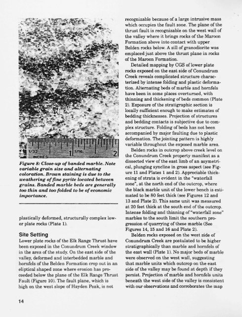
Figure 8: Close-up of handed marble. Note<br />
variable grain size and alternating<br />
coloration. Brown staining is due to the<br />
weathering of fine pyrite located between<br />
grains. Banded marble beds are generally<br />
too thin and too folded to be of economic<br />
importance.<br />
plastically deformed, structurally complex lower<br />
plate rocks (Plate 1).<br />
Site Setting<br />
Lower plate rocks of the Elk Range Thrust, have<br />
been exposed in the Conundrum Creek window<br />
in the area of the study. On the east side of the<br />
valley, deformed and interbedded marble and<br />
hornfels of the Belden Formation crop out in an<br />
eliptical shaped zone where erosion has proceeded<br />
below the plane of the Elk Range Thrust<br />
Fault (Figure 10). The fault plane, which is<br />
high on the west slope of Hayden Peak, is not<br />
14<br />
recognizable because of a large intrusive mass<br />
which occupies the fault zone. The plane of the<br />
thrust fault is recognizable on the west wall of<br />
the valley where it brings rocks of the Maroon<br />
Formation above into contact with upper<br />
Belden rocks below. A sill of granodiorite was<br />
emplaced just above the thrust plane in rocks<br />
of the Maroon Formation.<br />
Detailed mapping by CGS of lower plate<br />
rocks exposed on the east side of Conundrum<br />
Creek reveals complicated structure characterized<br />
by intense folding and plastic deformation.<br />
Alternating beds of marble and hornfels<br />
have been in some places overturned, with<br />
thinning and thickening of beds common (Plate<br />
2). Exposure of the stratigraphic section is<br />
locally sufficient enough to make estimates of<br />
bedding thicknesses. Projection of structures<br />
and bedding contacts is subjective due to complex<br />
structure. Folding of beds has not been<br />
accompanied by major faulting due to plastic<br />
deformation. The jointing pattern is highly<br />
variable throughout the exposed marble area.<br />
Belden rocks in outcrop above creek level on<br />
the Conundrum Creek property manifest as a<br />
dissected view of the east limb of an asymetrical,<br />
plunging syncline in gross aspect (see Figure<br />
11 and Plates 1 and 2). Appreciable thickening<br />
of strata is evident in the "waterfall<br />
zone", at the north end of the outcrop, where<br />
the black marble unit of the lower bench is estimated<br />
to be 80 feet thick (see Figures 12 and<br />
13 and Plate 2). This same unit was measured<br />
at 20 feet thick at the south end of the outcrop.<br />
Intense folding and thinning of "waterfall zone"<br />
marbles to the south limit the southern progression<br />
of quarrying of these marble (See<br />
Figures 14, 15 and 16 and Plate 2).<br />
Belden rocks exposed on the west side of<br />
Conundrum Creek are postulated to be higher<br />
stratigraphically than marble and hornfels of<br />
the east wall (Plate 1). No major beds of marble<br />
were observed on the west wall, suggesting<br />
that marble units which outcrop on the east<br />
side of the valley may be found at depth if they<br />
persist. Projection of marble and hornfels units<br />
beneath the west side of the valley is consistent<br />
with our observations and corroborates the map