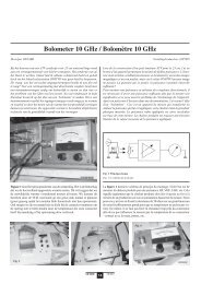
IARU Region 1 VHF Managers Handbook - UBA
IARU Region 1 VHF Managers Handbook - UBA
IARU Region 1 VHF Managers Handbook - UBA

Create successful ePaper yourself
Turn your PDF publications into a flip-book with our unique Google optimized e-Paper software.
Thanks to the effort of Folke Rasvall, SM5AGM - aided, amongst others, by ZL2AMJ (<strong>Region</strong> III)<br />
and W1XX (<strong>Region</strong> II) - agreement between the <strong>Region</strong>s could be reached and all <strong>Region</strong>s have<br />
now accepted the so-called Maidenhead Locator which henceforth will simply be known as the<br />
Locator.<br />
<strong>Region</strong> II adopted the Locator in 1982, <strong>Region</strong> III in 1983. At the <strong>IARU</strong> <strong>Region</strong> 1 Conference in<br />
Cefalu (1984) <strong>Region</strong> 1 adopted the Locator system, and the introduction date was set at January<br />
1, 1986. As from this date all official <strong>Region</strong> 1 contests are run using the new Locator system.<br />
5.12.2 Description of the Locator system<br />
The Locator system is a grid system, allowing to give the location of a station by a code consisting<br />
of six characters, viz. two capital letters, a two-digit number and, again, two capital letters. For<br />
example : JO31DG.<br />
The system is set up as follows. The globe is divided in 18 * 18 = 324 fields, each 20 degrees<br />
longitude wide and 10 degrees latitude high. Each of these fields is divided in 10 * 10 = 100<br />
squares, each 2 degrees longitude wide and 1 degree latitude high. Finally, each of the squares is<br />
divided in 24 * 24 = 576 sub-squares, each 5 minutes longitude wide and 2.5 minutes latitude<br />
wide. The coding/numbering is, as shown in Appendix 2, always from west to east and from south<br />
to north, and the origin of the system is at 180 degrees west, 90 degrees south.<br />
As far as "squares" are concerned, the system is compatible with the old QTH-Locator system,<br />
both having squares of 2 degrees longitude, 1 degree latitude. The only difference, of course, is in<br />
the coding; for instance, square CM in the QTH-Locator system will in the Locator system be<br />
square JO22. Consequently, for the collectors of "squares" continuity is assured.<br />
At the 1999 Conference in Lillehammer it was decided that a more precise definition of<br />
Alongitude@ and Alatitude@ was required. The conference decided that the latitude and<br />
longitude to be used as a reference for the determining of locators should be :<br />
5.12.3 BASIS FOR DETERMINATION OF LOCATORS<br />
The SRAL has proposed the WGS-84 geodetic system as a basis for converting latitude and<br />
longitude into a Maidenhead Locator.<br />
This proposal is important, because it thereby establishes the necessary link of the World-Wide<br />
Maidenhead Locator system with an international geodetic system.<br />
The latitude and longitude system of the Earth must be linked to a Azero point@. This point may<br />
be called a geodetic center point. There are many such points in use; by cities, countries,<br />
continents, and for the whole world. These Azero points@ are usually not coincidental. Therefore<br />
it is important to establish which geodetic system the Maidenhead Locator System should be<br />
linked to.<br />
When using a map or a GPS (Global Positioning Satellite) receiver to determine a Maidenhead<br />
Locator, it is possible to have the map or the GPS receiver calculate the locator on the basis of<br />
many different geodetic systems. In Europe the most commonly geodetic system used up to<br />
recent time has been the European Datum of 1950, called ED-50.<br />
The few last years more and more maps use their latitude and longitude linked to the newer<br />
world-wide geodetic system World Geodetic System 1984, called WGS-84.<br />
<strong>IARU</strong> <strong>Region</strong> 1 page 87/148 Version 5.40<br />
<strong>VHF</strong> managers handbook