The pilot area of Auronzo di Cadore (Belluno) - Università Ca
The pilot area of Auronzo di Cadore (Belluno) - Università Ca
The pilot area of Auronzo di Cadore (Belluno) - Università Ca

Create successful ePaper yourself
Turn your PDF publications into a flip-book with our unique Google optimized e-Paper software.
Climate change<br />
and its impacts<br />
on tourism in the Alps<br />
<strong>The</strong> <strong>pilot</strong> <strong>area</strong><br />
<strong>of</strong> <strong>Auronzo</strong> <strong>di</strong> <strong><strong>Ca</strong>dore</strong> (<strong>Belluno</strong>)<br />
Eds. Stefano Balbi,<br />
Laura Bonzanigo & <strong>Ca</strong>rlo Giupponi<br />
Centro Euro-Me<strong>di</strong>terraneo<br />
per i <strong>Ca</strong>mbiamenti Climatici<br />
<strong>Università</strong><br />
<strong>Ca</strong>’Foscari<br />
Venezia
Climate change and its impacts<br />
on tourism in the Alps<br />
-<br />
<strong>The</strong> <strong>pilot</strong> <strong>area</strong> <strong>of</strong> <strong>Auronzo</strong> <strong>di</strong> <strong><strong>Ca</strong>dore</strong> (<strong>Belluno</strong>)<br />
Summary <strong>of</strong> the activities carried out in Veneto<br />
within the ClimAlpTour project<br />
eds.<br />
Stefano Balbi<br />
Laura Bonzanigo<br />
<strong>Ca</strong>rlo Giupponi<br />
<strong>The</strong> ClimAlpTour project was funded by<br />
the European Union Territorial Cooperation<br />
as part <strong>of</strong> the Alpine Space Programme 2007 - 2013<br />
Euro-Me<strong>di</strong>terranean Centre for Climate Change<br />
Via Augusto Imperatore 16<br />
73100 Lecce<br />
www.cmcc.it<br />
ISBN 978-88-97666-01-1<br />
First printing 2011<br />
Copyright 2011 © Regione del Veneto<br />
All rights reserved<br />
graphics and e<strong>di</strong>ting<br />
blumilk.net / Grafiche 2AM<br />
printing<br />
Grafiche 2AM - Venezia
work group<br />
Balbi S. 1,2 , Bonzanigo L. 1,2 , Dissegna M. 3 , Giupponi C. 1,2 , Moretto D. 1 ,<br />
Pasutto I. 3<br />
1 <strong>Ca</strong>’ Foscari University, Venice<br />
2 Euro-Me<strong>di</strong>terranean Centre for Climate Change<br />
3 Veneto Region, Forests and Parks Unit<br />
attribution <strong>of</strong> the work tasks<br />
Stefano Balbi carried out the preliminary fieldwork, the organisation<br />
and management <strong>of</strong> the two workshops, the development <strong>of</strong> climate<br />
scenarios, the construction and application <strong>of</strong> the agent based model<br />
(as part <strong>of</strong> his PhD thesis), and the e<strong>di</strong>ting <strong>of</strong> the present report / Laura<br />
Bonzanigo organised and managed the two workshops, carried out the<br />
social network analysis, the definition and quantification <strong>of</strong> the in<strong>di</strong>cators,<br />
the ClimAlpTour e-tool configuration, and e<strong>di</strong>ted the present report<br />
/ Maurizio Dissegna coor<strong>di</strong>nated the whole ClimAlpTour project<br />
on behalf <strong>of</strong> the Veneto Region / <strong>Ca</strong>rlo Giupponi coor<strong>di</strong>nated the scientific<br />
aspects <strong>of</strong> the <strong>Auronzo</strong> case study, and particularly the environmental<br />
in<strong>di</strong>cators’ modelling and the ClimAlpTour e-tool creation and<br />
configuration / Daria Moretto contributed to both the definition and<br />
assessment <strong>of</strong> the in<strong>di</strong>cators, as part <strong>of</strong> her MSc thesis in Environmental<br />
Economics, and the organisation and running <strong>of</strong> the two workshops /<br />
Isabella Pasutto contributed to the preliminary fieldwork and the project<br />
management on behalf <strong>of</strong> the Veneto Region.<br />
acknowledgements<br />
<strong>The</strong> authors acknowledge the support <strong>of</strong> Paolo Angelini from the Italian<br />
Ministry <strong>of</strong> Environment, Land and Sea who coor<strong>di</strong>nated the Italian<br />
partners <strong>of</strong> the project and its Information and Communication features.
1<br />
1.1<br />
1.2<br />
1.3<br />
1.4<br />
1.5<br />
2<br />
2.1<br />
2.2<br />
2.3<br />
2.4<br />
3<br />
3.1<br />
3.2<br />
3.3<br />
3.4<br />
3.5<br />
3.6<br />
4<br />
4.1<br />
4.1.1<br />
4.1.2<br />
4.2<br />
4.2.1<br />
4.2.2<br />
5<br />
5.1<br />
5.1.2<br />
5.1.3<br />
Table <strong>of</strong> Contents<br />
Introduction: the ClimAlpTour project<br />
Project’s rationale<br />
Partnership<br />
Scientific objectives<br />
Project’s structure<br />
Future exploitation <strong>of</strong> results<br />
Veneto Region’s case study: <strong>Auronzo</strong> <strong>di</strong> <strong><strong>Ca</strong>dore</strong><br />
Research objective<br />
Pilot <strong>area</strong>’s description: <strong>Auronzo</strong> <strong>di</strong> <strong><strong>Ca</strong>dore</strong><br />
NetSyMoD methodology for the ClimALpTour project<br />
NetSyMoD in <strong>Auronzo</strong> <strong>di</strong> <strong><strong>Ca</strong>dore</strong><br />
Phase 1 / Actors’ Analysis<br />
Participants’ identification<br />
Interviews with potential stakeholders<br />
Outputs <strong>of</strong> the analysis<br />
Actors’ identification for the workshop<br />
Criteria Selection<br />
Possible actions <strong>of</strong> tourism developments<br />
Phase 2 / Problem Analysis and Creative System Modelling<br />
Future from stakeholders perspective: analysis<br />
<strong>of</strong> three scenarios <strong>of</strong> <strong>Auronzo</strong> winter tourism’ development<br />
in 10/15 years<br />
Scenarios<br />
<strong>The</strong> conceptual model<br />
Participatory strategy’s consolidation<br />
Attribution <strong>of</strong> weights to the main factors<br />
<strong>of</strong> a winter holiday in the Alps<br />
SWOT analysis<br />
Phase 3 / DSS design<br />
Modelling the in<strong>di</strong>cators<br />
Climate Projections<br />
Agent-Based Model (AWS1.0)<br />
8<br />
8<br />
8<br />
9<br />
10<br />
10<br />
12<br />
12<br />
13<br />
15<br />
17<br />
20<br />
20<br />
21<br />
22<br />
25<br />
26<br />
26<br />
28<br />
29<br />
29<br />
30<br />
33<br />
33<br />
34<br />
36<br />
38<br />
40<br />
42
5.1.4<br />
5.2<br />
6<br />
6.1<br />
6.1.1<br />
6.2<br />
6.3<br />
7<br />
Fig. 1<br />
Fig. 2<br />
Fig. 3<br />
Fig. 4<br />
Fig. 5<br />
Fig. 6<br />
Fig. 7<br />
Fig. 8<br />
Fig. 9<br />
Fig. 10<br />
Fig. 11<br />
Fig. 12<br />
Fig. 13<br />
Fig. 14<br />
Fig. 15<br />
Fig. 16<br />
Fig. 17<br />
Fig. 18<br />
Fig. 19<br />
Fig. 20<br />
Fig. 21<br />
Fig. 22<br />
Other in<strong>di</strong>cators<br />
Inserting data into the ClimAlpTour e-tool<br />
Phase 4 / Analysis <strong>of</strong> Options<br />
Presentation <strong>of</strong> results and weighting <strong>of</strong> criteria<br />
Results <strong>of</strong> strategies’ assessments and <strong>di</strong>scussion on outcomes<br />
<strong>Auronzo</strong> ClimAlpTour e-tool application’s key messages<br />
<strong>Auronzo</strong> <strong>di</strong> <strong><strong>Ca</strong>dore</strong>, consideration on the exercise in the <strong>area</strong><br />
Conclusions: ClimAlpTour’s key messages<br />
Table <strong>of</strong> Figures<br />
Project’s structure<br />
Map <strong>of</strong> the Municipality <strong>of</strong> <strong>Auronzo</strong> <strong>di</strong> <strong><strong>Ca</strong>dore</strong><br />
<strong>The</strong> Three Peaks <strong>of</strong> Lavaredo (2,999 m)<br />
Main methodological phases <strong>of</strong> the NetSyMoD approach<br />
NetSyMoD in <strong>Auronzo</strong> <strong>di</strong> <strong><strong>Ca</strong>dore</strong>: methods & tools<br />
Emerging social network<br />
Quality <strong>of</strong> interactions<br />
GIS map <strong>of</strong> <strong>area</strong>s <strong>of</strong> interest<br />
for potential future development strategies<br />
Cognitive map <strong>of</strong> tourism in <strong>Auronzo</strong><br />
Strategy SKINT after brainstorming<br />
Strategy ALTSKI after brainstorming<br />
Strategy BYDSNW after brainstorming<br />
Distribution <strong>of</strong> factor’s weights<br />
ScenDPSIR interface<br />
Example <strong>of</strong> Google Earth based exercise<br />
Simile interface<br />
ClimAlpTour e-tool’s catalogue <strong>of</strong> in<strong>di</strong>cators<br />
Analysis Matrix (AM)<br />
From AM to Evaluation Matrix (EM)<br />
In<strong>di</strong>cators’ clustering<br />
Weight elicitation exercise<br />
Results <strong>of</strong> strategies’ evaluation with the ClimAlpTour e-tool<br />
43<br />
44<br />
47<br />
47<br />
49<br />
50<br />
51<br />
53<br />
10<br />
13<br />
14<br />
15<br />
19<br />
23<br />
25<br />
30<br />
31<br />
31<br />
32<br />
33<br />
34<br />
37<br />
40<br />
43<br />
44<br />
45<br />
45<br />
46<br />
48<br />
49
Fig. 23<br />
Fig. 24<br />
Tab. 1<br />
Tab. 2<br />
Tab. 3<br />
Tab. 4<br />
Tab. 5<br />
Tab. 6<br />
Tab. 7<br />
Tab. 8<br />
Tab. 9<br />
Tab. 10<br />
Tab. 11<br />
Tab. 12<br />
Tab. 13<br />
Tab. 14<br />
Tab. 15<br />
Tab. 16<br />
Tab. 17<br />
Strategies ranking after weights’ elicitation (scenario B1)<br />
Sustainability triangle <strong>of</strong> the strategies evaluated (scenario B1)<br />
List <strong>of</strong> Tables<br />
<strong>Ca</strong>tegories considered for the workshop<br />
List <strong>of</strong> interviews per category<br />
A sample <strong>of</strong> questions<br />
for the social network characterisation’s phase<br />
Characteristics <strong>of</strong> <strong>Auronzo</strong>’s social network<br />
Quality <strong>of</strong> interactions’ average scores (1-6)<br />
List <strong>of</strong> actors to invite to the workshop<br />
Criteria’s ranking<br />
Identification <strong>of</strong> tourism development actions<br />
Development scenarios<br />
for <strong>Auronzo</strong>’s winter tourist <strong>of</strong>fer in brief<br />
Factors characterising winter tourism<br />
Average weight and coefficient <strong>of</strong> variation per factor<br />
SWOT analysis<br />
IPCC climate change scenarios utilised in <strong>Auronzo</strong><br />
In<strong>di</strong>cators selected to load into the ClimAlpTour e-tool<br />
Monthly change signals for temperature and precipitation<br />
Impact <strong>of</strong> climate change on <strong>Auronzo</strong><br />
Outcome <strong>of</strong> collective weighting<br />
50<br />
50<br />
21<br />
22<br />
23<br />
24<br />
25<br />
26<br />
27<br />
27<br />
29<br />
34<br />
36<br />
36<br />
38<br />
39<br />
41<br />
47<br />
48
Preface<br />
<strong>The</strong> mountain <strong>area</strong> <strong>of</strong> the Veneto Region covers a third <strong>of</strong> its entire surface.<br />
Here the importance <strong>of</strong> tourism, and especially winter tourism, has<br />
grown constantly in time, making it a primary source <strong>of</strong> alpine wealth<br />
and a driver for the regional economy. However, in the last decade, <strong>di</strong>fferent<br />
stu<strong>di</strong>es have highlighted a phase <strong>of</strong> stagnation for what concerns<br />
tourist fluxes, partly due to a lower attractiveness <strong>of</strong> the mountain tourism<br />
<strong>of</strong>fer. This might depend on <strong>di</strong>fferent social and economic factors,<br />
but also on the impacts <strong>of</strong> climate change, whose occurrence makes it<br />
<strong>di</strong>fficult to secure a sufficient snow cover throughout the entire winter<br />
season, particularly at lower elevations.<br />
In this context, the project ClimAlpTour (Climate change and its impacts<br />
on tourism in the Alps), funded by the European Union as part <strong>of</strong> the<br />
Alpine Space Programme 2007 – 2013 and led by the Veneto Region,<br />
analysed one <strong>of</strong> today’s most burning issues: the impacts <strong>of</strong> climate<br />
change on tourism in the Alpine arc with particular focus on the economic,<br />
social and environmental factors related to both summer and<br />
winter activities.<br />
<strong>The</strong> Alpine arc is characterised by both a highly heterogeneous landscape<br />
and very <strong>di</strong>ssimilar climatic con<strong>di</strong>tions, which shape the region’s<br />
overall richness in terms <strong>of</strong> ecosystems and habitats. Thus, climate<br />
change does not affect this territory homogeneously. <strong>The</strong> partnership<br />
<strong>of</strong> the ClimAlpTour project, in its attempt to cover this <strong>di</strong>versity, lists<br />
representatives <strong>of</strong> the entire Alpine region inclu<strong>di</strong>ng institutions from<br />
Italy (Veneto, Piedmont, Aosta Valley, Lombardy, Autonomous Province<br />
<strong>of</strong> Bolzano), Austria (Vienna and Tirol), France (Rhone Alpes), Germany<br />
(Bavaria), Slovenia, and Switzerland.<br />
Such comprehensiveness and the involvement <strong>of</strong> several local institutions<br />
through whose collaboration partners were able to analyse issues<br />
and peculiarities <strong>of</strong> tourism in these <strong>area</strong>s. <strong>The</strong> project revolved around<br />
the analysis <strong>of</strong> several <strong>pilot</strong> sites, which alpine were considered by experts<br />
to possess particularly significant and representative tourist and<br />
environmental con<strong>di</strong>tions. <strong>The</strong> initial surveyed data included climatic<br />
data, market data, and other economic and social parameters.
One <strong>of</strong> the main objectives <strong>of</strong> ClimAlpTour was to establish and <strong>of</strong>fer<br />
to the local administrations a decision support system for <strong>di</strong>fferentiating<br />
tourism supply while adapting to possible future changes in alpine<br />
weather con<strong>di</strong>tions due to climate change.<br />
<strong>The</strong> Veneto Region selected the <strong>pilot</strong> <strong>area</strong> <strong>of</strong> <strong>Auronzo</strong> <strong>di</strong> <strong><strong>Ca</strong>dore</strong> and<br />
Misurina because it presented great opportunities – in many instances<br />
still not fully exploited – for further developments <strong>of</strong> tourist seasons.<br />
This destination, which tra<strong>di</strong>tionally has been alpine well positioned<br />
in terms <strong>of</strong> summer tourism, is now attempting to improve the winter<br />
season supply, taking into consideration strong neighbouring competitors<br />
and environmental sustainability.<br />
<strong>The</strong> study reported herein describes the project’s experience within the<br />
Municipality <strong>of</strong> <strong>Auronzo</strong> <strong>di</strong> <strong><strong>Ca</strong>dore</strong>. Two participatory workshops alpine<br />
were conduced with the inclusion <strong>of</strong> a representative set <strong>of</strong> local stakeholders,<br />
which led to the identification and evaluation <strong>of</strong> alternative<br />
strategies for winter tourism development within a framework <strong>of</strong> adaptation<br />
measures to climate change.<br />
<strong>The</strong> President <strong>of</strong> the Veneto Region<br />
Luca Zaia
1 / Introduction: the ClimAlpTour project<br />
1.1 / Project’s rationale<br />
ClimAlpTour “Climate change and its impact on tourism in the Alpine<br />
Space”, is a 3-year research project, which started in September 2009, financed<br />
by the European Commission within the Alpine Space Programme<br />
2007-2013 - European Territorial Cooperation (Objective 3 <strong>of</strong> the Regional<br />
Policy 2007-2013) and will end in December 2011. It aims at dealing with<br />
the internationally recognized issue <strong>of</strong> the effects <strong>of</strong> climate change on alpine<br />
tourism, with specific reference to winter tourism and winter sports<br />
in some <strong>area</strong>s <strong>of</strong> the Alps (e.g. Italian Alps, French Alps, Slovene Alps, etc.)<br />
and to all-seasons tourism in other <strong>area</strong>s (e.g. German Alps). <strong>The</strong> issue<br />
<strong>of</strong> provi<strong>di</strong>ng appropriate strategies to ensure a balanced development <strong>of</strong><br />
tourism, the preparation <strong>of</strong> appropriate adaptation policies at the national,<br />
regional and local level and the assessment <strong>of</strong> the economic and social effects<br />
<strong>of</strong> climate change on tourism were issues <strong>of</strong> crucial interest in several<br />
stu<strong>di</strong>es.<br />
<strong>The</strong>re is a widespread consensus that Alpine tourism needs to be rethought<br />
and both public institutions and private stakeholders have to meet<br />
the challenge <strong>of</strong> a new idea <strong>of</strong> tourism which goes beyond the tra<strong>di</strong>tional<br />
vision <strong>of</strong> winter sports. This project addresses in particular the need to provide<br />
both a sound knowledge <strong>of</strong> the <strong>di</strong>fferent aspects <strong>of</strong> the impact <strong>of</strong> climate<br />
change on alpine tourism and concrete adaptation strategies to apply<br />
in selected <strong>area</strong>s. <strong>The</strong> choice to <strong>di</strong>rectly and in<strong>di</strong>rectly involve local actors<br />
(e.g. municipalities) was led by the intention to bring concrete outcomes<br />
on the alpine territory and to foster the inclusion <strong>of</strong> the consideration <strong>of</strong><br />
the effect <strong>of</strong> climate change on tourism in the policy agendas. On the other<br />
hand the need to increase the awareness <strong>of</strong> these issues also at the international<br />
level suggested to assure the involvement in the project <strong>of</strong> national<br />
institutions participating in international conventions (e.g. Italian Ministry<br />
<strong>of</strong> Environment, Land and Sea Protection) and <strong>of</strong> an international institutions<br />
dealing with environmental and sustainable development issues in<br />
several mountain regions worldwide, such as for instance United Nations<br />
Environment Programme.<br />
1.2 / Partnership<br />
Il partenariato e i casi <strong>di</strong> stu<strong>di</strong>o hanno interessato l’intero arco alpino. La<br />
partecipazione <strong>di</strong> tutti e sei gli stati alpini e il coinvolgimento <strong>di</strong> aree geo-<br />
8
Partners are listed in<br />
the language <strong>of</strong> their<br />
own country, followed<br />
by the country code and<br />
their acronym within the<br />
project<br />
(1)<br />
graficamente e orograficamente <strong>di</strong>verse ha permesso una visione piuttosto<br />
esauriente del turismo montano in Europa. L’obiettivo centrale è stato<br />
quello <strong>di</strong> consentire un’analisi delle peculiarità del turismo stagionale, invernale<br />
e “all-season”, proponendo soluzioni e strategie <strong>di</strong>fferenziate <strong>di</strong><br />
sviluppo turistico.<br />
<strong>The</strong> partnership and the <strong>pilot</strong> stu<strong>di</strong>es cover the whole Alpine arc. <strong>The</strong> participation<br />
<strong>of</strong> partners from six alpine countries aims at assuring a wider<br />
perspective over the issue <strong>of</strong> alpine tourism. <strong>The</strong> need to include <strong>di</strong>fferent<br />
geographical locations, <strong>di</strong>fferent orographic con<strong>di</strong>tions and <strong>di</strong>fferent tourist<br />
strategies was central in this project, thus allowing the analysis <strong>of</strong> the<br />
peculiarities <strong>of</strong> seasonal tourism, snow tourism and all year tourism.<br />
<strong>The</strong> partnership includes <strong>di</strong>fferent typologies <strong>of</strong> institutions ranging from<br />
universities and research institutes to national public administrations.<br />
Veneto Region - Directorate for Forest and Mountain Economy (RV) is the<br />
lead partner. Other partners, both EU and non-EU, are (1) : / European Academy<br />
Bolzano (IT), (EURAC); / Alpenforschungsinstitut GmbH (DE), (AFI);<br />
/ Ente Regionale per i Servizi all’Agricoltura e alle Foreste (IT), (ERSAF);<br />
/ Haute école spécialisée de Suisse occidentale Valais, Institut Economie<br />
& Tourisme (CH), (HES-SO); / Hochschule für Technik Rapperswil, Institut<br />
für Landschaft und Freiraum (CH), (HSR); / HTW Chur, Institut für<br />
Tourismus- und Freizeitforschung (CH), (HTW); / Hochschule München,<br />
Fakultät für Tourismus (DE), (HM); / Institut Universitaire Kurt Bösch (CH),<br />
(IUKB); / Ministero dell’Ambiente e della Tutela del Territorio e del Mare<br />
(IT), (MATTM); / Regione Autonoma Valle d’Aosta, Direzione Ambiente (IT),<br />
(RAVA Env); / Regione Autonoma Valle d’Aosta, Direzione Turismo (IT),<br />
(RAVA Tour); / Unione Nazionale Comuni Comunità Enti Montani (IT), (UN-<br />
CEM); / United Nations Environment Programme in Vienna (AT), (UNEP);<br />
/ Universität Innsbruck, Institut für strategisches Management, Marketing<br />
und Tourismus (AT), (UIBK); / Université de Savoie, Institut de la Montagne<br />
(FR), (InstMont); / World Wide Fund for Nature (IT), (WWF); / Znanstvenoraziskovalni<br />
center Slovenske akademije znanosti in umetnosti, Geografski<br />
inštitut Antona Melika (SI), (ZRC SAZU).<br />
1.3 / Scientific objectives<br />
<strong>The</strong> project ClimAlpTour stu<strong>di</strong>ed 24 <strong>pilot</strong> cases around the Alpine arc,<br />
through which it aimed at the following six scientific objectives: (1) to analyze<br />
<strong>di</strong>fferent possible impacts <strong>of</strong> climate change on the alpine tourist sector<br />
and their complex interrelation; (2) to provide an overview <strong>of</strong> tourist <strong>area</strong>s<br />
in the Alps where the effects <strong>of</strong> climate change can be stronger accor<strong>di</strong>ng<br />
to climate scenarios; (3) to analyze adaptation and management strategies<br />
for tourist sector which better fit in the alpine region, considering changes<br />
in customer perception and new alpine strategies for tourism industry; (4)<br />
to select a set <strong>of</strong> parameters and to identify common trends in order to<br />
feed an algorithm being able to deliver possible strategies accor<strong>di</strong>ng to the<br />
features <strong>of</strong> the examined tourist sites; (5) to build a web electronic tool<br />
9
Fig. 1<br />
Project’s structure<br />
for stakeholders being able to make a first assessment <strong>of</strong> the local impact<br />
<strong>of</strong> climate change and to provide hints for possible adaptation strategies;<br />
(6) to apply the most important strategies developed in the framework <strong>of</strong><br />
the project in <strong>pilot</strong> <strong>area</strong>s along the Alps with a <strong>di</strong>rect involvement <strong>of</strong> local<br />
authorities, stakeholders and the public aiming at raising the awareness <strong>of</strong><br />
policy makers, business sector and all relevant actors on the topic <strong>of</strong> climate<br />
change and its effect on the economy (mainly in the tourist sector).<br />
1.4 / Project’s structure<br />
<strong>The</strong> project was organised around seven work-packages, summarised below<br />
(Figure 1). (WP1) Project preparation, Application Form, Partnership<br />
Agreement (WP2) Project management, Management <strong>of</strong> work flow and<br />
budget (WP3) Information and publicity, website, expert hearing, conferences<br />
(WP4) Data survey, Collection <strong>of</strong> existing data, datasets, in<strong>di</strong>cators<br />
(WP5) Impact analyses, environmental, social, economic analysis <strong>of</strong><br />
climate change impact on tourist locations (WP6) Adaptation strategies,<br />
tailored adaptation strategies for <strong>pilot</strong> <strong>area</strong>s (WP7) Awareness raising, Information,<br />
education, communication activities for stakeholders, tourists,<br />
general public and policy makers<br />
1.5 / Future exploitation <strong>of</strong> results<br />
Results <strong>of</strong> the ClimAlpTour project aim to support activities <strong>of</strong>: (1) policy<br />
makers (local, regional, national), who can get valuable advice in new<br />
policies design for tourist alpine <strong>area</strong>s, to improve their attractiveness in<br />
all seasons and can implement concrete strategies for their territories (especially<br />
local actors); (2) business community (hotels, resorts managers,<br />
tourist operators, business clusters, advisory companies), who can get information<br />
on expected change in alpine tourism and develop strategies to<br />
counteractive negative impacts and consider new opportunities; (3) civil<br />
society (citizens, workers, students), who can know future trends and be<br />
10
eady to adapt; (4) NGOs, who can promote campaigns based on sound<br />
scientific knowledge to inform the public about risks and opportunities <strong>of</strong><br />
climate change in tourist sector; (5) academic community, who can use<br />
project outcomes to start new research in <strong>di</strong>fferent fields; (6) international<br />
institutions (UN, OECD, Alpine and <strong>Ca</strong>rpathians Convention), who wish to<br />
share the experience with other mountain <strong>area</strong>s.<br />
Project results are expected to be concretely implemented in some <strong>pilot</strong><strong>area</strong>s<br />
along the Alpine arc and general guidelines for alpine tourism will<br />
be spread also in other regions and worldwide as a positive experience to<br />
be possibly replicated elsewhere. <strong>The</strong> concrete implementation <strong>of</strong> innovative<br />
tourist strategies in some alpine locations selected in this project as<br />
<strong>pilot</strong>-<strong>area</strong>s is likely to bring positive results to the alpine economy and to<br />
increase the tourist attractiveness <strong>of</strong> the alpine space, by making a wise use<br />
<strong>of</strong> the consequences deriving from climate change to the <strong>di</strong>fferent destinations<br />
analysed within this project.<br />
<strong>The</strong> sustainability <strong>of</strong> the results is assured thanks to the will <strong>of</strong> partners to<br />
actively work for trying and implementing project main fin<strong>di</strong>ngs on their<br />
own territories. In ad<strong>di</strong>tion, the project website (www.climalptour.eu), with<br />
the most relevant products is available for the public and all the interested<br />
stakeholders beyond the project closure.<br />
11
Box 1<br />
<strong>The</strong> report in brief<br />
2 / Veneto Region’s case study:<br />
<strong>Auronzo</strong> <strong>di</strong> <strong><strong>Ca</strong>dore</strong><br />
Climate change is already significantly affecting the European Alpine Region<br />
beyond the average temperature signals that have been registered at a<br />
global level (IPCC 2007). Not even climate sceptics may deny the evidence<br />
<strong>of</strong> a 50% decrease <strong>of</strong> glaciers’ volume since 1850 (<strong>Ca</strong>stellari 2008). Establishing<br />
whether this change is human-induced or not remains beyond the<br />
scope <strong>of</strong> this study, which explores what it may imply for winter tourism<br />
in the Alps and how local development can be driven to take this new state<br />
into account.<br />
2.1 / Research objective<br />
<strong>The</strong> ultimate aim <strong>of</strong> this study was to <strong>di</strong>scuss about the future <strong>of</strong> <strong>Auronzo</strong><br />
with its people through a significant set <strong>of</strong> representatives, and more specifically<br />
about the prospects for revitalising winter tourism’s performances<br />
in a sustainable manner and the possible strategies to achieve that goal.<br />
This report <strong>di</strong>scusses the activities carried out by the research team in order<br />
to achieve this objective.<br />
Context / Municipality <strong>of</strong> <strong>Auronzo</strong> <strong>di</strong> <strong><strong>Ca</strong>dore</strong> located in the province <strong>of</strong><br />
<strong>Belluno</strong>, in the Veneto Region, in the North-east <strong>of</strong> Italy. It covers a vast<br />
<strong>area</strong> (22.000 ha) which includes Misurina with its lake and the most famous<br />
mountain <strong>of</strong> the Dolomites, namely the “Three Peaks <strong>of</strong> Lavaredo”<br />
part <strong>of</strong> the UNESCO world heritage since 2009.<br />
Problem / How to develop winter tourism in the next 40 years, in a<br />
context <strong>of</strong> climate change scenarios and market demand that are not<br />
favourable?<br />
Objectives / To compare four adaptation strategies: a. the pursue <strong>of</strong> the<br />
tra<strong>di</strong>tional downhill ski-intensive para<strong>di</strong>gm (SKINT), b. an alternative<br />
light ski-oriented post-modern development (ALTSKI), c. the process <strong>of</strong><br />
<strong>di</strong>versification and enlargement <strong>of</strong> tourist <strong>of</strong>fer beyond-snow (BYDSNW),<br />
d. no change from present situation or, in other words, “business as<br />
usual”(BAU).<br />
Of specific interest / <strong>The</strong> focus on holistic and dynamic socio-ecosystem<br />
analysis; / <strong>The</strong> involvement <strong>of</strong> local actors in a participatory process;<br />
/ <strong>The</strong> treatment <strong>of</strong> spatial heterogeneity.<br />
Methods & tools / Implementation <strong>of</strong> the NetSyMoD framework for<br />
participatory modelling and decision support, and in particular the fol-<br />
12
Fig. 2<br />
Map <strong>of</strong> the Municipality<br />
<strong>of</strong> <strong>Auronzo</strong> <strong>di</strong> <strong><strong>Ca</strong>dore</strong><br />
lowing combination <strong>of</strong> approaches and tools: 1. Social network analysis<br />
(AGNA, Pajek) 2. Conceptual mapping (IHMC Cmap) 3. Geographic Information<br />
System (Idrisi) 4. System dynamics (Simile) 5. Agent-based<br />
modelling (AWS1.0) 6. Decision-support system (ClimAlpTour e-tool)<br />
2.2 / Pilot <strong>area</strong>’s description: <strong>Auronzo</strong> <strong>di</strong> <strong><strong>Ca</strong>dore</strong><br />
<strong>The</strong> Municipality <strong>Auronzo</strong> <strong>di</strong> <strong><strong>Ca</strong>dore</strong> is located in the province <strong>of</strong> <strong>Belluno</strong>,<br />
in the Veneto Region, in the north-east <strong>of</strong> Italy (see Figure 2). It covers a<br />
vast <strong>area</strong> (22,000 ha), which includes Misurina with its lake and the “Three<br />
Peaks <strong>of</strong> Lavaredo”, the most famous mountains <strong>of</strong> the Dolomites, part <strong>of</strong><br />
the UNESCO world heritage since 2009.<br />
<strong>The</strong> town <strong>Auronzo</strong> <strong>di</strong> <strong><strong>Ca</strong>dore</strong> (866 m on the sea level) hosts nearly the entire<br />
population <strong>of</strong> the municipality <strong>of</strong> approximately 3,600 inhabitants. It is<br />
located in the Ansiei River’s valley, on the shores <strong>of</strong> the artificial Santa <strong>Ca</strong>terina<br />
Lake. <strong>The</strong> lake basin is 3 km long and is endowed with beach facilities<br />
that perio<strong>di</strong>cally host motor nautical and canoe competitions. Misurina<br />
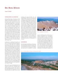
is a small settlement 25 km from <strong>Auronzo</strong>, placed at an altitude <strong>of</strong> 1,754 m<br />
beneath the Three Peaks <strong>of</strong> Lavaredo (Figure 3), which are accessible both<br />
through several mountain paths and through a toll regulated carriageway.<br />
<strong>The</strong> local economy depends on tourism, which at present is focused primarily<br />
on the summer season, whereas the winter season remains weak,<br />
with only 25% <strong>of</strong> yearly arrivals (Regione Veneto 2009). Indeed, hiking (200<br />
km <strong>of</strong> signed mountain paths and 10 alpine refuges) and relax are the main<br />
elements <strong>of</strong> attraction. <strong>The</strong> total hosting capacity is <strong>of</strong> approximately 7,300<br />
beds <strong>of</strong> which around 1,700 in the hotel sector and the remainder in the extra-hotel<br />
sector (B&Bs, lodgings, and so forth). 75% <strong>of</strong> the hotels’ beds are<br />
located within 1 or 2 starred facilities. In 2008, 63,700 arrivals and 305,400<br />
tourist nights were registered, showing a slight decrease from the previous<br />
year. <strong>The</strong> last 10 years have witnessed the increase <strong>of</strong> arrivals but the contraction<br />
<strong>of</strong> average stays.<br />
Notwithstan<strong>di</strong>ng the presence <strong>of</strong> two small downhill ski-<strong>area</strong>s and two<br />
13
Fig. 3<br />
<strong>The</strong> Three Peaks <strong>of</strong> Lavaredo<br />
(2.999 m)<br />
cross-country ski-centres, some hotels do not even open for the winter<br />
season. <strong>The</strong> four ski-lifts <strong>of</strong> Mount Agudo, which reach a maximum elevation<br />
<strong>of</strong> 1,600 m, connect seven ski-pistes for a total 15 km. In the locality <strong>of</strong><br />
Palus San Marco, halfway between <strong>Auronzo</strong> and Misurina, there lays the<br />
Soma<strong>di</strong>da Forest, one <strong>of</strong> the province’s largest, which becomes a crosscountry<br />
ski-centre (with nine loops <strong>of</strong> a total 52.5 km) during the winter<br />
season. <strong>The</strong> Marmarole sled-dog centre and an ice-kart circuit are also located<br />
in Palus. In ad<strong>di</strong>tion, Misurina, which has an hosting capacity <strong>of</strong> approximately<br />
500 beds is endowed with two ski-lifts <strong>of</strong> Col de Varda (from<br />
1,756 m to 2,220 m) that connect five ski-pistes, and 17 km <strong>of</strong> cross-country<br />
ski loops. Recently, the Community Council begun to consider options for<br />
stimulating winter tourism. At present, there exist several projects <strong>of</strong> ski<strong>area</strong>s<br />
development. <strong>The</strong> most ambitious is located in Marzon valley, a few<br />
km from the main village, which would connect the valley to the ski-<strong>area</strong><br />
<strong>of</strong> Misurina (with an average altitude over 2,000 m). After a preliminary<br />
consultation with the local public administration, there emerged their preference<br />
for a study on how to develop winter tourism in the next 40 years,<br />
in a context <strong>of</strong> climate change (warming effect on snow availability) and<br />
market demand (ageing population) that is not favourable.<br />
2.3 / NetSyMoD methodology for the ClimALpTour project<br />
<strong>The</strong> chosen methodology, named NetSyMoD (Network Analysis - Creative<br />
System Modelling - Decision Support), is a flexible but comprehensive methodological<br />
framework that was developed during several years <strong>of</strong> research<br />
conducted by Pr<strong>of</strong>. <strong>Ca</strong>rlo Giupponi (www.netsymod.eu). In order to facilitate<br />
the decision-making process, this methodological approach assembles various<br />
tools that aim primarily at the identification <strong>of</strong> key actors within a given<br />
decision-making context, and then at their involvement in those develop-<br />
14
Fig. 4<br />
Principali componenti<br />
metodologiche<br />
dell’approccio NetSyMoD<br />
ment phases where models <strong>of</strong> analysis are constructed (Figure 4).<br />
<strong>The</strong> NetSyMoD logo (middle <strong>of</strong> Figure 5) is a symbolic picture <strong>of</strong> the limited<br />
resources available (e.g. water in the carafe), and <strong>of</strong> the various users<br />
(glasses) with <strong>di</strong>fferent needs (varying quantity and colour). <strong>The</strong> main<br />
phases that constitute the NetSyMoD fabric are:<br />
1. Actors’ analysis / to identify all the potential carriers <strong>of</strong> interest/<br />
experts on the matter under <strong>di</strong>scussion. <strong>The</strong> proposed method suggests<br />
the organisation <strong>of</strong> brainstorming sessions with a limited sample<br />
<strong>of</strong> stakeholders, all <strong>of</strong> whom should be grounded on the issue, who sin-<br />
15<br />
gle out those most apt to attend the participatory phases. A “snow-ball”<br />
technique is <strong>of</strong>ten applied as it allows selecting a whole group <strong>of</strong> actors<br />
interested in the decision-making project, whether <strong>di</strong>rectly or in<strong>di</strong>rectly.<br />
This phase includes a Social Network Analysis (SNA), which aims to represent<br />
the relationship between the identified stakeholders <strong>of</strong> a given<br />
social network. Such analysis permits to highlight roles, responsibilities,<br />
and relationships <strong>of</strong> every actor within that network, which in turn<br />
may lead to a second selection <strong>of</strong> stakeholders to invite to the successive<br />
phases. This process both limits the risk for the participatory process to<br />
be hindered by some powerful groups and ensures a high rate <strong>of</strong> representativeness<br />
whilst at the same time maintaining the number in a<br />
manageable size.<br />
2. Problem Analysis / In this phase the problem (or conflict) at<br />
hand is scrutinised from various perspectives and viewpoints. <strong>The</strong> environment<br />
in which the problem is embedded is explored and the relevant<br />
factors identified. <strong>The</strong> problems faced by environmental resource planners<br />
and managers are complex and their drivers interwoven. It is necessary<br />
to identify the most relevant aspects, by focusing on which the<br />
major changes can be attained. <strong>The</strong> exploration <strong>of</strong> the problem includes<br />
analyses <strong>of</strong> legal and institutional frameworks, as well as the economy<br />
on various spatial levels and the state <strong>of</strong> environment. Future development<br />
<strong>of</strong> main drivers and pressures are simulated using models which<br />
assess alternative scenarios. Different stakeholders (identified in previ-
conceived during the<br />
EU FP5 project MULINO<br />
“MULtisectoral, INtegrated<br />
and Operational Decision<br />
Support System for<br />
sustainable use <strong>of</strong> water<br />
resource at the catchment<br />
scale”<br />
(2)<br />
16<br />
ous step, Actor analysis) hold <strong>di</strong>fferent perceptions and beliefs about<br />
what are the causes <strong>of</strong> the problem or how it should be tackled. Different<br />
techniques have been developed to surface tacit knowledge and deeply<br />
held beliefs, inclu<strong>di</strong>ng conflict assessment, problem-structuring methods,<br />
<strong>di</strong>scourse analysis. <strong>The</strong> in<strong>di</strong>vidual perspectives are further elaborated<br />
in the next step (Creative system modelling) to facilitate collective<br />
learning and shared (agreed) boundaries <strong>of</strong> the problem. <strong>The</strong> main<br />
outputs <strong>of</strong> this phase are: (i) a list <strong>of</strong> most relevant drivers governing<br />
the perception <strong>of</strong> the problem at hand; (ii) a preliminary list <strong>of</strong> possible<br />
solutions can<strong>di</strong>date to be assessed; (iii) A set <strong>of</strong> scenarios regar<strong>di</strong>ng the<br />
future development <strong>of</strong> the main drivers and cause-effect relations; (iv)<br />
an extensive list <strong>of</strong> in<strong>di</strong>cators against which the performance <strong>of</strong> the possible<br />
solutions (alternative options) should be measured.<br />
3. Creative system modelling / (CSM), to represent in a correct<br />
manner the knowledge, opinions, and the preferences <strong>of</strong> the stakeholders<br />
involved. <strong>The</strong> key actors gather in a meeting during which the<br />
problem is conceptualised through the construction <strong>of</strong> cognitive maps<br />
- in<strong>di</strong>vidual and/or collective. Such exercises, elicited accor<strong>di</strong>ng to the<br />
context, allow the representation <strong>of</strong> the various understan<strong>di</strong>ng <strong>of</strong> the<br />
system under analysis. During this phase one can also proceed to the<br />
shared construction <strong>of</strong> the cause-effect chains, through either the conceptual<br />
model DPSIR (Determinants, Pressures, State, Impacts, and Response)<br />
or the elaboration <strong>of</strong> future scenarios that stimulate the identification<br />
<strong>of</strong> potential solutions/ innovative approaches to the problem<br />
under scrutiny.<br />
4. DSS Design / In this phase, all the information gathered during<br />
the previous phases <strong>of</strong> the NetSyMoD methodology are assembled<br />
through the Decision-Support-System ClimAlpTour e-tool, an updated<br />
version <strong>of</strong> mDSS, a s<strong>of</strong>tware (2) , capable <strong>of</strong> managing the data required<br />
for provi<strong>di</strong>ng informed and robust decision in the following phase. <strong>The</strong><br />
latest version <strong>of</strong> the ClimAlpTour e-tool adds a multicriteria spatial analysis<br />
to the previous mDSS versions. This is necessary to manage and<br />
communicating the information flow between various process phases,<br />
inclu<strong>di</strong>ng exchange, transformation, integration, validation and documentation<br />
<strong>of</strong> gathered knowledge. Many <strong>of</strong> the previous analyses employ<br />
computer-based tools such as databases (and data management<br />
systems), visualisation components, and simulation models. Different<br />
tools are frequently assembled into a comprehensive Decision Support<br />
Systems, normally employing various interconnected and adapted<br />
components, controlled by an user interface.<br />
This phase address all activities related to the development <strong>of</strong> interoperable<br />
and useable s<strong>of</strong>tware components; and collection <strong>of</strong> well-documented<br />
and easily exchangeable data sets (inclu<strong>di</strong>ng spatial data and<br />
time series). In the end, one <strong>di</strong>sposes <strong>of</strong> (i) seamless data flow between<br />
various tools and s<strong>of</strong>tware component; (ii) user interface which guides
17<br />
user though various stages <strong>of</strong> the NetSyMoD process; (iii) quality assurance<br />
regar<strong>di</strong>ng the integration <strong>of</strong> <strong>di</strong>fferent components, and (iv) documentation<br />
and report facilities which explain the process and facilitate<br />
the interpretation <strong>of</strong> results.<br />
5. Analysis <strong>of</strong> options / <strong>The</strong> analysis <strong>of</strong> options consist <strong>of</strong> evaluating<br />
and choosing one (or more) solution to the problem (e.g. a policy measure,<br />
plan or project) from a set <strong>of</strong> alternatives, or producing their complete<br />
ranking. Numerous methods and techniques have been developed<br />
in decision theory to make explicit (transparent) value judgements and<br />
assess the extent to which <strong>di</strong>fferent options may contribute to achieve<br />
the pursued goals and objectives. Decision models result from the systematic<br />
exploration <strong>of</strong> a ‘problem’, inclu<strong>di</strong>ng its existence, boundaries<br />
and structure. <strong>The</strong>y comprise alternative courses <strong>of</strong> actions; decision<br />
goals - translated into more tangible evaluation criteria - against which<br />
the policies are weighed; and preferences, which describe how well the<br />
various options satisfy the objectives. Decision methods help to avoid<br />
inconsistencies underlying judgement and choice, and make decisions<br />
more compatible with normative axioms <strong>of</strong> rationality. Furthermore, if<br />
combined with deliberative techniques, decision methods render policy<br />
processes transparent and informed the perspectives or viewpoints <strong>of</strong><br />
all actors. This is translated into a higher acceptance <strong>of</strong> the policies. <strong>The</strong><br />
ClimAlpTour e-tool allows the ordering <strong>of</strong> the various options under examination<br />
and thus it facilitates the decision-makers’ final choice. Given<br />
that the in<strong>di</strong>cators selected then truly represents the various interests<br />
and opinions <strong>of</strong> the actors, a multicriteria analysis is carried out - both<br />
in<strong>di</strong>vidually and collectively.<br />
2.4 / NetSyMoD in <strong>Auronzo</strong> <strong>di</strong> <strong><strong>Ca</strong>dore</strong><br />
<strong>The</strong> work carried out in <strong>Auronzo</strong> <strong>di</strong> <strong><strong>Ca</strong>dore</strong> consists primarily <strong>of</strong> two workshops,<br />
for whose organisation other parallel activities took place. Overall,<br />
it aimed at raising awareness <strong>of</strong> climate change and its future impacts on<br />
the tourist sector (WP7 <strong>of</strong> ClimAlpTour project). <strong>The</strong> process was structured<br />
around the NetSyMoD phases, as visualised in Figure 5.<br />
Actors’ Analysis (1) aimed at the selection <strong>of</strong> workshop’s participants. Field<br />
data was processed with two s<strong>of</strong>twares for SNA, namely AGNA (analysis)<br />
and Pajek (visualisation). Problem Analysis (2) and Creative System Modelling<br />
(3) led to consolidated strategies, visualised in IHMC Cmap, ranked by<br />
stakeholders and assessed in terms <strong>of</strong> a Strengths/Weaknesses/Opportunities/Threats<br />
framework (SWOT) frame. In the DSS design (4-5) phase, the<br />
performance <strong>of</strong> each selected strategy under future scenarios was calculated,<br />
utilising several modelling tools for quantifying various families <strong>of</strong><br />
(social, economic, and environmental) in<strong>di</strong>cators. For instance, an agent<br />
based model - <strong>Auronzo</strong>WinSim 1.0 (AWS1.0) - simulated the behaviour <strong>of</strong><br />
tourism demand and derived socio-economic in<strong>di</strong>cators, whilst system<br />
dynamics (Simile) and statistical models (SkiSim 2.0) were applied for cal-
culating environmental in<strong>di</strong>cators, such as erosion and natural snow availability.<br />
All these in<strong>di</strong>cators contributed to inform the final e-tool settings,<br />
which enabled us to prepare an Evaluation Matrix for the analysis <strong>of</strong> the<br />
options/strategies to submit to the participants during the second workshop.<br />
Finally, for the analysis <strong>of</strong> options (6), participants proceeded to the<br />
assessment <strong>of</strong> the appropriateness <strong>of</strong> the strategies. After attributing relative<br />
importance to the criteria <strong>of</strong> judgement, in<strong>di</strong>vidual assessments were<br />
me<strong>di</strong>ated in the ClimAlpTour e-tool environment in order to produce one<br />
preferred strategy, emerging as a group-decision.<br />
<strong>The</strong> first workshop, held in <strong>Auronzo</strong> on 7th June 2010, aimed at (i) engaging<br />
local actors interested in the promotion <strong>of</strong> winter tourism in <strong>Auronzo</strong>; (ii)<br />
buil<strong>di</strong>ng and evaluate potential future scenarios <strong>of</strong> the tourist <strong>of</strong>fer in 10-<br />
15 years from now and consequential strategies that may be adopted; (iii)<br />
contributing to local debate on tourism.<br />
<strong>The</strong> second workshop, held in <strong>Auronzo</strong> on 24th September 2010, aimed<br />
to fulfil five main objectives: (i) to present the instrument utilised for the<br />
evaluation <strong>of</strong> the strategies refined during the first workshop; (ii) to present<br />
the analysis work that followed the first workshop, both in terms <strong>of</strong> in<strong>di</strong>cators<br />
and models; (iii) to elicit weights for the evaluation criteria; (iv) to rank<br />
the strategies with the ClimAlpTour e-tool’s multicriteria analysis option;<br />
(v) To facilitate <strong>di</strong>scussion on results.<br />
<strong>The</strong> following chapters describe in depth the exercise carried out in <strong>Auronzo</strong><br />
for the definition and evaluation <strong>of</strong> alternative mid-term strategies<br />
for the development <strong>of</strong> <strong>Auronzo</strong> as a successful winter destination.<br />
18
Fig. 5<br />
NetSyMoD in <strong>Auronzo</strong><br />
<strong>di</strong> <strong><strong>Ca</strong>dore</strong>: methods & tools<br />
methods & tools<br />
Implementation <strong>of</strong> the NetSyMoD framework for<br />
participatory modelling and decision support, and<br />
in particular the following combination <strong>of</strong> approaches<br />
and tools<br />
1 Social network analysis (Pajek, AGNA)<br />
2 Conceptual mapping (Cmap, SIMOS, SWOT)<br />
3 Geographic Information System (Idrisi)<br />
4 System dynamics (Simile)<br />
5 Agent-based modelling (AWS1.0)<br />
6 Decision-support system (ClimAlpTour e-tool)<br />
19
Box 2<br />
SNA in brief<br />
3 / Phase 1 / Actors’ Analysis<br />
Social network analysis (SNA) focuses on relationships among social<br />
entities, and on the patterns and implications <strong>of</strong> social relationships.<br />
It entails a representation <strong>of</strong> social environment in terms <strong>of</strong> patterns<br />
and regularities in relationships amongst interacting units (Wasserman<br />
& Faust, 1999; Scott, 2000).<br />
Main outputs / <strong>The</strong>re are three main outputs from the SNA phase,<br />
which will be an input into the preparatory phase for the Creative System<br />
Modelling (CSM) exercise. / A list <strong>of</strong> key stakeholders/experts to be<br />
involved in the next phases <strong>of</strong> NetSyMoD. This will limit the number <strong>of</strong><br />
participants to a manageable size, and ensure that no important actors<br />
are left out <strong>of</strong> the exercise. / <strong>The</strong> analysis <strong>of</strong> power will highlight potentially<br />
problematic actors and relations, whom the facilitator will need<br />
to actively manage during the creative system modelling workshop. / A<br />
conflict analysis on the basis <strong>of</strong> position and roles <strong>of</strong> actors within the<br />
network, with the purpose <strong>of</strong> identifying key alleys and/or opponents,<br />
and actors who are opinion setters.<br />
SNA unfolds in five phases: participants’ preliminary identification, interviews<br />
with a sample <strong>of</strong> stakeholders, successive characterisation <strong>of</strong> their<br />
social network, identification <strong>of</strong> initial scenarios and criteria for their evaluation,<br />
and actors’ final selection for the workshops.<br />
3.1 / Participants’ identification<br />
After a couple <strong>of</strong> preliminary visits to the field, the destination was charaterised<br />
in terms <strong>of</strong> categories and main activities, that should have a stake<br />
in the workshop in an attempt to represent all interests.<br />
Given the very nature <strong>of</strong> the participatory process, designed to promote<br />
everyone’s contribution, the number <strong>of</strong> attendances was narrowed to 20<br />
on the basis <strong>of</strong> the organisers’ previous experiences in similar environment.<br />
In ad<strong>di</strong>tion, the organisers sought to include also a small sample <strong>of</strong><br />
participants that live outside the Municipality – but who could nevertheless<br />
contribute to the debate because <strong>of</strong> their expertise in the matter under <strong>di</strong>scussion.<br />
Table 1 below illustrates the five main categories and the 20 subcategories<br />
identified as potentially relevant participants <strong>of</strong> the workshop.<br />
Given the competitiveness and <strong>di</strong>fferent developments <strong>of</strong> the two main<br />
20
Tab. 1<br />
<strong>Ca</strong>tegories considered<br />
for the workshop<br />
tourists’ destinations (<strong>Auronzo</strong> <strong>di</strong> <strong><strong>Ca</strong>dore</strong> and Misurina) within the Municipality,<br />
at times it was necessary to consult for each category, one representatives<br />
from each <strong>area</strong>. For instance, both Presidents <strong>of</strong> the two skiing<br />
schools, the two companies managing the two skiing resorts, and so forth<br />
were contacted.<br />
In total, 41 names <strong>of</strong> in<strong>di</strong>viduals were chosen as representative <strong>of</strong> the categories<br />
mentioned below in Table 1 that should be (possibly) interviewed<br />
and perhaps invited to the workshop.<br />
a<br />
b<br />
3.2 / Interviews with potential stakeholders<br />
After provi<strong>di</strong>ng a standard SNA questionnaire to a few “sample-tests”, this<br />
was refined with their inputs and proceeded to the main structured-interviewing<br />
phase that aimed primarily at assessing the reciprocal relationship<br />
among actors. This part allowed the identification <strong>of</strong> the key actors and the<br />
characterisation <strong>of</strong> their role and position with respect to the decision to be<br />
taken. It also both highlighted past, present, and/or potential conflicts that<br />
might hinder the development <strong>of</strong> the workshop and provided information<br />
about the various actors’ opinions that were necessary for the organisation<br />
<strong>of</strong> the workshop. <strong>The</strong> questionnaires comprised <strong>of</strong> four main parts:<br />
1. General information about the interviewee and the institution that he/<br />
21<br />
CATEGORY SUB-CATEGORY<br />
Government /<br />
para-government<br />
Tourist housing /<br />
fee<strong>di</strong>ng<br />
c Tourists' entertainment<br />
d<br />
e<br />
Tourists' / events'<br />
management<br />
Facilities both<br />
for locals and tourists<br />
f Tourists<br />
1 Public administration<br />
2 Technical <strong>of</strong>fice<br />
3 “Regole” (family communal bo<strong>di</strong>es)<br />
4 Hotels/Restaurants<br />
5 Chalets<br />
6 Agrotourisms<br />
7 Estate-agents<br />
8 Construction companies<br />
9 Skiing Schools<br />
10 Skiing resort<br />
11<br />
Skiing-unrelated activities<br />
(indoor sports, spa, ice-karts, pubs)<br />
12 Alpine guides<br />
13 Italian Alpine Club (CAI)<br />
14 Tourist <strong>of</strong>fice<br />
15 Tourism board<br />
16 Business<br />
17 Press<br />
18<br />
Emergency organisations<br />
(alpine rescue, civil protection body)<br />
19 With holiday homes<br />
20 Without holiday homes
(3)<br />
As it appears, tourists<br />
were excluded from this<br />
round <strong>of</strong> interviews,<br />
which had the specific<br />
focus to contextualise<br />
tourism supply in <strong>Auronzo</strong><br />
<strong>di</strong> <strong><strong>Ca</strong>dore</strong>.<br />
Tab. 2<br />
List <strong>of</strong> interviews<br />
per category<br />
she represented. 2. Social Network identification, where the interviewee<br />
listed the frequency, quality, and nature <strong>of</strong> his institution’s interactions<br />
with the others on the list. 3. Position’s analysis, where he/she could express<br />
his/her opinion on the potential strategies to adopt and the criteria to<br />
value the final choice against. 4. Conflicts’ analysis over the use <strong>of</strong> natural<br />
resources for tourism’s purposes.<br />
With the twenty stakeholders interviewed, the majority <strong>of</strong> the categories<br />
was covered (Table 2) (3) . Respondents were also asked to mention other<br />
potential actors for the workshop (the so-called “snowball technique”, that<br />
reduces the possibility <strong>of</strong> leaving key actors unaccounted for). As a result,<br />
the initial list was enlarged to comprise about 50 names belonging to the<br />
first five categories elicited in. It should be specified here that the majority<br />
<strong>of</strong> the actors interviewed represented more than one category. Although<br />
theoretically they answered the questionnaire for one institution, overlapping<br />
might have <strong>of</strong>ten occurred. For instance, the Municipality owns 80%<br />
<strong>of</strong> the shares <strong>of</strong> the ski-resort <strong>Auronzo</strong> d’Inverno and is de facto the owner<br />
<strong>of</strong> the Tourism board <strong>Auronzo</strong>-Misurina. When attempting to characterise<br />
the relationship between the various institutions that operate in the <strong>area</strong>,<br />
not only the presence <strong>of</strong> exchange, but also its typology and frequency in<br />
terms <strong>of</strong> both data and information exchange and participatory planning<br />
were assessed (Table 3).<br />
3.3 / Outputs <strong>of</strong> the analysis<br />
Once collected, the field data was inserted the data in the Pajek and the<br />
AGNA (Applied Graph and Network Analysis) s<strong>of</strong>twares that supported<br />
22<br />
MAIN<br />
CATEGORY<br />
a/e<br />
INSTITUTIONS<br />
Public admininistrator<br />
(opposition)<br />
and businessman<br />
MAIN<br />
CATEGORY<br />
a Technical <strong>of</strong>fice c<br />
c<br />
INSTITUTIONS<br />
<strong>Auronzo</strong> d'Inverno<br />
(skiing resort)<br />
Skiing school<br />
<strong>Auronzo</strong>-Misurina<br />
a Villapiccola land authority c Italian Alpine Club <strong>Auronzo</strong><br />
b Panoramic hotel c Fitness and spa centre<br />
b<br />
Rinbianco<br />
alpine agritourism<br />
c<br />
Tourism Consortium<br />
<strong>Auronzo</strong>-Misurina<br />
b Estate-agent c Skiing school Tre Cime Misurina<br />
b Padova alpine refuge c MisurinaNeve (skiing resort)<br />
b<br />
Misurina alpine malga<br />
(agritourism)<br />
c Alpine guide d<br />
d Tourism consultant VAS<br />
Tourist <strong>of</strong>fice Dolomiti<br />
(provincia BL)<br />
c Alpine guide e Monti sawmill
Tab. 3<br />
A sample <strong>of</strong> questions<br />
for the social network<br />
characterisation’s phase<br />
Fig. 6<br />
Emerging social network<br />
-<br />
For reference number, see<br />
Table 4. <strong>The</strong> <strong>di</strong>fferent shapes<br />
represent the categories,<br />
which in<strong>di</strong>viduals belong to.<br />
Is there any<br />
interaction<br />
between<br />
your institution<br />
and…<br />
respectively the analysis and visualisation <strong>of</strong> the results. In Figure 6 and<br />
Figure 7 below, the various institutions are represented as nodes, whereas<br />
the edges that unite the nodes in<strong>di</strong>cate the existence <strong>of</strong> institutional<br />
interaction. <strong>The</strong> size <strong>of</strong> the nodes represents<br />
the overall scores that each received from the<br />
other interviewees. <strong>The</strong> thinner is the edge between<br />
two nodes, the worst the frequency <strong>of</strong><br />
the actors’ interaction. <strong>The</strong> frequency <strong>of</strong> the<br />
SNA is graphically represented below, if simplified<br />
(Figure 6 below). For sake <strong>of</strong> simplification,<br />
reciprocity was assumed.<br />
As it appears in Figure 6, the social network<br />
that emerges from this preliminary analysis<br />
is very compacted. Although to <strong>di</strong>fferent extents,<br />
the interviewees are inter-related. No<br />
sub-groups operate independently from the<br />
others. <strong>The</strong> network density <strong>of</strong> 0.52 in<strong>di</strong>cates<br />
that 52% <strong>of</strong> the relationships that could occur<br />
indeed materialise. Nevertheless, there emerges<br />
some <strong>di</strong>fference in the number <strong>of</strong> actors to<br />
which each institution is connected: from a<br />
minimum <strong>of</strong> 2 <strong>of</strong> “Civil Protection” (n.17) to a maximum <strong>of</strong> 20 <strong>of</strong> the “tourism<br />
board <strong>Auronzo</strong>-Misurina” (n.11) and the Municipality’s technical <strong>of</strong>fice<br />
(n.2). Strong interactions occur also with and between tourist entertainment<br />
groups (alpine guides, skiing instructors, and so forth).<br />
Table 4 summarises the number <strong>of</strong> relations <strong>of</strong> each institution considered.<br />
It appears that both “estate-less” and “second-home” tourists have <strong>di</strong>rect<br />
contact with 73% <strong>of</strong> the other actors.<br />
Not only social interactions vary in frequency, but their quality fluctuates<br />
significantly (see Figure 7). Thus, respondents were asked to in<strong>di</strong>cate the<br />
quality <strong>of</strong> interaction with the other nodes. “1” stood for “appalling”, “6” for<br />
“optimal”. Table 5 reports the average mark that each institution received<br />
from the others in terms <strong>of</strong> quality <strong>of</strong> relationship. Although the average<br />
remains quite positive, with an average score <strong>of</strong> 4.5 out <strong>of</strong> 6, Villagrande<br />
land authority seems to score the worst result, with an average <strong>of</strong> 2.1 (scarce<br />
quality). Conversely, the Consorzio remains at the top, together with MisurinaNeve,<br />
the company that owns the lifts in Misurina. Alpine rescue,<br />
which in terms <strong>of</strong> frequency was one <strong>of</strong> the lowest, is however recognised<br />
23<br />
How many<br />
times per<br />
year?<br />
How do you<br />
judge the<br />
quality <strong>of</strong><br />
this interaction?<br />
How <strong>of</strong>ten do<br />
you ask info/<br />
data exchange<br />
to…?<br />
How <strong>of</strong>ten<br />
do you share<br />
info/data<br />
with…?<br />
How do you<br />
judge the<br />
quality <strong>of</strong><br />
this info<br />
exchange?
Tab. 4<br />
Characteristics <strong>of</strong> <strong>Auronzo</strong>’s<br />
social network<br />
(*) relative to number <strong>of</strong> all<br />
other nodes (self excluded)<br />
as <strong>of</strong>fering a good service by those who interact with the body.<br />
<strong>The</strong> various institutions interviewed generally sought for a wider space for<br />
participatory long-term strategic planning.<br />
Although at times data and information are exchanged, only few collaborate<br />
for planning and decisional activities, mainly for the organisation<br />
<strong>of</strong> events (CAI, tourist <strong>of</strong>fice, sometimes the Municipality - <strong>of</strong>ten through<br />
Tourism board, few hotels).<br />
3.4 / Actors’ identification for the workshop<br />
In light <strong>of</strong> the results <strong>di</strong>scussed above, some actors were assigned priority.<br />
Sometimes it occurred that the same person would fit into various<br />
categories, hence the highest number <strong>of</strong> actors in the right column than<br />
those actually invited to the workshops. In ad<strong>di</strong>tion, four external actors<br />
were invited, respectively from a mountain chalet in the region, which<br />
opens in winter, a tourism consultant, a tourism entrepreneur who has<br />
worked with surroun<strong>di</strong>ng countries and <strong>area</strong>s, and the press.<br />
24<br />
NODO NUMERO DI RIF.<br />
PUNTO<br />
(DEGREE)<br />
* DEGREE<br />
RELATIVO<br />
Public administration 1 10 0.45<br />
Technical <strong>of</strong>fice 2 19 0.86<br />
Regole Villapiccola 3 9 0.40<br />
Hotels / Rest <strong>Auronzo</strong> 4 15 0.68<br />
Chalets 5 13 0.59<br />
Agritourism 6 15 0.68<br />
Estate agents 7 10 0.45<br />
Italian Alpine Club (CAI) 8 13 0.59<br />
Skiing school <strong>Auronzo</strong> - Misurina 9 14 0.63<br />
Alpine guides 10 15 0.68<br />
Tourism board 11 18 0.81<br />
Businesses 12 13 0.59<br />
Construction companies 13 6 0.27<br />
MisurinaNeve 14 9 0.40<br />
Tourist <strong>of</strong>fice Dolomiti 15 15 0.68<br />
Civil protection body 16 2 0.09<br />
Alpine rescue 17 5 0.22<br />
<strong>Auronzo</strong> d'Inverno 18 12 0.55<br />
“Estate-less” tourist 19 16 0.73<br />
Second-home tourist 20 16 0.73<br />
Hotels Misurina 21 16 0.73<br />
Skiing school Tre Cime - Misurina 22 12 0.55<br />
Regole Villagrande 23 11 0.50
Fig. 7<br />
Quality <strong>of</strong> interactions<br />
-<br />
For reference number, see<br />
Table 4. <strong>The</strong> <strong>di</strong>fferent shapes<br />
represent the categories,<br />
which in<strong>di</strong>viduals belong to.<br />
Tab. 5<br />
Quality <strong>of</strong> interactions’<br />
average scores (1-6)<br />
25<br />
INSTITUTION<br />
Due to their non strategic role, at this stage <strong>of</strong><br />
the analysis, alpine rescue, civil protection,<br />
and Regole Villapiccola were excluded.<br />
3.5 / Criteria Selection<br />
Interviewees ranked a list <strong>of</strong> evaluation criteria<br />
from 0 (“I do not know”) to 1 (“useless”),<br />
to 5 (“very important”), with the ad<strong>di</strong>tional<br />
possibility to express no opinion. <strong>The</strong><br />
selection <strong>of</strong> the criteria was determined on<br />
the basis <strong>of</strong> the initial fieldwork and checked<br />
with the sample actors before the interviewing<br />
phase.<br />
<strong>The</strong> criteria themselves have been classified<br />
accor<strong>di</strong>ng to the three sustainability pillarssocial,<br />
economic, and environmental.<br />
AVERAGE<br />
SCORE<br />
1 Public administration 4.1 13<br />
INSTITUTION<br />
Construction<br />
companies<br />
AVERAGE<br />
SCORE<br />
2 Technical <strong>of</strong>fice 4.7 14 MisurinaNeve 5.7<br />
3 Regole Villapiccola 3.7 15 Tourist <strong>of</strong>fice Dolomiti 5.6<br />
4<br />
Hotels / Restaurants<br />
<strong>Auronzo</strong><br />
This section <strong>of</strong> the questionnaire aimed at the identification <strong>of</strong> some<br />
in<strong>di</strong>cators to utilise during the following workshop in the evaluation <strong>of</strong><br />
the various strategies identified.<br />
Given the contained number <strong>of</strong> respondents and criteria, the in<strong>di</strong>vidual<br />
marks were aggregated in a simple manner: the cumulative mark <strong>of</strong><br />
3.5<br />
5.2 16 Civil protection body 4.3<br />
5 Chalets 4.3 17 Alpine rescue 5.2<br />
6 Agritourism 4.6 18 <strong>Auronzo</strong> d'Inverno 5.4<br />
7 Estate-agents 3.4 19 “Estate-less” tourist 4.7<br />
8 CAI 5.2 20 Second-home tourist 5.3<br />
9<br />
Skiing school<br />
<strong>Auronzo</strong>-Misurina<br />
10 Alpine guides 4.7 22<br />
5.2 21 Hotels Misurina 4.1<br />
Skiing school Tre Cime<br />
Misurina<br />
11 Tourism board 5.8 23 Regole Villagrande 2.1<br />
12 Businesses 4.8<br />
4.3
Tab. 6<br />
List <strong>of</strong> actors to invite<br />
to the workshop<br />
each criterion was calculated by summing the in<strong>di</strong>vidual answers. <strong>The</strong>n,<br />
x the first criteria per category <strong>of</strong> sustainability were aggregated. In order<br />
to maintain anonymity, the order <strong>of</strong> the scores in the single answers<br />
is random (Table 7).<br />
3.6 / Possible actions <strong>of</strong> tourism developments<br />
Similarly, respondents were also asked to rank certain actions accor<strong>di</strong>ng<br />
to how useful they considered them for the development <strong>of</strong> more<br />
competitive tourism in the <strong>Auronzo</strong>.<br />
a<br />
b<br />
c<br />
d<br />
e<br />
Those actions in Table 8 which ranked 5, 8, 9, 10, and 11 were outlined by<br />
some interviewees and as such, not posited to all, which may explain<br />
the higher presence <strong>of</strong> “0” and their overall low ranking. A better coor<strong>di</strong>nation<br />
between the various stakeholders emerges as an utter priority<br />
for the development <strong>of</strong> a sound strategy for the future.<br />
<strong>The</strong> above results on criteria selection and development actions’ identification<br />
contributed to the drafting <strong>of</strong> three (plus one foreseeing no<br />
changes in the status quo) initial strategic options that were then refined<br />
with stakeholders in the next phase.<br />
26<br />
CATEGORY SUB-CATEGORY N. OF PARTICIPANTS<br />
Government /<br />
para-government<br />
Tourist housing /<br />
fee<strong>di</strong>ng<br />
Tourists'<br />
entertainment<br />
Tourists'/events'<br />
management<br />
Facilities both for<br />
locals and tourists<br />
f Tourists<br />
1 Public administration x2<br />
2 Technical <strong>of</strong>fice x1<br />
3 “Regole” (family communal bo<strong>di</strong>es) x1<br />
4 Hotels/Restaurants x4<br />
5 Chalets x2<br />
6 Agrotourisms x1<br />
7 Estate-agents x1<br />
8 Construction companies x1<br />
9 Skiing schools x2<br />
10 Skiing resort x1<br />
11<br />
Skiing-unrelated activities<br />
(indoor sports, spa, ice-karts, pubs)<br />
12 Alpine guides x2<br />
13 Italian Alpine Club (CAI) x1<br />
14 Tourist <strong>of</strong>fice x1<br />
15 Tourism board x1<br />
16 Business x2<br />
17 Press x1<br />
18<br />
Emergency organisations<br />
(alpine rescue, civil protection body)<br />
19 With holiday homes<br />
20 Without holiday homes<br />
x1
Tab. 7<br />
Criteria’s ranking<br />
Tab. 8<br />
Identification <strong>of</strong> tourism<br />
development actions<br />
27<br />
SOCIAL TOT RANK<br />
Job opportunities Soc1 5 5 5 5 2 4 5 2 3 4 5 4 3 5 4 2 63 1<br />
Social integration Soc2 4 4 5 5 2 3 5 2 3 4 3 4 2 3 3 2 54 3<br />
Services Soc3 4 3 5 5 5 2 5 2 3 5 4 5 3 4 3 3 61 2<br />
ECONOMIC TOT<br />
Human fluxes in arrival Eco1 4 4 5 4 4 4 5 4 4 3 2 5 3 4 4 3 62 3<br />
Apportionment<br />
<strong>of</strong> the inv’s / benefits btw<br />
whole <strong>area</strong><br />
Investment<br />
costs / fun<strong>di</strong>ng<br />
Eco2 4 4 5 5 3 2 5 4 2 4 4 5 4 4 4 5 64 1<br />
Eco3 5 3 4 2 5 5 3 4 2 3 4 2 5 4 5 3 59 4<br />
Extra winter income Eco4 5 3 5 4 5 4 5 4 4 3 2 3 5 3 5 3 63 2<br />
ENVIRONMENTAL TOT<br />
Pollution Env1 5 5 5 5 5 4 5 5 2 5 5 3 5 5 3 5 72 1<br />
Deforestation<br />
--> landslides<br />
Env2 4 3 5 3 3 3 5 5 2 5 5 3 5 2 3 2 58 3<br />
Landscape Env3 4 3 3 4 2 3 5 4 2 3 4 5 5 4 3 5 59 2<br />
SCENARIOS SCORE TOT RANK FEASIBILITY<br />
To expand skiing <strong>area</strong> 2 3 5 4 3 4 4 5 5 4 3 5 5 4 4 4 64 2<br />
To augment <strong>of</strong>f-piste facilities<br />
(snow shoes and back-country<br />
itineraries, snowparks)<br />
2 0 5 4 3 5 4 3 5 4 3 5 5 4 3 4 59 3<br />
To open mountain chalets in winter times 3 4 0 4 5 5 4 4 2 5 4 2 5 4 4 4 59 3<br />
To create more spa facilities 0 5 0 5 3 5 4 5 4 5 5 5 4 1 4 2 57 6<br />
To solve fragmentation<br />
tourist <strong>of</strong>fices and operators<br />
To invest in attractions for young tourists<br />
(e.g. bars, climbing hall,..)<br />
To promote experience exchange and<br />
better collaboration with other resorts<br />
5 4 5 4 4 4 5 5 5 5 5 4 1 5 1 4 66 1<br />
0 0 5 3 0 4 4 5 4 4 3 5 4 5 1 3 50 7<br />
5 5 4 4 5 4 0 2 1 5 4 5 3 5 3 3 58 5<br />
To create natural parks (e.g. UNESCO site) 5 3 2 3 0 0 0 4 5 4 3 4 5 4 3 4 49 10<br />
To develop the primary sector 5 0 0 0 3 3 0 0 0 0 0 0 0 3 0 0 14 11<br />
To improve receiving capacities <strong>of</strong> the <strong>area</strong><br />
(and adapt them to new type <strong>of</strong> tourism)<br />
To increase availability<br />
<strong>of</strong> skiing unrelated activities<br />
(e.g. ice-karts, sleigh pistes,…)<br />
5 0 3 5 4 5 0 4 4 3 0 0 4 4 3 4 48 9<br />
0 0 5 5 0 5 4 5 2 2 3 5 4 0 3 4 47 8<br />
low<br />
confidence<br />
high<br />
confidence<br />
low<br />
confidence<br />
mid<br />
confidence<br />
mid<br />
confidence
Box 3<br />
Participatory development<br />
<strong>of</strong> shared scenarios in brief<br />
4 / Phase 2 / Problem Analysis<br />
and Creative ve System Modelling<br />
<strong>The</strong> problems faced by planners and managers are complex and their<br />
drivers interwoven. It is necessary to identify the most relevant aspects,<br />
by focusing on which the major changes can be attained. Different stakeholders<br />
hold <strong>di</strong>fferent perceptions and beliefs about what are the causes<br />
<strong>of</strong> the problem or how it should be tackled. Different techniques<br />
have been developed to surface tacit knowledge and deeply held beliefs,<br />
inclu<strong>di</strong>ng conflict assessment, problem structuring methods, and<br />
<strong>di</strong>scourse analysis.<br />
Main outputs / (1) A list <strong>of</strong> most relevant drivers governing the perception<br />
<strong>of</strong> the problem at hand (2) A preliminary list <strong>of</strong> possible solutions<br />
can<strong>di</strong>date to be assessed (3) A set <strong>of</strong> scenarios regar<strong>di</strong>ng the future development<br />
<strong>of</strong> the main drivers and cause-effect relations (4) An extensive<br />
list <strong>of</strong> in<strong>di</strong>cators against which the performance <strong>of</strong> the (5) <strong>The</strong> shared<br />
mental maps elicited at the CSM workshop will be the underlying modelling<br />
framework for tailoring the ClimAlpTour e-tool to the specific<br />
needs (6) <strong>The</strong> qualitative and/or quantitative in<strong>di</strong>cators to be used in the<br />
choice phase with the DSS ClimAlpTour e-tool (7) A quantitative assessment<br />
<strong>of</strong> these in<strong>di</strong>cators, in ad<strong>di</strong>tion to their identification<br />
In this phase the problem <strong>of</strong> winter tourism development in <strong>Auronzo</strong> <strong>di</strong><br />
<strong><strong>Ca</strong>dore</strong> was scrutinised from various perspectives and viewpoints. <strong>The</strong><br />
key actors identified in the first phase contributed to the development <strong>of</strong> a<br />
shared vision <strong>of</strong> the human-environmental system. <strong>The</strong> exploration <strong>of</strong> the<br />
problem includes analyses <strong>of</strong> legal and institutional frameworks, as well as<br />
the economy on various spatial levels and the state <strong>of</strong> environment. Future<br />
development <strong>of</strong> main drivers and pressures are simulated using models<br />
under alternative scenarios.<br />
Moreover, since a shared model <strong>of</strong> reality is needed for the correct evaluation<br />
<strong>of</strong> options, through the application <strong>of</strong> Creative System Modelling (CSM)<br />
techniques, creative thinking and cognitive mapping, it was possible to facilitate<br />
the process <strong>of</strong> participatory modelling and elicitation <strong>of</strong> knowledge<br />
and preferences from actors, thus buil<strong>di</strong>ng a common understan<strong>di</strong>ng <strong>of</strong><br />
the problem. Moreover, CSM also provides a scientifically-sound basis for<br />
the application <strong>of</strong> effective decision support systems (DSS), such as the<br />
ClimAlpTour e-tool.<br />
28
Tab. 9<br />
Development scenarios<br />
for <strong>Auronzo</strong>’s winter tourist<br />
<strong>of</strong>fer in brief<br />
4.1 / Future from stakeholders perspective: analysis <strong>of</strong> three scenarios<br />
<strong>of</strong> <strong>Auronzo</strong> winter tourism’ development in 10/15 years<br />
4.1.1 / Scenarios<br />
Scenarios are hypothetical sequences <strong>of</strong> events constructed with the purpose<br />
<strong>of</strong> focusing attention over causal processes and decision points (Eden,<br />
1998). Hence a scenario is a representation <strong>of</strong> a possible future with an explicit<br />
effort to understand the forces that shape it.<br />
<strong>The</strong> underlying idea that inspired this process was the identification <strong>of</strong> the<br />
most robust among three active adaptation strategies that are presented, in<br />
general terms, in Burki et al. (2007): (1) pursue <strong>of</strong> the tra<strong>di</strong>tional downhill<br />
ski-intensive para<strong>di</strong>gm; (2) alternative light ski-oriented post-modern development;<br />
(3) process <strong>of</strong> <strong>di</strong>versification and enlargement <strong>of</strong> tourist <strong>of</strong>fer<br />
beyond-snow.<br />
On these bases and accor<strong>di</strong>ng to interviewees’ suggestions (Table 8), four<br />
infrastructure-oriented and spatially-explicit alternative strategies for the<br />
specific <strong>Auronzo</strong> context (SKINT, ALTSKI, BYDSNW, and BAU, see Table 9)<br />
were extrapolated for winter development. <strong>The</strong> ad<strong>di</strong>tional one suggests a<br />
passive “business as usual” scenario.<br />
<strong>The</strong>se take into account various orientations towards tourism and the perception<br />
<strong>of</strong> climate change from the local stakeholders’ viewpoint.<br />
Each strategy consists <strong>of</strong> a defined set <strong>of</strong> non snow-related facilities (i.e.<br />
accommodations, restaurants, retailers and others) and snow-related facilities<br />
(i.e. downhill skiing <strong>area</strong>s, cross-country skiing <strong>area</strong>s, <strong>of</strong>f-piste skiing<br />
<strong>area</strong>s and snowpark) located in the <strong>area</strong>s <strong>of</strong> interests. In the map generated<br />
with a geographical information system (GIS), Figure 8, there appear the<br />
heterogeneous <strong>area</strong>s <strong>of</strong> interest in which the strategies and the simulation<br />
take place.<br />
In the first local workshop, the three alternative strategies were presented<br />
and further tailored to the participants’ suggestions; in the second, they<br />
were evaluated accor<strong>di</strong>ng and results <strong>di</strong>scussed. Targeting the <strong>di</strong>scussion<br />
29<br />
CURRENT (BAU)<br />
/ Everything remains the same, no new investments<br />
SKI-INTENSIVE (SKINT)<br />
/ High-tech downhill skiing centre: construction <strong>of</strong> new lifts<br />
/ Few hotels, restaurants, etc to frame the skiing <strong>of</strong>fer<br />
ALTERNATIVE-SKIING (ALTSKI)<br />
/ New typology <strong>of</strong> skiing resort: free-ride skiing, nor<strong>di</strong>c skiing, snow shoes<br />
/ Few hotels, restaurants, etc to frame the skiing <strong>of</strong>fer<br />
BEYOND SNOW (BYDSNW)<br />
/ Abandonment <strong>of</strong> investments in skiing (and artificial snow)<br />
/ <strong>Auronzo</strong> becomes a specialised resort for wellness and for family tourism:<br />
more non-snow related infrastructure (spas, sport centre, shopping, gastronomy, etc.)
Fig. 8<br />
GIS map <strong>of</strong> <strong>area</strong>s <strong>of</strong> interest<br />
for potential future<br />
development strategies<br />
on three <strong>di</strong>stinct strategies and organising separate analyses might indeed<br />
be unrealistic, as in practice the a preferred strategy would quite likely contain<br />
elements <strong>of</strong> all three, but in this characterising phase it was considered<br />
a necessary approach, as only thus one may acquire specific information<br />
<strong>of</strong> each <strong>of</strong> the three alternatives and stimulate <strong>di</strong>scussion about alternative<br />
futures. <strong>The</strong> workshop was <strong>di</strong>vided into two parts, respectively a brainstorming<br />
one (<strong>di</strong>verging phase) over the proposed adaptation strategies and a<br />
consolidation one (converging phase).<br />
4.1.2 / <strong>The</strong> conceptual model<br />
Within the three future development scenarios, organisers delineated alternative<br />
development “packages” for the <strong>area</strong>, in terms <strong>of</strong> use <strong>of</strong> natural,<br />
social, and economic resources. During the workshop, after an initial overview<br />
<strong>of</strong> the current situation in <strong>Auronzo</strong> (Figure 9), these strategies were<br />
refined through the use <strong>of</strong> cognitive maps, where stakeholders highlighted<br />
fundamental and redundant aspects <strong>of</strong> each <strong>of</strong> the scenarios, by answering<br />
to the following questions:<br />
If we opted for a strategy like the proposed one: / What would be missing?<br />
/ What would be redundant? / What should be reminded?<br />
<strong>The</strong> development <strong>of</strong> visual representation <strong>of</strong> the elements characterising<br />
the strategies was carried out by means <strong>of</strong> a specific piece <strong>of</strong> s<strong>of</strong>tware (IHCM<br />
Cmap) use also at the workshop for real time annotation and sharing <strong>of</strong> the<br />
views <strong>of</strong> local actor.<br />
Figures 10, 11, and 12 illustrate the results <strong>of</strong> this initial brainstorming phase.<br />
<strong>The</strong> SKINT strategy (Figure 10) develops new ski-<strong>area</strong>s both in the lower<br />
and in the upper part <strong>of</strong> the municipality. It includes a large project in Val<br />
Marzon <strong>area</strong>, a 40 millions € cableway connecting the lower part <strong>of</strong> the<br />
municipality to the “Tre Cime <strong>di</strong> Lavaredo”. Further ski-lifts and pistes are<br />
located around Misurina and in Val d’Onge creating a fully connected ski<strong>area</strong><br />
devoted to the tour <strong>of</strong> the <strong>Ca</strong><strong>di</strong>ni peaks. At the same time the Monte<br />
30
Fig. 9<br />
Cognitive map<br />
<strong>of</strong> tourism in <strong>Auronzo</strong><br />
Agudo <strong>area</strong> is doubled in size exten<strong>di</strong>ng into Val da Rin. Two snowparks<br />
become available: one in <strong>Auronzo</strong> and one in Misurina. <strong>The</strong> use <strong>of</strong> artificial<br />
snow is significantly increased covering 50% <strong>of</strong> the ski-pistes and even<br />
some cross-country tracks. Other limited non-snow facilities are created,<br />
mainly restaurants and bars and two new kindergartens.<br />
With the ALTSKI strategy (Figure 11) the same Val Marzon installation is<br />
used to create the free-ride skiing/back-country tour <strong>of</strong> <strong>Ca</strong><strong>di</strong>ni supported<br />
by few ski-lifts but no artificial snow and pistes preparation, apart from<br />
what already exists. This installation is thought to substitute the use <strong>of</strong> the<br />
carriageway to the Tre Cime in summer, moving towards a more sustainable<br />
mobility.<br />
One bigger snowpark becomes available in Misurina. Cross-country skitracks<br />
are further extended inclu<strong>di</strong>ng itineraries de<strong>di</strong>cated to the snow-shoes<br />
practitioners. Other limited non-snow facilities are created, mainly restaurants,<br />
bars, rentals and a new kindergarten. Comprehensively investments<br />
are inferior to the previous strategy and more flexible with regard to snow<br />
con<strong>di</strong>tions. Accor<strong>di</strong>ng to the BYDSNW strategy, Figure 12, artificial snow is<br />
abolished and the qualification <strong>of</strong> the receptive facilities is enhanced moving<br />
the supply structure to higher standards and creating several new facilities<br />
for wellness, kids and other indoor sports (i.e. a big pool-spa centre<br />
in <strong>Auronzo</strong>).<br />
Further shops are created to stimulate holidays’ shopping. All the investments<br />
concern the non-snow-related facilities in order to move out from a snowdependent<br />
tourism system.<br />
31
Fig. 10<br />
Strategy SKINT<br />
after brainstorming<br />
32<br />
Fig. 11<br />
Strategy ALTSKI<br />
after brainstorming
Fig. 12<br />
Strategy BYDSNW<br />
after brainstorming<br />
4.2 / Participatory strategy’s consolidation<br />
4.2.1 / Attribution <strong>of</strong> weights<br />
to the main factors <strong>of</strong> a winter holiday in the Alps<br />
Buil<strong>di</strong>ng on ClimAlpTour’s WP6, participants ranked a list <strong>of</strong> eleven items<br />
that tourists had previously singled out as the most influential factors for<br />
their choice <strong>of</strong> an alpine destination in winter (Table 10). This allowed us to<br />
promote coherence between the demand and supply sides.<br />
Stakeholders, through the application <strong>of</strong> the methodology developed by<br />
Simos (Simos, 1990), evaluated the above factors and attribute <strong>di</strong>fferent<br />
weights to them accor<strong>di</strong>ng to their relevance for the objective that is how<br />
to make an Alpine destination attractive. One <strong>of</strong> the primary strengths this<br />
methodology is that it greatly reduces possibility <strong>of</strong> in<strong>di</strong>vidual biases <strong>of</strong> the<br />
final outcomes. In Figure 13 below, there appear the results <strong>of</strong> the factors’<br />
weighting.<br />
<strong>The</strong> central box includes the central 50% for the average weights’ <strong>di</strong>stribution<br />
(between the second and the third quartile). <strong>The</strong> whiskers above and<br />
below the box delineate the total range, from minimum to maximum.<br />
Table 11 below illustrates the coefficients (weights and variability) related to<br />
the main factors, which characterise the Alpine winter <strong>of</strong>fer. It is interesting<br />
to notice how factor A (snow-related activities) was given the highest average<br />
weight whilst factor J (artificial snow-making) one <strong>of</strong> the lowest. It is<br />
33
Tab. 10<br />
Factors characterising<br />
winter tourism<br />
Fig. 13<br />
Distribution<br />
<strong>of</strong> factor’s weights<br />
34<br />
a Activities on the snow<br />
b Outdoor activities not <strong>di</strong>rectly dependent on snow availability<br />
c Outdoor activities in resorts and lower <strong>area</strong>s<br />
d Culture<br />
e Entertainment (shows, pubs, etc.)<br />
f Gastronomy<br />
g Wellness (sauna, Turkish baths, massages)<br />
h<br />
i<br />
Training / schools (ski, other e.g. cooking courses, yoga, etc.)<br />
Hosting facilities (hotels/hospitality)<br />
j Adaptation (artificial snow-making)<br />
k <strong>Ca</strong>r utilisation in the resort<br />
also remarkable that in the WP6 results, factor<br />
A ranked only 5th. Moreover, whereas during<br />
the workshop, participants repetitively mentioned<br />
mobility as one <strong>of</strong> the greatest problem,<br />
in the analysis factor K (use <strong>of</strong> car in the resort)<br />
ranks one <strong>of</strong> the lowest.<br />
<strong>The</strong> outcome this exercise was then taken into<br />
account when choosing the in<strong>di</strong>cators for strategies’<br />
evaluation.<br />
4.2.2 / SWOT analysis<br />
<strong>The</strong> SWOT analysis is a strategic planning<br />
method used to evaluate the Strengths, Weaknesses,<br />
Opportunities, and Threats <strong>of</strong> a given<br />
project. It involves both specifying the objective<br />
<strong>of</strong> the project and identifying the internal<br />
and external factors that are favourable and<br />
unfavourable to achieve that objective. During<br />
the workshop, each participant filled in one SWOT-form for each <strong>of</strong> the<br />
strategies, except BAU (Table 12).<br />
<strong>The</strong> following peculiarities emerged from the SWOT analysis:<br />
/ An objective agreement on the idea <strong>of</strong> a re-organisation <strong>of</strong> the tourist<br />
sector with a better optimisation <strong>of</strong> the uniqueness <strong>of</strong> the Municipality’s
Tab. 11<br />
Average weight and<br />
coefficient <strong>of</strong> variation<br />
per factor<br />
Tab. 12<br />
SWOT analysis<br />
INTERNAL<br />
FACTORS<br />
Strengths and<br />
weaknesses<br />
related to internal<br />
capacities and<br />
willingness<br />
EXTERNAL<br />
FACTORS<br />
Opportunities and<br />
threats related<br />
to the external<br />
context to the<br />
Municipality<br />
territory; / A general awareness on the necessity<br />
to <strong>di</strong>fferentiate the tourist <strong>of</strong>fer: for instance,<br />
alpine-skiing in Misurina and other activities<br />
in <strong>Auronzo</strong> and other lower-lying <strong>area</strong>s; / <strong>The</strong><br />
inefficiency <strong>of</strong> public transport and the need <strong>of</strong><br />
connecting the various skiing resorts in the <strong>area</strong><br />
as one <strong>of</strong> the first obstacles to overcome; / <strong>The</strong><br />
high competitiveness with other resorts which<br />
may hinder the success <strong>of</strong> SKINT, as several <strong>of</strong><br />
them are already more developed in that <strong>di</strong>rection;<br />
/ <strong>The</strong> uniqueness <strong>of</strong> territory itself may<br />
become an obstacle for local development,<br />
as a large share <strong>of</strong> the Municipality’s territory<br />
falls within protected <strong>area</strong>s <strong>of</strong> the Dolomites.<br />
/ An overall concord on the need to <strong>di</strong>fferentiate<br />
the category “tourist” to respond more<br />
adequately to their needs and the possibility <strong>of</strong><br />
their <strong>di</strong>scordance: foreigners for spring breaks, families for weekends, <strong>of</strong>fpiste<br />
skiers, cross-country skiers, tourist with second-homes, non-sporty<br />
mountain lovers, and so forth.<br />
Overall, during this participatory phase, a wide variety <strong>of</strong> opinions was collected,<br />
not only on the topic <strong>of</strong> winter tourism management but also about<br />
possible evolution patterns <strong>of</strong> the <strong>area</strong>. <strong>The</strong>se results seem well-suited to<br />
promote further <strong>di</strong>scussion between participants on the issue.<br />
35<br />
FACTOR NAME AVERAGE WEIGHT CV%<br />
A Activities on the snow 0.109 32.197<br />
B<br />
Outdoor activities<br />
not <strong>di</strong>rectly dependent on snow availability<br />
0.090 41.846<br />
C Outdoor activities in resorts and lower <strong>area</strong>s 0.078 58.632<br />
D Culture 0.074 35.363<br />
E Entertainment (shows, pubs, etc.) 0.089 37.671<br />
F Gastronomy 0.104 23.436<br />
G Wellness (sauna, Turkish baths, massages) 0.104 18.078<br />
H<br />
Training / schools<br />
(ski, other e.g. cooking courses, yoga, etc.)<br />
0.095 40.363<br />
I Hosting facilities (hotels/hospitality) 0.105 26.997<br />
J Adaptation (artificial snow-making) 0.076 46.819<br />
K <strong>Ca</strong>r utilisation in the resort 0.077 51.252<br />
- +<br />
Strengths Weaknesses<br />
Opportunities Threats<br />
Total 1.000
Box 4<br />
DSS design in brief<br />
5 / Phase 3 / DSS design<br />
Many <strong>of</strong> the previous analyses employ computer-based tools such as<br />
databases (and data management systems), visualisation components,<br />
and simulation models. Different tools are frequently assembled into a<br />
comprehensive Decision Support System, normally employing various<br />
interconnected and adapted components, controlled by an user interface.<br />
This phase addresses all activities related to the development <strong>of</strong><br />
interoperable and useable s<strong>of</strong>tware components, together with the collection<br />
<strong>of</strong> well documented and easily exchangeable data sets (inclu<strong>di</strong>ng<br />
spatial data and time series).<br />
Main outputs / Seamless data flow between various tools and s<strong>of</strong>tware<br />
component / User interface which guides user though various stages <strong>of</strong><br />
the NetSyMoD process / Quality assurance regar<strong>di</strong>ng the integration <strong>of</strong><br />
<strong>di</strong>fferent components / Documentation and report facilities which explain<br />
the process and facilitate the interpretation <strong>of</strong> results<br />
In this phase, both the knowledge developed so far (previous phases <strong>of</strong><br />
the NetSyMoD methodology) and separate research on climate change<br />
and social, economic, and environmental scenarios in <strong><strong>Ca</strong>dore</strong> were utilised<br />
for designing the toolbox <strong>of</strong> procedures and s<strong>of</strong>tware tools capable <strong>of</strong><br />
managing the data required for provi<strong>di</strong>ng informed and robust decision in<br />
the following phase. This is necessary to both manage and communicate<br />
the information flow between various process phases, inclu<strong>di</strong>ng exchange,<br />
transformation, integration, validation and documentation <strong>of</strong> gathered<br />
knowledge.<br />
Hence, all information gathered was assembled in the ClimAlpTour e-tool.<br />
In practice, the performance <strong>of</strong> each selected strategy was modelled under<br />
future scenarios, utilising several modelling tools for quantifying various<br />
families <strong>of</strong> - social, economic, and environmental - in<strong>di</strong>cators. All these in<strong>di</strong>cators<br />
contributed to inform the final ClimAlpTour e-tool setting, which<br />
enabled us to prepare first an Analysis Matrix (AM) and then an Evaluation<br />
Matrix (EM) for the analysis <strong>of</strong> the options/strategies to submit to the participants<br />
during the second workshop.<br />
<strong>The</strong> ClimAlpTour e-tool allows end-users - local administrations, NGOs,<br />
stakeholders in general - to explore alternative adaptation strategies with<br />
36
Fig. 14<br />
ScenDPSIR interface<br />
reference to future climate change scenarios for each case study <strong>area</strong>. Such<br />
exploration allows identifying strengths and weaknesses <strong>of</strong> alternative<br />
strategies accor<strong>di</strong>ng to their performances regar<strong>di</strong>ng a set <strong>of</strong> evaluation criteria<br />
developed upon the in<strong>di</strong>cators analysed during project activities: e.g.<br />
potential effects <strong>of</strong> the strategies on local employment, on environmental<br />
compartments, etc.<br />
Required inputs are: 1. downscaled climate change scenarios; 2. a list <strong>of</strong><br />
possible adaptation strategies/policies/actions; 3. estimated effects strategies<br />
on the set <strong>of</strong> the selected evaluation criteria; 4. preferences and priorities<br />
<strong>of</strong> the end users (e.g. weights assigned to the <strong>di</strong>fferent criteria).<br />
<strong>The</strong> structure <strong>of</strong> the ClimAlpTour e-tool input data is: 1. the core <strong>of</strong> the data<br />
to be analysed is an AM with alternative adaptation strategy options on the<br />
columns and evaluation criteria on the rows; 2. the cells <strong>of</strong> the matrix are<br />
filled with the performance <strong>of</strong> each strategy (column) on every criterion<br />
(rows) and may derive from surveys, modelling, contributions from local<br />
experts, etc. Elaboration procedures, provided to consider scientific evidences,<br />
local knowledge, interests, and preferences, are based on multicriteria<br />
analysis methods developed upon previously existing algorithms and configured<br />
accor<strong>di</strong>ng to the specific need <strong>of</strong> the project.<br />
Outputs are: 1. strengths and weaknesses <strong>of</strong> each strategy option; 2. ranking<br />
<strong>of</strong> the options accor<strong>di</strong>ng to the preferences expressed by the end-users involved.<br />
<strong>The</strong> main features <strong>of</strong> the ClimAlpTour e-tool include the formalisation <strong>of</strong><br />
local problems and socio-economic and environmental systems accor<strong>di</strong>ng<br />
to the DPSIR conceptual framework further developed to become a concep-<br />
37
CLIMATE<br />
SCENARIO<br />
Tab. 13<br />
CURRENT<br />
A1B<br />
B1<br />
IPCC climate change<br />
scenarios utilised in <strong>Auronzo</strong><br />
tual model <strong>of</strong> the climate change impacts and for the analysis <strong>of</strong> adaptation<br />
measures (ScenDPSIR), as depicted in Figure 14, which simulates the<br />
ClimAlpTour e-tool interface.<br />
<strong>The</strong> DPSIR approach is adopted by the s<strong>of</strong>tware interface in order to formalize<br />
the problems by means <strong>of</strong> in<strong>di</strong>cators. <strong>The</strong>se are used to describe<br />
the criteria upon which the selection <strong>of</strong> options is performed. Stakeholders<br />
weight them accor<strong>di</strong>ng to their preferences in order to eventually identify<br />
the preferred adaptation strategy and explore trade-<strong>of</strong>fs between alternative<br />
options based upon their strengths and weaknesses. In preparation <strong>of</strong><br />
the second workshop the most relevant in<strong>di</strong>cators<br />
were short-listed and quantified.<br />
38<br />
DESCRIPTION<br />
<strong>The</strong>re are no changes from the recent<br />
past despite CO2 emissions<br />
Rapid globalisation and economic<br />
growth with total exploitation <strong>of</strong> all<br />
Energy resources available (higher variation<br />
<strong>of</strong> climate than B1)<br />
More efficient technologies and socioeconomic<br />
development oriented towards<br />
services<br />
5.1 / Modelling the in<strong>di</strong>cators<br />
A list <strong>of</strong> social, economic, and environmental<br />
in<strong>di</strong>cators emerged from both those identified<br />
by stakeholders during the first workshop and<br />
our judgements developed throughout former<br />
project activities and literary reviews. From<br />
those, 15 in<strong>di</strong>cators were picked that were more<br />
suitable to the evaluation <strong>of</strong> the strategies (see<br />
Table 14). <strong>The</strong>se criteria were selected on the<br />
basis <strong>of</strong> both the preferences emerged during the first workshop and experts’<br />
judgements. For instance, uniqueness and beauty <strong>of</strong> the territory was<br />
<strong>of</strong>ten mentioned, hence our stress on those in<strong>di</strong>cators with (either <strong>di</strong>rect<br />
or in<strong>di</strong>rect) environmental relevance, such as air quality, erosion, visibility,<br />
protected <strong>area</strong>s affected, garbage <strong>di</strong>sposals, and so forth. In ad<strong>di</strong>tion, the<br />
poor state <strong>of</strong> public transport remained on the forefront during the whole<br />
workshop: hence, during the calculation <strong>of</strong> air quality, for instance, experts<br />
forecasted an improvement <strong>of</strong> the service by 30%. Lastly, amongst the various<br />
inputs in AWS1.0, competitiveness <strong>of</strong> the neighbouring resorts, another<br />
primary concern <strong>of</strong> our stakeholders, was considered.<br />
<strong>The</strong>n, quantitative data needed for the assessment <strong>of</strong> the strategies were<br />
collected, accor<strong>di</strong>ng to the previously defined criteria. In order to gather<br />
data required for the evaluation <strong>of</strong> the strategies, several tools were utilised.<br />
Firstly, the various types <strong>of</strong> available and relevant information concerning<br />
the case study, inclu<strong>di</strong>ng economic, demographic and biophysical timeseries,<br />
were obtained by secondary sources. Secondly, other social and economic<br />
in<strong>di</strong>cators, such as employment opportunities, energy consumption<br />
for snow-making, number <strong>of</strong> tourists, tourists’ peaks, and so forth, were<br />
calculated by running AWS1.0. Here, the information available on the tourists’<br />
ethnography aided the creation <strong>of</strong> the tourist pr<strong>of</strong>iles necessary for<br />
the ASW1.0 simulation <strong>of</strong> tourist fluxes, in their turn needed to quantify<br />
those in<strong>di</strong>cators mentioned above. This information is for obvious reasons<br />
incomplete, because one cannot adequately forecast the decision-making
Tab. 14<br />
In<strong>di</strong>cators selected to load<br />
into the ClimAlpTour e-tool<br />
39<br />
<strong>Ca</strong>tegory Name Description<br />
1 ECON<br />
2<br />
3<br />
4<br />
5<br />
ECON<br />
/ ENV<br />
ECON<br />
/ SOC<br />
ECON<br />
/ SOC<br />
/ ENV<br />
ECON<br />
/ ENV<br />
Investment<br />
costs<br />
Energy<br />
consumption<br />
Tourists' expen<strong>di</strong>tures<br />
Total garbage<br />
<strong>di</strong>sposal<br />
Water consumption<br />
for<br />
snow-making<br />
6 ENV Air quality<br />
7 ECON SCI affected<br />
8 ECON Erosion<br />
9<br />
10<br />
ECON<br />
/ SOC<br />
/ ENV<br />
ECON<br />
/ ENV<br />
11 ECON<br />
12<br />
13<br />
ECON<br />
/ SOC<br />
/ ENV<br />
ECON<br />
/ ENV<br />
14 ECON<br />
15<br />
SOC<br />
/ ENV<br />
Arrivals<br />
Tourists' peaks<br />
Synergies with<br />
summer<br />
tourism<br />
Long-term<br />
sustainability<br />
Innovativeness<br />
Labour tourist<br />
sector<br />
Visibility<br />
<strong>of</strong> skiing <strong>area</strong>s<br />
Sum <strong>of</strong> costs per<br />
sector per strategy<br />
Average cost <strong>of</strong><br />
energy <strong>of</strong> a season<br />
Average daily<br />
expen<strong>di</strong>tures per<br />
visitor<br />
Garbage <strong>di</strong>sposal<br />
per winter season<br />
per number<br />
<strong>of</strong> tourist nights<br />
Water use<br />
for artificial snow<br />
CO2 captured<br />
by forest - (C02transport<br />
+ CO2hotels +<br />
CO2ski-lifts)<br />
Site <strong>of</strong> Community<br />
Importance altered by<br />
interventions<br />
Delta tons <strong>of</strong> average<br />
soil loss after each<br />
strategy's<br />
implementation<br />
N. <strong>of</strong> arrivals,<br />
Existing data<br />
on guest structure<br />
Standard deviation<br />
<strong>of</strong> total daily visitors<br />
over 40 seasons<br />
Sum <strong>of</strong> contribution<br />
<strong>of</strong> each strategy<br />
to summer tourism<br />
<strong>The</strong> strategy seems<br />
appropriate from a<br />
long-term-sustainability<br />
perspective<br />
Innovativeness <strong>of</strong><br />
strategy in terms <strong>of</strong><br />
green-initiatives, new<br />
activities proposed,<br />
type <strong>of</strong> tourism, niche<br />
<strong>of</strong>fer etc<br />
Approximated with<br />
variable cost <strong>of</strong> running<br />
tourist facilities<br />
Allows to associate<br />
to each cell <strong>of</strong> the<br />
urban landscape<br />
the percentage <strong>of</strong> a<br />
given ski <strong>area</strong> that is<br />
visible from there, as<br />
a function <strong>of</strong> terrain<br />
topography and land<br />
cover<br />
Unit <strong>of</strong><br />
meas.<br />
DPSIR <strong>Ca</strong>lculated with:<br />
€ D AWS1.0<br />
€ P AWS1.0<br />
€/day I AWS1.0<br />
ton I<br />
AWS1.0 (tourist<br />
nights), lit review<br />
m3/y I AWS1.0<br />
ton/y I<br />
AWS1.0 for n. <strong>of</strong><br />
tourists and their<br />
<strong>di</strong>splacement, IDRISI<br />
for ha deforested, lit.<br />
review for average<br />
CO2 emissions<br />
ha S GIS/maps Region<br />
ton I<br />
RUSLE (Simile), GIS<br />
(Idrisi), Google Earth<br />
N° I AWS1.0<br />
CV% P AWS1.0<br />
0-4 D Experts' judgement<br />
0-4 D Experts' judgement<br />
0-4 D Experts' judgement<br />
€ I AWS1.0<br />
ha I GIS
Fig. 15<br />
Example <strong>of</strong> Google Earth<br />
based exercise<br />
-<br />
Polygons / <strong>area</strong>s<br />
<strong>of</strong> intervention<br />
Red polygons<br />
/ current <strong>Auronzo</strong><br />
Light blue / SKINT<br />
Pink / ALTSKI<br />
Dark blue / BYDSNW<br />
process <strong>of</strong> winter tourists, particularly with regards to the potential ones.<br />
This is a knowledge gap that was partially covered with the simulation <strong>of</strong><br />
representative behaviours in winter tourism.<br />
Thirdly, other sub-models (Simile and SkiSkim 2.0) were used for snow<br />
days (SkiSim 2.0) and erosion (Simile). For other in<strong>di</strong>cators, such as garbage<br />
<strong>di</strong>sposal, several sub-in<strong>di</strong>cators were calculated separately, such as the<br />
number <strong>of</strong> tourists and their average stay, the number <strong>of</strong> residents, and<br />
the average yearly garbage <strong>di</strong>sposal per person. In ad<strong>di</strong>tion, GIS files were<br />
created - Figure 15 - to proceed with the comparison <strong>of</strong> the environmental<br />
impact <strong>of</strong> the strategies, particularly in terms <strong>of</strong> Site <strong>of</strong> Community Importance<br />
(SCI) affected, erosion, and visibility.<br />
Fourthly, some in<strong>di</strong>cators were elicited by experts’ judgement through a Likert<br />
scale (0-4), amongst others sustainability <strong>of</strong> the strategy and synergies<br />
with summer tourism. Where relevant, in<strong>di</strong>cators were matched against<br />
the three <strong>di</strong>fferent climate scenarios adopted (Table 13).<br />
5.1.2 / Climate Projections<br />
Data about projected weather con<strong>di</strong>tions, concerning temperature, precipitation,<br />
and snow cover were produced with the SkiSim 2.0 model (Steiger<br />
2010), consisting <strong>of</strong> two main components: the snow model and the snowmaking<br />
module. For the project, natural snow accumulation and melt are<br />
simulated (first module). SkiSim 2.0 is able to create the requested daily<br />
data for each altitu<strong>di</strong>nal band (100 m) <strong>of</strong> the ski-<strong>area</strong> in form <strong>of</strong> time series<br />
<strong>of</strong> 40 years. This becomes an input to AWS1.0, which reads the time series<br />
40
Tab. 15<br />
Monthly change signals<br />
for temperature<br />
and precipitation<br />
at the initialization phase, accor<strong>di</strong>ng to the selected climate scenario. <strong>The</strong>n,<br />
it passes the information to the simulated <strong>area</strong>s’ weather stations (i.e. reference<br />
points), accor<strong>di</strong>ng to their elevation.<br />
Climatic parameters were calculated on the basis <strong>of</strong> an absolute change<br />
from the reference period (1961-1990) to the 20 year mean <strong>of</strong> two future periods<br />
(2011-2030 and 2031-2050). In Table 15 we present the absolute changes<br />
for temperature and the relative changes for precipitation deriving from<br />
a downscaled regional circulation model, in the two scenarios <strong>of</strong> clima-<br />
te change. <strong>The</strong> variations in temperature exhibit a coherent and univocal<br />
message <strong>of</strong> temperature increase <strong>of</strong> more than one degree in both scenarios.<br />
However the B1 shows more constant changes while the A1B is more<br />
progressive, and in the end more severe, considering the two reference<br />
periods. Conversely the variability <strong>of</strong> the precipitations is very <strong>di</strong>fferent in<br />
the two scenarios: while the A1B assumes a mean relative increase <strong>of</strong> 6 to<br />
8% in both the periods <strong>of</strong> reference, the B1 assumes a drier fist period (CLI-<br />
SP, 2009).<br />
41<br />
REMO UBA M<br />
2006 A1B<br />
ABS. ΔT<br />
MEAN (ºC)<br />
2011 - 2030 2031 - 2050<br />
% ΔP<br />
MEAN (MM)<br />
ABS. ΔT<br />
MEAN (ºC)<br />
% ΔP<br />
MEAN (MM)<br />
Dec 0.56 -0.17 1.53 30.67<br />
Jan 0.57 -1.15 1.45 -8.47<br />
Feb 1.86 2.87 2.17 12.94<br />
Mar -0.17 16.88 1.18 4.99<br />
Apr -0.07 10.56 1.55 -0.4<br />
Seasonal over the<br />
20 year period<br />
REMO UBA M<br />
2006 B1<br />
0.5ºC 5.80% 1.6ºC 7.90%<br />
ABS. ΔT<br />
MEAN (ºC)<br />
2011 - 2030 2031 - 2050<br />
% ΔP<br />
MEAN (MM)<br />
ABS. ΔT<br />
MEAN (ºC)<br />
% ΔP<br />
MEAN (MM)<br />
Dec 1.81 -31.56 1.45 -14.26<br />
Jan 1.98 -21.74 2 20.63<br />
Feb 1.83 21.24 2.08 0.07<br />
Mar -0.45 7.58 0.11 9.5<br />
Apr 0.78 -5.94 0.4 25.81<br />
Seasonal over the<br />
20 year period<br />
1.2ºC -6% 1.2ºC 8.30%
5.1.3 / Agent-Based Model (AWS1.0 )<br />
AWS1.0 is an agent-based model (ABM) developed ad hoc within the project<br />
ClimAlpTour. An ABM model derives from the assumption that the aggregated<br />
behaviour, which emerges from simultaneous operations and interactions<br />
between several actors in the community, defines the functionality<br />
<strong>of</strong> the system that one intends to model. AWS1.0 mapped the tourist<br />
system in <strong>Auronzo</strong>, its heterogeneous elements, the behavioural rules and<br />
their change in space and time accor<strong>di</strong>ng to climate scenarios, expectations,<br />
trends, competition with other resorts, and so forth. It is a tool to<br />
explore a system, without however preten<strong>di</strong>ng that it may give an exact<br />
pre<strong>di</strong>ction <strong>of</strong> its future characteristics.<br />
<strong>The</strong> model is an original concept in the sense that, to our knowledge, this<br />
is the very first application <strong>of</strong> agent-based modelling to investigate adaptation<br />
to climate change <strong>of</strong> winter tourism at a local level, integrating socio-economic<br />
and environmental components, and adopting a complexity<br />
science approach. <strong>The</strong> model, which has been firstly developed in Unified<br />
Modelling Language (UML) (Bock et al 1999), is fully tailored on the case<br />
study, the municipality <strong>of</strong> <strong>Auronzo</strong> <strong>di</strong> <strong><strong>Ca</strong>dore</strong>, located in the Dolomites.<br />
However, it has the potential to be generalized and eventually become an<br />
ontology <strong>of</strong> a generic winter tourism destination, especially for what concerns<br />
its conceptual structure in classes.<br />
<strong>The</strong> spatial representation is particularly relevant given the characteristics<br />
<strong>of</strong> the system to be modelled that shows an extended geographical <strong>area</strong><br />
with an evident bipolarity emerging from the presence <strong>of</strong> two main villages,<br />
<strong>Auronzo</strong> and Misurina, which stand at very <strong>di</strong>fferent climatic and<br />
environmental con<strong>di</strong>tions, thus possess <strong>di</strong>fferent elements <strong>of</strong> tourism attraction.<br />
One further <strong>di</strong>stinctive element that heavily influenced the model’s<br />
design, and justifies per se the agent-based approach, was our interest<br />
in representing the supply-demand structure <strong>of</strong> the local winter tourism<br />
system capturing the multifaceted behaviour <strong>of</strong> its active components. In<br />
particular for the <strong>Auronzo</strong> context, experts opted for simulating the decision-making<br />
process <strong>of</strong> <strong>di</strong>fferent typologies <strong>of</strong> winter tourists, inclu<strong>di</strong>ng<br />
those that are currently preferring other destinations or that are emerging<br />
since recently as a post-modern social phenomenon <strong>of</strong> tourism fruition<br />
(i.e. free-style and free-ride).<br />
Tourists’ composition and their attitude towards the competing destinations<br />
contribute to the societal <strong>di</strong>mension <strong>of</strong> the model, which together<br />
with the climatic projections and the development strategies to be tested,<br />
allow for the constitution <strong>of</strong> multiple integrated scenarios. <strong>The</strong>se are to be<br />
considered as a set <strong>of</strong> composed glimpses into reasonable futures. Such<br />
formulation is also well suited for our case’s participatory context, in which<br />
public and private actors, who constitute the supply side <strong>of</strong> the market,<br />
could be involved. Yet, for obvious reasons, tourists’ participation could<br />
42
For a more detailed<br />
description <strong>of</strong> the model,<br />
please refer to<br />
Balbi et al. (2011)<br />
Fig. 16<br />
Simile interface<br />
(4)<br />
not be assured, especially with regard to the prospective ones. In the end,<br />
results were produced for the in<strong>di</strong>cators described in Table 14, for the four<br />
strategies (4) .<br />
5.1.4 / Other in<strong>di</strong>cators<br />
Not all the in<strong>di</strong>cators were calculated by means <strong>of</strong> the AWS1.0 simulations,<br />
as reported in Table 14. One <strong>of</strong> the new features introduced in the ClimAlp-<br />
Tour e-tool was tested, namely that for live link with a system dynamic<br />
simulation environment called Simile (by Simulistics). A rather simple ero-<br />
sion model was thus developed for comparing soil losses which could derive<br />
from developments, with the situation “ex ante”, based on the Revised<br />
Universal Soil Loss Equation (RUSLE). Figure 16 depicts the Simile interface<br />
with a conceptual model in terms <strong>of</strong> stock & flow on the left and the simulated<br />
losses over time in the graph on the right (with or without deforestation).<br />
Having adapted the parameters <strong>of</strong> the model to represent the surface<br />
interested by developments (average slope, vegetation cover, length <strong>of</strong> the<br />
slopes, and soil ero<strong>di</strong>bility), four runs were performed. This fed <strong>di</strong>rectly<br />
the analysis matrix <strong>of</strong> the ClimAlpTour e-tool with the pertinent values <strong>of</strong><br />
estimated average soil losses.<br />
43
Fig. 17<br />
ClimAlpTour e-tool’s<br />
catalogue <strong>of</strong> in<strong>di</strong>cators<br />
5.2 / Inserting data into the ClimAlpTour e-tool<br />
<strong>The</strong> results <strong>of</strong> in<strong>di</strong>cators’ calculations were then inserted them in the ClimAlpTour<br />
e-tool (see Figure 17). When the ClimAlpTour e-tool saves a new<br />
catalogue, it creates a .xls file which can be used for successive uses <strong>of</strong> the<br />
tool. This adds value to our exercise as it makes it possible to replicate it in<br />
similar contexts.<br />
<strong>The</strong> previous exercises allowed us to fill in three Analysis Matrixes (AM),<br />
one per climate scenario, where for each in<strong>di</strong>cator calculated values per<br />
strategy and per climate change scenario were provided (see Figure 18).<br />
From the AMs, each in<strong>di</strong>cator is normalised in Evaluation Matrixes (EM),<br />
in order to produce comparative values, which the stakeholders weighed in<br />
the next phases (Figure 19).<br />
Due to this preparation, during the second workshop end-users could be<br />
provided with a DSS, the ClimAlpTour e-tool, in which information and<br />
knowledge acquired by the project are made efficiently manageable for<br />
group decision-making, informing local communities about possible adaptation<br />
strategies and their ranking accor<strong>di</strong>ng to the set <strong>of</strong> criteria previously<br />
identified by the project and accor<strong>di</strong>ng to the preferences expressed by the<br />
stakeholders and the experts involved.<br />
44
Fig. 18<br />
Analysis Matrix (AM)<br />
fig. 19<br />
From AM to Evaluation<br />
Matrix (EM)<br />
In order to both facilitate their weighting by the stakeholders and ensure<br />
coor<strong>di</strong>nation with WP6’ criteria (see Figure 1), the 15 in<strong>di</strong>cators were<br />
grouped under seven criteria: environmental impact, economic costs with<br />
environmental relevance, impact on local economy, impact on the tourist<br />
sector, strategy feasibility, innovativeness, and long-term sustainability<br />
(see Figure 20). In other words, the figure represents the interface between<br />
this work and other activities on strategies’ analysis.<br />
45
Fig. 20<br />
In<strong>di</strong>cators’ clustering<br />
46
Box 5<br />
Evaluation <strong>of</strong> the<br />
strategies in brief<br />
Tab. 16<br />
Impact <strong>of</strong> climate<br />
change on <strong>Auronzo</strong><br />
6 / Phase 4 / Analysis <strong>of</strong> Options<br />
Decision methods help to avoid inconsistencies underlying judgement<br />
and choice, and make decisions more compatible with normative axioms<br />
<strong>of</strong> rationality. Furthermore, if combined with deliberative techniques,<br />
decision methods render policy processes transparent and informed<br />
the perspectives or viewpoints <strong>of</strong> all actors. This is translated<br />
into a higher acceptance <strong>of</strong> the policies.<br />
Main outputs / Investing on the <strong>di</strong>mensions <strong>of</strong> winter tourism that are<br />
detached from the activities based on snow seems like the safest way to<br />
proceed for a destination with the characteristics <strong>of</strong> <strong>Auronzo</strong> <strong>di</strong> <strong><strong>Ca</strong>dore</strong>.<br />
/ A BYDSNW strategy should however be linked to a project for the enhancement<br />
<strong>of</strong> the public transportation as the in-destination transfer<br />
needs <strong>of</strong> tourists may significantly increase. / An ALTSKI strategy could<br />
be the way to me<strong>di</strong>ate between the lifts industry, which has already<br />
invested a lot in the past and the possible futures that the local winter<br />
tourism will have to face. / Apart from the snow-related risks and costs,<br />
a SKINT strategy could undermine the bulk <strong>of</strong> <strong>Auronzo</strong>’s tra<strong>di</strong>tional<br />
tourism rather than buil<strong>di</strong>ng on it, turning such a choice into a strategic<br />
error in the me<strong>di</strong>um to long term. Lift operators should rather take into<br />
account the optimization <strong>of</strong> the existing downhill skiing infrastructure<br />
and the related services.<br />
<strong>The</strong> analysis <strong>of</strong> options consists in evaluating and choosing one (or more)<br />
solution to the problem (e.g. a policy measure, plan or project) from a set<br />
<strong>of</strong> mutually exclusive alternatives, or producing their complete ranking.<br />
In order to accomplish this phase, stakeholders<br />
need to weigh the seven and, once results are<br />
inserted into the ClimAlpTour e-tool, <strong>di</strong>scus-<br />
- +1.58°C +1.20°C<br />
sion on the outputs ensues.<br />
2031 - 2050 CURRENT A1B B1<br />
Variation <strong>of</strong> average<br />
winter temperature<br />
Variation <strong>of</strong> average<br />
winter precipitation<br />
Snow days<br />
per season<br />
(max 126)<br />
47<br />
- +7.9% +8.3%<br />
<strong>Auronzo</strong> 55 20 32<br />
Misurina 121 111 113<br />
6.1 / Presentation <strong>of</strong> results and weighting<br />
<strong>of</strong> criteria<br />
In order to explain the stakeholders that the<br />
various in<strong>di</strong>cators were calculated in three <strong>di</strong>fferent<br />
climate change scenarios, first the impact<br />
that the three situations might have on the
Fig. 21<br />
Weight elicitation exercise<br />
Tab. 17<br />
Outcome <strong>of</strong> collective<br />
weighting<br />
snow availability in <strong>Auronzo</strong> was described, as a driving factors for the development<br />
<strong>of</strong> the resort’s winter <strong>of</strong>fer (Table 16). <strong>The</strong> reader may notice the<br />
<strong>di</strong>fference in changes <strong>of</strong> snow days between Misurina and <strong>Auronzo</strong>, due<br />
primarily to the higher altitude <strong>of</strong> the former.<br />
<strong>The</strong> workshop then turned to in<strong>di</strong>vidual weight<br />
elicitation exercise (Figure 21).<br />
48<br />
CRITERIA<br />
Each stakeholder has 100 points to allocate<br />
among the criteria; the highest score goes to the<br />
most important criteria, and the total must add<br />
up to 100. Although this methodology is more<br />
vulnerable to in<strong>di</strong>vidual biases than the previously<br />
utilised SIMOS, in terms <strong>of</strong> time needed<br />
to calculate the result and insert them into the<br />
ClimAlpTour e-tool, this one is much faster,<br />
hence suitable to the half-day workshop.<br />
As it appears from Table 17, the macro-criteria,<br />
which describe impacts on local economy,<br />
scored the highest marks (score 26.31), whereas<br />
environmental criteria such as energy consumption<br />
and total garbage <strong>di</strong>sposal <strong>di</strong>d not<br />
seem to preoccupy stakeholders to any significant<br />
extent (score 8.25).<br />
CRITERIA’S<br />
SCORES<br />
Environmental impact 19.06<br />
Economic costs with<br />
environmental relevance<br />
8.25<br />
Impact on local economy 26.31<br />
Impact on tourist sector 16.19<br />
Strategy feasibility 9.19<br />
INDICATORS<br />
INDICATORS’<br />
WEIGHTS (%)<br />
Erosion 8.17<br />
Air quality 8.17<br />
Visibility 8.17<br />
Water consumption<br />
for snow-making<br />
8.17<br />
Total garbage <strong>di</strong>sposal 3.54<br />
Energy consumption 3.54<br />
Tourists' expen<strong>di</strong>tures 11.28<br />
Labour tourist sector 11.28<br />
Erosion 6.94<br />
Tourists' peaks 6.94<br />
Synergies with summer tourism 6.94<br />
CSI affected 3.94<br />
Investment costs 3.94<br />
Long-term sustainability 11.56 Long-term sustainability 4.96<br />
Innovativeness 9.44 Innovativeness 4.05
Fig. 22<br />
Results <strong>of</strong> strategies’<br />
evaluation with<br />
the ClimAlpTour e-tool<br />
6.1.1 / Results <strong>of</strong> strategies’ assessments and <strong>di</strong>scussion on outcomes<br />
<strong>The</strong> insertion <strong>of</strong> in<strong>di</strong>vidual weights into the ClimAlpTour e-tool permitted<br />
us to rank the strategies accor<strong>di</strong>ng to collective judgements for the three<br />
chosen climate scenarios (Figure 22) and view the result in histogram- and<br />
sustainability-triangle shapes (Figure 23; Figure 24). This was highly beneficial<br />
for the stakeholders, as they could easily get a feeling <strong>of</strong> what strategy<br />
dominated and why.<br />
49<br />
Figure 23 illustrates the histograms, whose<br />
height resulted from the strategies’ evaluation.<br />
Each represents one strategy, whilst the <strong>di</strong>fferent<br />
colours represent how the various in<strong>di</strong>cators<br />
contribute to the final outcome. Similarly, Figure<br />
24 exemplifies the sustainability chart <strong>of</strong> the<br />
four strategies. <strong>The</strong> inner triangle is the ideal<br />
<strong>area</strong>, in which a strategy should be spotted, as<br />
a consequence <strong>of</strong> the good balance among the<br />
environmental, the social and the economic <strong>di</strong>mensions.<br />
<strong>The</strong> results represented here partly<br />
depend on the structure <strong>of</strong> the selected evaluative<br />
criteria, which reflect primarily the economic<br />
and environmental issues rather than<br />
the social one, in accordance with the stakeholders’<br />
priorities. Given the current in<strong>di</strong>cator<br />
structure, the second-best choice (ALTSKI) appears<br />
to be slightly more sustainable than the<br />
preferred one (BYDSNW).<br />
Overall, the preferred strategy resulted to be BYDSNW for the three climate<br />
scenarios. As shown in Figure 23, this development strategy seems more<br />
suited for <strong>Auronzo</strong> <strong>di</strong> <strong><strong>Ca</strong>dore</strong>, compared to the others, due to several factors:<br />
1. long term sustainability; 2. synergies with the summer tourism; 3.<br />
capacity <strong>of</strong> incrementing the arrivals and tourist’s expen<strong>di</strong>tures.<br />
ALTSKI is robustly performing as the second-best option, showing higher<br />
appropriateness in the “current” and “B1” climate scenario. A more extreme<br />
future with considerable less snow precipitations may significantly<br />
penalize this strategy. A SKINT strategy results to be particularly deficient<br />
in terms <strong>of</strong> investment costs and environmental impacts, but it would be<br />
desirable in terms <strong>of</strong> creation <strong>of</strong> job opportunities, increase <strong>of</strong> tourists’ expen<strong>di</strong>ture<br />
and containment <strong>of</strong> seasonality.<br />
This result <strong>di</strong>d not seem to surprise the majority <strong>of</strong> participants, notwithstan<strong>di</strong>ng<br />
the fact that during the first workshop the participants attributed<br />
the highest importance, in terms <strong>of</strong> influence in the choice <strong>of</strong> an alpine<br />
destination, to snow-related activities (see Table 11). Hence, one may con-
Fig. 23<br />
Strategies ranking<br />
after weights’ elicitation<br />
(scenario B1)<br />
Fig. 24<br />
Sustainability triangle <strong>of</strong><br />
the strategies evaluated<br />
(scenario B1)<br />
clude that the perception on the desirability <strong>of</strong>,<br />
and the value attributed to snow-related activities<br />
changed throughout the participatory process<br />
as a consequence <strong>of</strong> merging local and scientific<br />
knowledge and structuring the information<br />
in an in<strong>di</strong>cator-based framework. In fact,<br />
before the first workshop, <strong>Auronzo</strong>’s development<br />
strategies was still oriented towards the<br />
development <strong>of</strong> ski-intensive activities despite<br />
the fact that the competition <strong>of</strong> the neighbouring<br />
destinations is exceptionally strong and the<br />
possibility to connect with successful ski-tours<br />
appears to be highly improbable.<br />
6.2 / <strong>Auronzo</strong> ClimAlpTour e-tool application’s key messages<br />
Investing on the <strong>di</strong>mensions <strong>of</strong> winter tourism that are detached from the<br />
activities based on snow seems like the safest way to proceed for a destination<br />
with the characteristics <strong>of</strong> <strong>Auronzo</strong> <strong>di</strong> <strong><strong>Ca</strong>dore</strong>. A BYDSNW strategy<br />
should however be linked to a project for the enhancement <strong>of</strong> the public<br />
transportation as the in-destination transfer needs <strong>of</strong> tourists may significantly<br />
increase.<br />
An ALTSKI strategy could successfully me<strong>di</strong>ate between the lifts industry,<br />
which has already invested a lot in the past and the possible futures that<br />
the local winter tourism will have to face.<br />
Apart from the snow-related risks and costs, a SKINT strategy could undermine<br />
the bulk <strong>of</strong> <strong>Auronzo</strong>’s tra<strong>di</strong>tional tourism rather than buil<strong>di</strong>ng on it,<br />
turning such a choice into a strategic error in the me<strong>di</strong>um to long term. Lift<br />
operators should rather take into account the optimization <strong>of</strong> the existing<br />
50
downhill skiing infrastructure and the related services.<br />
Given the already high cost <strong>of</strong> energy for the accommodations compartment,<br />
in particular, local planners should focus on this issue before any<br />
new investment is made. A sound reflection about renewable energy based<br />
heating systems might be appropriate and could be part <strong>of</strong> a new marketing<br />
strategy to characterise the destination.<br />
Even without investments in new structures and facilities, a strategy may<br />
be to focus on other issues that have not been considered here such as<br />
the development <strong>of</strong> a public transportation (permanently linking <strong>Auronzo</strong><br />
to Misurina), or the enhancement <strong>of</strong> the standards <strong>of</strong> hospitality through<br />
investments in formation and awareness raising, etc. However, sometimes<br />
the costs <strong>of</strong> pursuing such kind <strong>of</strong> activities may require a greater magnitude<br />
<strong>of</strong> tourism fluxes in order to sustain them. Hence it is important to<br />
start developing tourism since today, in a proper <strong>di</strong>rection.<br />
All development strategies other than a BAU approach have the merit <strong>of</strong><br />
improving the tourism all year-seasonality. However, this is not a measure<br />
that should be maximized per se (i.e. with a SKINT approach) renouncing<br />
to the flexibility <strong>of</strong> the destination in facing the tourists evolving needs and<br />
the natural cycles.<br />
It must be acknowledged here that the framework <strong>of</strong> the assessment is<br />
limited by the fact that the four strategies considered were so extreme that<br />
very unlikely they could be implemented in a self-stan<strong>di</strong>ng manner, while<br />
a possible real world solution could arise from the integration <strong>of</strong> elements<br />
belonging to <strong>di</strong>fferent strategies. However, since the objective <strong>of</strong> the exercise<br />
was to stir <strong>di</strong>scussion on the topic <strong>of</strong> winter tourism development, this<br />
remains an effective way to approach the issue. It must be clear that this<br />
study is not suggesting to <strong>di</strong>smantle previous investments, but it is rather<br />
exploring the most robust <strong>di</strong>rections for new ones.<br />
In a nutshell, <strong>Auronzo</strong> is certainly well characterized to focus on tra<strong>di</strong>tional<br />
skiing families and BYDSNW activities, whilst Misurina could well become<br />
a point <strong>of</strong> reference for the ALTSKI emerging para<strong>di</strong>gm.<br />
6.3 / <strong>Auronzo</strong> <strong>di</strong> <strong><strong>Ca</strong>dore</strong>, consideration on the exercise in the <strong>area</strong><br />
<strong>The</strong> quantity <strong>of</strong> information obtained during the second half-day workshop<br />
is certainly satisfactory: a wide variety <strong>of</strong> viewpoints emerged on the<br />
topic <strong>of</strong> winter tourism management, particularly spurred by the analysis<br />
<strong>of</strong> the histograms that resulted from the weight elicitation procedure. <strong>The</strong>se<br />
results suit well the promotion <strong>of</strong> further <strong>di</strong>scussion between participants<br />
on the issue. However, a concrete package <strong>of</strong> implementation measures<br />
remained beyond the scope <strong>of</strong> this exercise.<br />
One <strong>of</strong> the most significant outcomes was the awareness <strong>of</strong> stakeholders <strong>of</strong><br />
51
the need <strong>of</strong> defining a commonly agreed trademark for “<strong>Auronzo</strong> in winter”<br />
and act accor<strong>di</strong>ngly. And, although economic rationale scored the highest,<br />
stakeholders were deeply aware <strong>of</strong> the importance <strong>of</strong> environmental<br />
in<strong>di</strong>cators. In the <strong>di</strong>scussion that followed the exercise, the uniqueness <strong>of</strong><br />
the Municipal landscape and the obligation to promote the UNESCO brand,<br />
remained at the forefront. In terms <strong>of</strong> the preferred strategy, as expected,<br />
participants agreed that the only option implementable would be a mixture<br />
<strong>of</strong> the strategies analysed.<br />
Participation has been intense and constructive. Local actors participated<br />
actively in the exercise proposed and demonstrated awareness <strong>of</strong> both the<br />
current situation and potential risks related to impacts <strong>of</strong> climate change.<br />
In ad<strong>di</strong>tion, they showed great creativity in identifying tailored strategies<br />
and willingness to <strong>di</strong>scuss them.<br />
<strong>The</strong> participatory techniques adopted limited the unavoidable tensions between<br />
<strong>di</strong>fferent perspectives. Moreover, they enable a longer-term <strong>di</strong>scussion<br />
than the usual short-term political and administrative strategies. This<br />
will be a key, if not the utmost, factor for facing future challenges in the<br />
Municipality.<br />
<strong>The</strong>re seems to be a spread preference, as the ClimAlpTour e-tool application<br />
in other <strong>pilot</strong> <strong>area</strong>s demonstrated, <strong>of</strong> the benefits that a less intensive<br />
infrastructural development strategy may be the way to achieve environmental,<br />
social, and economic sustainability. Generally, an intensive infrastructural<br />
strategy is penalised by the high cost <strong>of</strong> construction and its potentially<br />
negative impact on the environment.<br />
52
(5)<br />
In general, a ski resort is<br />
considered to be snowreliable<br />
if, in 7 out <strong>of</strong> 10<br />
winters, a sufficient snow<br />
covering <strong>of</strong> at least 30 to<br />
50 cm is available for ski<br />
sport on at least 100 days<br />
between December 1 and<br />
April 15.<br />
7 Conclusions<br />
ClimAlpTour’s key messages<br />
<strong>The</strong> exploratory and experimental case study <strong>of</strong> <strong>Auronzo</strong> <strong>di</strong> <strong><strong>Ca</strong>dore</strong> led to<br />
the development <strong>of</strong> a <strong>pilot</strong> application <strong>of</strong> the ClimAlpTour e-tool that could<br />
best exploit its capabilities for decision support. Later, the authors successfully<br />
tested its potentials for transferability and re-use in other Alpine<br />
destinations’ contexts, two located within the Aosta Valley (Monte Rosa<br />
and Valgrisenche) and two in Slovenia (Kranjska Gora and Soca Valley).<br />
Altogether, both from this experience and stakeholders’ feedback, there<br />
emerged the following conclusions.<br />
1. <strong>The</strong> Alpine Region is extremely vulnerable but very <strong>di</strong>verse. <strong>The</strong> Alpine<br />
Region in Europe is among the <strong>area</strong>s that are most rapidly affected<br />
by climate change. However the local con<strong>di</strong>tions are very <strong>di</strong>fferent across<br />
the region in terms <strong>of</strong> expected changes in climate, tourism typology and<br />
intensity and capacity to adapt, making it impossible to envision a single<br />
way to tackle the issue. <strong>The</strong> project analysed 24 <strong>pilot</strong> <strong>area</strong>s with <strong>di</strong>verse<br />
environmental, social and economic con<strong>di</strong>tions in order to provide a global<br />
perspective on the Alpine tourism. <strong>The</strong> preliminary results <strong>of</strong> the project<br />
confirm the lack <strong>of</strong> a single and simple strategy to cope with the issue at<br />
stake throughout the Alpine arc.<br />
2. Climate change is a source <strong>of</strong> opportunities and threats. Summer<br />
tourism could benefit from climate change. Hotter summers (as in 2003)<br />
would bring more people to the mountains and activities on fresh water<br />
may become more viable. <strong>The</strong> tourism season could be extended. At the<br />
same time droughts, and in general an intensified pressure on water resources,<br />
are likely to happen more frequently in summer even in the Alps,<br />
the Water Tower <strong>of</strong> Europe. Conversely winter tourism will be challenged<br />
by the expected decrease in snow and ice cover. <strong>The</strong> negative implications<br />
for winter tourism and sports mainly concern snow reliability. Nowadays<br />
already 57 <strong>of</strong> the main 666 ski resorts <strong>of</strong> the European Alps are considered<br />
to not be snow-reliable (5) . However, climate change is also an opportunity<br />
for those resorts that are snow-reliable, as they will face less competition<br />
in the future.<br />
3. <strong>The</strong> future socio-economic scenarios are as crucial as the climate con<strong>di</strong>tions.<br />
In the last few decades, the positive trend <strong>of</strong> tourism demand in<br />
tourism has decreased in Alpine destinations and the average duration <strong>of</strong><br />
the journey has <strong>di</strong>minished substantially. Many destinations have reached<br />
their maturity stage and the market is now saturated. Globalization has ex-<br />
53
ponentially increased the number <strong>of</strong> competitors and changed the behaviour<br />
<strong>of</strong> travellers. <strong>The</strong> cost <strong>of</strong> energy is progressively ero<strong>di</strong>ng the margins<br />
<strong>of</strong> return for the accommodation and the transportation compartments.<br />
Water availability and cost is increasingly becoming an issue for the artificial<br />
snow production. <strong>The</strong>se elements are, per se, justifiable reasons to<br />
question the tra<strong>di</strong>tional development model based on the ski-based “white<br />
dream” which has prevailed since the seventies. On the contrary Alpine<br />
tourism needs trademarks (e.g. Pearls <strong>of</strong> the Alps), innovativeness and flexibility.<br />
4. Adaptation should be mainstreamed into long-term tourism planning.<br />
Adaptation to climate change should not be considered in isolated<br />
terms. Climate change is just another pressure that is ad<strong>di</strong>ng up to tourism<br />
systems already under pressure that have specific strengths and weaknesses.<br />
While tourism demand is very adaptive and the tourists’ behaviour<br />
is constantly and rapidly evolving, the tourism supply, meaning the Alpine<br />
destinations as a whole, need more time to plan their actions in order to respect<br />
their social, economic and environmental constraints. <strong>The</strong>re certainly<br />
are autonomous actions (e.g. artificial snow, ski-pistes design, etc. ) that<br />
can be taken by the tourism suppliers, but the most crucial part <strong>of</strong> the adaptation<br />
effort will be played by the so called “planned adaptation”. <strong>The</strong>refore<br />
adaptation should be regarded as a thoughtful and concerted process<br />
<strong>of</strong> tourism development planning for the long-term, and definitely beyond<br />
the mandate <strong>of</strong> one political administration. Climate change is but an opportunity<br />
to involve the most appropriate set <strong>of</strong> local stakeholders into the<br />
process <strong>of</strong> definition <strong>of</strong> the actions to be taken for improving the sustainability<br />
<strong>of</strong> tourism within each Alpine resort.<br />
5. <strong>The</strong>re are “no regret” actions to be taken. Some tourism related issues<br />
are particularly crucial for the Alpine Region beyond the impacts due to climate<br />
change. An Alpine tourism destination needs to be identifiable. Local<br />
culture, han<strong>di</strong>craft, gastronomy and agriculture are elements <strong>of</strong> strength,<br />
among the destination’s specificities, and should be incentivised. Other<br />
crucial factors that can have huge impact on the Alpine tourism are transportation<br />
and energy. A sound reflection about how to improve their sustainability<br />
might be appropriate for most <strong>of</strong> the Alpine resorts.<br />
6. People <strong>of</strong> the Alps are ready. Raising the awareness <strong>of</strong> the stakeholders<br />
inclu<strong>di</strong>ng tourists, population and businesses on the impact <strong>of</strong> climate<br />
change on tourism in the Alps is one <strong>of</strong> the goals <strong>of</strong> the whole project.<br />
However, in the participatory workshops that have been taking place during<br />
the duration <strong>of</strong> the project the local stakeholders have shown to be the<br />
sentinels <strong>of</strong> the climatic changes that have already happened. <strong>The</strong>y are<br />
already deeply interested and aware about this issue. Moreover they have<br />
expressed the desire for a higher degree <strong>of</strong> inclusivity and participation.<br />
Indeed, what is still missing in many destinations is the capacity to let the<br />
stakeholders sit together around one table and agree on the way to proceed<br />
for improving the situation. In the <strong>pilot</strong> sites where it has been tested, the<br />
ClimAlpTour e-tool has provided the opportunity and the methodology to<br />
54
overcome this limitation. Moreover, the results <strong>of</strong> the ClimAlpTour e-tool<br />
application have penalized the downhill skiing infrastructure- oriented adaptation<br />
strategies (e.g. new ski-<strong>area</strong>s) emphasising that, when consulted<br />
with the appropriate methodology, the local collective might have a coherent<br />
and “climate-change-safe” vision <strong>of</strong> how the future <strong>of</strong> Alpine tourism<br />
could look like.<br />
What is particularly remarkable is the coherency <strong>of</strong> these key messages<br />
with the International Commission for Alpine Protection (CIPRA)’s 2011 priorities,<br />
where climate change and sustainable development lay at the forefront,<br />
and various other stu<strong>di</strong>es: amongst others, OECD’s “Climate change<br />
and the European Alps: adapting winter tourism and natural hazard management”<br />
report (2007); and UNWTO’s Procee<strong>di</strong>ngs <strong>of</strong> the 1st International<br />
Conference on Climate Change and Tourism (2003).<br />
At this stage, the <strong>di</strong>ssemination and the consolidation <strong>of</strong> the project experience<br />
remains the key challenge for all the institutions involved in the<br />
ClimAlpTour project. Following up, there already exist new European projects<br />
that continue to pursue this research and cooperation theme, that will<br />
benefit from this <strong>di</strong>stinctive contribution.<br />
55
References<br />
56<br />
Balbi et al. (2011). An Agent-Based In-<br />
tegrated Assessment <strong>of</strong> Winter Tourism<br />
Development in the European Alpine Region.<br />
Submitted to Environmental Modelling & S<strong>of</strong>t-<br />
ware.<br />
Bourdeau, P. (2009). Mountain tourism in<br />
a climate <strong>of</strong> change. Alpine space - man & en-<br />
vironment 7, Global Change and Sustainable<br />
Development in Mountain Regions. Innsbruck<br />
University Press. Innsbruck, Austria.<br />
Burki, R., B. Abegg, & H. Elsasser. (2007).<br />
Climate change and tourism in the Alpine<br />
Region <strong>of</strong> Switzerland. In Climate change and<br />
tourism: assessment and coping strategies,<br />
ed. B. Amelung et al, pp. 165-172. Maastricht.<br />
<strong>Ca</strong>stellari, S. (2008). Climate change, im-<br />
pacts and adaptation strategies in the Alpine<br />
Space: some results from the INTERREG III B<br />
project ClimChAlp. Procee<strong>di</strong>ngs <strong>of</strong> the confer-<br />
ence on Mountains as Early In<strong>di</strong>cators <strong>of</strong> Cli-<br />
mate Change. Padova, Italy, 17-18 April.<br />
CIPRA (Commissione Internazionale per<br />
la Protezione delle Alpi). (2011). Tourism in<br />
Climate Change – 08/2011.<br />
Climate Change Adaptation by Spatial<br />
Planning in the Alpine Space (CLISP). (2009).<br />
Report <strong>of</strong> Working Package 4- Vulnerabil-<br />
ity Assessment. Task 4. 3. 3. 3 Processing<br />
<strong>of</strong> regional climate model data & provi<strong>di</strong>ng<br />
climate projections for MRs (CLM and/or<br />
REMO), Climate change exposure in<strong>di</strong>ca-<br />
tors, <strong>The</strong> Alps. Website http://www.clisp.eu/<br />
content/?q=node/229. Accessed August 2011.<br />
Eden, C. & F. Ackermann (1998). Making<br />
Strategy: <strong>The</strong> Journey <strong>of</strong> Strategic Manage-<br />
ment. Sage Publications: London.<br />
Giupponi, C. (2007). Decision Support Sys-<br />
tems for implementing the European Water<br />
Framework Directive: <strong>The</strong> MULINO approach.<br />
Environmental Modelling & S<strong>of</strong>tware, 22(2):<br />
248-258.<br />
Intergovernmental Panel on Climate<br />
Change (IPCC). (2007). Contribution <strong>of</strong> Work-<br />
ing Group I to the Fourth Assessment Report<br />
<strong>of</strong> the IPCC, Climate Change 2007: <strong>The</strong> Physi-<br />
cal Science Basis. <strong>Ca</strong>mbridge University Press.<br />
<strong>Ca</strong>mbridge, United Kingdom.<br />
Modello <strong>Auronzo</strong>WinSim, Website http://<br />
www.dse.unive.it/clim/climalptour.htm . Ac-<br />
cessed August 2011.<br />
OECD. (2007). Climate change and the<br />
European Alps: adapting winter tourism and<br />
natural hazard management. Gennaio.<br />
Provincia Autonoma <strong>di</strong> Bolzano, (2009).<br />
ASTAT, Pr<strong>of</strong>ilo dei turisti in Alto A<strong>di</strong>ge: anno<br />
turistico 2007/08, Info N. 29, May, 2009. Web-<br />
sitehttp://www.provinz.bz.it/astat/it/mobili- ta-turismo/474.asp. Accessed August 2011.<br />
Provincia Autonoma <strong>di</strong> Trento, Osservato-<br />
rio Provinciale per il Turismo. (2007). La sta-<br />
gione turistica invernale 2006/07 in Trentino.<br />
Website http://www.turismo.provincia.tn.it/<br />
osservatorio/pubblicazioni/pubblicazioni_re-<br />
port/report_andamenti_stagionali/ . Accessed<br />
August 2011.<br />
Regione Veneto, (2010). Banca dati online.<br />
Website http://statistica.regione.veneto.it/<br />
dati_settoriali_turismo.jsp. Accessed August<br />
2011.<br />
Scott, J. (2000). Social Network Analysis: a<br />
Handbook. London: Sage.<br />
Simos, J. (1990). Evaluer l’impact sur<br />
l’environment: Une approche originale par<br />
l’analyse multicitere et la negociation. Poly-<br />
techniques et universitaries Romandes, Laus-<br />
anne.<br />
Steiger, R. (2010). <strong>The</strong> impact <strong>of</strong> climate<br />
change on ski season length and snowmak-<br />
ing requirements in Tyrol. Climate Research,<br />
43(3):251-262.<br />
UNWTO (2003). Climate change and tour-<br />
ism. Procee<strong>di</strong>ngs <strong>of</strong> the 1st International<br />
Conference on Climate Change and Tourism.<br />
Djerba, Tunisia. 9-11 April.<br />
WWF (2006). Alpi e turismo: trovare il pun-<br />
to <strong>di</strong> equilibrio. WWF Italia. February.
Climate change is already significantly affecting<br />
the European Alpine Region beyond the<br />
average temperature signals that have been<br />
registered at a global level (IPCC 2007). Not<br />
even climate sceptics may deny the evidence<br />
<strong>of</strong> a 50% decrease <strong>of</strong> glaciers’ volume since<br />
1850 (<strong>Ca</strong>stellari 2008). To establish whether<br />
this change is human-induced or not remains<br />
beyond the scope <strong>of</strong> this study, which specifically<br />
explores what this may imply for winter<br />
tourism in the Alps. <strong>The</strong> ClimAlpTour project<br />
focused on how local development can adapt<br />
to changing climatic circumstances in an advantageous<br />
way for one <strong>of</strong> its prime economic<br />
activity, tourism.