Chapter 5 Feeding Ecology of the Australian Raven on Rottnest Island
Chapter 5 Feeding Ecology of the Australian Raven on Rottnest Island
Chapter 5 Feeding Ecology of the Australian Raven on Rottnest Island

You also want an ePaper? Increase the reach of your titles
YUMPU automatically turns print PDFs into web optimized ePapers that Google loves.
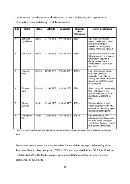
presence was recorded when birds were seen or heard at that site, with opportunistic<br />
observati<strong>on</strong>s recorded during transit between sites.<br />
Site Name Z<strong>on</strong>e Latitude L<strong>on</strong>gitude Distance<br />
from<br />
Settlement<br />
1 Bathurst<br />
Lighthouse<br />
18<br />
Habitat Descripti<strong>on</strong><br />
North 31°59`24"S 115°32`26"E 582m Open grassland near<br />
tennis courts, surrounded<br />
by patchy stands <str<strong>on</strong>g>of</str<strong>on</strong>g><br />
melaleuca, revegetated<br />
acacia, marlock and tuart.<br />
2 The Basin North 31°59`26"S 115°32`15"E 636m Open tuart woodland, with<br />
thick grass and herbaceous<br />
understory, adjoining<br />
dense melaleuca and<br />
calitris stand. Lawn oval<br />
opposite.<br />
3 Peacock<br />
Flats<br />
4 Garden<br />
Lake<br />
5 Bickley<br />
Swamp<br />
6 Thomps<strong>on</strong><br />
Bay<br />
Central 32°00`05"S 115°31`32"E 1539m Low, open acacia swale<br />
with thick shrubby<br />
understory, <strong>on</strong> hill overlooking<br />
salt-lakes. Adjacent<br />
fenced revegetated stand<br />
<str<strong>on</strong>g>of</str<strong>on</strong>g> melaleuca.<br />
Central 31°59`52"S 115°32`13"E 285m Steep rocky hill overlooking<br />
lake, with sparse, low<br />
acacia, and open tuart and<br />
melaleuca woodland to<br />
east.<br />
South 32°00`21"S 115°32`57"E 1392m Dense melaleuca and<br />
calitris woodland with little<br />
understory, becoming open<br />
grassland nearing lake.<br />
South 32°00`11"S 115°32`52"E 1051m Open melaleuca and<br />
acacia woodland <strong>on</strong> sandy<br />
hill, with storm damaged<br />
vegetati<strong>on</strong>. Medium height<br />
with patchy understory.<br />
Table 2.1: Field site locati<strong>on</strong>s and habitat descripti<strong>on</strong> with distance <str<strong>on</strong>g>of</str<strong>on</strong>g> each site from <str<strong>on</strong>g>the</str<strong>on</strong>g> central settlement<br />
area.<br />
These observati<strong>on</strong>s were combined with data from bush bird surveys c<strong>on</strong>ducted by Birds<br />
<str<strong>on</strong>g>Australian</str<strong>on</strong>g> Western Australia group (2007 – 2009) and imported into ArcGIS 9.3 for Windows<br />
(ESIRI Australia Pty. Ltd.) to be mapped against vegetati<strong>on</strong> complexes to assess habitat<br />
preferences <str<strong>on</strong>g>of</str<strong>on</strong>g> bush birds.