

GMSMON-17 WILLISTON RESERVOIR TRIBUTARY - BC Hydro
GMSMON-17 WILLISTON RESERVOIR TRIBUTARY - BC Hydro
GMSMON-17 WILLISTON RESERVOIR TRIBUTARY - BC Hydro

Create successful ePaper yourself
Turn your PDF publications into a flip-book with our unique Google optimized e-Paper software.
2.1.3 Fish Data Analysis<br />
May 22, 2012<br />
Report No. 1114920016-R-Rev0-2000 10<br />
<strong>GMSMON</strong>-<strong>17</strong> <strong>WILLISTON</strong> <strong>RESERVOIR</strong> <strong>TRIBUTARY</strong> HABITAT<br />
REVIEW<br />
Analysis of spawner survey data was simply counts of redds or spawners by site or habitat type.<br />
A hierarchical Bayesian model with habitat strata was proposed in order to estimate abundance of the most<br />
common species from the multiple-pass removal-depletion electrofishing survey. However, very small catches of<br />
all species during the surveys made the proposed analysis and abundance estimates unfeasible. The very low<br />
numbers of fish also did not warrant analyses of life-history characteristics (e.g., length-weight relationships).<br />
Therefore, analysis of electrofishing survey data consisted simply of descriptive summaries of counts of fish<br />
caught by site and creek. Catch-per-unit-effort (CPUE), measured in number of fish per metre of stream length<br />
sampled, was calculated for each creek, combining all sample sites.<br />
2.2 Amphibian Surveys<br />
The amphibian field surveys were completed according to RIC standards (RIC 1998a and 1998b), where<br />
appropriate. Area-based surveys of small ponds and wetlands were completed while at each tributary, and time<br />
effort for each search was documented. Data collected included encounters with amphibian egg masses, larvae<br />
and metamorphs (sub-adults and adults). Data recorded included species identification, sex (where feasible),<br />
developmental stage, and snout-vent length (SVL) (adults only). Identification keys in Corkran and Thoms (1996)<br />
were used to verify identification of egg masses and larvae encountered in the field. Encounters were georeferenced<br />
and photo-documented. A wildlife permit was applied for through the Ministry of Natural Resource<br />
Operations under the Wildlife Act of British Columbia and a permit was obtained on 7 July, 2011 (Permit #PG11-<br />
70683) (copy found in Appendix C).<br />
2.3 Bird Surveys<br />
The survey methods for passerine bird species were adapted from the RIC Inventory Methods for Forest and<br />
Grassland Songbirds (1999) for variable radius point counts. Each creek was used as a transect as it should<br />
reasonably bisect the target habitat (i.e., riparian area) as suggested by Huff et al. (2000) in dealing with the<br />
unique challenges of sampling riparian areas. Point count survey locations were established at 200 m intervals<br />
along the stream with the first location chosen within what is anticipated to be the treatment area. Survey dates<br />
are provided in Table 5.<br />
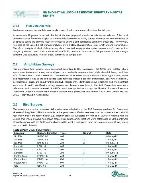
Table 5: Point Count Survey Dates.<br />
Location Stations Sampled Time Round Date<br />
Six Mile SMPC 1-5 AM 1 05-May-11<br />
Six Mile SMPC 1-5 AM 2 13-May-11<br />
Six Mile SMPC 1-5 AM 3 08-June-11<br />
Lamonti LPC 1-5 AM 1 11-May-11<br />
Lamonti LPC 1-5 AM 2 13-May-11<br />
Lamonti LPC 1-5 AM 3 07-June-11<br />
Factor Ross FRPC 1-6 AM 1 15-May-11<br />
Factor Ross FRPC 1-6 PM 2 15-May-11<br />
Factor Ross FRPC 1-2 PM 3 <strong>17</strong>-May-11<br />
Ole OPC 1-8 AM 1 16-May-11


