Locality Analysis - South Gippsland Shire Council
Locality Analysis - South Gippsland Shire Council
Locality Analysis - South Gippsland Shire Council

You also want an ePaper? Increase the reach of your titles
YUMPU automatically turns print PDFs into web optimized ePapers that Google loves.
LOCALITY ANALYSIS STRATEGY VOL. 2 19/9/07<br />
2.2 NYORA<br />
Overview of supply<br />
Nyora’s settlement type is classified as a small town. This assumes that<br />
desirably there would be one major focus for community facilities and sport, but<br />
satellite spaces for social /family recreation may be required because of<br />
geographical layout of township, and barriers created by major road etc.<br />
Nyora is home to over 50% of the population for the Strezelecki Region, and it<br />
has several large parcels of public open space; (such as the recreation reserve<br />
and speedway, the Village Green, the cemetery and the Pony Club site). Open<br />
space and sport and recreation facilities however do not appear to be<br />
developed to serve district or regional markets as in other places such as<br />
Meeniyan and Fish Creek.<br />
The railway reserve provides the core of open space in the town at present,<br />
however the tourist train currently runs through here to Wonthaggi, and<br />
therefore there are some constraints as to how this will be developed and there<br />
are issues with promoting crossing over the track ie to the Recreation Reserve.<br />
The village green with a skate trail and playground appears only partly<br />
developed and could be enhanced by a major redesign and planting program.<br />
It may however need to be relocated as the current site has been ear marked<br />
for the development of a commercial heart.<br />
The newer subdivisions are not well connected to the central hub of sport and<br />
community facilities. Future planning needs to address this.<br />
The range of recreation facilities and their classifications are shown in the<br />
following table.<br />
SOUTH GIPPSLAND SHIRE 9<br />
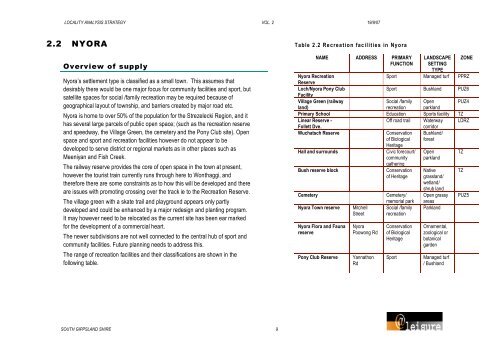
Table 2 .2 Re crea t ion fac ilities in Nyora<br />
NAME ADDRESS PRIMARY<br />
FUNCTION<br />
LANDSCAPE<br />
SETTING<br />
TYPE<br />
ZONE<br />
Nyora Recreation<br />
Reserve<br />
Sport Managed turf PPRZ<br />
Loch/Nyora Pony Club<br />
Facility<br />
Sport Bushland PUZ6<br />
Village Green (railway<br />
Social /family Open PUZ4<br />
land)<br />
recreation parkland<br />
Primary School Education Sports facility TZ<br />
Linear Reserve -<br />
Off road trail Waterway LDRZ<br />
Follett Dve.<br />
corridor<br />
Wuchatsch Reserve Conservation Bushland/<br />
of Biological<br />
Heritage<br />
forest<br />
Hall and surrounds Civic forecourt/ Open TZ<br />
community<br />
gathering<br />
parkland<br />
Bush reserve block Conservation Native TZ<br />
of Heritage grassland/<br />
wetland/<br />
shrub land<br />
Cemetery Cemetery/ Open grassy PUZ5<br />
memorial park areas<br />
Nyora Town reserve Mitchell Social /family Parkland<br />
Street recreation<br />
Nyora Flora and Fauna<br />
reserve<br />
Nyora<br />
Poowong Rd<br />
Pony Club Reserve Yannathon<br />
Rd<br />
Conservation<br />
of Biological<br />
Heritage<br />
Ornamental,<br />
zoological or<br />
botanical<br />
garden<br />
Sport Managed turf<br />
/ Bushland