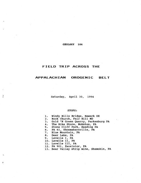
FTELD TRIP ACROSS THE APPALACHTAN OROGENIC BELT
FTELD TRIP ACROSS THE APPALACHTAN OROGENIC BELT
FTELD TRIP ACROSS THE APPALACHTAN OROGENIC BELT

Create successful ePaper yourself
Turn your PDF publications into a flip-book with our unique Google optimized e-Paper software.
GEOIOGY 106<br />
<strong>FTELD</strong> <strong>TRIP</strong> <strong>ACROSS</strong> <strong>THE</strong><br />
<strong>APPALACHTAN</strong> <strong>OROGENIC</strong> <strong>BELT</strong><br />
Saturday, April 30, L994<br />
STOPS:<br />
l-. Windy Hills Bridge, Newark DE<br />
2. Rock Church, Fair Hill l{D<br />
3. Gold 'N Green Quarry, Parkesburg PA<br />
4. The Bike Store, Mohnton, PA<br />
5. Stone Cliff Park, Reading PA<br />
6. PA 61, Shoemakersville, PA<br />
7 . Blue lrtountain, PA<br />
8. Deer Lake, PA<br />
9. Lavelle T, PA<br />
L0. Lavelle If, PA<br />
l-L. Lavelle III, PA<br />
L2. PA 9Ol-, Excelsior, PA<br />
l-3. Bear VaIIey strip mine, Shamokin, PA
FIELD <strong>TRIP</strong> <strong>ACROSS</strong> <strong>THE</strong><br />
APPALACHIAN C)ROGENTC <strong>BELT</strong><br />
April 30, 1,994<br />
Welcome to the Geology 1-06 field trip. Welcome also to GEOL<br />
Ll-O and GEOL 667 and other students. This trip is a group outing,<br />
during which you will see a lot of rocks, learn a lot of new<br />
concepts, cement a lot of faniliar concepts, and make connections<br />
between the o1d concepts and the new ones. This is a trip of<br />
integration, of synthesis, of new awareness. So oi} your mental<br />
engines, sharpen your observation skills, crank up the memory,<br />
clear out your voice to ask questions, and prepare to have a<br />
rocking-good tine.<br />
On the trip you will cross the Appalachian orogenic belt from<br />
one side to the other (well, nearly the other), and you'Il see<br />
representatives of all the najor rock types and structural zones<br />
in the be1t. We'Il make 1.3 stops (if we stay on schedule). We'II<br />
trace the history and evolution of the eastern side of North<br />
America through about 450 mitlion years of earth history, from<br />
late Precanbrian to Jurassic. Ife'11 experience Paleozoic history<br />
in caricature. We'll be able to integrate what we see today with<br />
material from the textbook and the laboratory exercises. By the<br />
end of the day you will have a better, more holistic view of what<br />
an orogenic belt is, and how deposition and deforrnation interplay<br />
to create a mountain range.<br />
A '{ORD ABOUT SAFETY:<br />
There is a DEFII{ITE lfEED on this trip to keep your wits about<br />
you at all tirnes, to TIIII{K SAFtfY at all tines, and to stay alert<br />
when you're off the bus. Most of the outcrops are in road cuts<br />
with active auto and truck traffic, and the rest are along active<br />
railroads or in mines. The need to TIIIIIK fiAFEEY cannot be<br />
overstressed. The roadways are all busy, high-speed ones, and<br />
notorists dontt take kindly to students standing on the actual<br />
driving-Iane pavement rather than on the shoulder. Follow these<br />
two guidelines to the letter, please:<br />
1 . Never ( repeat, NE VER ) step onto the active traf f ic<br />
Ianes. Stay on the shoulders, and preferably behind the<br />
guardrails.<br />
2. Always think ahead; be ahtare of where your next step is<br />
going, make sure that place is firru and safe. Don't jurnp<br />
from rock to rockt step from rock to rock. Never get offbalance;<br />
that's when falIs and twisted ankles happen-
REGTONAL GEOLOGTC SETT TNG<br />
The next several pageq contain maps of the Appalachian<br />
orogenic belt, but no explanatory text; if I wrote a regional<br />
geologic setting there wouldn't be a guidebook at all. Wetl1<br />
discuss these maps on the outcrop, and build the regional setting<br />
as the trip progresses.
;<br />
=rd<br />
L)<br />
rd<br />
; rd<br />
Q,<br />
Qr<br />
o<br />
c,<br />
rd<br />
E<br />
r-l<br />
r!<br />
g<br />
-<br />
P U<br />
=t<br />
p<br />
c:<br />
(]<br />
0.)<br />
..1<br />
qi<br />
...,1<br />
.--{<br />
o,<br />
E<br />
.rl<br />
v)<br />
c\<br />
i,.l<br />
:f<br />
a<br />
H<br />
t!<br />
bt<br />
- ..1<br />
'o<br />
!<br />
0)<br />
-o<br />
(lr<br />
C<br />
o, U)<br />
.-l .rJ U)<br />
UA rdx<br />
!rd<br />
rdc() L<br />
i\<br />
{\ \}L<br />
'o (t' 'n<br />
0.\ -*<br />
d ,a !'n<br />
'O U-l<br />
qro<br />
A, r). t+-t<br />
.J<br />
P !O<br />
ri '.1<br />
r0<br />
a !.c<br />
trA<br />
trr rd t{ o<br />
a<br />
qJ<br />
.o<br />
0)<br />
t{<br />
p l.<br />
o)<br />
O -l '.1 ! OE<br />
:l U .-1 a<br />
.rr .- )1d<br />
u a.dp<br />
FrPC t{ 5r C}<br />
D a' '- ,C: PE<br />
ord14 l-) a o<br />
;i+\I\<br />
r\b.r!<br />
X<br />
V<br />
\
. Varlicot atlta<br />
(hrtlcol .rogsroho r a2.2)<br />
Ftq-o(rc Ll<br />
9 tJ,ienhry l?ool' t F<br />
ft Possirc ho'ri^ LJefta<br />
to 20 30 ao<br />
Xo?irontol rc!la<br />
50 nil..<br />
FoRIltot<br />
E---i]::;:t<br />
h.i..;:lJ<br />
Conglom!rolic<br />
rond!lonr<br />
L , ._-1<br />
l:::.:l<br />
Sondslonr<br />
ffi<br />
[- --_:-]<br />
Silttton!<br />
N<br />
G.oy 5holc<br />
ond nudrocl<br />
- R.d bcds<br />
(ed shole, Ndrcch<br />
siltslona ond<br />
soadtloDc)<br />
PENNSYLVANIAN<br />
SEOUENCE<br />
;ui|i6l!<br />
crilcrxil^trlf,<br />
rourr srror-ftffi<br />
I<br />
Block rholc<br />
FFFH<br />
Lim.dd!<br />
l&i*idl<br />
@<br />
Sondy limc3tonc<br />
EEEtsI<br />
ffi<br />
Colohilr<br />
E;;A<br />
Rock soll<br />
(inct4dcs toma<br />
anhtdrir€ ord<br />
gfqsam)<br />
EXPLANATION<br />
ffi<br />
Bldd.d chlrl<br />
Volconic alolr<br />
E Low flg6<br />
F:ril<br />
lOnad3 ond<br />
htlohorohic 14clt<br />
ot Prriohbrion<br />
bdsamanl coFr{lr<br />
Ohio-W!sl V'rgrnro<br />
boundoTy h6!<br />
a<br />
Chcrl<br />
@<br />
Gtprun<br />
Boundort bctrm rqqenclt<br />
dqshtd ,hn dolo aE bclig<br />
Boundqry b!lw?!n tomtigni<br />
or oroupl<br />
doshcd ,hcrc dolo oE locrrtl<br />
I
{ Wcrf virgr-;o-Vrgito<br />
bocndory li.!<br />
DB<br />
ulsstsstPPtarrt<br />
SEOUENCE<br />
DEVOilIAil<br />
CLASTIG<br />
SEOUEI{CE<br />
LOWER<br />
CAilSRIAN<br />
CLASTIC<br />
SEOUENCE<br />
2 I<br />
I
C*;:;il 't {r<br />
( i:$-*
'ri.<br />
ii'.'.:<br />
:----------{.ti<br />
i-_-v::<br />
-,Zf.<br />
a<br />
rk<br />
I<br />
t= tt<br />
GENERALIZED<br />
GEOLOGIC MAP<br />
OF<br />
SO UT H EAST E RN<br />
PE N NSYLVAN IA<br />
by<br />
A. m. Thompeon<br />
from Pennsylvonio<br />
Stote geologic moP<br />
I<br />
448,55O<br />
I . r I =1. =l_<br />
olo2030<br />
m iles
i'.iii<br />
:iii.'i:j<br />
l3<br />
lz<br />
ll<br />
lo<br />
1<br />
?_-J<br />
.fi;i:.H<br />
I<br />
SCHEMATIC cRoss - sEcTloN<br />
7<br />
g<br />
t
Ll<br />
ALONG LINE A.A<br />
3<br />
ZT A'
STOP 1: h,INDY HILLS BRIDGE<br />
Stop L, 2 and 3 lie in the PIEDIiOilT PROVINCE of Figure L, and<br />
also in the penetrative shear deformation zone of Figure 3. Stops<br />
L and 2 lie east of the zone of niogeosynclinal sedinentation.<br />
The rocks here belong to the JAIIES Rlrlt FORIIATION, of Cambrian<br />
or latest Precambrian age. They are intensely deforne4 and<br />
netanorBhosed, and they are an excellent example of rocks in the<br />
core zone of an orogenic belt. They are strongly layered rocksi<br />
they may have been sedimentary rocks at one timer or they may have<br />
been volcanic rocks, or the layering may have been generated by<br />
the processes of deformation. It's hard to tell.<br />
These rocks are some of the most interesting and puzzling in<br />
De1aware. Delaware contains just a small segiment sf the<br />
Appalachian orogenic belt, running NE across northern New Castle<br />
County. The rocks exposed in Delaware are some of the most<br />
intensely deformed and highest-grade-metanorphic rocks in the<br />
entire Appalachians.<br />
Regardless of whether the rocks were originally sedinentary or<br />
volcanic, they almost certainly originated in an orogenic setting<br />
rather than a cratonic one.<br />
Look for the following features in the rocks:<br />
HfcH-cRADE ilETAIIORPHIC ROCXS: the rocks here are alternating<br />
light and dark gmeisses and schists. The schists contain<br />
abundant mica, and the gneisses contain abundant quartz and<br />
feldspar. firo distlnct varieties of gneisses can be seen.<br />
One is alphibolite, a dark green to black rock. The other is<br />
quartz-feldslnr
4<br />
II{C€I{FOR}IITY: angular unconformity between flat-lying, very<br />
young sediments of the floodplain above, and strongly<br />
deforned, very old, metamorphic rocks beneath. put your hand<br />
on it. 600 nilrion years of earth history are not represented<br />
across that very narrolr boundary.<br />
The sediments above the unconformity represent naterials<br />
belonging to the Atlantic Coastal Plain geologic province.<br />
This outcrop marks the eastern edge of exposure of the<br />
Appalachian orogenic belt.<br />
DEFORI.IATIOT{: folds, faults, ioints, nylonite, and partiat<br />
melting have affected these metanorphic rocks.<br />
Layer-parallel shear, and stretching: Look in the<br />
arnphibolite bands toward the west end of the outcrop and find<br />
thin Iight-colored layers with<br />
within the layers. Look for single, light, coarser grains<br />
that have been rotated and sheared out into very thin white<br />
stringers. These are evidence that there has been intense<br />
shearing and stretching within those layers. Note that the<br />
light layers don't show these featuresi the conclusion is that<br />
the dark layers were weaker than the light ones, and flowed<br />
internally more easily.<br />
Walk to the eastern end of the outcrop, on the knob in the<br />
creek, and observe a beautiful snall fo1d. fs it an anticline<br />
or syncline? How do you know?<br />
observe how the fold has been intnrded by grraFite, One limb<br />
of the fold is largely rnissing. Can you find the other linb?<br />
l{ylonite: Look close below the unconfornity surface and find<br />
dark, Iayered rocks that are folded and contain light<br />
fragrments of other rocks in them. These rocks are nylqnites;<br />
they represent ground-up earlier rocks that were caught in a<br />
fault zone and progressively crushed to fine powder. The<br />
coarse light grains represent pieces of earlier rock that<br />
weren't crushed. The pieces were part of an earlier<br />
pegnatitic granite. The sequence of events here was: shearing<br />
- pegnatite intrusion - more shearing and creation of the<br />
mylonite - folding of the mylonite - more shearing.<br />
Anatexis: look closely at the quartz-feldspar gneiss layers<br />
and find snall places where the delicate, fine layering of the<br />
gneiss disappears and is replaced by slightly coarser grains<br />
with no layering and a massive look. These are places where<br />
the gneiss melted to form snall pockets of granite nagrma. The<br />
process of nelting is called anatexis, and its presence here<br />
indicates that the rocks were very hot (naybe Loo0-L100'F)<br />
and close to nelting during the metanorphism.
There were at<br />
these rocks.<br />
5<br />
least four periods of defornation that affected<br />
STOP 2: ROCK CHURCH<br />
This stop is on private property belonging to Rock<br />
Presbyterian Church. Please be courteous and respectful of the<br />
property.<br />
The rocks exposed here lie in the PIEDIIOIIT PROVIIICE, and again<br />
belong to the JAllES RI|X FOR}iAT.IOil. These rocks are netanorphosed<br />
and deforcued, but are less intensely metarnorphosed tGn those at<br />
Stop L. They consist of anphibolitq gmeiss and schis$. They<br />
contain the dark green minerals chlorite and epidote and amphibole<br />
The parents of these rocks submarine, basalt pill-w lavas that<br />
extruded onto the floor of some former ocean (probably lapetus, or<br />
proto-Atlantic, Ocean). The basalts are probably part of a large<br />
ophiolite complex that was scraped of,f the descending Anerican<br />
plate and eurplaced by thrust faults into its present position.<br />
Other parts of the ophiolite are present in l{aryland, southern<br />
Pennsylvania and northern Virginia. The presence of ophiolite<br />
here indicates that these rocks, and this area, probably went<br />
partway down the subduction zone in the Taconic orogeny.<br />
These rocks have been correlated with the rocks at Windy<br />
Hills, and both belong to the same fonnation. However, the rocks<br />
here are clearly different from those at l{indy Hills: the rock<br />
types are different, the metamorphic Arade ls different, the style<br />
of deformation is different. And there are no fossils. You might<br />
well ask, hory can they be correlative? Ansser: difficult to say.<br />
Probably on the basis of sinilar location relative to other, known<br />
rock bodies. correlation is one of the hardest, nost cornplicated<br />
tasks in all of geology.<br />
Features to observe at this exposure include:<br />
defoned Dil1os strugtures: Look low on the front wall, in<br />
the nassive (unlayered) central portion, and you can nake out<br />
elongated, flattened zones defined by darker, thin (L-2 cr),<br />
finer-grained rins. The pillows are maybe 1o-5o cm in long<br />
dinension, and are flattened by the defornation. They are<br />
difficult to see at best, and may be invisible today.<br />
Features of the original lava: vesicles : small (1 nn) gasbubble<br />
holes, where gas bubbled out of the lave when it<br />
extruded. They are filled with white minerals now, and are<br />
easily visible. They are defoned, into elongate, pencil-like<br />
shapes, and give the rock a distinct linear appearance.<br />
Fo1ds: The rocks have folded several times, and you can find<br />
fold axea, fold linbs, and different geonetric shapes of
folds.<br />
PodF of ouart? and feldspar: there are large masses of quartz<br />
and feldspar in the rocks. I'm not sure what their origrin is,<br />
or why they're here<br />
Joints: find the long, straight, regularly spaced, nearly<br />
vertical fractures that cut all the rocks. These fractures<br />
are called joints. They formed later than the folding<br />
defornation, because they cut all the folds and are not<br />
affected by the folds.
STOP 3: G()LD<br />
7<br />
, N GREEN CIUARRY, PARKESBURG<br />
This stop is in a privately owned quarryrand ere are here by<br />
the good graces of the owners (one is a UD grad). please respect<br />
the property and its contents. DO. NOT ENTER <strong>THE</strong> DEEP PIT TO <strong>THE</strong><br />
RE,AR RIGHT; STAY ON <strong>THE</strong> HIGHER GROUND TO <strong>THE</strong> REAR LEFT.<br />
The rocks here are stil-I within the PIEDIIOIIT province, because<br />
they show penetrative shear deformation (see Figure 3). They are<br />
on the margin of a large anticline that exposes Precanbrian<br />
basement rocks in the center. However, they are ;rart of the<br />
niogeosynclinal, passive-nargin wedge (Figure 3). They belong to<br />
the CHICKIES FORIIATIOI{, of latest Precambrian age.<br />
The Chickies is a quartzite and netagongl,olerate, a sequence<br />
of quartz sandstones and quartz-pebble conglomerates that have<br />
undergone high-grade metamorphism. The parents of quartzite<br />
clearly are sedinentary sandstones. Thls particular sandstone was<br />
clean, mature and well-sorted when deposited, with little clay<br />
matrix. During metamorphism there wasn't much in the rock besides<br />
quartz Lo make new metarnorphic minerals, and the quartzite has the<br />
same minerals as the original sandstone (although grain shapes are<br />
clearly metamorphic).<br />
The cleanness and maturity of the original sandstone suggests<br />
a cratonic tectonic setting of deposition, even though the rock<br />
came into an orogenic-subduction zone later in its history. The<br />
Chickies is the basal, lowest rock unit in the oassive uargin<br />
wedge of sedimentary rocks that developed on the eastern margin of<br />
North America during Late Precanbrian through Middle Ordovician<br />
time (see Figure 4). The sand was produced by weathering of<br />
craton and basement rocks to the north and northwest, in Canada<br />
and the US midwest. Remember the Taconic Orogeny laboratory? The<br />
Chickies is sinilar to the sandstone facies on the Upper Cambrian<br />
map of that exercise. This sequence of rocks developed on the<br />
trailing edge of what was the rrAmericantf plate of that time.<br />
After the plate motion reversed in ruiddle Ordovician tirne, this<br />
trailing edge became the leading edge, and the eastern parts of<br />
the passive-nargin wedge were partially subducted, metamorphosed<br />
and deformed. Thus the Chickies.<br />
Features to observe at this outcrop include:<br />
strong, parallg,Lbgkligg in the quartzites.<br />
made more parallel by the metamorphism.<br />
It was probably<br />
Look for eross-beddingr in the sandstones. It might be<br />
visible, might not be. took for truncation of bed contacts by<br />
other beds, Iook for T-junctions.
Which way do the rocks dip? (You are facing east).<br />
8<br />
Which way would you drive to find ol4er rocks? younger rocks?<br />
Which way to the anticline? to the EEsLine?<br />
This quarry is a veritable gold urine of interesting inported<br />
rock typesi we could spend the whole day here. Notice<br />
especially the<br />
coarse-grained red s-andstone: we'I} see more of that the<br />
next stop. Jurassic, from the rift basin.<br />
dark gray, coarse-grained ggbbre: the coarse-grained,<br />
intrusive equivalent of basalt. An igneous rock - look at<br />
the crystals and the difference between its texture and<br />
the sandstonets. Jurassic, from the rift basin.
STOP 4:<br />
9<br />
<strong>THE</strong> BIKE STORE', MOHNTON<br />
The vacant lot just beyond the Harley-Davidson shop can be<br />
soft and wet, and you need to be careful to stick to the higher<br />
ground. Stay away from the highway, because itts a blind curve<br />
with high-speed traffic.<br />
This site is located within the IIESOZOIC RIFT BASIil (labelled<br />
rrTriassictr on Figure L ) that runs continuously from New York state<br />
to Virginia. The basins are of Late Triassic and Early Jurassic<br />
n9€r are younger than anything in the Appalachian orogenic be1t,<br />
and are not genetically related to Appalachian events in any way.<br />
The Appalachian orogenic belt involved compressive deformation and<br />
shortening of the earth's crust; the Mesozoic rift basins involved<br />
extensional deformation and lengthening of the crust. The<br />
extension is related to the breqlsup of Pangea - the rifting apart<br />
of the supercontinent of Pangea in early l.lesozoic tine. This rift<br />
basin is one (of rnany) early, failed attenpts at breakup; the new<br />
Atlantic Ocean didn't open up here, but opened later farther east,<br />
and preserved this basin on the segnent of continent that drifted<br />
west from the nid-Atlantic ridge. This rift basin was a<br />
precursor of the new Atlantic ocean.<br />
The rift basin has a wedge shape, thickest on the north edge<br />
and thinningr to zero on the south edge. The sedimentary strata<br />
dip to the north. Look across the highway to the north; the ridge<br />
on the skyline is the north edge of the basin. The north edge is<br />
marked by a norrnal f4ult, in which the south side, our side, yras<br />
dropped down. The high lands on the upthrown side were subjected<br />
to intense erosion, and generated coarse sand and gravel sediment<br />
that becarne the sandstones and conglomerates of this outcrop. The<br />
skyline ridge to the north is underlain by older rocks that were<br />
the very source for the pebbles in this conglomerate.<br />
The rift basin contaLns two rnajor kinds of rock: terrigenous,<br />
red, clastic sedinentary rocks ranging fron shale to sandstone and<br />
conglomerate, and intrusive igneous rocks of gabbro composition<br />
(that we saw at the previous stop). The rocks here are cobble and<br />
boulder corxrlorcrates and cq?rse:grrained rFd sandstones.<br />
observe in these rocks:<br />
the in the conglomerates, Are<br />
they snooth or angUlAr? Are they sorted into beds of sinilar<br />
clast sizer oF are they rlnsorted and mixed together regardless<br />
of size?<br />
How far alray (relatively) is this location from the source of
these sedirnents?<br />
1_O<br />
Look at the matrix between the pebbles, i,e. the sandstone.<br />
Is it well sorted or poorly sorted?<br />
Which way do the rocks dip? north or south? toward the fault<br />
or away from the fault,?<br />
When wetre done looking at the rocks, you can visit the bike<br />
store for a minute. T-shirt time.
11<br />
STOP 5: STONE CLIFF PARK, READ I NG<br />
PfT STOP, LLTNCH STOP - Eat tunch first,<br />
Iook.at the rocks. l{O IIAtll{ERS PtEjtSE; this is a city park.<br />
then<br />
The rocks here are limestirnes and dolonites of the<br />
Conochocheague Fornation, of upper Cambrian age. These rocks are<br />
part of the passive margin wedge of the early Paleozoic eastern<br />
margin of North America (see Figure 4), and were deposited in a<br />
cratonic tectonic setting. These rocks are typical of cratonicsetting<br />
deposition: Iittle to no terrigenous clastic sediment, ro<br />
quartz sandstones, shallow-water deposition, lots of fossils.<br />
There was little to no uplift of any source arear Do sediment from<br />
outside the area of deposition, and the carbonate sediment for<br />
these limestones came prinarily from the breakdown of animal and<br />
plant skeletons close to the site of deposition.<br />
The rocks contain many interesting features related to<br />
carbonate deposition. Look for the following features as you<br />
examine the rocks:<br />
interbedded linestone and dolonite: the gray beds and<br />
lanination are linestone, and the buff to tan lanination are<br />
dolonite. Limestone is made up of calcite, whose formula is<br />
CaCO' whereas dolomite the rock is made up of the mineral<br />
dolomite, CaMg(Cor)r. The dolonite beds contain more magnesium<br />
than the lirnestone beds. Both are very-fine-grained; the<br />
particles are clay size. Fine-grained, clay-size carbonate<br />
rocks of any composition are lunped into the term uicrite.<br />
The magnesium was concentrated in the locations now occupied<br />
by dolornite by the actions of blue-green algae, which grew as<br />
. mats and sliury coverings over beds of calcite. The resulting<br />
interlayered calcite/dolomite bedding is actually considered a<br />
fossil (= any evidence of prehistoric life), and is called a<br />
stromatolite. This particular expression of stromatolite is<br />
stromatol-itic layering, or crlTrtalgal lanination.<br />
Another expression of stromatolite is seen in the little<br />
reentrant just north of the spur. There, you can see<br />
stromatolitic layering arranged in isolated columns and<br />
separated by buff dolourite. These are donal or colrunar<br />
stromatolites. These were domes and protruberances on the sea<br />
floor that were capped by algal mat and were eroded on either<br />
side by currents.<br />
Modern stromatolites are confined in their occurrence to<br />
Iocations away from terrigenous sediment input and to the<br />
intertidal zone, between high and low tides. There is no<br />
reason discovered so far to doubt that ancient stromatolites<br />
can be interpreted the same vtay. Thus, stromatolites are
L2<br />
useful in establishing ancient sea level positions. yourre<br />
looking here at part of a 520-million-year-otd tidal shoreline<br />
conplex. If you listen closely, you can hear the surf, and<br />
with imagination you can see the beach umbrellas.<br />
Look for beds of medium-blue-gray rock, especially near the<br />
playground. These rocks are ooliter or oolitic linestone.<br />
Oolite contains nearly spherical, sand-size grains of calcite<br />
(ooids) that you can see with good eyes or a hand lens. The<br />
ooids grew to sand size as small specks of earlier minerals<br />
r'fere progressively coated with calcite as they rolled around<br />
on the sea floor in response to current flow. Oolite is a<br />
clastic rock, but is not. terrigenous. Oolite often occurs in<br />
association with stromatolite, and represents current flow<br />
resulting from tidal rise and faII on the tidal flats where<br />
the alga1 mats lived.<br />
The oolitic sandstones show cross-bedding and riople narks,<br />
features you would expect in traction-transported sediment.<br />
The rocks have undergone deformation, during the Alleghanian<br />
orogeny in the Pennsylvanian and Permian. Several nutually<br />
incompatible kinds of defornation are present:<br />
Look for short, 1-0-50 cm veins filled with white calcite.<br />
These are tension gash veins. They indicate that the rock has<br />
been pu1led apart, put under tension, in a direction normal<br />
to the veins. So the rock has been stretched.<br />
Look for stylolitesr up close and personal. Stylolites are<br />
tiny, clay-Iined discontinuities in the rock, that are fairly<br />
rare and are oriented usually normal to bedding. They<br />
represent places where calcite has been dissolved and removed<br />
from the rock. The dissolving occurs during compression, and<br />
the stylolites develop normal to the compression direction.<br />
So the rock has been compressed.<br />
Look for dip and strikg of bedding - the rock layers are<br />
inclined, and dip to the south.<br />
Look for cleavagre - a parallel splitting property that cuts<br />
across bedding. Cleavage forms during folding, and grows<br />
parallel to the axial planes of the folds. Cleavage usually<br />
has a different dip than the bedding. The cleavage here dips<br />
steeper than bedding, and from the relative dips of cleavage<br />
and bedding you can figure out which linlc of the fold these<br />
rocks are on<br />
Tensional and compressive deformation clearly cannot affect a<br />
rock at the same time and place; they are nutually exclusive.<br />
So the deformation must have been in a sequence of pulses.
1_3<br />
Work out a sequence of eyents in the formation of these rocks.<br />
Just like you did in class and lab.
L4<br />
STOP 5: PA 61 , SHOEMAKERSV f LLE<br />
cAUTION: This land is privately owned, and the owner is<br />
worried about liability. YOU