Catalog PDF - Mapmedia
Catalog PDF - Mapmedia
Catalog PDF - Mapmedia
- TAGS
- catalog
- mapmedia
- mapmedia.com

You also want an ePaper? Increase the reach of your titles
YUMPU automatically turns print PDFs into web optimized ePapers that Google loves.
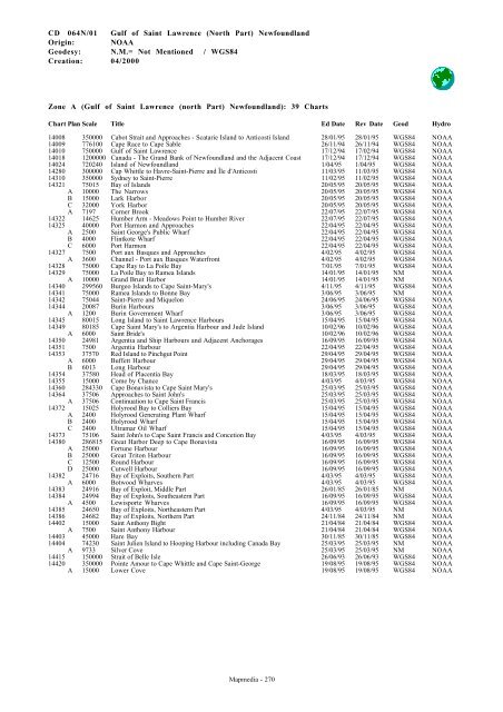
CD 064N/01 Gulf of Saint Lawrence (North Part) Newfoundland<br />
Origin: NOAA<br />
Geodesy: N.M.= Not Mentioned / WGS84<br />
Creation: 04/2000<br />
Zone A (Gulf of Saint Lawrence (north Part) Newfoundland): 39 Charts<br />
Chart Plan Scale Title Ed Date Rev Date Geod Hydro<br />
14008 350000 Cabot Strait and Approaches - Scatarie Island to Anticosti Island 28/01/95 28/01/95 WGS84 NOAA<br />
14009 776100 Cape Race to Cape Sable 26/11/94 26/11/94 WGS84 NOAA<br />
14010 750000 Gulf of Saint Lawrence 17/12/94 17/02/94 WGS84 NOAA<br />
14018 1200000 Canada - The Grand Bank of Newfoundland and the Adjacent Coast 17/12/94 17/12/94 WGS84 NOAA<br />
14024 720240 Island of Newfoundland 1/04/95 1/04/95 WGS84 NOAA<br />
14280 300000 Cap Whittle to Havre-Saint-Pierre and Île d'Anticosti 11/03/95 11/03/95 WGS84 NOAA<br />
14310 350000 Sydney to Saint-Pierre 11/02/95 11/02/95 WGS84 NOAA<br />
14321 75015 Bay of Islands 20/05/95 20/05/95 WGS84 NOAA<br />
A 10000 The Narrows 20/05/95 20/05/95 WGS84 NOAA<br />
B 15000 Lark Harbor 20/05/95 20/05/95 WGS84 NOAA<br />
C 32000 York Harbor 20/05/95 20/05/95 WGS84 NOAA<br />
A 7197 Corner Brook 22/07/95 22/07/95 WGS84 NOAA<br />
14322 14625 Humber Arm - Meadows Point to Humber River 22/07/95 22/07/95 WGS84 NOAA<br />
14325 40000 Port Harmon and Approaches 22/04/95 22/04/95 WGS84 NOAA<br />
A 2500 Saint George's Public Wharf 22/04/95 22/04/95 WGS84 NOAA<br />
B 4000 Flintkote Wharf 22/04/95 22/04/95 WGS84 NOAA<br />
C 6000 Port Harmon 22/04/95 22/04/95 WGS84 NOAA<br />
14327 7500 Port aux Basques and Approaches 4/02/95 4/02/95 WGS84 NOAA<br />
A 3600 Channel - Port aux Basques Waterfront 4/02/95 4/02/95 WGS84 NOAA<br />
14328 75000 Cape Ray to La Poile Bay 7/01/95 7/01/95 WGS84 NOAA<br />
14329 75000 La Poile Bay to Ramea Islands 14/01/95 14/01/95 NM NOAA<br />
A 10000 Grand Bruit Harbor 14/01/95 14/01/95 NM NOAA<br />
14340 299560 Burgeo Islands to Cape Saint-Mary's 4/11/95 4/11/95 WGS84 NOAA<br />
14341 75000 Ramea Islands to Bonne Bay 3/06/95 3/06/95 NM NOAA<br />
14342 75044 Saint-Pierre and Miquelon 24/06/95 24/06/95 WGS84 NOAA<br />
14344 20087 Burin Harbours 3/06/95 3/06/95 WGS84 NOAA<br />
A 1200 Burin Government Wharf 3/06/95 3/06/95 WGS84 NOAA<br />
14345 80015 Long Island to Saint Lawrence Harbours 15/04/95 15/04/95 WGS84 NOAA<br />
14349 80185 Cape Saint Mary's to Argentia Harbour and Jude Island 10/02/96 10/02/96 WGS84 NOAA<br />
A 6000 Saint Bride's 10/02/96 10/02/96 WGS84 NOAA<br />
14350 24981 Argentia and Ship Harbours and Adjacent Anchorages 16/09/95 16/09/95 WGS84 NOAA<br />
14351 7500 Argentia Harbour 22/04/95 22/04/95 WGS84 NOAA<br />
14353 37570 Red Island to Pinchgut Point 29/04/95 29/04/95 WGS84 NOAA<br />
A 6000 Buffett Harbour 29/04/95 29/04/95 WGS84 NOAA<br />
B 6013 Long Harbour 29/04/95 29/04/95 WGS84 NOAA<br />
14354 37580 Head of Placentia Bay 18/03/95 18/03/95 WGS84 NOAA<br />
14355 15000 Come by Chance 4/03/95 4/03/95 WGS84 NOAA<br />
14360 284330 Cape Bonavista to Cape Saint Mary's 25/03/95 25/03/95 WGS84 NOAA<br />
14364 37506 Approaches to Saint John's 25/03/95 25/03/95 WGS84 NOAA<br />
A 37506 Continuation to Cape Saint Francis 25/03/95 25/03/95 WGS84 NOAA<br />
14372 15025 Holyrood Bay to Colliers Bay 15/04/95 15/04/95 WGS84 NOAA<br />
A 2400 Holyrood Generating Plant Wharf 15/04/95 15/04/95 WGS84 NOAA<br />
B 2400 Holyrood Wharf 15/04/95 15/04/95 WGS84 NOAA<br />
C 2400 Ultramar Oil Wharf 15/04/95 15/04/95 WGS84 NOAA<br />
14373 75106 Saint John's to Cape Saint Francis and Concetion Bay 4/03/95 4/03/95 WGS84 NOAA<br />
14380 286815 Great Harbor Deep to Cape Bonavista 16/09/95 16/09/95 WGS84 NOAA<br />
A 25000 Fortune Harbour 16/09/95 16/09/95 WGS84 NOAA<br />
B 25000 Great Triton Harbour 16/09/95 16/09/95 WGS84 NOAA<br />
C 12500 Round Harbour 16/09/95 16/09/95 WGS84 NOAA<br />
D 25000 Cutwell Harbour 16/09/95 16/09/95 WGS84 NOAA<br />
14382 24716 Bay of Exploits, Southern Part 4/03/95 4/03/95 WGS84 NOAA<br />
A 6000 Botwood Wharves 4/03/95 4/03/95 WGS84 NOAA<br />
14383 24916 Bay of Exploit, Middle Part 26/01/85 26/01/85 NM NOAA<br />
14384 24994 Bay of Exploits, Southeastern Part 16/09/95 16/09/95 WGS84 NOAA<br />
A 4500 Lewisporte Wharves 16/09/95 16/09/95 WGS84 NOAA<br />
14385 24650 Bay of Exploits, Northeastern Part 4/03/95 4/03/95 NM NOAA<br />
14386 24682 Bay of Exploits, Northern Part 24/11/84 24/11/84 NM NOAA<br />
14402 15000 Saint Anthony Bight 21/04/84 21/04/84 WGS84 NOAA<br />
A 7500 Saint Anthony Harbour 21/04/84 21/04/84 WGS84 NOAA<br />
14403 45000 Hare Bay 30/11/85 30/11/85 WGS84 NOAA<br />
14404 74230 Saint Julien Island to Hooping Harbour including Canada Bay 25/03/95 25/03/95 NM NOAA<br />
A 9733 Silver Cove 25/03/95 25/03/95 NM NOAA<br />
14415 150000 Strait of Belle Isle 26/06/93 26/06/93 WGS84 NOAA<br />
14420 350000 Pointe Amour to Cape Whittle and Cape Saint-George 19/08/95 19/08/95 WGS84 NOAA<br />
A 15000 Lower Cove 19/08/95 19/08/95 WGS84 NOAA<br />
<strong>Mapmedia</strong> - 270