Catalog PDF - Mapmedia
Catalog PDF - Mapmedia
Catalog PDF - Mapmedia
- TAGS
- catalog
- mapmedia
- mapmedia.com

You also want an ePaper? Increase the reach of your titles
YUMPU automatically turns print PDFs into web optimized ePapers that Google loves.
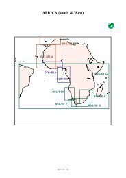
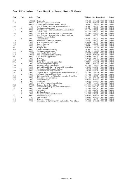
Zone B(West Ireland - From Limerik to Donegal Bay) : 30 Charts<br />
Chart Plan Scale Title Ed Date Rev Date Geod Hydro<br />
2 1500000 British Isles 10/05/01 16/10/02 WGS 84 UKHO<br />
1125 500000 Western Approaches to Ireland 11/01/85 26/09/02 WGS 84 UKHO<br />
1127 500000 Outer Approaches to the North Channel 5/02/93 12/09/02 WGS 84 UKHO<br />
1540 12500 River Shannon - Shannon Airport to Limerick 5/01/81 1/02/02 WGS 84 UKHO<br />
A 12500 Continuation of the chart 5/01/81 1/02/02 WGS 84 UKHO<br />
1547 20000 River Shannon - Kilcredaun Point to Ardmore Point 19/11/93 5/04/02 WGS 84 UKHO<br />
A 10000 Kilrush Creek 19/11/93 5/04/02 WGS 84 UKHO<br />
1548 20000 River Shannon - Ardmore Point to Rinealon Point 19/12/86 18/09/02 WGS 84 UKHO<br />
1549 20000 River Shannon - Rinealon Point to Shannon Airport 7/06/01 3/07/02 WGS 84 UKHO<br />
including Foynes Harbour<br />
A 7500 Foynes Harbour 7/06/01 3/07/02 WGS 84 UKHO<br />
1819 50000 Approaches to the River Shannon 7/12/79 4/09/02 WGS 84 UKHO<br />
1820 75000 Aran Islands to roonah Head 30/03/84 1/01/02 WGS 84 UKHO<br />
1903 10000 Galway Harbour 3/09/98 6/02/02 WGS 84 UKHO<br />
1984 30000 Galway Bay 5/02/93 14/12/01 WGS 84 UKHO<br />
2057 15000 Westport Bay 20/03/81 31/08/02 WGS 84 UKHO<br />
2096 30000 Cashla Bay to Kilkieran Bay 1/01/81 21/08/02 WGS 84 UKHO<br />
A 30000 Continuation of the chart 1/01/81 21/08/02 WGS 84 UKHO<br />
2173 150000 Loop Head to Slyne Head 13/07/84 8/07/02 WGS 84 UKHO<br />
2420 150000 Aran Islands to Broad Haven Bay 13/07/84 26/09/02 WGS 84 UKHO<br />
2667 50000 Clew Bay and approaches 18/02/83 3/08/02 WGS 84 UKHO<br />
A 25000 Newport 18/02/83 3/08/02 WGS 84 UKHO<br />
2702 60000 Donegal Bay 26/10/79 19/07/02 WGS 84 UKHO<br />
2703 50000 Broad Haven Bay and approaches 8/02/80 16/04/02 WGS 84 UKHO<br />
A 15000 Portnafrankagh (Frenchport) 8/02/80 16/04/02 WGS 84 UKHO<br />
2704 50000 Blocksod Bay and approaches 20/11/81 22/09/01 WGS 84 UKHO<br />
2706 25000 Ballynakill and Killary Harbours with approaches 14/05/82 6/10/01 WGS 84 UKHO<br />
A 25000 Continuation of Ballynakill Harbour 14/05/82 6/10/01 WGS 84 UKHO<br />
2706 B 25000 Continuation of Killary Harbour 14/05/82 6/10/01 WGS 84 UKHO<br />
2707 25000 Kingston Bay to Cleggan Bay and Inishbofin to Inishturk 18/11/83 15/07/00 WGS 84 UKHO<br />
A 25000 Continuation of Streamstown Bay 18/11/83 15/07/00 WGS 84 UKHO<br />
2708 25000 Ballyconneely Bay to Clifden Bay including Slyne Head 18/11/83 5/05/01 WGS 84 UKHO<br />
2709 30000 Roundstone and approaches 18/11/83 15/03/02 WGS 84 UKHO<br />
2715 A 15000 Donegal Harbour 29/07/77 19/10/01 WGS 84 UKHO<br />
B 25000 Killala Bay 29/07/77 19/10/01 WGS 84 UKHO<br />
C 25000 River Moy - continuation to Balina 29/07/77 19/10/01 WGS 84 UKHO<br />
2725 200000 Blacksod Bay to Tory Island 28/10/99 21/03/02 WGS 84 UKHO<br />
2767 75000 Porturlin to Sligo Bay and Rathlin O'Birne Island 14/12/79 9/01/01 WGS 84 UKHO<br />
2792 A 10000 Teelin Harbour 31/12/81 6/08/01 WGS 84 UKHO<br />
B 10000 Church Pool 31/12/81 6/08/01 WGS 84 UKHO<br />
C 12500 Killybegs Harbour 31/12/81 6/08/01 WGS 84 UKHO<br />
D 15000 The Sound of Aran and Burtonport 31/12/81 6/08/01 WGS 84 UKHO<br />
2852 20000 Approaches to Sligo 29/05/87 30/09/02 WGS 84 UKHO<br />
A 12500 Sligo Harbour 29/05/87 30/09/02 WGS 84 UKHO<br />
3338 50000 Kilkee to Inisheer 18/04/80 1/01/02 WGS 84 UKHO<br />
3339 50000 Approaches to the Galway Bay includind the Aran Islands 11/12/81 15/05/02 WGS 84 UKHO<br />
<strong>Mapmedia</strong> - 42