Catalog PDF - Mapmedia
Catalog PDF - Mapmedia
Catalog PDF - Mapmedia
- TAGS
- catalog
- mapmedia
- mapmedia.com

You also want an ePaper? Increase the reach of your titles
YUMPU automatically turns print PDFs into web optimized ePapers that Google loves.
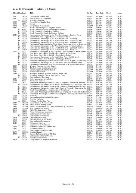
Zone B (Weymouth - Calais): 34 Charts<br />
Chart Plan Scale Title Ed Date Rev Date Geod Hydro<br />
323 75000 Dover Strait Eastern Part 1/09/97 11/10/00 WGS84 UKHO<br />
536 75000 Beachy Head to Dungeness 1/01/93 1/01/00 WGS84 UKHO<br />
A 15000 Sovereign Harbour 1/01/93 1/01/00 WGS84 UKHO<br />
1652 75000 Selsey Bill to Beachy Head 17/03/89 1/01/00 WGS84 UKHO<br />
1698 6250 Dover 1/06/98 1/01/00 WGS84 UKHO<br />
1892 75000 Dover Strait Western Part 31/08/00 16/10/00 WGS84 UKHO<br />
1991 A 5000 South Coast of England - Brighton Marina 1/01/00 6/06/00 WGS84 UKHO<br />
B 6250 South Coast of England - Littlehampton Harbour 1/01/00 6/06/00 WGS84 UKHO<br />
C 25000 South Coast of England - Rye Harbour 1/01/00 6/06/00 WGS84 UKHO<br />
D 5000 South Coast of England - Folkestone Harbour 1/01/00 6/06/00 WGS84 UKHO<br />
2021 A 10000 Harbours and Anchorages in the West Solent Area - Beaulieu River 1/12/91 18/10/00 WGS84 UKHO<br />
B 10000 West Solent Area - Upper Reaches of Beaulieu River 1/12/91 18/10/00 WGS84 UKHO<br />
C 10000 Harbours and Anchorages in the West Solent Area - Alum Bay 1/12/91 18/10/00 WGS84 UKHO<br />
D 5000 Harbours and Anchorages in the West Solent Area - Freshwater Bay 1/12/91 18/10/00 WGS84 UKHO<br />
E 12500 Harbours and Anchorages in the West Solent Area - Newtown River 1/12/91 18/10/00 WGS84 UKHO<br />
F 7500 Harbours &Anchorages in the West Solent Area-Approaches to Keyhaven 1/12/91 18/10/00 WGS84 UKHO<br />
G 5000 Harbours and Anchorages in the West Solent Area - Lymington River 1/12/91 18/10/00 WGS84 UKHO<br />
H 3000 Harbours and Anchorages in the West Solent Area - Yarmouth Harbour 1/12/91 18/10/00 WGS84 UKHO<br />
I 12500 Harbours and Anchorages in the West Solent Area - River Yar 1/12/91 18/10/00 WGS84 UKHO<br />
2022 A 5000 Harbours & Anchorages in the East Solent Area-Entrance to River Hamble 1/12/98 26/10/00 WGS84 UKHO<br />
B 5000 East Solent Area - River Hamble - Port Hamble to Bursledon 1/12/98 26/10/00 WGS84 UKHO<br />
C 25000 East Solent Area - River Hamble - Bursledon to Botley 1/12/98 26/10/00 WGS84 UKHO<br />
D 10000 Harbours and Anchorages in the East Solent Area - Ashlett Creek 1/12/98 26/10/00 WGS84 UKHO<br />
E 5000 East Solent Area - Isle of Wight - Bembridge Harbour 1/12/98 26/10/00 WGS84 UKHO<br />
F 20000 Harbours &Anchorages in East Solent Area - Isle of WighT-Sandown Bay 1/12/98 26/10/00 WGS84 UKHO<br />
G 3000 Harbours and Anchorages in the East Solent Area - Hillhead Harbour 1/12/98 26/10/00 WGS84 UKHO<br />
H 10000 Harbours & Anchorages East Solent Area-Isle of Wight-Wootton Creek 1/12/98 26/10/00 WGS84 UKHO<br />
2035 25000 Western Approaches to the Solent 21/09/00 2/11/00 WGS84 UKHO<br />
2036 25000 The Solent and Southampton Water 21/09/00 6/11/00 WGS84 UKHO<br />
2037 25000 Eastern Approaches to the Solent 21/09/00 12/10/00 WGS84 UKHO<br />
2041 10000 Port of Southampton 21/09/00 25/10/00 WGS84 UKHO<br />
2044 A 5000 Shoreham Harbour Western Arm and River Adur 1/02/95 3/07/00 WGS84 UKHO<br />
B 5000 Shoreham Harbour Eastern Arm and the Canal 1/02/95 3/07/00 WGS84 UKHO<br />
C 15000 Approaches to Shoreham 1/02/95 3/07/00 WGS84 UKHO<br />
2045 75000 Outer approaches to the Solent 1/10/90 17/10/00 WGS84 UKHO<br />
2154 5000 Newhaven Harbour 23/02/96 10/05/00 WGS84 UKHO<br />
2172 A 7500 Harbours& Anchorages onSouth Coast of England-Christchurch Harbour 1/02/97 12/07/00 WGS84 UKHO<br />
B 12500 Harbours and Anchorages on the South Coast of England - Chapman's Pool 1/02/97 12/07/00 WGS84 UKHO<br />
C 5000 Harbours and Anchorages on the South Coast of England - Lulworth Cove 1/02/97 12/07/00 WGS84 UKHO<br />
D 12500 Harbours and Anchorages on the South Coast of England - Worbarrow Bay1/02/97 12/07/00 WGS84 UKHO<br />
E 7500 South Coast of England - Continuation of River Stour 1/02/97 12/07/00 WGS84 UKHO<br />
F 5000 Harbours& Anchorages on the South Coast of England-Weymouth Harbour1/02/97 12/07/00 WGS84 UKHO<br />
G 12500 Harbours& Anchorages, South Coast of England - Swanage&Studland Bays1/02/97 12/07/00 WGS84 UKHO<br />
2175 20000 Poole Bay 1/08/99 11/07/00 WGS84 UKHO<br />
2255 20000 Approaches to Portland and Weymouth 1/06/98 3/11/00 WGS84 UKHO<br />
2268 10000 Portland Harbour 1/06/98 6/11/00 WGS84 UKHO<br />
A 5000 Portland Port Berthing Plan 1/06/98 6/11/00 WGS84 UKHO<br />
2449 150000 Dover Strait to Westerschelde 1/02/98 23/10/00 WGS84 UKHO<br />
2450 150000 Anvil Point to Beachy Head 1/05/91 21/10/00 WGS84 UKHO<br />
2451 150000 Newha Ven to Dover and Cap d'Antifer to Cap Gris-Nez 30/12/99 2/09/00 WGS84 UKHO<br />
2454 150000 Start Point to The Needles 14/02/92 25/08/00 WGS84 UKHO<br />
2610 40000 Bill of Portland to Anvil Point 1/06/98 3/11/00 WGS84 UKHO<br />
2611 12500 Poole Harbour and approaches 1/04/98 12/07/00 WGS84 UKHO<br />
A 12500 Continuation of Holes Bay 1/04/98 12/07/00 WGS84 UKHO<br />
B 12500 Continuation to Wareham 1/04/98 12/07/00 WGS84 UKHO<br />
2613 154200 Cherbourg to Fécamp 1/08/98 22/09/00 WGS84 UKHO<br />
2615 75000 Bill of Portland to the Needles 1/12/87 2/11/00 WGS84 UKHO<br />
2625 7500 Approaches to Portsmouth 1/07/98 20/10/00 WGS84 UKHO<br />
2628 5000 Portsmouth Harbour 1/12/98 31/08/00 WGS84 UKHO<br />
A 5000 Continuation to Port Solent 1/12/98 31/08/00 WGS84 UKHO<br />
2629 5000 Portsmouth Harbour Southern Part 1/12/98 17/10/00 WGS84 UKHO<br />
2631 7500 Porsmouth Harbour 1/12/98 31/08/00 WGS84 UKHO<br />
A 7500 Continuation to Fareham lake 1/12/98 31/08/00 WGS84 UKHO<br />
2675 500000 English Channel 11/11/99 1/01/00 WGS84 UKHO<br />
2793 3500 Cowes Harbour and River Medina 1/12/97 20/10/00 WGS84 UKHO<br />
A 3500 Continuation Of River Medina 1/12/97 20/10/00 WGS84 UKHO<br />
B 10000 Folly Point to Newport 1/12/97 20/10/00 WGS84 UKHO<br />
3418 20000 Langstone and Chichester Harbours 1/12/89 9/10/00 WGS84 UKHO<br />
<strong>Mapmedia</strong> - 30