Catalog PDF - Mapmedia
Catalog PDF - Mapmedia
Catalog PDF - Mapmedia
- TAGS
- catalog
- mapmedia
- mapmedia.com

You also want an ePaper? Increase the reach of your titles
YUMPU automatically turns print PDFs into web optimized ePapers that Google loves.
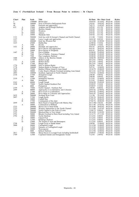
Zone C (North&East Ireland - From Rossan Point to Arklow) : 36 Charts<br />
Chart Plan Scale Title Ed Date Rev Date Geod Hydro<br />
2 1500000 British Isles 10/05/01 16/10/02 WGS 84 UKHO<br />
44 100000 Nose of Howth to Ballyquintin Point 1/02/01 19/02/02 WGS 84 UKHO<br />
49 15000 Portrush and approaches 7/02/75 12/02/02 WGS 84 UKHO<br />
633 A 15000 Ardglass and Killough Harbours 2/05/02 4/11/02 WGS 84 UKHO<br />
B 12500 Skerries Islands 2/05/02 4/11/02 WGS 84 UKHO<br />
C 10000 Wicklow 2/05/02 4/11/02 WGS 84 UKHO<br />
D 10000 Arklow 2/05/02 4/11/02 WGS 84 UKHO<br />
E 10000 Malahide Inlet 2/05/02 4/11/02 WGS 84 UKHO<br />
1121 500000 Irish Sea with St George's Channel and North Channel 2/11/00 7/10/02 WGS 84 UKHO<br />
1237 10000 Larne Lough and approaches 24/01/02 8/05/02 WGS 84 UKHO<br />
1411 200000 Irish Sea Western Part 14/12/00 21/09/02 WGS 84 UKHO<br />
1415 25000 Dublin Bay 22/08/02 7/10/02 WGS 84 UKHO<br />
A 7500 Howth 22/08/02 7/10/02 WGS 84 UKHO<br />
1431 A 20000 Dundalk and approaches 4/01/01 28/02/01 WGS 84 UKHO<br />
B 10000 River Boyne and approaches 4/01/01 28/02/01 WGS 84 UKHO<br />
C 10000 River Boyne to Drogheda 4/01/01 28/02/01 WGS 84 UKHO<br />
1447 A 7500 Port of Dublin 22/08/02 23/09/02 WGS 84 UKHO<br />
B 7500 Port of Dublin - Entrance Channel 22/08/02 23/09/02 WGS 84 UKHO<br />
C 7500 Dun Laoghaire Harbour 22/08/02 23/09/02 WGS 84 UKHO<br />
1468 100000 Arklow to the Skerries Islands 10/06/99 30/09/02 WGS 84 UKHO<br />
1753 37500 Belfast Lough 20/12/01 7/09/02 WGS 84 UKHO<br />
A 12500 Belfast Docks 20/12/01 7/09/02 WGS 84 UKHO<br />
B 17500 Bangor Bay 20/12/01 7/09/02 WGS 84 UKHO<br />
1770 100000 Islay to Stanton Banks 2/02/96 9/07/02 WGS 84 UKHO<br />
1778 100000 Stanton Banks to Passage of Tiree 5/07/91 19/08/02 WGS 84 UKHO<br />
1879 75000 Rathlin O'Birne Island to Aran Island 19/10/79 29/08/02 WGS 84 UKHO<br />
1883 30000 Crohy Head to Bloody Foreland including Aran Island 20/11/81 22/07/02 WGS 84 UKHO<br />
2093 100000 Southern Approach to North Channel 15/03/01 22/08/02 WGS 84 UKHO<br />
2156 37500 Strangford Lough 2/06/88 4/09/02 WGS 84 UKHO<br />
A 5000 Portavogie 2/06/88 4/09/02 WGS 84 UKHO<br />
2159 12500 Strangford Narrows 2/12/83 23/08/01 WGS 84 UKHO<br />
A 5000 Strangford 2/12/83 23/08/01 WGS 84 UKHO<br />
2163 40000 Lough Neagh 29/04/99 23/09/02 WGS 84 UKHO<br />
2198 75000 North Channel-Southern Part 25/09/87 5/10/02 WGS 84 UKHO<br />
A 4000 Portpatrick 25/09/87 5/10/02 WGS 84 UKHO<br />
2199 75000 North Channel - Northern Part 1/09/89 8/08/02 WGS 84 UKHO<br />
2499 40000 Approaches to Londonderry and Coleraine 24/01/02 23/08/02 WGS 84 UKHO<br />
A 17500 River Foyle to Londonderry 24/01/02 23/08/02 WGS 84 UKHO<br />
B 20000 River Bann to Coleraine and Approaches 24/01/02 23/08/02 WGS 84 UKHO<br />
2635 500000 Scotland West Coast 1/11/96 29/10/02 WGS 84 UKHO<br />
2697 37500 Lough Swilly 27/02/76 20/06/02 WGS 84 UKHO<br />
A 10000 Culdaff Bay 27/02/76 20/06/02 WGS 84 UKHO<br />
B 37500 Continuation of the chart 27/02/76 20/06/02 WGS 84 UKHO<br />
2699 30000 Horn Head to Fanad Head with Mulroy Bay 26/11/982 5/02/02 WGS84 UKHO<br />
A 30000 Continuation to Millford 26/11/98 25/02/02 WGS 84 UKHO<br />
2722 200000 Skerryvore to Saint Kilda 29/10/98 28/05/02 WGS 84 UKHO<br />
2723 200000 Western Approaches to the North Channel 21/12/90 11/07/02 WGS 84 UKHO<br />
2724 200000 North Channel to the Firth of Lorne 13/04/79 8/08/02 WGS 84 UKHO<br />
2725 200000 Blacksod Bay to Tory Island 28/10/99 21/03/02 WGS 84 UKHO<br />
2752 30000 Bloody Foreland to Horn Head including Tory Island 12/12/75 27/11/01 WGS 84 UKHO<br />
2792 A 10000 Teelin Harbour 31/12/81 6/08/01 WGS 84 UKHO<br />
B 10000 Church Pool 31/12/81 6/08/01 WGS 84 UKHO<br />
C 12500 Killybegs Harbour 31/12/81 6/08/01 WGS 84 UKHO<br />
D 15000 The Sound of Aran and Burtonport 31/12/81 6/08/01 WGS 84 UKHO<br />
2798 75000 Lough Foyle to Sanda Island 2/09/88 23/08/02 WGS 84 UKHO<br />
2800 20000 Carlingford Lough 23/12/94 12/08/02 WGS 84 UKHO<br />
A 12500 Entrance of Carlingford Lough 23/12/94 12/08/02 WGS 84 UKHO<br />
B 10000 Warrenpoint 23/12/94 12/08/02 WGS 84 UKHO<br />
C 5000 Kilkeel Harbour 23/12/94 12/08/02 WGS 84 UKHO<br />
2811 75000 Sheep Haven to Loough Foyle including Inishtrahull 25/09/87 17/06/02 WGS 84 UKHO<br />
3709 12500 Copeland Islands and Donaghadee Sound 7/12/93 2/09/02 WGS 84 UKHO<br />
<strong>Mapmedia</strong> - 44