Catalog PDF - Mapmedia
Catalog PDF - Mapmedia
Catalog PDF - Mapmedia
- TAGS
- catalog
- mapmedia
- mapmedia.com
Create successful ePaper yourself
Turn your PDF publications into a flip-book with our unique Google optimized e-Paper software.
CD 014/02 English Channel<br />
Origin: British Hydrographic Office = UKHO<br />
Geodesy: WGS84<br />
Creation: 01/2001<br />
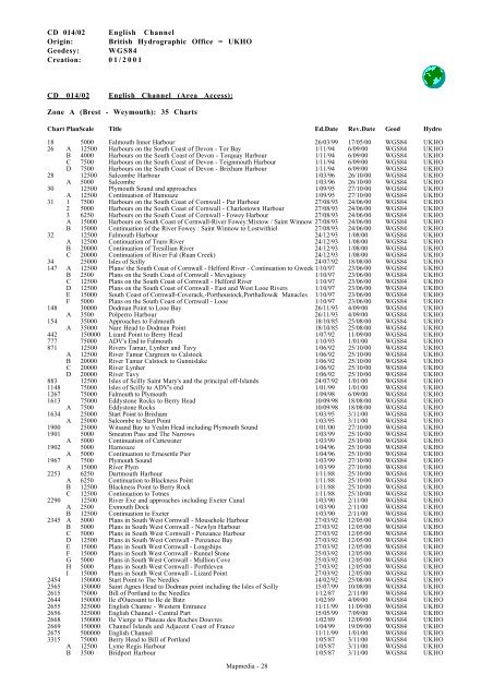
CD 014/02 English Channel (Area Access):<br />
Zone A (Brest - Weymouth): 35 Charts<br />
Chart PlanScale Title Ed.Date Rev.Date Geod Hydro<br />
18 5000 Falmouth Inner Harbour 26/03/99 17/05/00 WGS84 UKHO<br />
26 A 12500 Harbours on the South Coast of Devon - Tor Bay 1/11/94 6/09/00 WGS84 UKHO<br />
B 4000 Harbours on the South Coast of Devon - Torquay Harbour 1/11/94 6/09/00 WGS84 UKHO<br />
C 7500 Harbours on the South Coast of Devon - Teignmouth Harbour 1/11/94 6/09/00 WGS84 UKHO<br />
D 7500 Harbours on the South Coast of Devon - Brixham Harbour 1/11/94 6/09/00 WGS84 UKHO<br />
28 12500 Salcombe Harbour 1/03/96 26/10/00 WGS84 UKHO<br />
A 5000 Salcombe 1/03/96 26/10/00 WGS84 UKHO<br />
30 12500 Plymouth Sound and approaches 1/09/95 27/10/00 WGS84 UKHO<br />
A 12500 Continuation of Hamoaze 1/09/95 27/10/00 WGS84 UKHO<br />
31 1 7500 Harbours on the South Coast of Cornwall - Par Harbour 27/08/93 24/06/00 WGS84 UKHO<br />
2 5000 Harbours on the South Coast of Cornwall - Charlestown Harbour 27/08/93 24/06/00 WGS84 UKHO<br />
3 6250 Harbours on the South Coast of Cornwall - Fowey Harbour 27/08/93 24/06/00 WGS84 UKHO<br />
A 15000 Harbours on South Coast of Cornwall-River Fowey:Mixtow / Saint Winnow 27/08/93 24/06/00 WGS84 UKHO<br />
B 15000 Continuation of the River Fowey : Saint Winnow to Lostwithiel 27/08/93 24/06/00 WGS84 UKHO<br />
32 12500 Falmouth Harbour 24/12/93 1/08/00 WGS84 UKHO<br />
A 12500 Continuation of Truro River 24/12/93 1/08/00 WGS84 UKHO<br />
B 20000 Continuation of Tresillian River 24/12/93 1/08/00 WGS84 UKHO<br />
C 20000 Continuation of River Fal (Ruan Creek) 24/12/93 1/08/00 WGS84 UKHO<br />
34 25000 Isles of Scilly 24/07/92 18/08/00 WGS84 UKHO<br />
147 A 12500 Plans/ the South Coast of Cornwall - Helford River - Continuation to Gweek 1/10/97 23/06/00 WGS84 UKHO<br />
B 2500 Plans on the South Coast of Cornwall - Mevagissey 1/10/97 23/06/00 WGS84 UKHO<br />
C 12500 Plans on the South Coast of Cornwall - Helford River 1/10/97 23/06/00 WGS84 UKHO<br />
D 12500 Plans on the South Coast of Cornwall - East and West Looe Rivers 1/10/97 23/06/00 WGS84 UKHO<br />
E 15000 South Coast of Cornwall-Coverack,-Porthoustock,Porthallow& Manacles 1/10/97 23/06/00 WGS84 UKHO<br />
F 5000 Plans on the South Coast of Cornwall - Looe 1/10/97 23/06/00 WGS84 UKHO<br />
148 30000 Dodman Point to Looe Bay 26/11/93 4/09/00 WGS84 UKHO<br />
A 3500 Polperro Harbour 26/11/93 4/09/00 WGS84 UKHO<br />
154 35000 Approaches to Falmouth 18/10/85 25/08/00 WGS84 UKHO<br />
A 35000 Nare Head to Dodman Point 18/10/85 25/08/00 WGS84 UKHO<br />
442 150000 Lizard Point to Berry Head 1/07/92 11/09/00 WGS84 UKHO<br />
777 75000 ADV's End to Falmouth 1/10/93 1/01/00 WGS84 UKHO<br />
871 12500 Rivers Tamar, Lynher and Tavy 1/06/92 25/10/00 WGS84 UKHO<br />
A 12500 River Tamar Cargreen to Calstock 1/06/92 25/10/00 WGS84 UKHO<br />
B 20000 River Tamar Calstock to Gunnislake 1/06/92 25/10/00 WGS84 UKHO<br />
C 20000 River Lynher 1/06/92 25/10/00 WGS84 UKHO<br />
D 20000 River Tavy 1/06/92 25/10/00 WGS84 UKHO<br />
883 12500 Isles of Scilly Saint Mary's and the principal off-Islands 24/07/92 1/01/00 WGS84 UKHO<br />
1148 75000 Isles of Scilly to ADV's end 1/01/99 1/01/00 WGS84 UKHO<br />
1267 75000 Falmouth to Plymouth 1/09/98 6/09/00 WGS84 UKHO<br />
1613 75000 Eddystone Rocks to Berry Head 10/09/98 18/08/00 WGS84 UKHO<br />
A 7500 Eddystone Rocks 10/09/98 18/08/00 WGS84 UKHO<br />
1634 25000 Start Point to Brixham 1/03/95 3/11/00 WGS84 UKHO<br />
A 25000 Salcombe to Start Point 1/03/95 3/11/00 WGS84 UKHO<br />
1900 25000 Witsand Bay to Yealm Head including Plymouth Sound 1/01/00 27/10/00 WGS84 UKHO<br />
1901 5000 Smeaton Pass and The Narrows 1/03/99 25/10/00 WGS84 UKHO<br />
A 5000 Continuation of Cattewater 1/03/99 25/10/00 WGS84 UKHO<br />
1902 5000 Hamoaze 1/04/96 25/10/00 WGS84 UKHO<br />
A 5000 Continuation to Ernesettle Pier 1/04/96 25/10/00 WGS84 UKHO<br />
1967 7500 Plymouth Sound 1/03/99 27/10/00 WGS84 UKHO<br />
A 15000 River Plym 1/03/99 27/10/00 WGS84 UKHO<br />
2253 6250 Dartmouth Harbour 1/11/88 25/10/00 WGS84 UKHO<br />
A 6250 Continuation to Blackness Point 1/11/88 25/10/00 WGS84 UKHO<br />
B 12500 Blackness Point to Berry Rock 1/11/88 25/10/00 WGS84 UKHO<br />
C 12500 Continuation to Totnes 1/11/88 25/10/00 WGS84 UKHO<br />
2290 12500 River Exe and approaches including Exeter Canal 1/03/90 2/11/00 WGS84 UKHO<br />
A 2500 Exmouth Dock 1/03/90 2/11/00 WGS84 UKHO<br />
B 12500 Continuation to Exeter 1/03/90 2/11/00 WGS84 UKHO<br />
2345 A 5000 Plans in South West Cornwall - Mousehole Harbour 27/03/92 12/05/00 WGS84 UKHO<br />
B 5000 Plans in South West Cornwall - Newlyn Harbour 27/03/92 12/05/00 WGS84 UKHO<br />
C 5000 Plans in South West Cornwall - Penzance Harbour 27/03/92 12/05/00 WGS84 UKHO<br />
D 12500 Plans in South West Cornwall - Penzance Bay 27/03/92 12/05/00 WGS84 UKHO<br />
E 15000 Plans in South West Cornwall - Longships 27/03/92 12/05/00 WGS84 UKHO<br />
F 15000 Plans in South West Cornwall - Runnel Stone 25/03/92 12/05/00 WGS84 UKHO<br />
G 5000 Plans in South West Cornwall - Mullion Cove 25/03/92 12/05/00 WGS84 UKHO<br />
H 5000 Plans in South West Cornwall - Porthleven 27/03/92 12/05/00 WGS84 UKHO<br />
I 15000 Plans in South West Cornwall - Lizard Point 27/03/92 12/05/00 WGS84 UKHO<br />
2454 150000 Start Point to The Needles 14/02/92 25/08/00 WGS84 UKHO<br />
2565 150000 Saint Agnes Head to Dodman point including the Isles of Scilly 15/07/99 10/08/00 WGS84 UKHO<br />
2615 75000 Bill of Portland to the Needles 1/12/87 2/11/00 WGS84 UKHO<br />
2644 150000 Ile d'Ouessant to Ile de Batz 1/02/89 4/09/00 WGS84 UKHO<br />
2655 325000 English Channe - Western Entrance 11/11/99 11/09/00 WGS84 UKHO<br />
2656 325000 English Channel - Central Part 15/05/99 7/09/00 WGS84 UKHO<br />
2668 150000 Ile Vierge to Plateau des Roches Douvres 1/02/89 12/09/00 WGS84 UKHO<br />
2669 150000 Channel Islands and Adjacent Coast of France 1/04/99 19/09/00 WGS84 UKHO<br />
2675 500000 English Channel 11/11/99 1/01/00 WGS84 UKHO<br />
3315 75000 Berry Head to Bill of Portland 1/05/87 3/11/00 WGS84 UKHO<br />
A 12500 Lyme Regis Harbour 1/05/87 3/11/00 WGS84 UKHO<br />
B 3500 Bridport Harbour 1/05/87 3/11/00 WGS84 UKHO<br />
<strong>Mapmedia</strong> - 28


