
You also want an ePaper? Increase the reach of your titles
YUMPU automatically turns print PDFs into web optimized ePapers that Google loves.
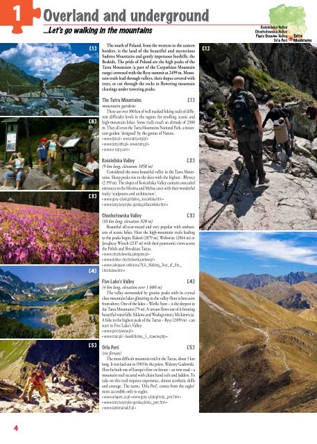
1 Overland and underground<br />
Overland and underground 9<br />
...Let’s go walking in the mountains<br />
[1]<br />
[6]<br />
[3]<br />
[4]<br />
[5]<br />
The south of <strong>Poland</strong>, from the western to the eastern<br />
borders, is the land of the beautiful and mysterious<br />
Sudetes Mountains and gently impetuous foothills, the<br />
Beskids. The pride of <strong>Poland</strong> are the high peaks of the<br />
Tatra Mountains (a part of the Carpathian Mountain<br />
range) crowned with the Rysy summit at 2499 m. Mountain<br />
trails lead through valleys, their slopes covered with<br />
trees, or cut through the rocks to flowering mountain<br />
clearings under towering peaks.<br />
The Tatra Mountains [1]<br />
mountain gardens<br />
There are over 300 km of well marked hiking trails of different<br />
difficulty levels in the region: for strolling, scenic and<br />
high-mountain hikes. Some trails reach an altitude of 2300<br />
m. They all cross the Tatra Mountains National Park, a mountain<br />
garden ‘designed’ by the genius of Nature.<br />
• www.tpn.pl • www.tatry.org/pl •<br />
• www.tatry.info.pl• www.tatry.pl •<br />
• www.e-tatry.com •<br />
Kościeliska Valley [2]<br />
(9 km long, elevation 1050 m)<br />
Considered the most beautiful valley in the Tatra Mountains.<br />
Sharp peaks rise to the skies with the highest - Błyszcz<br />
(2 159 m). The slopes of Kościeliska Valley contain concealed<br />
entrances to the Mroźna and Mylna caves with their wonderful<br />
rocky ‘sculptures and architecture’.<br />
• www.gory-szlaki.pl/dolina_koscieliska.htm •<br />
• www.tatry.turystyka-gorska.pl/koscieliska.htm •<br />
Chochołowska Valley [3]<br />
(10 km long, elevation 920 m)<br />
Beautiful all-year-round and very popular with enthusiasts<br />
of scenic hikes. Here the high-mountain trails leading<br />
to the peaks begin: Rakoń (1879 m), Wołowiec (2064 m) or<br />
Jarząbczy Wierch (2137 m) with their panoramic views across<br />
the Polish and Slovakian Tatras.<br />
• www.chocholowska.zakopane.pl •<br />
• www.dolina-chocholowska.witow.pl •<br />
• www.zakopane-online.eu/78,A_Walking_Tour_of_the_<br />
Chocholow.htm •<br />
Five Lake’s Valley [4]<br />
(4 km long, elevation over 1 600 m)<br />
The valley surrounded by granite peaks with its crystal<br />
clear mountain lakes glittering in the valley floor is best seen<br />
from above. One of the lakes – Wielki Staw – is the deepest in<br />
the Tatra Mountains (79 m). A stream flows out of it forming<br />
beautiful waterfalls: Siklawa and Wodogrzmoty Mickiewicza.<br />
A hike to the highest peak of the Tatras – Rysy (2499 m) - can<br />
start in Five Lake’s Valley.<br />
• www.piecstawow.pl •<br />
• www.man.pl/~lowell/dolina_5_stawow.php •<br />
Orla Perć [5]<br />
(vie ferrate)<br />
The most difficult mountain trail in the Tatras, about 5 km<br />
long. It was laid out in 1903 by the priest, Walenty Gadowski.<br />
Here he built one of Europe’s first vie ferrate – an iron road – a<br />
mountain trail secured with chain hand rails and ladders. To<br />
take on this trail requires experience, almost acrobatic skills<br />
and courage. The name, ‘Orla Perć’, comes from the eagles’<br />
nests accessible only to eagles.<br />
• www.orlaperc.za.pl • www.gory-szlaki.pl/orla_perc.htm •<br />
• www.tatry.turystyka-gorska.pl/orla_perc.htm •<br />
• www.tatromaniak.fr.pl •<br />
[1]<br />
Kościeliska Valley<br />
Chochołowska Valley<br />
Pięciu Stawów Valley<br />
Orla Perć<br />
Tatra<br />
Mountains<br />
European Walking<br />
Route E3<br />
E3<br />
Śnieżka<br />
The Śnieżnika<br />
Sudety<br />
E3massif<br />
E3<br />
Bieszczady<br />
E3<br />
4 5<br />
[1]<br />
...Let’s go walking in the mountains<br />
The Sudetes Mountains [6]<br />
beautiful and mysterious<br />
The Sudetes are covered by a net of picturesque trails.<br />
Some reach the highest cloudy peak of the Karkonosze range<br />
- Śnieżka (1 603 m), others thread through the Table Mountains.<br />
The Mountain Ghost, from Sudetian legends, can be<br />
encountered in the rocky labyrinths. When walking the trails<br />
in the Sudetes it is worth keeping an eye out for semi-precious<br />
stones which are abundant in these ancient mountains, or<br />
mufflons brought here from Corsica in the 19th century.<br />
The European Walking Route (E 3) crosses the Sudetes.<br />
It is several thousand kilometers long: from the coasts of the<br />
Atlantic to the Black Sea in the Ukraine. Other challenges are<br />
posed for hikers by the Orłowicz Main Sudetes Trail which,<br />
over a distance of 350 km, leads from Świeradów to Paczków<br />
through some of the most beautiful mountain scenery in the<br />
Sudetes Mountains, with intriguing, mysterious names: Raven<br />
Mountains, Owl, Table, Eagle and Golden.<br />
• www.panorama-miast.com.pl/41/html/bystrzyca.htm •<br />
• www.karkonosze.pl/sniezka/sniezka.php •<br />
• www.sudety.it/index/turystyka/szlaki/ID,7 •<br />
• www.sniezka.karpacz.pl • www.stolowe.yoyo.pl •<br />
• www.sudety.it/index/turystyka/szlaki/ID,1 •<br />
• www.sudety.it/index/gory/regiony/ID,10 •<br />
the mountain of the three seas [7]<br />
The Śnieżnika massif (1425 m) consists of several mountains.<br />
The flat crests with hewn out arduous slopes form viewing platforms<br />
from where you can marvel at this magical landscape.<br />
This region was discovered over 100 years ago by the Dutch<br />
princess, Marianne. Streams flowing into great European<br />
rivers: Oder, Elba and Danube and with them reaching the<br />
three seas, Baltic, Black and North Sea, have their sources here.<br />
• www.sudety.it/index/gory/regiony/ID,6 •<br />
Bieszczady [8]<br />
the mountains of burning beech trees<br />
The Bieszczady Mountains are difficult to pronounce for<br />
non-Polish speakers. But it is worth memorizing the name<br />
and visiting this region.<br />
This is a small region of <strong>Poland</strong> but with many attractions:<br />
bald peaks called połoniny, trails through the backwoods of<br />
the Carpathian Forest where traces of human activity merge<br />
with those of wolves and bears, then down to hospitable<br />
villages of wooden huts in the valleys with their Christian and<br />
Orthodox churches. Here at daybreak you can take a horse<br />
down a mountain trail, then at noon sail on the Solina Lake<br />
and in the afternoon you can walk to Caryńska Połonina and<br />
watch the sun set. In the evening you can listen to songs and<br />
poetry by a camp fire and have fresh trout for dinner. There<br />
are 120 km of marked trails and nature routes in the Bieszczady<br />
Mountains. The ‘border’ trail between <strong>Poland</strong>, Slovakia<br />
and Ukraine is very beautiful and it takes 30 hours to cover<br />
the 68 km. The lowest peak on the trail is Wysoki Groń (905<br />
m) and the highest Wielka Rawka (1304 m).<br />
• www.polandforall.com/bieszczady.html •<br />
• www.bieszczady.net.pl•<br />
Burning beech trees & blazing mountains [9]<br />
In the Bieszczady Mountains Nature’s show starts at<br />
the end of September. The beech trees growing on the<br />
mountain slopes are transformed into browns, reds and<br />
yellows and the mountains become a blaze of colours.<br />
The forest vistas are unforgettable; they quiver in the<br />
crystal clear air. Once seen you will drawn back over and<br />
over again.<br />
• www.twojebieszczady.pl •<br />
[6]<br />
[6]<br />
[6]<br />
[8]<br />
[9]