

Virtual Museums
Virtual Museums
Virtual Museums

Create successful ePaper yourself
Turn your PDF publications into a flip-book with our unique Google optimized e-Paper software.
<strong>Virtual</strong> Archaeology Review<br />
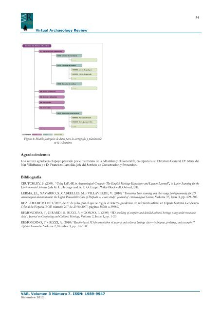
Figura 4: Modelo jerárquico de datos para la cartografía y planimetría<br />
en la Alhambra<br />
Agradecimientos<br />
Los autores agradecen el apoyo prestado por el Patronato de la Alhambra y el Generalife, en especial a su Directora General, Dª. María del<br />
Mar Villafranca y a D. Francisco Lamolda, Jefe del Servicio de Conservación y Protección.<br />
Bibliografía<br />
CRUTCHLEY, S. (2009). “Using LiDAR in Archaeological Contexts: The English Heritage Experience and Lessons Learned”, in Laser Scanning for the<br />
Environmental Sciences (eds G. L. Heritage and A. R. G. Large), Wiley-Blackwell, Oxford, UK.<br />
LERMA, J.L., NAVARRO, S., CABRELLES, M. y VILLAVERDE, V. (2010) “Terrestrial laser scanning and close range photogrammetry for 3D<br />
archaeological documentation: the Upper Palaeolithic Cave of Parpalló as a case study” Journal of Archaeological Science, Volume 37, Issue 3, pp. 499–507.<br />
REAL DECRETO 1071/2007, de 27 de julio, por el que se regula el sistema geodésico de referencia oficial en España Sistema Geodésico<br />
Oficial de España. BOE número 207 de 29/8/2007, páginas 35986 a 35989.<br />
REMONDINO, F., GIRARDI, S., RIZZI, A. y GONZO, L. (2009) “3D modeling of complex and detailed cultural heritage using multi-resolution<br />
data”, Journal on Computing and Cultural Heritage, Volume 2, Issue 1, pp. 1-20<br />
REMONDINO, F. y RIZZI, A. (2010) “Reality-based 3D documentation of natural and cultural heritage sites—techniques, problems, and examples.”<br />
Applied Geomatics Volume 2, Number 3, pp. 85-100<br />
VAR. Volumen 3 Número 7. ISSN: 1989-9947<br />
Diciembre 2012<br />
54