

Virtual Museums
Virtual Museums
Virtual Museums

You also want an ePaper? Increase the reach of your titles
YUMPU automatically turns print PDFs into web optimized ePapers that Google loves.
<strong>Virtual</strong> Archaeology Review<br />
2. The ancient potential landscape<br />
reconstruction<br />
a. Geology, soil-landscape and potentiality<br />
One of the priorities of the project was to find a convincing<br />
method to simulate the ecosystems and the soil use in the past,<br />
finalized to the reconstruction of the potential ancient landscape<br />
of the Tiber Valley in different ages. A fundamental contribution<br />
comes from geological and pedagogical studies.<br />
The area is composed mainly of sandy and conglomeratic<br />
sedimentary hills, which are partially covered by Middle-<br />
Pleistocene volcanic sediments, and to the east of calcareous<br />
mountain ranges reaching altitudes over 1200 m a.s.l. The Tiber<br />
valley occupies the depression separating the two volcanic<br />
edifices, Sabatino and Albano.<br />
The basis of the landscape study has been the existing semidetailed<br />
Soil-Landscape map, a theme showing the soil<br />
distribution in its context of lithology, morphology and<br />
watersheds. From this map, in combination with the known<br />
phytoclimatic spatial variation, the production potential for<br />
cereals (eventually with vine rows), olive/fruit trees and forests<br />
was derived. Several relative density scenarios of the various<br />
cultures were proposed.<br />
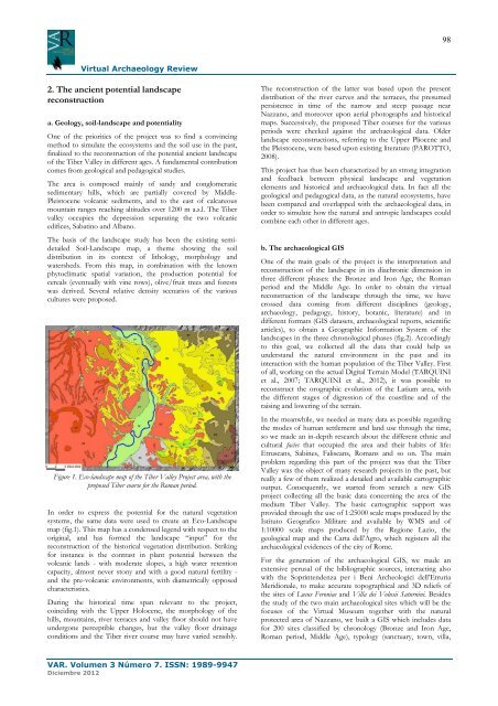
Figure 1. Eco-landscape map of the Tiber Valley Project area, with the<br />
proposed Tiber course for the Roman period.<br />
In order to express the potential for the natural vegetation<br />
systems, the same data were used to create an Eco-Landscape<br />
map (fig.1). This map has a condensed legend with respect to the<br />
original, and has formed the landscape “input” for the<br />
reconstruction of the historical vegetation distribution. Striking<br />
for instance is the contrast in plant potential between the<br />
volcanic lands - with moderate slopes, a high water retention<br />
capacity, almost never stony and with a good natural fertility -<br />
and the pre-volcanic environments, with diametrically opposed<br />
characteristics.<br />
During the historical time span relevant to the project,<br />
coinciding with the Upper Holocene, the morphology of the<br />
hills, mountains, river terraces and valley floor should not have<br />
undergone perceptible changes, but the valley floor drainage<br />
conditions and the Tiber river course may have varied sensibly.<br />
VAR. Volumen 3 Número 7. ISSN: 1989-9947<br />
Diciembre 2012<br />
The reconstruction of the latter was based upon the present<br />
distribution of the river curves and the terraces, the presumed<br />
persistence in time of the narrow and steep passage near<br />
Nazzano, and moreover upon aerial photographs and historical<br />
maps. Successively, the proposed Tiber courses for the various<br />
periods were checked against the archaeological data. Older<br />
landscape reconstructions, referring to the Upper Pliocene and<br />
the Pleistocene, were based upon existing literature (PAROTTO,<br />
2008).<br />
This project has thus been characterized by an strong integration<br />
and feedback between physical landscape and vegetation<br />
elements and historical and archaeological data. In fact all the<br />
geological and pedagogical data, as the natural ecosystems, have<br />
been compared and overlapped with the archaeological data, in<br />
order to simulate how the natural and antropic landscapes could<br />
combine each other in different ages.<br />
b. The archaeological GIS<br />
One of the main goals of the project is the interpretation and<br />
reconstruction of the landscape in its diachronic dimension in<br />
three different phases: the Bronze and Iron Age, the Roman<br />
period and the Middle Age. In order to obtain the virtual<br />
reconstruction of the landscape through the time, we have<br />
crossed data coming from different disciplines (geology,<br />
archaeology, pedagogy, history, botanic, literature) and in<br />
different formats (GIS datasets, archaeological reports, scientific<br />
articles), to obtain a Geographic Information System of the<br />
landscapes in the three chronological phases (fig.2). Accordingly<br />
to this goal, we collected all the data that could help us<br />
understand the natural environment in the past and its<br />
interaction with the human population of the Tiber Valley. First<br />
of all, working on the actual Digital Terrain Model (TARQUINI<br />
et al., 2007; TARQUINI et al., 2012), it was possible to<br />
reconstruct the orographic evolution of the Latium area, with<br />
the different stages of digression of the coastline and of the<br />
raising and lowering of the terrain.<br />
In the meanwhile, we needed as many data as possible regarding<br />
the modes of human settlement and land use through the time,<br />
so we made an in-depth research about the different ethnic and<br />
cultural facies that occupied the area and their habits of life:<br />
Etruscans, Sabines, Faliscans, Romans and so on. The main<br />
problem regarding this part of the project was that the Tiber<br />
Valley was the object of many research projects in the past, but<br />
really a few of them realized a detailed and available cartographic<br />
output. Consequently, we started from scratch a new GIS<br />
project collecting all the basic data concerning the area of the<br />
medium Tiber Valley. The basic cartographic support was<br />
provided through the use of 1:25000 scale maps produced by the<br />
Istituto Geografico Militare and available by WMS and of<br />
1:10000 scale maps produced by the Regione Lazio, the<br />
geological map and the Carta dell’Agro, which registers all the<br />
archaeological evidences of the city of Rome.<br />
For the generation of the archaeological GIS, we made an<br />
extensive perusal of the bibliographic sources, interacting also<br />
with the Soprintendenza per i Beni Archeologici dell’Etruria<br />
Meridionale, to make accurate topographical and 3D reliefs of<br />
the sites of Lucus Feroniae and Villa dei Volusii Saturnini. Besides<br />
the study of the two main archaeological sites which will be the<br />
focuses of the <strong>Virtual</strong> Museum together with the natural<br />
protected area of Nazzano, we built a GIS which includes data<br />
for 200 sites classified by chronology (Bronze and Iron Age,<br />
Roman period, Middle Age), typology (sanctuary, town, villa,<br />
98