GuÃa de la ecoruta Sumaco - Publicaciones - CAF
GuÃa de la ecoruta Sumaco - Publicaciones - CAF
GuÃa de la ecoruta Sumaco - Publicaciones - CAF

You also want an ePaper? Increase the reach of your titles
YUMPU automatically turns print PDFs into web optimized ePapers that Google loves.
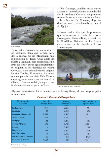
3. Río Cosanga, también recibe varios<br />
aportes en <strong>la</strong>s estribaciones orientales <strong>de</strong>l<br />
volcán Antisana. Corre en sus primeros<br />
tramos <strong>de</strong> oeste a este y antes <strong>de</strong> llegar<br />
a <strong>la</strong> pob<strong>la</strong>ción <strong>de</strong> Cosanga, fluye en<br />
dirección norte para <strong>de</strong>sembocar en el<br />
río Quijos.<br />
Río Cosanga.<br />
Entre estos drenajes se encuentra el<br />
río Cotundo, Tena que forman parte<br />
<strong>de</strong>l <strong>la</strong> cuenca <strong>de</strong>l río Misahualli, bajo<br />
<strong>la</strong> pob<strong>la</strong>ción <strong>de</strong> Tena. Aguas abajo <strong>de</strong>l<br />
puerto Misahualli, éste <strong>de</strong>semboca en el<br />
gran río Napo, cuyas aguas inicialmente<br />
se originan en los <strong>de</strong>shielos <strong>de</strong>l volcán<br />
Cotopaxi, (cara oriental) dando origen a<br />
los ríos Tambo, Tamboyacu, los cuales<br />
se unen para formar el río Valle Vicioso,<br />
cuyas aguas se unen a su vez con el río<br />
Chalupas formando el río Jatunyacu para<br />
finalmente formar el gran río Tena.<br />
Existen varios drenajes importantes<br />
que se observan a través <strong>de</strong> <strong>la</strong> ruta<br />
Cosanga-Archidona-Tena, a partir <strong>de</strong><br />
<strong>la</strong> Cordillera Oriental <strong>de</strong> los An<strong>de</strong>s<br />
en el sector <strong>de</strong> <strong>la</strong> Cordillera <strong>de</strong> los<br />
Guacamayos.<br />
Vapor <strong>de</strong> aguas termales Papayacta.<br />
Algunas características físicas <strong>de</strong> estas cuencas hidrográficas y <strong>de</strong> sus ríos principales<br />
se enumeran:<br />
Cuadro 1: Cuencas hidrográficas<br />
Nonmbre <strong>de</strong><br />
<strong>la</strong> cuenca<br />
Río Papal<strong>la</strong>cta<br />
Río Quijos<br />
Río Quijos AJ OYacachi<br />
Quijos en Baeza<br />
Río Quijos<br />
Cosanga AJ Quijos<br />
Cosanga<br />
Río Antisana<br />
Río Valle Vicioso<br />
Río Misahuallí en Cotundo<br />
Jatunyacu DJ Ilocullin<br />
Fuente: CGVG-USFQ.<br />
Area <strong>de</strong><br />
drenaje Km 2<br />
255<br />
122<br />
2.386<br />
840<br />
122<br />
495<br />
-<br />
263<br />
170<br />
141<br />
3.047<br />
Cota <strong>de</strong><br />
observación<br />
msnm<br />
2.200<br />
2.500<br />
1.490<br />
1.770<br />
3.400<br />
1.740<br />
3.400<br />
3.400<br />
3.300<br />
800<br />
570<br />
Caudal medio <strong>de</strong><br />
aporte m 3 /s<br />
10,81<br />
4,96<br />
198<br />
51,7<br />
4,95<br />
53,8<br />
1,88<br />
4,26<br />
6,97<br />
19,8<br />
361