GuÃa de la ecoruta Sumaco - Publicaciones - CAF
GuÃa de la ecoruta Sumaco - Publicaciones - CAF
GuÃa de la ecoruta Sumaco - Publicaciones - CAF

You also want an ePaper? Increase the reach of your titles
YUMPU automatically turns print PDFs into web optimized ePapers that Google loves.
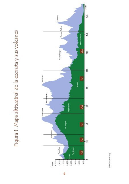
Figura 1: Mapa altitudinal <strong>de</strong> <strong>la</strong> <strong>ecoruta</strong> y sus volcanes<br />
Cotopaxi<br />
Antizana<br />
Sincho<strong>la</strong>gua<br />
msnm<br />
Rumiñahui<br />
4.000<br />
3.500 Pasochoa<br />
3.000<br />
2.500<br />
2.000<br />
1.500<br />
1.000<br />
500<br />
Quito<br />
Tumbaco<br />
<strong>Sumaco</strong><br />
Cerro Negro<br />
Pan <strong>de</strong> Azúcar<br />
La Virgen<br />
Papal<strong>la</strong>cta<br />
Baeza<br />
Pacto-<strong>Sumaco</strong><br />
0 20 40 60 80 100 120 140 160<br />
Fuente: CGVG-USFQ.<br />
Loreto