Create successful ePaper yourself
Turn your PDF publications into a flip-book with our unique Google optimized e-Paper software.
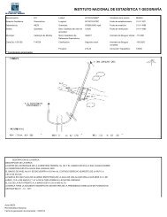
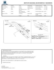
El proceso de la obtención de la fotografía aérea<br />
Fotografía Aérea Vuelo Fotográfico Lab. Fotográfico<br />
Esc. 1:75 K (revelado)<br />
Proyecto Esc. 1:37 K Control Fotogramétrico<br />
de Esc. 1:20 K (Actual control de vuelos)<br />
Vuelo Etc.<br />
(Zonas de trabajo Condiciones meteorológicas<br />
irregulares) cámara fotográfica, etc.)<br />
E - W - E<br />
SINFA Laboratorio Fotográfico