You also want an ePaper? Increase the reach of your titles
YUMPU automatically turns print PDFs into web optimized ePapers that Google loves.
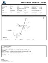
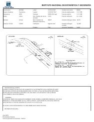
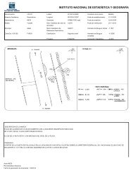
ORIGINALES DE LA <strong>CARTA</strong> <strong>TOPOGRÁFICA</strong><br />
LA <strong>CARTA</strong> <strong>TOPOGRÁFICA</strong>: Se elaboro de la restitución fotogramétrica de las fotografías aéreas, se obtuvieron 4<br />
originales, que unidos formaron un positivo sumado, del cual se obtuvo la prueba de color, necesaria para la edición estos<br />
originales son: CANEVA, ALTIMETRÍA, PLANIMETRIA, Y POSITIVO.<br />
CANEVA: Marco de la Carta-Marcas de las coordenadas geográficas - marcas de los valores UTM.<br />
ALTIMETRÍA: Curvas de nivel maestra, secundaria y auxiliar.<br />
PLANIMETRIA: Restituye las obras hechas por el hombre.<br />
POSITIVO: Copia en película fotográfica del original de Planimetria.<br />
PRUEBA DE COLOR: Material donde el clasificador de campo transfiere la información que recopila.