R E N A U D â G I Q U E L L O - Loeb Larocque
R E N A U D â G I Q U E L L O - Loeb Larocque
R E N A U D â G I Q U E L L O - Loeb Larocque

Create successful ePaper yourself
Turn your PDF publications into a flip-book with our unique Google optimized e-Paper software.
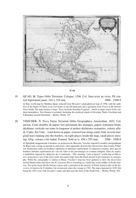
N o 18<br />
19 QUAD, M. Typus Orbis Terrarum. Cologne, 1596. Col. Sans texte au verso. Pli central<br />
légèrement jauni. 216 x 310 mm. 2000 - 2200 ¤<br />
wo Rare world map by Matthias Quad, reduced from Mercator’s planispherical map of 1596, with the addition<br />
of the figure of Christ in an oval frame in top left-hand part and a quotation from Cicero at the bottom.<br />
Verso blank. The map features a large “Terra Australis Nondum Cognitae”, which occupies much of the southern<br />
hemisphere. New Guinea is included. Including the mythical islands of Groclant, Thule, Frischlant and<br />
S.Brandam around Greenland. - Shirley, World, 197.<br />
20 VISSCHER, N. Nova Totius Terrarum Orbis Geographica. Amsterdam, 1652. Col.<br />
ancien. Carte doublée de papier fort présentant des manques, papier fortement bruni,<br />
déchirure verticale sur toute la longueur et petites déchirures restaurées, coloris affadi.<br />
Cadre. En l’état. - Laid down on paper, restored tear along center fold, several marginal<br />
tears running into the borders, on eight places inside the map, small pieces missing.<br />
Orig. colours a bit faded. Framed. Sold as is. 450 x 555 mm. 2500 - 3500 ¤<br />
wo Splendide mappemonde à bordures en projection de Mercator. Visscher reprend le modèle cartographique<br />
de Blaeu mais corrige et amende la carte pour y faire apparaître de nouvelles découvertes dans la baie d’Hudson.<br />
Richement ornée, les bordures supérieure et inférieure représentent 12 empereurs romains, alors que les<br />
bordures latérales représentent des vues de villes et des personnages en costume indigène. Dans les angles,<br />
4 médaillons figurent les allégories des 4 continents. - This stunning “carte-a-figures” world map on Mercator’s<br />
projection is one of the most richly decorated maps from the Dutch period of pre-eminence in cartography.<br />
While the cartography is similar to Blaeu, Visscher’s map has been updated to show the discoveries<br />
around Hudson Bay and shows the St. Lawrence River extending to a small lake in the middle of North America.<br />
Two polar insets fill the bottom corners and a cartouche in the interior of North America tells of the discovery<br />
of America by Columbus, but erroneously dates the voyage to 1592. The map originated in 1639, this<br />
being the 1652 issue with Visscher’s name and date near the inset of the South Pole. - Shirley, World, 350.<br />
8