R E N A U D â G I Q U E L L O - Loeb Larocque
R E N A U D â G I Q U E L L O - Loeb Larocque
R E N A U D â G I Q U E L L O - Loeb Larocque

Create successful ePaper yourself
Turn your PDF publications into a flip-book with our unique Google optimized e-Paper software.
POLOGNE - RUSSIE - SCANDINAVIE<br />
147 L’ISLE, G. de. / JEAN. La Pologne… / Royaume de Pologne. Paris, 1703-1806. Limites<br />
en col. ancien. Carte de Delisle coupée au filet d’encadrement, avec fente restaurée en<br />
bas du pli central, trous d’épingles aux angles. Les 2 cartes sont un peu jaunies. - Map<br />
by de L’Isle cut till neat line, repair of split lower part center fold. Pinholes in each<br />
corner. Both maps slightly age-toned. 479 x 625 mm. 150 - 250 ¤<br />
wo Lot of 2 maps of Poland. The map by de L’Isle, with the address : “Chez l’auteur sur le Quai de l’Horloge<br />
à l’Aigle d’Or” and dated 1703. The second map is an uncommon later issue after Sanson and published by<br />
Jean. The map has a deleted address in the cartouche, upper right.<br />
148 CHODZKO, L. Carte Générale Routière... De Pologne. Paris, 1840. Limites en col.<br />
ancien. Infimes rousseurs. 440 x 550 mm. 100 - 150 ¤<br />
Titre en polonais au-dessus de la carte. Avec 2 petits plans de Cracovie et Varsovie. Nombreux tableaux<br />
explicatifs relatifs à l’ancienne République de Pologne.<br />
149 ROBERT DE VAUGONDY, G. Carte Générale de l’Empire des Russes en Europe et<br />
en Asie. Paris, Delamarche, ca.1786. Limites en col. ancien. 2 taches d’encre sur la<br />
partie gauche. 470 x 1210 mm. 250 - 300 ¤<br />
wo Carte en 2 feuilles de l’empire russe. L’adresse diffère de celle donnée par Pedley : “A Paris chez le Sr.<br />
Delamarche Géog. Rue du Jardinet, N° 13, vis-à-vis celle de l’Eperon”. - This map of the Russian empire in<br />
2 sheets includes a detailed description of the river system, mountains and settlements in Siberia. The borders<br />
between the various governments are indicated with color. Lake Baikal is shown [drawn] in its correct<br />
location. Kamchatka, the Chukchi peninsula and Sakhalin island are represented. Their geographical shape<br />
is, like the northern coast of the Arctic Ocean and the island Nova Zembla, still imprecise. - Sponberg Pedley,<br />
Bel et utile, 73.2.<br />
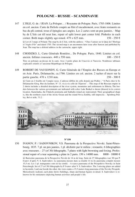
N o 150<br />
150 IVANOV, P. / SADOVNIKOV, V.S. Panorama de la Perspective Nevski. Saint-Pétersbourg,<br />
1835. 7 pl. un peu jaunies, 1 pl. déchirée par le milieu ; restaurée, 6 lithographies<br />
avec rousseurs. - 27 (of 30) lithographs. 7 plates with light browning and foxing. Professional<br />
repair of a tear separating a plate in 2 parts. 150 x 14000 mm. 8000 - 10000 ¤<br />
wo Rarissime panorama de la Perspective Nevski de 14 m de long. Suite de 27 lithographies (sur 30) par P.<br />
Ivanov d’après V. S. Sadovnikov. Le panorama mesure dans sa totalité 14 m (le panorama complet mesure<br />
15,5 m). Les 3 pl. manquantes sont en fac-similé. - A scarce panorama of the Prospektive Newsky in Saint<br />
Petersburgh. Set of 27 (of 30) lithographs by P. Ivanov after V. S. Sadovnikov. The 3 missing plates are added<br />
in facsimile. Laid one beside the other, the views make a 15,5 meters long panorama of the Nevsky Prospekt.<br />
Meticulously realized, each plate shows buildings, shops and human figures in detail. S. Sadovnikov is reknown<br />
for his miniatures depicting human activities and people’s life.<br />
37