R E N A U D â G I Q U E L L O - Loeb Larocque
R E N A U D â G I Q U E L L O - Loeb Larocque
R E N A U D â G I Q U E L L O - Loeb Larocque

You also want an ePaper? Increase the reach of your titles
YUMPU automatically turns print PDFs into web optimized ePapers that Google loves.
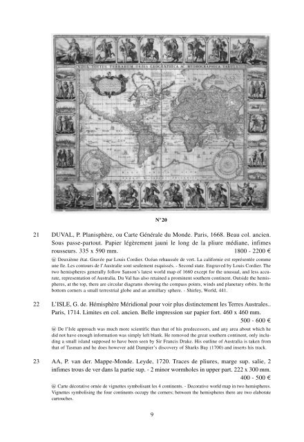
N o 20<br />
21 DUVAL, P. Planisphère, ou Carte Générale du Monde. Paris, 1668. Beau col. ancien.<br />
Sous passe-partout. Papier légèrement jauni le long de la pliure médiane, infimes<br />
rousseurs. 335 x 590 mm. 1800 - 2200 ¤<br />
wo Deuxième état. Gravée par Louis Cordier. Océan rehaussée de vert. La californie est représentée comme<br />
une île. Les contours de l’Australie sont seulement esquissés. - Second state. Engraved by Louis Cordier. The<br />
two hemispheres generally follow Sanson’s latest world map of 1660 except for the unusual, and less accurate,<br />
representation of Australia. Du Val has also retained a prominent southern continent. Outside the hemispheres,<br />
at the top, there are circular diagrams showing the compass points, winds and planetary orbits. In the<br />
bottom corners a small terrestrial globe and an armillary sphere. - Shirley, World, 441.<br />
22 L’ISLE, G. de. Hémisphère Méridional pour voir plus distinctement les Terres Australes..<br />
Paris, 1714. Limites en col. ancien. Belle impression sur papier fort. 460 x 460 mm.<br />
500 - 600 ¤<br />
wo De l’Isle approach was much more scientific than that of his predecessors, and any area about which he<br />
did not have enough information was simply left blank. He removed the great southern continent, only including<br />
a small island supposed to have been seen by Sir Francis Drake. His outline of Australia is taken from<br />
that of Tasman and he does however add Dampier’s discovery of Sharks Bay (1700) and inserts his track.<br />
23 AA, P. van der. Mappe-Monde. Leyde, 1720. Traces de pliures, marge sup. salie, 2<br />
infimes trous de ver dans la partie sup. - 2 minor wormholes in upper part. 222 x 300 mm.<br />
400 - 500 ¤<br />
wo Carte décorative ornée de vignettes symbolisant les 4 continents. - Decorative world map in two hemispheres.<br />
Vignettes symbolising the four continents occupy the corners; between the hemispheres there are two elaborate<br />
cartouches.<br />
9