R E N A U D â G I Q U E L L O - Loeb Larocque
R E N A U D â G I Q U E L L O - Loeb Larocque
R E N A U D â G I Q U E L L O - Loeb Larocque

You also want an ePaper? Increase the reach of your titles
YUMPU automatically turns print PDFs into web optimized ePapers that Google loves.
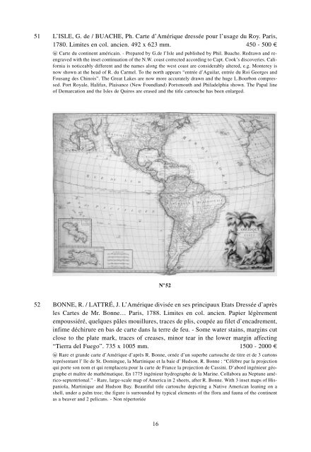
51 L’ISLE, G. de / BUACHE, Ph. Carte d’Amérique dressée pour l’usage du Roy. Paris,<br />
1780. Limites en col. ancien. 492 x 623 mm. 450 - 500 ¤<br />
wo Carte du continent américain. - Prepared by G.de l’Isle and published by Phil. Buache. Redrawn and reengraved<br />
with the inset continuation of the N.W. coast corrected according to Capt. Cook’s discoveries. California<br />
is noticeably different and the names along the west coast are considerably altered, e.g. Monterey is<br />
now shown at the head of R. du Carmel. To the north appears “entrée d’Aguilar, entrée du Roi Georges and<br />
Fousang des Chinois”. The Great Lakes are now more accurately drawn and the huge L.Bourbon compressed.<br />
Port Royale, Halifax, Plaisance (New Foundland) Portsmouth and Philadelphia shown. The Papal line<br />
of Demarcation and the Isles de Quiros are erased and the title cartouche has been enlarged.<br />
N o 52<br />
52 BONNE, R. / LATTRÉ, J. L’Amérique divisée en ses principaux Etats Dressée d’après<br />
les Cartes de Mr. Bonne… Paris, 1788. Limites en col. ancien. Papier légèrement<br />
empoussiéré, quelques pâles mouillures, traces de plis, coupée au filet d’encadrement,<br />
infime déchirure en bas de carte dans la terre de feu. - Some water stains, margins cut<br />
close to the plate mark, traces of creases, minor tear in the lower margin affecting<br />
“Tierra del Fuego”. 735 x 1005 mm. 1500 - 2000 ¤<br />
wo Rare et grande carte d’Amérique d’après R. Bonne, ornée d’un superbe cartouche de titre et de 3 cartons<br />
représentant l’ île de St. Domingue, la Martinique et la baie d’ Hudson. R. Bonne : “Célèbre par la projection<br />
qui porte son nom et qui remplacera pour la carte de France la projection de Cassini. D’abord ingénieur géographe<br />
et maître de mathématique. En 1775 ingénieur hydrographe de la Marine. Collabora au Neptune américo-septentrional.”<br />
- Rare, large-scale map of America in 2 sheets, after R. Bonne. With 3 inset maps of Hispaniola,<br />
Martinique and Hudson Bay. Beautiful title cartouche depicting a Native American leaning on a<br />
shell, under a palm tree; the figure is surrounded by typical elements of the flora and fauna of the continent<br />
as a beaver and 2 pelicans. - Non répertoriée<br />
16