R E N A U D â G I Q U E L L O - Loeb Larocque
R E N A U D â G I Q U E L L O - Loeb Larocque
R E N A U D â G I Q U E L L O - Loeb Larocque

You also want an ePaper? Increase the reach of your titles
YUMPU automatically turns print PDFs into web optimized ePapers that Google loves.
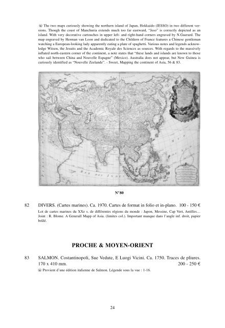
wo The two maps curiously showing the northern island of Japan, Hokkaido (IESSO) in two different versions.<br />
Though the coast of Manchuria extends much too far eastward, “Jeso” is correctly depicted as an<br />
island. With very decorative cartouches in upper left- and right-hand corners engraved by N.Guerard. The<br />
map engraved by Herman van Loon and dedicated to the Childern of France features a Chinese gentleman<br />
watching a European-looking lady apparently eating a plate of spaghetti. Various notes and legends acknowledge<br />
Witsen, the Jesuits and the Academic Royale des Sciences as sources. With regards to the massively<br />
inflated north-eastern corner of the continent, a note states that “these lands and islands are known to those<br />
who sail between China and Nouvelle Espagne” (Mexico). Australia does not appear, but New Guinea is<br />
curiously identified as “Nouvelle Zeelande”. - Sweet, Mapping the continent of Asia, 56 & 83.<br />
N o 80<br />
82 DIVERS. (Cartes marines). Ca. 1970. Cartes de format in folio et in-plano. 100 - 150 ¤<br />
Lot de cartes marines du XXe s. de différentes régions du monde : Japon, Messine, Cap Vert, Antilles…<br />
Joint : R. Blome. A Generall Mapp of Asia. (limites col.). Important manque dans l’angle inf. droit, papier<br />
brûlé.<br />
PROCHE & MOYEN-ORIENT<br />
83 SALMON. Costantinopoli, Sue Vedute, E Luogi Vicini. Ca. 1750. Traces de pliures.<br />
170 x 410 mm. 200 - 250 ¤<br />
wo Provient d’une édition italienne de Salmon. Légende sous la vue : 1-16.<br />
24