R E N A U D â G I Q U E L L O - Loeb Larocque
R E N A U D â G I Q U E L L O - Loeb Larocque
R E N A U D â G I Q U E L L O - Loeb Larocque

You also want an ePaper? Increase the reach of your titles
YUMPU automatically turns print PDFs into web optimized ePapers that Google loves.
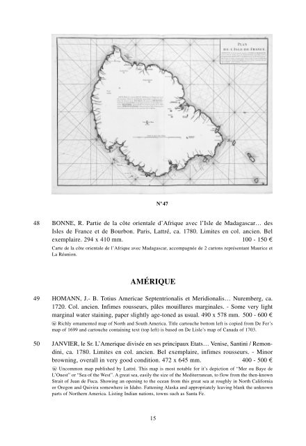
N o 47<br />
48 BONNE, R. Partie de la côte orientale d’Afrique avec l’Isle de Madagascar… des<br />
Isles de France et de Bourbon. Paris, Lattré, ca. 1780. Limites en col. ancien. Bel<br />
exemplaire. 294 x 410 mm. 100 - 150 ¤<br />
Carte de la côte orientale de l’Afrique avec Madagascar, accompagnée de 2 cartons représentant Maurice et<br />
La Réunion.<br />
AMÉRIQUE<br />
49 HOMANN, J.- B. Totius Americae Septentrionalis et Meridionalis… Nuremberg, ca.<br />
1720. Col. ancien. Infimes rousseurs, pâles mouillures marginales. - Some very light<br />
marginal water staining, paper slightly age-toned as usual. 490 x 578 mm. 500 - 600 ¤<br />
wo Richly ornamented map of North and South America. Title cartouche bottom left is copied from De Fer’s<br />
map of 1699 and cartouche containing text (top left) is based on De Lisle’s map of Canada of 1703.<br />
50 JANVIER, le Sr. L’Amerique divisée en ses principaux Etats… Venise, Santini / Remondini,<br />
ca. 1780. Limites en col. ancien. Bel exemplaire, infimes rousseurs. - Minor<br />
browning, overall in very good condition. 472 x 645 mm. 400 - 500 ¤<br />
wo Uncommon map published by Lattré. This map is most notable for it’s depiction of “Mer ou Baye de<br />
L’Ouest” or “Sea of the West”. A great sea, easily the size of the Mediterranean, to flow from the then-known<br />
Strait of Juan de Fuca. Showing an opening to the ocean from this great sea at roughly in North California<br />
or Oregon and Quivira somewhere in Idaho. Fattening Alaska and appropriately leaving blank the unknown<br />
parts of Northern America. Listing Indian nations, towns such as Santa Fe.<br />
15