
Create successful ePaper yourself
Turn your PDF publications into a flip-book with our unique Google optimized e-Paper software.
�<br />
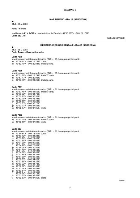
<strong>11</strong>.4 - 28-V-20<strong>08</strong><br />
Palau - Fanale<br />
SEZIONE B<br />
MAR TIRRENO - ITALIA (SARDEGNA)<br />
Modificare in Fl.Y.3s3M le caratteristiche del fanale in 41°10.890'N - 009°23.172'E.<br />
Carta 282 (33)<br />
MEDITERRANEO OCCIDENTALE - ITALIA (SARDEGNA)<br />
�<br />
<strong>11</strong>.5 - 28-V-20<strong>08</strong><br />
Porto Torres - Cavo sottomarino<br />
Carta 7379<br />
Inserire un cavo elettrico sottomarino (INT L - 31.1) congiungente i punti:<br />
a) 40°50.67'N - 0<strong>08</strong>°18.78'E, costa;<br />
b) 40°52.10'N - 0<strong>08</strong>°20.<strong>08</strong>'E, limite E carta.<br />
Carta 7380<br />
Inserire un cavo elettrico sottomarino (INT L - 31.1) congiungente i punti:<br />
a) 40°51.70'N - 0<strong>08</strong>°19.74'E, limite W carta;<br />
b) 40°53.17'N - 0<strong>08</strong>°20.96'E;<br />
c) 40°53.45'N - 0<strong>08</strong>°21.25'E, limite N carta.<br />
Carta 7381<br />
Inserire un cavo elettrico sottomarino (INT L - 31.1) congiungente i punti:<br />
a) 40°53.45'N - 0<strong>08</strong>°34.60'E, limite N carta;<br />
b) 40°53.32'N - 0<strong>08</strong>°34.70'E;<br />
c) 40°52.85'N - 0<strong>08</strong>°35.30'E;<br />
d) 40°52.79'N - 0<strong>08</strong>°35.38'E;<br />
e) 40°52.65'N - 0<strong>08</strong>°36.28'E;<br />
f) 40°52.65'N - 0<strong>08</strong>°36.72'E;<br />
g) 40°52.77'N - 0<strong>08</strong>°37.52'E;<br />
h) 40°52.87'N - 0<strong>08</strong>°37.95'E, costa.<br />
Carta 7382<br />
Inserire un cavo elettrico sottomarino (INT L - 31.1) congiungente i punti:<br />
a) 40°52.70'N - 0<strong>08</strong>°37.05'E, limite W carta;<br />
b) 40°52.85'N - 0<strong>08</strong>°37.93'E, costa.<br />
Carta 289<br />
Inserire un cavo elettrico sottomarino (INT L - 31.1) congiungente i punti:<br />
a) 40°50.64'N - 0<strong>08</strong>°18.80'E, costa;<br />
b) 40°53.42'N - 0<strong>08</strong>°21.28'E;<br />
c) 40°53.90'N - 0<strong>08</strong>°21.88'E;<br />
d) 40°53.98'N - 0<strong>08</strong>°22.02'E;<br />
e) 40°54.38'N - 0<strong>08</strong>°26.80'E;<br />
f) 40°54.28'N - 0<strong>08</strong>°29.85'E;<br />
g) 40°54.28'N - 0<strong>08</strong>°30.50'E;<br />
h) 40°54.18'N - 0<strong>08</strong>°31.52'E;<br />
i) 40°54.<strong>08</strong>'N - 0<strong>08</strong>°32.00'E;<br />
j) 40°53.98'N - 0<strong>08</strong>°33.22'E;<br />
k) 40°54.00'N - 0<strong>08</strong>°33.42'E;<br />
l) 40°53.95'N - 0<strong>08</strong>°34.<strong>08</strong>'E;<br />
m) 40°53.88'N - 0<strong>08</strong>°34.25'E;<br />
n) 40°53.32'N - 0<strong>08</strong>°34.78'E;<br />
o) 40°52.82'N - 0<strong>08</strong>°35.40'E;<br />
p) 40°52.78'N - 0<strong>08</strong>°35.48'E;<br />
q) 40°52.61'N - 0<strong>08</strong>°36.34'E;<br />
r) 40°52.64'N - 0<strong>08</strong>°36.79'E;<br />
s) 40°52.75'N - 0<strong>08</strong>°37.55'E;<br />
t) 40°52.83'N - 0<strong>08</strong>°37.95'E, costa.<br />
7<br />
(Scheda 637/20<strong>08</strong>)<br />
segue