


Create successful ePaper yourself
Turn your PDF publications into a flip-book with our unique Google optimized e-Paper software.
CAPO D’ORSO<br />
… presenta una somiglianza<br />
singolare già da circa duemila anni,<br />
perché Tolomeo nella sua Geografia<br />
indica questo luogo con il nome<br />
di Arktoy Akra (promontorio dell’orso),<br />
ciò mostra quanto tempo è stato<br />
necessario per prendere la massa<br />
del granito questa forma…<br />
ALBERTO DELLA MARMORA,<br />
da Itinerario dell’Isola<br />
di Sardegna,1860
PALAU<br />
Il nome di <strong>Palau</strong> deriva dal catalanospagnolo<br />
parar “fermarsi”, “ripararsi” e<br />
dai derivati paratge, paraje, che significano<br />
“tratto di mare in prossimità della<br />
costa” e anche “riparo per navi e imbarcazioni”.<br />
Nelle prime carte catastali piemontesi<br />
è riportato come Parau o Parao,<br />
quindi riparato. Un nome di buon auspicio<br />
per chi vuole andare per mare e il mare a<br />
<strong>Palau</strong> è di casa. Dal 2005, <strong>Palau</strong> è Comune<br />
d’Europa, gemellato con Saint Genest-<br />
Lerpt, cittadina francese del Dipartimento<br />
della Loira, nel parco naturale del Pilat. Qui<br />
vive una comunità italiana, perfettamente<br />
integrata nel contesto locale, che ricorda il<br />
non lontano passato minerario del piccolo<br />
centro.<br />
Una vocazione internazionale<br />
LO STEMMA<br />
Lo stemma del comune di <strong>Palau</strong> contiene<br />
una duplice simbologia. L’orso ricorda che<br />
il suo territorio, da epoche antichissime, è<br />
identificato con l’omonima roccia che<br />
sovrasta il mare. Lo stemma è dominato<br />
però dalla figura di San Giorgio che uccide<br />
il drago: è una rappresentazione della fede<br />
che sconfigge il male e si richiama alla<br />
chiesa campestre che sorge nella campagna<br />
nei pressi del fiume Liscia. Sull’altro lato<br />
del fiume sorge la chiesa campestre di<br />
S.Michele e ai due santi era affidato il compito<br />
di proteggere il territorio da chi risalendo<br />
il fiume poteva minacciare coloro<br />
che popolavano la piana: un chiaro<br />
rimando alle incursioni dei Saraceni,<br />
che fino a metà dell’Ottocento minacciarono<br />
le coste sarde. Anche la croce<br />
rossa in campo bianco è lo stemma di<br />
San Giorgio, ma in più è il simbolo<br />
della Repubblica Pisana che ebbe<br />
grande influenza sulle coste sarde<br />
intorno al XII-XIII secolo.<br />
THE COAT OF ARMS<br />
The coat of arms of the municipality<br />
of <strong>Palau</strong> symbolizes two distinct<br />
emblems. The bear illustrates how<br />
the area has been identified since ancient times<br />
by the bear shaped rock overlooking the sea.<br />
However, the coat of arms is monopolised by the<br />
figure of Saint George slaying the dragon: this<br />
is a representation of how faith can overcome<br />
evil and is reminiscent of the country church<br />
located in the vicinity of the Liscia River. The<br />
opposite bank of the river houses the country<br />
church of S. Michele and the two saints were<br />
entrusted with the task of protecting the area<br />
from those who, on coming up river, were in a<br />
position to threaten the population living in the<br />
plain: a clear reference to the Saracen invasions<br />
which endangered the coasts of Sardinia up<br />
until the Mid Nineteenth century. The red<br />
cross on a white background depicting St.<br />
George’s coat of arms is also evocative of the<br />
Pisan Republic which exerted a considerable<br />
influence on the Sardinian coasts between the<br />
XII-XIII centuries.
AN INTERNATIONAL VOCATION<br />
The name <strong>Palau</strong> derives from the<br />
Catalan-Spanish term parar meaning<br />
“to stop”, “to shelter” and from<br />
the derivatives paratge, paraje, meaning<br />
“stretch of sea near the coast” or “haven for<br />
ships and sea craft”. In the first maps drawn<br />
up by the Piedmontese the town is indicated as<br />
Parau or Parao, therefore sheltered. A providential<br />
name for those wishing to sail the seas<br />
and indeed in <strong>Palau</strong> the sea is paramount. In<br />
2005 <strong>Palau</strong> became a European Municipality<br />
twinned with Saint Genest-Lerpt, a French<br />
town situated in the Department of the Loire<br />
in the Pilat natural park area. A fully integrated<br />
Italian community resides there reminiscent<br />
of the mining activities carried out in<br />
this small town up until fairly recent times.<br />
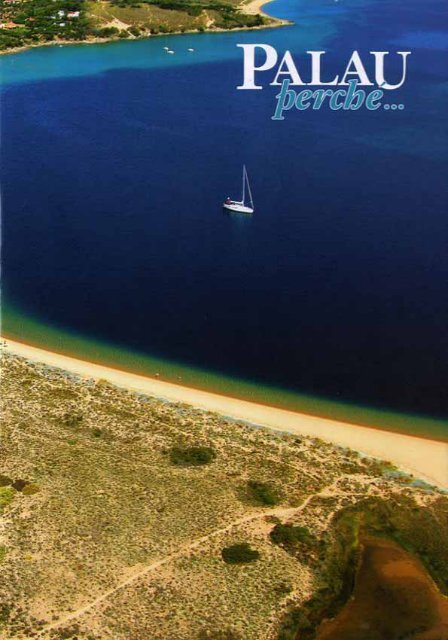
In alto, nella pagina<br />
a fianco, una veduta<br />
panoramica di<br />
<strong>Palau</strong>; a sinistra,<br />
la rada di Mezzo<br />
Schifo; sopra la<br />
chiesetta di<br />
San Giorgio<br />
UNE VOCATION INTERNATIONALE<br />
Le nom de <strong>Palau</strong> vient du catalan-espagnol parar “s’arrêter”,<br />
“se protéger” et de ses dérivés paratge, paraje qui signifient<br />
“portion de mer en proximité de la côte” et aussi “abri pour les<br />
navires et les embarcations”. Dans les premiers documents cadastraux piémontais,<br />
le nom indiqué est Parau ou bien Parao, qui signifie “protégé”.<br />
Un nom placé sous de bons auspices pour ceux qui souhaitent naviguer en<br />
mer. A <strong>Palau</strong>, la mer fait partie intégrante de la vie. Depuis 2005, <strong>Palau</strong><br />
est une Commune d’Europe jumelée avec Saint Genest-Lerpt, petite ville<br />
française du Département de la Loire (dans le parc naturel du Pilat).<br />
Dans cette petite ville, vit une communauté italienne parfaitement intégrée<br />
au contexte local qui rappelle son passé minier assez récent.<br />
LES ARMES<br />
Les armes de la Ville de <strong>Palau</strong> renferment un double symbole. L’ours rappelle<br />
que le territoire de <strong>Palau</strong> est identifié depuis une époque très ancienne<br />
à la Roche de l’Ours qui surplombe la mer. Les armes sont dominées par la<br />
figure de Saint Georges qui tue le dragon : il s’agit d’une représentation de<br />
la foi qui vainc le mal et se rapporte à l’église de campagne qui se trouve<br />
aux environs du fleuve Liscia. Sur l’autre rive du fleuve, se trouve l’église<br />
de campagne de Saint Michel ; à ces deux saints était confié la charge de<br />
protéger le territoire de ceux qui, en remontant le fleuve, pouvait menacer<br />
les peuples de la plaine : une nette référence aux incursions des sarrasins,<br />
qui jusqu’à la moitié du XIX ème siècle menacèrent les côtes de la Sardaigne.<br />
La croix rouge sur fond blanc est l’arme de Saint Gorges, mais elle est également<br />
le symbole de la République de Pise qui eut une influence importante<br />
sur les côtes de la Sardaigne aux XII ème et XIII ème siècles.<br />
VON INTERNATIONALEM RUF<br />
Der Name von <strong>Palau</strong> stammt von dem katalanischen Wort parar<br />
“anhalten”, “Schutz suchen” und den Begriffen paratge, paraje,<br />
also “Meeresabschnitt in Küstennähe” oder auch “Unterschlupf für<br />
Schiffe und Boote”, ab. In den ersten piemontesischen Katasterkarten<br />
erscheint der Name Parau oder Parao, was soviel bedeutet wie<br />
„geschützt“. Ein Name mit guten Vorzeichen also für diejenigen, die ans<br />
Meer fahren möchten, denn das Meer ist in <strong>Palau</strong> zuhause. Seit 2005 ist<br />
<strong>Palau</strong> Europagemeinde, Städtepartner von Saint Genest-Lerpt, einem französischen<br />
Städtchen des Loiredepartements im Naturpark Pilat. Dort lebt<br />
eine italienische Gemeinschaft, die perfekt in das lokale Umfeld integriert ist,<br />
welches an die nicht allzu ferne Bergbauvergangenheit des kleinen Zentrums<br />
erinnert.<br />
DAS WAPPEN<br />
Das Wappen der Gemeinde <strong>Palau</strong> enthält eine doppelte Symbolik. Der Bär erinnert<br />
daran, dass das Gebiet von alters her mit dem gleichnamigen Felsen, der sich<br />
über dem Meer erhebt, identifiziert wird. Dominiert wird das Wappen jedoch von<br />
der Gestalt des Heiligen Giorgio, der den Drachen tötet: Es handelt sich um eine<br />
Darstellung des Glaubens, der das Böse besiegt und bezieht sich auf die kleine Kirche<br />
auf dem Land, in der Nähe des Flusses Liscia. Auf der anderen Seite des Flusses<br />
befindet sich die Landkirche des heiligen Michele (San Michele); den beiden<br />
Heiligen war die Aufgabe anvertraut, das Gebiet vor denjenigen, die flussaufwärts<br />
kamen und die in der Ebene lebende Bevölkerung bedrohen konnten zu<br />
schützen. Ein klarer Verweis auf die Überfälle der Sarazenen, die bis zur Hälfte<br />
des 19. Jahrhunderts die sardischen Küsten bedrohten. Auch das rote Kreuz auf<br />
weißem Grund ist das Wappen des Heiligen Giorgio, aber darüber hinaus auch<br />
das Symbol der Republik Pisa, die in der Zeit um das 13. und 14. Jahrhundert<br />
großen Einfluss auf die sardischen Küsten hatte.
CALA DI TRANA<br />
… Poco oltre <strong>Palau</strong> ecco un angolo di costa<br />
ancora miracolosamente intatto: la Cala di<br />
Trana … chiusa su tre lati dalle maestose<br />
sculture granitiche che caratterizzano<br />
Punta Sardegna…<br />
FULCO PRATESI, da Guida alla Natura<br />
della Sardegna, 1973
LA STORIA<br />
La formazione del nucleo urbano di<br />
<strong>Palau</strong> ha un simbolo, di proprietà dell’Amministrazione<br />
Comunale: è il<br />
Palazzo Fresi, adibito a Biblioteca Comunale,<br />
Punto di Informazione Turistica e sede della<br />
Consulta degli Anziani. Costruito nel 1875,<br />
più volte ampliato e ristrutturato, fu la prima<br />
costruzione dove oggi sorge la città e fu il<br />
centro di attrazione attorno al quale crebbe<br />
<strong>Palau</strong>. Ma la storia dell’insediamento nel territorio<br />
di <strong>Palau</strong> si basa su due capisaldi<br />
antecedenti. Da una parte la straordinaria<br />
continuità tra gli insediamenti antichi, a partire<br />
dall’epoca prenuragica, e quelli moderni,<br />
settecenteschi e ottocenteschi, distribuiti in<br />
modo diffuso nell’entroterra, in quella che<br />
viene oggi chiamata la civiltà degli stazzi.<br />
Dall’altra la proiezione marinara del territorio<br />
legata principalmente allo sviluppo militare<br />
e strategico delle isole dell’Arcipelago di<br />
La Maddalena e alla necessità di collegamenti<br />
stabili con l’isola maggiore. Tra la fine del<br />
Settecento e l’inizio dell’Ottocento sono le<br />
vicende militari a segnare la storia: la cacciata<br />
di Napoleone dall’Isola di Santo Stefano nel<br />
HISTORY<br />
The foundation of the urban centre<br />
of <strong>Palau</strong> is perpetuated with a symbol,<br />
Palazzo Fresi, property of the<br />
Municipal Administrative Authorities and<br />
today in use as a Town Library, Tourist Information<br />
Point and headquarters of the Council<br />
of Elders. Built in 1875 and subsequently<br />
extended and renovated, it was the first<br />
building constructed in the modern town as<br />
we know it today and constituted a centre of<br />
attraction around which <strong>Palau</strong> flourished.<br />
However, the history of the establishing of<br />
<strong>Palau</strong> is based on two previous strongholds.<br />
On one side the remarkable continuity existing<br />
between the settlements of old, dating as<br />
far back as the pre-Nuragic era, and the<br />
modern Eighteenth and Nineteenth century<br />
dwellings which were widely distributed<br />
throughout the hinterland according to the socalled<br />
‘stazzi’ (rural) civilisation. On the<br />
other the seafaring disposition of the territory,<br />
linked in particular to the military and<br />
strategic development of the islands comprising<br />
the Archipelago of La Maddalena and the<br />
need to establish steady connections with the<br />
main island. Between the end of the Eighteenth<br />
century and the start of the Nineteenth<br />
century military issues set the historical pace:<br />
the expulsion of Napoleon from the island of<br />
Santo Stefano in 1793, the presence of Admiral<br />
Nelson’s fleet from 1803 to 1805 offshore<br />
in the Mezzo Schifo roadstead and, from<br />
1887 onwards the reinforcing of the defence<br />
system with the Batteries on Mount Altura<br />
and at Capo d’Orso, together with a series of<br />
other military constructions. It should be<br />
borne to mind that up until the mid Nineteenth<br />
century coastal settlements in the Gallura<br />
region were few and far between due to<br />
the pressure of barbaric invasions along the<br />
coast and to the diffusion of malaria in coastal<br />
areas. The construction of the first road from<br />
Sassari to Tempio Pausania took place in<br />
1880 and a tarmac surface was applied only<br />
in 1908, whilst the railway came to <strong>Palau</strong> in<br />
1932. <strong>Palau</strong> became an autonomous municipality<br />
in 1959: this elicited a steady increase<br />
in development of the area and its economy,<br />
witnessing also the start of a marked propensity<br />
for tourism. The modern day <strong>Palau</strong> has<br />
made hospitality its trademark.
1793, la permanenza della flotta dell’ammiraglio<br />
Nelson tra il 1803 ed il 1805 nella Rada<br />
di Mezzo Schifo e a partire dal 1887 il rafforzamento<br />
del sistema difensivo con le Batterie<br />
di Monte Altura e di Capo d’Orso e una<br />
serie di altre strutture militari. Non va<br />
dimenticato che fino alla metà dell’Ottocento<br />
gli insediamenti costieri in Gallura erano<br />
quasi inesistenti, in conseguenza della pressione<br />
sulle coste delle incursioni barbaresche<br />
e per la diffusione della malaria nelle lagune<br />
costiere. Il collegamento stradale con Sassari<br />
e Tempio Pausania è datato 1880 e la strada fu<br />
asfaltata nel 1908, mentre la ferrovia giunse a<br />
<strong>Palau</strong> nel 1932. <strong>Palau</strong> diviene comune<br />
autonomo nel 1959: inizia allora, con progressiva<br />
accelerazione, lo sviluppo urbano ed<br />
economico e l’assunzione della spiccata<br />
propensione turistica. Oggi <strong>Palau</strong> fa dell’ospitalità<br />
la propria bandiera.<br />
Nella pagina a fianco, L’Ammiraglio Nelson,<br />
e, sotto: Palazzo Fresi. In questa pagina, la<br />
fortezza di Monte Altura<br />
Cent’anni di accoglienza<br />
L’HISTOIRE<br />
La formation du noyau urbain de <strong>Palau</strong> a un<br />
symbole qui est aujourd’hui propriété de l’Administration<br />
municipale. Il s’agit du Palais Fresi,<br />
transformé en Bibliothèque municipale, Point<br />
d’Information Touristique et siège du Conseil des Anciens.<br />
Il fut construit en 1875, agrandit et restructuré à plusieurs<br />
reprises et ce fut la première construction de la ville<br />
et le centre autour duquel s’est construite la Ville de <strong>Palau</strong>.<br />
Mais l’histoire de l’implantation sur le territoire de la<br />
Ville de <strong>Palau</strong> se base sur deux antécédents importants.<br />
D’une part, l’extraordinaire continuité entre les implantations<br />
antiques (à partir de l’époque pré nuragique) et les<br />
implantations modernes (aux XVIII éme et XIX ème<br />
siècles) réparties de façon diffuse dans l’arrière-pays, pendant<br />
la période appelée aujourd’hui la “civiltà degli stazzi”<br />
(civilisation agraire). D’autre part, la projection<br />
marinière du territoire liée principalement au développement<br />
militaire et stratégique des îles de l’Archipel de La<br />
Maddalena et aux nécessités de liaisons stables avec l’île<br />
majeure. Entre la fin du XVIII ème siècle et le début du<br />
XIX ème siècle, les évènements militaires marquent l’histoire<br />
: l’expulsion de Napoléon de l’île de Santo Stefano en<br />
1793, le séjour de la flotte de l’Amiral Nelson entre 1803<br />
et 1805 dans la Rade de Mezzo Schifo et, à partir de<br />
1887, le renforcement du système de défense avec les batteries<br />
du Mont Altura et de Capo d’Orso ainsi qu’une série<br />
d’autres structures militaires. Il ne faut pas oublier que<br />
jusqu’à la moitié du XIX ème siècle, les implantations<br />
côtières en Gallura était presque totalement inexistantes<br />
suite à la pression sur les côtes des incursions barbares et à<br />
la diffusion de la malaria dans les lagunes côtières. La liaison<br />
routière avec Sassari et Tempio Pausania date de 1880<br />
et la route fut asphaltée en 1908 tandis que le chemin de<br />
fer parvint jusqu’à <strong>Palau</strong> en 1932. <strong>Palau</strong> devint municipalité<br />
autonome en 1959 : commença alors, avec une accélération<br />
progressive, le développement urbain et économique<br />
et un net penchant pour le tourisme. Aujourd’hui,<br />
<strong>Palau</strong> a fait de l’hospitalité son mot d’ordre.<br />
DIE GESCHICHTE<br />
Für die Bildung des Stadtkerns von <strong>Palau</strong> steht ein<br />
Symbol, das sich heute im Besitz der Kommunalverwaltung<br />
befindet: Der Palazzo Fresi, der als<br />
Stadtbibliothek, Touristeninformation und Sitz des Seniorenrats<br />
dient. Erbaut im Jahre 1875, mehrmals erweitert und<br />
restauriert, war der Palazzo das erste Bauwerk dort, wo sich<br />
heute die Stadt befindet und daher der Mittelpunkt, um welchen<br />
sich <strong>Palau</strong> bildete. Aber die Geschichte der Besiedlung im<br />
Gebiet von <strong>Palau</strong> beruht auf zwei weiteren, weiter zurückliegenden<br />
Tatsachen: Einerseits die außergewöhnliche Kontinuität<br />
zwischen den antiken Siedlungen seit der prae-nuragischen<br />
Epoche und den modernen aus dem 18. und 19. Jahrhundert,<br />
welche verstreut im Landesinneren verteilt sind und<br />
heute als Kultur der „stazzi“ (Höfe“) bezeichnet werden,<br />
andererseits die Seefahrerkultur des Gebiets, die vor allem an<br />
die militärische und strategische Entwicklung der Inseln im<br />
Maddalena-Archipel und das Bedürfnis nach beständigen Verbindungen<br />
mit der größten Insel gebunden war. Zwischen<br />
Ende des 18. und Anfang des 19. Jahrhunderts sind es die<br />
militärischen Ereignisse, welche die Geschichte beeinflussen:<br />
Die Vertreibung Napoleons von der Insel Santo Stefano 1793,<br />
der Aufenthalt von Admiral Nelsons Flotte zwischen 1803<br />
und 1805 in der Reede von Mezzo Schifo und seit 1887 die<br />
Verstärkung des Verteidigungssystems mit den Festungen von<br />
Monte Altura und Capo d’Orso, auch Bärenkap genannt,<br />
sowie einer Reihe weiterer militärischer Strukturen. Dabei ist<br />
zu beachten, dass bis zur Hälfte des 19. Jahrhunderts praktisch<br />
keine Küstensiedlungen in Gallurien existierten, eine Folge des<br />
Drucks, der von den Barbaren durch Überfälle auf die Küsten<br />
ausgeübt wurde sowie der Ausbreitung von Malaria in den<br />
Küstenlagunen. Die Verbindungsstraße mit Sassari und Tempio<br />
Pausania wird 1880 erbaut und 1908 asphaltiert,<br />
während die Eisenbahnlinie <strong>Palau</strong> im Jahre 1932 erreicht.<br />
1959 wird <strong>Palau</strong> eine autonome Kommune, und mit diesem<br />
Moment beginnt zunächst schrittweise, dann zunehmend<br />
schneller der urbane und wirtschaftliche Fortschritt sowie das<br />
deutlich ausgeprägte Interesse am Tourismus. Heutzutage hat<br />
die Gastfreundschaft in <strong>Palau</strong> einen hohen Stellenwert.
IL FARO<br />
“...Dalla rada di Mezzo Schiffo, per andare al<br />
piccolo porto della Maddalena, vi sono miglia<br />
2, e la direzione è ben facile. Si osservano, in<br />
mezzo a questa gran rada due gruppi di scogli,<br />
uno di 7 e l’altro di 3, e tanto il primo quanto<br />
il secondo gruppo si possono avvicinare a mezza<br />
gomena di distanza tutt’intorno...”<br />
CONTRO-AMMIRAGLIO ALBINI,<br />
da Guida del Piloto nel littorale dell’Isola di<br />
Sardegna, 1845
IL TERRITORIO<br />
Vento, acqua, mare, sabbia e granito<br />
dipingono gli scenari della costa di<br />
<strong>Palau</strong>: dalle dune della foce del Liscia<br />
a occidente fino al Golfo delle Saline<br />
paesaggi di grande suggestione si rincorrono.<br />
Non ci sono solo la roccia dell’Orso o<br />
la spiaggia dell’Isuledda (oggi Isola dei Gabbiani)<br />
a fare da attrazioni, ma un’infinità di<br />
angoli incantevoli, spesso nascosti e dove il<br />
variare delle stagioni regala spettacoli inattesi.<br />
Come la fioritura delle rose di mare a<br />
maggio sulle dune di Cala di Trana e dell’Isuledda,<br />
come il gioco di rocce e sabbia a<br />
Porto Cuncato. Come il confine incerto tra<br />
mare e terra nella parte più interna di Porto<br />
Puddu o come l’imponente scenario dei<br />
blocchi di granito di Punta Sardegna. E di<br />
fronte si apre il panorama delle isole dell’Arcipelago<br />
di La Maddalena a fare da filtro<br />
alle correnti che solcano impetuose le Bocche<br />
di Bonifacio. Anche l’interno si rivela<br />
sorprendente con il gioco dei rilievi di granito<br />
sul tessuto di macchia e campi coltivati.<br />
Percorrere gli sterrati dell’entroterra a<br />
passo d’uomo, non a ritmo di rally, consente<br />
di assaporare l’anima antica della Gallura,<br />
dove spazio e tempo si dilatano e diventano<br />
testimoni di un modo di un vivere antico.<br />
THE CHARM OF THE LOCALITY<br />
Wind, water, sea, sand and granite<br />
illustrate the scenery along the coasts of<br />
<strong>Palau</strong>: panoramas of remarkable<br />
beauty stretch from the dunes at the mouth of the<br />
river Liscia to the west and as far as the Golfo<br />
delle Saline. The Bear rock or the beach of Isuledda<br />
are not the only attractions, but rather a myriad<br />
of enchanting spots, at times totally secluded,<br />
where the changing seasons afford unexpected<br />
pageants. Such as the blooming of the sea roses in<br />
May along the dunes of Cala di Trana and<br />
Isuledda, or the frolic of rocks and sand in Porto<br />
Cuncato. Or the enigmatic border between sea<br />
and land in the innermost part of Porto Puddu or<br />
again the imposing view of the granite blocks at<br />
Punta Sardegna. The panorama overlooking the<br />
islands of the Archipelago of La Maddalena opens<br />
out in front of you, obstructing the currents that<br />
blow impetuously through the Strait of Bonifacio.<br />
Likewise, the hinterland proves to be a revelation<br />
interspersing the granite mountains with<br />
Mediterranean shrubs and cultivated fields. To<br />
walk along the trails of the hinterland at a<br />
leisurely pace, not at the speed of a rally, allows<br />
one to savour the ancient spirit of the Gallura<br />
region where space and time expand to bear witness<br />
to the age old way of life.<br />
PORTO RAFAEL<br />
To live is to dream. Porto Rafael was founded on<br />
this concept expressed by Rafael Neville, Count of<br />
Berlanga, at the beginning of the 1960’s. A<br />
Spaniard, lover of the sea, the Count hoped to<br />
accomplish his dream along the coast leading up to<br />
Punta Sardegna, approximately 4 km from the<br />
centre of <strong>Palau</strong>. Nowadays, following the demise<br />
of the Count and his entourage of artists, this<br />
small tourist complex is well integrated into the<br />
landscape surrounding the square, constituting an<br />
excellent example of how tourist town planning<br />
can effectively be achieved without spoiling the<br />
essence of the location. A small well-equipped<br />
tourist harbour faces directly onto the sea.
PORTO RAFAEL<br />
Sognare è vivere. Nasce da questa idea<br />
Porto Rafael, dall’intuizione di Rafael<br />
Neville, Conte di Berlanga, nei primi anni<br />
’60 del secolo scorso. Spagnolo, amante<br />
del mare, il conte volle trovare nel tratto<br />
di costa che porta a Punta Sardegna, a<br />
circa 4 km dal centro di <strong>Palau</strong>, la realizzazione<br />
dei suoi sogni. Oggi il piccolo<br />
insediamento turistico, scomparso il conte<br />
e il suo seguito di artisti, continua a vivere<br />
nel paesaggio, attorno alla piazzetta, ottimo<br />
esempio di come si può fare urbanizzazione<br />
turistica senza rubare lo spirito dei luoghi.<br />
Nelle vicinanze, il porticciolo, ben attrezzato<br />
pur nelle piccole dimensioni.<br />
La magia del Luogo<br />
Nell’altra pagina, il fiume Liscia, sopra, la<br />
piazzetta di Porto Rafael e, in alto a destra,<br />
Rafael Neville, conte di Berlanga<br />
LA MAGIE DU LIEU<br />
Le vent, l’eau, la mer, le sable et le granit campent le décor de<br />
la côte de <strong>Palau</strong> : des dunes de l’embouchure du fleuve Liscia à<br />
l’ouest jusqu’au Golfe des Salines, l’on rencontre des paysages<br />
très suggestifs. Il n’y a pas uniquement la Roche de l’Ours et la plage de<br />
l’Isuledda comme attrait, mais une infinité de lieux enchanteurs, souvent<br />
cachés et où le changement des saisons offre des spectacles inattendus.<br />
Des spectacles tels que la floraison des anémones de mer au mois de mai<br />
sur les dunes de Cala di Trana et de l’Isuledda ; le jeu des roches et du<br />
sable à Porto Cuncato ; la frontière incertaine entre mer et terre dans<br />
la partie plus intérieure de Porto Puddu ou bien l’imposant décor des<br />
blocs de granit de Punta Sardegna. Face à ces lieux se présente le panorama<br />
des îles de l’Archipel de La Maddalena qui filtrent les courants qui<br />
sillonnent de façon impétueuse les Bouches de Bonifacio. L’arrière-pays se<br />
révèle également surprenant avec le jeu des reliefs de granit sur le tissu<br />
de maquis et de champs cultivés. Parcourir les chemins de terre de l’arrière-pays<br />
au pas, et non pas à un rythme de rallye, permet d’apprécier<br />
la véritable âme de la Gallura, où espace et temps se dilatent et deviennent<br />
témoins d’un mode de vie antique.<br />
PORTO RAFAEL<br />
Rêver veut dire vivre. Porto Rafael naît de cette idée, de l’intuition de<br />
Rafael Neville, Conte de Berlanga, au début des années 60 du siècle dernier.<br />
Espagnol, amant de la mer, le conte a voulut réaliser ses rêves dans<br />
la portion de côte qui va jusqu’à Punta Sardegna, à environ 4 Km du<br />
centre de <strong>Palau</strong>. Aujourd’hui, le conte et sa suite d’artistes ayant disparus,<br />
la petite implantation touristique est insérée dans le paysage, autour<br />
d’une petite place, parfait exemple de réalisation d’une urbanisation touristique<br />
qui préserve l’esprit des lieux. En bord de mer, le port de plaisance<br />
est bien équipé, même s’il reste de dimensions modestes.<br />
MAGIE<br />
Wind, Wasser, Meer, Sand und Granit prägen die Szenerien der Küste<br />
von <strong>Palau</strong>; von den Dünen an der Flussmündung der Liscia im Westen<br />
bis zum Golf der Salinen wechseln sich beeindruckende Landschaften ab.<br />
Zu den Attraktionen zählen nicht nur der Roccia dell’Orso (Bärenfelsen) oder der<br />
Strand von Isuledda, sondern eine unendliche Anzahl von zauberhaften, oftmals verstecken<br />
Orten, wo der Wechsel der Jahreszeiten dem Betrachter unerwartete Naturschauspiele<br />
schenkt. So zum Beispiel die Blüte der Zistrosen im Mai auf den Dünen<br />
der Cala di Trana und Isuledda, das Spiel von Felsen und Sand in Porto Cuncato, der<br />
unbestimmbare Übergang zwischen Meer und Festland in dem etwas weiter innerhalb<br />
gelegenen Teil von Porto Puddu oder das imposante Szenarium der Granitblöcke<br />
in Punta Sardegna. Gegenüber öffnet sich das Panorama der Inseln des Maddalena-<br />
Archipels, das die Strömungen drosselt, die ungestüm die Straße von Bonifacio zerfurchen.<br />
Auch das Landesinnere entpuppt sich als überraschend schön mit seinen Granitreliefs,<br />
die sich in der „Macchia“, dem typisch mediterranen Buschwald, und den<br />
bestellten Feldern erheben. Ein Gang über die Wege im Landesinneren, langsamen<br />
Schrittes, ohne in die gewohnte Hektik zu verfallen, erlaubt dem Besucher, in die antike<br />
Seele Galluriens einzutauchen, wo Zeit und Raum sich ausdehnen und zu Zeugen<br />
einer antiken Lebensweise werden.<br />
PORTO RAFAEL<br />
Träumen heißt Leben. Aus dieser Idee entsteht Porto Rafael, dank einer Intuition von<br />
Rafael Neville, Graf von Berlanga, Anfang der 60er Jahre des vorigen Jahrhunderts.<br />
Neville, Spanier, mit einer Passion für das Meer, wollte im Küstenabschnitt, der nach<br />
Punta Sardegna führt, circa 4 km von <strong>Palau</strong> entfernt, seine Träume realisieren.<br />
Heute ist der kleine touristische Ort, nach dem Verschwinden des Grafen und seines<br />
künstlerischen Gefolges, um den kleinen Hauptplatz herum gelegen und in die Landschaft<br />
eingefügt, ein optimales Beispiel dafür, wie man touristische Urbanisierung<br />
durchführen kann, ohne einen Ort seiner Ausstrahlung zu berauben. Direkt am Meer<br />
befindet sich der kleine aber dennoch gut ausgestattete Hafen.
LA SCIUMARA
… Sulle sue piccole spiagge, d’estate, si<br />
riversano moltissimi bagnanti, venuti<br />
da ogni parte della Gallura. Molti sono<br />
anche i turisti…<br />
ANTONIO MURINEDDU, da Gallura, 1962
LA COSTA<br />
Dimmi di che spiaggia sei<br />
Lungo i 25 chilometri di costa del territorio<br />
di <strong>Palau</strong> sono 21 le spiagge<br />
piccole e grandi che si offrono al visitatore,<br />
ciascuna con caratteristiche<br />
diverse. La maggior parte sono facilmente<br />
raggiungibili. Chi vuole invece la spiaggia<br />
esclusiva deve impegnarsi un po’ per conquistarla,<br />
ma ne vale sempre la pena. Nel<br />
Golfo delle Saline ci sono ben 4 spiagge:<br />
quella delle Saline, quella degli Svedesi,<br />
Vena Longa (Porto Mannu) e Cala Capra.<br />
Nei pressi della cittadina, le spiagge di<br />
Punta Nera e dell’Isolotto sono facilmente<br />
raggiungibili, come sull’altro versante<br />
quelle di <strong>Palau</strong> Vecchio e Porto Faro.<br />
Seguendo il litorale si trova poi la spiaggia<br />
di La Galatea, mentre la spiaggia di <strong>Palau</strong><br />
per antonomasia è quella della Sciumara al<br />
fondo della rada di Mezzo Schifo: questo<br />
TELL ME HOW YOUR BEACH<br />
SHOULD BE<br />
Along the 25 kilometres of coast<br />
present throughout the <strong>Palau</strong> territory,<br />
23 beaches ranging from large to small<br />
are at the visitor’s disposal, each completely different<br />
from the next. Some are better suited for<br />
those who wish to have access to all types of<br />
commodity without having to lift a finger. On<br />
the contrary, those seeking an exclusive beach<br />
will have to toil a little to reach it, although it<br />
will have been well worth the trouble. The<br />
“Golfo delle Saline” comprises 3 different<br />
beaches: Vena Longa (Porto Mannu), the beach<br />
of the Capo d’Orso camp site and Cala Capra.<br />
Nearer to the town the beaches of Punta Nera<br />
and Isolotto are within easy reach, as are those<br />
of <strong>Palau</strong> Vecchio and Porto Faro on the other<br />
side. Proceeding along the coast you come to the<br />
beach of La Galatea, whilst the beach conventionally<br />
thought of as the beach of <strong>Palau</strong> is that<br />
of Sciumara situated at the end of the Mezzo<br />
Schifo roadstead. The term “Mezzo Schifo”<br />
(repugnance) was not used to convey the meaning<br />
of disgust, but rather recalls an ancient<br />
type of sea craft used in assisting the large ships<br />
and can likely be dated back to the presence in<br />
the roadstead during the Nineteenth century of<br />
the English fleet led by Admiral Nelson. The<br />
same applies to the bay of Cala Inglese (English
Cove) adjacent to Porto Rafael, with its square<br />
overlooking the beach of the same name. La<br />
Sciumara can be reached either from the centre<br />
of <strong>Palau</strong> or from the road that leads to<br />
Porto Rafael. The tiny beach of Cala Martinella<br />
can be reached from the road leading to<br />
the lighthouse at Punta Sardegna. Those wishing<br />
to succeed in gaining access to their own<br />
magnificent beach may visit the white sandy<br />
beach of Cala di Trana with its backdrop of<br />
dunes only partly colonised by indigenous<br />
plants. It can be reached by sea or along a footpath,<br />
after having crossed an unmade up area<br />
leading from the road running from <strong>Palau</strong> to<br />
Costa Serena. Access to the beaches of Porto<br />
Cuncato and Talmone must also be deserved,<br />
firstly by means of a walk starting from the<br />
rotunda at Costa Serena. At the end of Porto<br />
Puddu, in the deep creek snaking towards<br />
Costa Serena another breathtaking beach is to<br />
be found in a stretch of coast where the currents<br />
are continually modifying the relationship<br />
between the sea and the land. Slightly further<br />
east is the long beach of the Dunes of Porto<br />
Puddu and Porto Liscia with the marshland of<br />
Padula Piatta in the background. Even further<br />
on, through the district of Porto Puddu,<br />
you will come to the beach at the isthmus which<br />
links Isuledda to the mainland (also known as<br />
the Isola dei Gabbiani / Isle of Gulls). This<br />
stretch of coast is hewn by the wind, the currents<br />
and by the motion of the river Liscia<br />
marking the boundary of <strong>Palau</strong> to the west and<br />
backing onto the dunes of Sciumara del Liscia,<br />
a natural area of inestimable appeal where<br />
surfers from all over the world gather to take<br />
advantage of the wind.<br />
nome non ha nulla a che vedere con il<br />
ribrezzo, ma ricorda un antico tipo di<br />
imbarcazione di servizio per le grandi navi e<br />
probabilmente è da collegare con la presenza<br />
ottocentesca della flotta inglese dell’Ammiraglio<br />
Nelson proprio in questa rada, così<br />
come Cala Inglese nei pressi di Porto<br />
Rafael, che a sua volta ha la piazzetta affacciata<br />
sulla spiaggia omonima. La Sciumara<br />
si raggiunge dal centro di <strong>Palau</strong>. La piccolissima<br />
spiaggia di Cala Martinella si raggiunge<br />
invece dalla strada che conduce al<br />
faro di Punta Sardegna. Per chi la spiaggia<br />
bellissima vuole conquistarsela c’è Cala di<br />
Trana, di sabbia candida, con alle spalle un<br />
complesso dunale, solo in parte colonizzato<br />
da piante pioniere. La si raggiunge via mare<br />
oppure a piedi attraverso un sentiero, dopo<br />
aver percorso uno sterrato che si imbocca<br />
dalla strada che da <strong>Palau</strong> porta a Costa Serena.<br />
Anche le spiagge di Porto Cuncato e<br />
Talmone vanno conquistate con una camminata<br />
che inizia dalla rotonda raggiungibile<br />
da Costa Serena. Al fondo di Porto<br />
Puddu, nella profonda insenatura che si<br />
addentra verso Costa Serena c’è un’altra<br />
bellissima spiaggia, in un tratto dove le correnti<br />
trasformano continuamente il rapporto<br />
mare e terra.<br />
A sinistra: Costa<br />
Serena, sopra,<br />
Porto Cuncato
Per gli appassionati<br />
del vento, <strong>Palau</strong><br />
è un paradiso<br />
Poco più ad est c’è la lunga spiaggia delle<br />
Dune di Porto Puddu e di Porto Liscia, con<br />
alle spalle la zona umida di Padula Piatta.<br />
Più in là ancora, raggiungibile da Porto<br />
Puddu, c’è la spiaggia dell’istmo che congiunge<br />
alla terraferma l’Isuledda (nota<br />
anche come Isola dei Gabbiani).<br />
Questo tratto di costa è plasmato dal vento,<br />
dalle correnti e dagli apporti del fiume Liscia<br />
che segna il confine di <strong>Palau</strong> ad occidente e<br />
che sta alle spalle del complesso dunale della<br />
Sciumara del Liscia, un angolo di natura dal<br />
fascino inestimabile, dove si radunano a cercare<br />
il vento surfisti di tutto il mondo.<br />
DIS-MOI DE QUELLE PLAGE TU ES<br />
Le long des 25 kilomètres de côte du territoire de <strong>Palau</strong>, 23<br />
plages petites et grandes s’offrent au visiteur, chacune ayant<br />
des caractéristiques différentes des autres. Certaines sont équipées<br />
pour ceux qui veulent toutes les commodités sans bouger le petit<br />
doigt. Ceux qui désirent, au contraire, une plage exclusive, doivent se<br />
bouger pour y accéder, mais cela en vaut toujours la peine. Dans le Golfe<br />
des Salines, il y a 3 plages : celle de Vena Longa (Porto Mannu), celle du<br />
camping Capo d’Orso et celle de Cala Capra. Près de la ville, les plages<br />
de Punta Nera et de l’Isolotto sont faciles d’accès, ainsi que sur l’autre<br />
versant, les plages de <strong>Palau</strong> Vecchio et Porto Faro. En suivant le littoral,<br />
l’on trouve la plage de La Galatea, tandis que la plage en titre de <strong>Palau</strong><br />
est celle de la Sciumara au fond de la rade de Mezzo Schifo : ce nom n’a<br />
rien a voir avec le dégoût, mais il rappelle un ancien type d’embarcation<br />
de service pour les grands navires et il est probablement lié à la présence<br />
durant le XIX ème siècle de la flotte anglaise de l’Amiral Nelson dans<br />
cette rade, tout comme à Cala Inglese dans les environs de Porto Rafael<br />
dont la petite place se trouve face à la plage du même nom. La Sciumara<br />
est accessible par le centre de <strong>Palau</strong> ou bien par la route qui conduit à<br />
Porto Rafael. La petite plage de Cala Martinella est accessible par la<br />
route qui conduit au phare de Punta Sardegna.<br />
Pour ceux qui veulent conquérir une très belle<br />
plage, il y a Cala di Trana, une plage de sable<br />
immaculé, adossée à un ensemble de dunes en<br />
partie colonisé par des plantes pionnières. Cette<br />
plage est accessible par la mer ou bien à pied en<br />
suivant un sentier, après avoir parcouru un<br />
chemin de terre depuis la route qui va de <strong>Palau</strong><br />
à Costa Serena. Les plages de Porto Cuncato et<br />
de Talmone également ne sont accessibles<br />
qu’après une promenade qui part de la rotonde<br />
accessible depuis Costa Serena. Au fond de<br />
Porto Puddu, dans la profonde crique qui va<br />
jusqu’à Costa Serena, se trouve une autre<br />
plage magnifique, à un endroit où les courants<br />
transforment continuellement le rapport mer<br />
et terre. Un peu plus à l’est, se trouve la longue<br />
plage des Dunes de Porto Puddu et de Porto<br />
Liscia, adossé à la zone humide de Padula<br />
Piatta. Au-delà, accessible par le hameau de<br />
Porto Puddu, se trouve la plage de l’isthme qui<br />
relie l’Isuledda (connue aussi sous le nom d’Ile<br />
des Goélands) à la terre ferme. Cette portion<br />
de côte est façonnée par le vent, par les courants<br />
et par les apports du fleuve Liscia qui marque<br />
la frontière de <strong>Palau</strong> à l’ouest et qui est adossé<br />
à l’ensemble des dunes de la Sciumara du fleuve<br />
Liscia, une portion de nature à l’attrait<br />
inestimable où se retrouve des surfeurs du<br />
monde entier à la recherche du vent idéal.<br />
STRÄNDE ÜBER STRÄNDE<br />
Entlang der 25 km langen Küste von<br />
<strong>Palau</strong> gibt es 23 kleine und große<br />
Strände, von denen sich ein jeder dem<br />
Besucher mit verschiedenen Charakteristiken<br />
präsentiert. Einige Strände bieten jeglichen<br />
Komfort für diejenigen, die keinen Finger<br />
rühren wollen. Wer einen exklusiven Strand<br />
bevorzugt, muss sich allerdings etwas anstrengen,<br />
um ihn zu erreichen, aber das ist die Sache<br />
in jedem Fall wert. Im Golf der Salinen gibt es<br />
gleich drei Strände: Vena Longa (Porto<br />
Mannu), der Strand des Campingplatzes Capo<br />
d’Orso und der von Cala Capra. In der Nähe<br />
der Stadt sind die Strände Punta Nera und Isolotto<br />
einfach zu erreichen und auf der anderen<br />
Seite die Strände von <strong>Palau</strong> Vecchio und Porto<br />
Faro. Entlang der Küste trifft man dann auf<br />
den Strand La Galatea, während der Strand<br />
von <strong>Palau</strong> schlechthin der Sciumara-Strand<br />
am Ende der Reede von Mezzo Schifo ist. Der<br />
Name der Reede hat nichts mit Abscheu (Anm.<br />
d. Ü.: ital. “schifo“ = Ekel) zu tun, sondern<br />
erinnert an eine alte Art von Hilfsbooten zu<br />
Diensten großer Schiffe und ist wahrscheinlich<br />
auf die Anwesenheit der Flotte Admiral Nelsons<br />
im 19. Jahrhundert in eben dieser Bucht<br />
zurückzuführen, wie auch Cala Inglese in der<br />
Nähe von Porto Rafael, deren kleiner Hauptplatz<br />
auf einen gleichnamigen Strand blickt. La<br />
Sciumara kann man sowohl vom Zentrum <strong>Palau</strong>s<br />
aus als auch von der Straße, die nach Porto<br />
Rafael führt, erreichen. Den winzigen Strand<br />
Cala Martinella hingegen erreicht man von der<br />
Straße aus, die zum Leuchtturm von Punta<br />
Sardegna führt. Wer sich seinen Traumstrand<br />
erobern will, sollte Cala di Trana mit seinem<br />
weißem Sand und dem Dünenkomplex, nur<br />
teilweise von Pionierpflanzen bewachsen, besuchen.<br />
Zu erreichen ist dieser Strand über das<br />
Meer, oder zu Fuß über einen Pfad, der von<br />
dem unbefestigten Weg abgeht, den man auf<br />
der Straße von <strong>Palau</strong> nach Costa Serena ein-
Il Trenino Verde<br />
schlagen muss. Auch die Strände von Porto<br />
Cuncato und Talmone müssen durch eine Wanderung<br />
mit Beginn an dem Rondell, das man<br />
von Costa Serena aus erreicht, erobert werden.<br />
Am Ende von Porto Puddu, in der tiefen Bucht,<br />
die sich Richtung Costa Serena noch vertieft,<br />
gibt es einen weiteren wunderschönen Strand<br />
an einer Stelle, wo die Strömungen die Grenze<br />
zwischen Meer und Festland ständig verändern.<br />
Etwas weiter im Osten liegt der lange<br />
Dünenstrand von Porto Puddu und Porto Liscia.<br />
Dahinter das Feuchtgebiet von Padula<br />
Piatta. Noch ein Stück weiter, zu erreichen von<br />
Porto Puddu, liegt der Strand der Landenge,<br />
welche Isuledda (auch als Isola dei Gabbiani<br />
oder Möweninsel bekannt) mit dem Festland<br />
verbindet. Dieser Küstenabschnitt ist vom<br />
Wind, den Strömungen und den Zuflüssen der<br />
Liscia geformt. Letztere bildet die Grenze <strong>Palau</strong>s<br />
im Westen und befindet sich hinter dem<br />
Dünenkomplex der Sciumara der Liscia, ein<br />
faszinierender von der Natur geschaffener Ort,<br />
wo sich Surfer aus der ganzen Welt auf der<br />
Suche nach Wind versammeln.<br />
Di solito si prende il treno per andare da un<br />
posto all’altro: non è così se si sale sul Trenino<br />
Verde che da <strong>Palau</strong> va a Tempio Pausania<br />
e più in là fino a Nulvi. Perché in questo caso<br />
si va per il gusto di viaggiare sulle vecchie carrozze<br />
delle linee a scartamento ridotto delle<br />
Ferrovie della Sardegna e per avere l’opportunità<br />
di attraversare zone della Gallura interna<br />
non raggiungibili con altri mezzi. Si possono<br />
così scoprire angoli di rara suggestione,<br />
tra boschi di sughere, rilievi di granito,<br />
costeggiando le rive del lago del Liscia. Si<br />
giunge infine a Tempio, alle pendici del<br />
Monte Limbara. Di qui si può proseguire per<br />
l’altra tratta e si attraversano i territori di<br />
comuni come Aggius, circondato da guglie di<br />
granito, e Bortigiadas con i rilievi coperti<br />
dalla macchia e dalle querce. Poi lo sbuffante<br />
trenino, prima di giungere a Nulvi, attraversa<br />
il territorio di Perfugas e Laerru, da dove<br />
vengono le prime tracce della presenza<br />
umana in Sardegna e l’aura di questa storia<br />
arcana scorre con il lento procedere del<br />
treno. Un’esperienza da non perdere.<br />
Il treno si ferma<br />
alla pineta di <strong>Palau</strong><br />
Vecchio per far<br />
scendere i bagnanti.<br />
Sotto, un tipico<br />
paesaggio gallurese,<br />
godibile dal treno<br />
TRENINO VERDE (The Tourist Train)<br />
Trains are usually taken to travel<br />
from one place to another: this is not<br />
the case when stepping onto the<br />
Trenino Verde which goes from <strong>Palau</strong> to Tempio<br />
Pausania and even as far as Nulvi. You<br />
take this train for the pleasure of travelling on<br />
the antique carriages of the narrow-gauge<br />
tracks of the Sardinian Railways and for the<br />
opportunity of crossing zones of the “Gallura”<br />
hinterland which cannot be reached by other<br />
means. In this way you can explore the exceptional<br />
beauty of the surroundings, cork woods,<br />
granite mountains, gliding past the banks of<br />
the artificial lake built on the Liscia River. At<br />
last we reach Tempio, at the foot of Mount<br />
Limbara. From here you can opt to continue<br />
along the second route, crossing the territories<br />
of municipalities such as Aggius, surrounded by<br />
granite spires, and Bortigiadas with its peaks<br />
covered in Mediterranean shrubs and oak<br />
trees. Before reaching Nulvi, the puffing train<br />
crosses the lands of Perfugas and Laerru where<br />
the first traces of human presence in Sardinia<br />
were first discovered and where the breath of<br />
this mystical tale fades slowly as the train haltingly<br />
proceeds. An experience not to be missed.<br />
TRENINO VERDE (Le petit train vert)<br />
D’habitude, l’on prend le train pour<br />
se déplacer d’un point à un autre.<br />
Cela n’est pas le cas en ce qui concerne<br />
le Petit Train Vert qui va de <strong>Palau</strong> à Tempio<br />
Pausania et, ensuite, jusqu’à Nulvi. L’on<br />
prend ce train pour le plaisir de voyager dans<br />
les vieux wagons des lignes à voie étroite des<br />
Chemins de fer de la Sardaigne et pour avoir<br />
l’opportunité de traverser des zones de la Gallura<br />
intérieure que l’on ne peut pas atteindre<br />
avec d’autres moyens de transport. L’on peut<br />
découvrir ainsi des endroits très suggestifs,<br />
entre bois de chênes-lièges et reliefs de granit,<br />
tout en longeant les rives du lac artificiel de<br />
Liscia. L’on arrive ensuite à Tempio, aux pieds<br />
du Mont Limbara. De là, l’on peut continuer<br />
en traversant les territoires de communes telles<br />
que Aggius, encerclé de pics de granit et Bortigiadas,<br />
dont les reliefs sont recouverts de<br />
maquis et de chênes. Ensuite, le petit train<br />
soufflant, avant d’arriver à Nulvi, traverse le<br />
territoire de Perfugas et de Laerru d’où proviennent<br />
les premières traces de présence<br />
humaine en Sardaigne et l’aura de cette histoire<br />
mystérieuse défile avec la lente marche du<br />
train. Une expérience à ne pas perdre.<br />
DER „TRENINO VERDE“<br />
Für gewöhnlich fährt man mit dem Zug,<br />
um sich von einem Ort zum nächsten zu<br />
begeben. Dem ist allerdings nicht so, wenn<br />
man in die Schmalspurbahn „Trenino Verde“ einsteigt,<br />
die von <strong>Palau</strong> nach Tempio Pausania und dann bis nach<br />
Nulvi fährt. Denn in diesem Fall ist es das pure Vergnügen<br />
an einer Fahrt mit den alten Schmalspur-Waggons<br />
der Sardischen Eisenbahn und die Möglichkeit, die<br />
im Landesinneren liegenden Gebiete Galluriens zu<br />
durchqueren, die auf anderem Wege nicht erreichbar<br />
sind, die zu einer Zugfahrt verführen. So entdeckt man<br />
Orte von seltener Faszination zwischen den Korkeichenwäldern<br />
und Granitreliefs oder wenn man an den<br />
Ufern des künstlichen Sees der Liscia entlang fährt.<br />
Schließlich erreicht man Tempio, an den Hängen des<br />
Monte Limbara. Von hier aus kann man über die<br />
andere Linie weiterfahren und durchquert die Gebiete<br />
von Dörfern wie Aggius, umgeben von Granitfelsnadeln,<br />
oder Bortigiadas mit seinen von Macchia und<br />
Eichen bewachsenen Reliefs. Dann fährt der Zug<br />
schnaufend durch das Gebiet von Perfugas und Laerru,<br />
wo die ersten Spuren menschlicher Existenz in Sardinien<br />
herstammen. Die Aura dieser geheimnisvollen<br />
Geschichte begleitet den Reisenden während der gemütlichen<br />
Weiterfahrt des Zuges. Ein Erlebnis, das man<br />
sich nicht entgehen lassen sollte.
IL MARE<br />
Sotto, una cernia in<br />
un anfratto colorato<br />
La costa di <strong>Palau</strong> si affaccia sul mare<br />
del Parco Nazionale dell’Arcipelago<br />
di La Maddalena ed i paesaggi sommersi<br />
presentano una sostanziale omogeneità<br />
con quelli delle isole, dominati da<br />
un lato dalle forme del granito che continuano<br />
sott’acqua quelle emerse, dall’altra<br />
dalla presenza di organismi tipicamente<br />
adattati alle forti correnti che si incanalano<br />
nelle Bocche di Bonifacio e tra le isole.<br />
Lungo la costa di <strong>Palau</strong> ci si immerge nei<br />
pressi dello Stentino di Capo d’Orso, dove<br />
sui massi del fondo crescono le gorgonie<br />
rosse, oppure sulla secca che, di fronte a<br />
Punta Sardegna, risale da un fondo sabbioso<br />
a circa 27 metri fino a 13-14 m dalla superficie.<br />
<strong>Palau</strong> inoltre è una delle basi privile-<br />
Colori nella corrente<br />
UNDERWATER LANDSCAPES<br />
The coast of <strong>Palau</strong> overlooks the sea<br />
constituting the National Park of<br />
the Archipelago of La Maddalena.<br />
The underwater landscapes are substantially<br />
similar to those present throughout the islands,<br />
dominated by the continuation of granite formations<br />
present above the surface on the one<br />
side, whilst on the other by organisms which<br />
have typically become adapted to the strong<br />
currents channelling through the Strait of<br />
Bonifacio and between the islands. Along the<br />
coast of <strong>Palau</strong> underwater immersions are particularly<br />
advantageous in the area of Stentino<br />
di Capo d’Orso, where the rocky sea bed is populated<br />
by the red gorgonia colonies or on the<br />
sandbank situated opposite Punta Sardegna,<br />
rising from a sandy seabed at a depth of<br />
approximately 27 metres reaching up to 13-14<br />
m below sea level. <strong>Palau</strong> moreover is one of the<br />
outstanding points from which to start underwater<br />
excursions throughout the Park, and<br />
numerous localities already bear the effect of<br />
this protection of the environment, such as the<br />
Washington Sandbank in Spargi characterised<br />
by a remarkable abundance of fish reminiscent<br />
of a Mediterranean of the past. <strong>Palau</strong> hosts a<br />
number of diving centres registered on the<br />
Regional List of Underwater Tourist Operators,<br />
a guarantee of professionalism and high<br />
quality services.
giate per le immersioni nel Parco, dove in<br />
molte località si possono già constatare gli<br />
effetti della protezione, come alla Secca<br />
Washington di Spargi dove stupisce l’abbondanza<br />
di pesce, che ricorda un Mediterraneo<br />
d’altri tempi. A <strong>Palau</strong> operano<br />
numerosi centri d’immersione regolarmente<br />
iscritti all’Elenco Regionale degli Operatori<br />
del Turismo Subacqueo, a garanzia di professionalità<br />
e qualità dei servizi.<br />
A sinistra:<br />
un’aragosta intanata<br />
tra le gorgonie; sotto,<br />
spugne e margherite<br />
di mare e, in basso,<br />
un anemone<br />
PAYSAGES SUBAQUATIQUES<br />
La côte de <strong>Palau</strong> donne sur la mer<br />
du Parc National de l’Archipel de La<br />
Maddalena et les paysages immergés<br />
présentent une certaine homogénéité avec ceux<br />
des îles, dominés d’un côté par les formes de<br />
granit qui sont la continuation sous l’eau des<br />
formes émergées, de l’autre côté par la présence<br />
d’organismes typiquement adaptés aux forts<br />
courants qui se trouvent dans les Bouches de<br />
Bonifacio et entre les îles. Le long de la côte de<br />
<strong>Palau</strong>, l’on peut s’immerger dans les environs<br />
du Stentino de Capo d’Orso, sur les roches de<br />
fond duquel grandissent les gorgones rouges, ou<br />
bien sur le haut-fond qui, face à Punta Sardegna,<br />
part d’un fond sableux d’environ 27<br />
mètres pour arriver à 13-14 mètres sous la<br />
superficie. <strong>Palau</strong> est, en outre, une base privilégiée<br />
pour les immersions dans le Parc, où l’on<br />
peut déjà constater les effets de la protection de<br />
l’environnement à de nombreux endroits, tels<br />
qu’au haut-fond Washington de Spargi où<br />
l’abondance de poisson, qui rappelle la Méditerranée<br />
d’autrefois, surprend. A <strong>Palau</strong>, de<br />
nombreux centres d’immersion sont en activité,<br />
des centres régulièrement inscrits à l’Elenco<br />
Regionale degli Operatori del Turismo Subacqueo<br />
(la liste régionale des opérateurs de tourisme<br />
subaquatique), garantie de professionnalité<br />
et de qualité des services.<br />
UNTERWASSERLANDSCHAFTEN<br />
Die Küste von <strong>Palau</strong> liegt am Meer<br />
des Maddalena-Archipel-Nationalparks,<br />
und die überfluteten Landschaften<br />
sind im Wesentlichen denen der Inseln gleich;<br />
auf der einen Seite von den bis in die Meerestiefe<br />
reichenden Granitformen dominiert, auf der<br />
anderen Seite von der Anwesenheit vieler Organismen,<br />
die sich den starken Strömungen, die in<br />
der Straße von Bonifacio und zwischen den Inseln<br />
zusammenlaufen, angepasst haben. Entlang der<br />
Küste von <strong>Palau</strong> kann man in der Nähe von<br />
Stentino di Capo d’Orso tauchen, wo auf den<br />
Felsblöcken am Meeresboden die roten Gorgonien<br />
wachsen, oder an der „secca“ (Anm. d. Ü.:<br />
Untiefe, in der Regel Gesteinsformationen) die<br />
gegenüber von Punta Sardegna etwa 27 m aus<br />
dem sandigen Untergrund emporragt, ein Teil<br />
davon bis zu 13-14 m über der Wasseroberfläche.<br />
<strong>Palau</strong> ist zudem eine der privilegierten Tauchbasen<br />
für Tauchgänge im Nationalpark, wo man<br />
an vielen Stellen schon die Ergebnisse der Schutzmaßnahmen<br />
sehen kann, wie an der „Secca Washington“<br />
von Spargi, wo die Vielzahl von Fischen<br />
in Erstaunen versetzt und Erinnerungen an das<br />
Mittelmeer vergangener Zeiten hervorruft. In<br />
<strong>Palau</strong> gibt es verschiedene Tauchcenter, die ordnungsgemäß<br />
im Regionalen Verzeichnis der<br />
Betreiber für Tauchsport eingetragen sind, und<br />
somit für Professionalität und Qualität stehen.
LA FOCE DEL LISCIA<br />
… Rimasi a Porto Poula fino al 29;<br />
camminando all’interno c’è una valle ben<br />
coltivata con un fiume che l’attraversa,<br />
ci sono paludi piene di uccelli acquatici,<br />
pivieri e piccioni…<br />
Da Il Portolano del Capitano Roberts, 1833-<br />
1840, a cura di Giusto DAVOLI, 2005
LE ESCURSIONI<br />
Una passeggiata in paese<br />
Un itinerario cittadino può iniziare da<br />
Montiggia, in Via Nazionale, dove ha<br />
sede il Centro di Documentazione<br />
del Territorio: qui è possibile prendere visione<br />
degli itinerari che invitano alla scoperta della<br />
geologia del luogo (Itinerario di Capo d’Orso),<br />
dell’archeologia (con i siti di Li Mizzani,<br />
Monte Saiacciu e Nuraghe Barrabisa), dei vari<br />
aspetti naturalistici e delle fortificazioni militari.<br />
Il percorso può proseguire con la visita al<br />
Museo Etnografico e poi, seguendo sempre via<br />
Nazionale, fino alla chiesa di Nostra Signora<br />
delle Grazie, edificata negli anni ’60 del secolo<br />
scorso. Di qui, percorrendo il vicolo Maestra<br />
Valentino, si seguono le stradine del centro<br />
storico per raggiungere prima Piazza Fresi e<br />
successivamente, lungo via Scuole Vecchie, la<br />
spiaggia di <strong>Palau</strong> Vecchio.<br />
EIN STADTRUNDGANG<br />
Ein Spaziergang kann von Montiggia,<br />
von der Via Nazionale aus<br />
beginnen, wo sich das Zentrum für<br />
Gebietsdokumentation befindet. Hier ist es<br />
möglich, Routen zu finden, die zur Entdeckung<br />
der örtlichen Geologie (Wanderweg<br />
von Capo d’Orso), der Archäologie (mit den<br />
Stätten von Li Mizzani, Monte Saiacciu und<br />
die Nuraghe Barrabisa), der verschiedenen<br />
Aspekte der Natur und der militärischen Festungen<br />
führen. Der Spaziergang kann mit<br />
einem Besuch im Ethnografischen Museum<br />
fortgeführt werden und dann die Via Nazionale<br />
entlang bis zur Kirche „Nostra Signora<br />
delle Grazie“ aus den 60er Jahren des vergangenen<br />
Jahrhunderts führen. Von hier aus kann<br />
man die Gasse „Maestra Valentino” und dann<br />
die kleinen Straßen der Altstadt durchlaufen<br />
und zunächst Piazza Fresi und dann schließlich,<br />
entlang Via Scuole Vecchie, den Strand<br />
von <strong>Palau</strong> Vecchio erreichen.<br />
A STROLL THROUGH THE TOWN<br />
An itinerary through the town could<br />
start from Montiggia, in Via<br />
Nazionale, from the headquarters of<br />
the Centre for Territorial Documentation: here<br />
you can peruse a number of itineraries suited to<br />
exploring the geological features of the area (Itineraries<br />
around Capo d’Orso), the archaeology<br />
(with the sites of Li Mizzani, Monte Saiacciu<br />
and Nuraghe Barrabisa), the various naturalistic<br />
aspects and the military fortifications. The<br />
route could entail a visit to the Ethnographic<br />
Museum, subsequently continuing on down via<br />
Nazionale as far as the church of Our Lady of<br />
Grace (Nostra Signora delle Grazie), built during<br />
the 1960’s. From this point, passing through<br />
vicolo Maestra Valentino, the small streets of the<br />
historic centre of the town lead first to Piazza<br />
Fresi and then on, along via scuole Vecchie, to<br />
reach the beach of <strong>Palau</strong> Vecchio (Old <strong>Palau</strong>).<br />
PROMENADE DANS LA VILLE<br />
Un itinéraire de la ville peut débuter<br />
par Montiggia, dans la Via Nazionale,<br />
qui est le siège du Centre de Documentation<br />
du Territoire : il y est possible de<br />
prendre connaissance d’itinéraires qui invitent à<br />
la découverte de la géologie du lieu (Itinéraire de<br />
Capo d’Orso), de l’archéologie (avec les sites de Li<br />
Mezzani, le Mont Saiacciu et le Nuraghe Barrabisa),<br />
des différents aspects naturalistes et des fortifications<br />
militaires. Le parcours peut se poursuivre<br />
avec la visite du Musée Ethnographique<br />
pour arriver ensuite, toujours en suivant la Via<br />
Nazionale, jusqu’à l’église de Nostra Signora<br />
delle Grazie, édifiée dans les années 60 du siècle<br />
dernier. De là, en parcourrant la ruelle Maestra<br />
Valentino, l’on peut emprunter les petites rues du<br />
centre historique afin de rejoindre d’abord la<br />
Piazza Fresi et, ensuite, en longeant la Via Scuole<br />
Vecchie, la plage de <strong>Palau</strong> Vecchio.<br />
LOCATIONS FEATURING A WEALTH<br />
OF NATURE AND HISTORY<br />
CAPO D’ORSO<br />
A visit to the Roccia dell’Orso (Bear<br />
Rock) will give you the opportunity not<br />
only to get a bird’s eye view of a natural<br />
monument mentioned as far back as the times<br />
of Tolomeo and the surrounding environment,<br />
but also to gain a better understanding of how the<br />
extraordinary granite sculptures so extensively<br />
distributed throughout the territory of <strong>Palau</strong><br />
were formed. Furthermore from the car park at<br />
the foot of the Bear Rock, you can set out on a circular<br />
several hour walk to Capo d’Orso and back.<br />
Simply follow indications for the Bear and take<br />
the beaten pathway leading up to the Rock. The<br />
latter was sculpted by a series of erosive processes<br />
typically observed in granite formations known as<br />
‘tafoni’ or honeycomb structures; it is remarkable<br />
to view the enormous sculpture whilst bearing in<br />
mind how the final shape has been dictated by the<br />
effect of the wind and the water, starting from the<br />
caving of single rock crystals. The erosion leading<br />
to the formation of the ‘tafoni’ invariably occurs<br />
from the bottom upwards, thus providing an<br />
explanation for the extensive cavern situated<br />
beneath the “belly” of the Bear and the shape of
CAPO D’ORSO<br />
La visita alla Roccia dell’Orso è l’occasione<br />
non solo per osservare da vicino un monumento<br />
naturale, conosciuto fin dai tempi di<br />
Tolomeo, ed il paesaggio che lo circonda, ma<br />
anche per comprendere come si sono formate<br />
le straordinarie sculture granitiche così diffuse<br />
nel territorio di <strong>Palau</strong>.<br />
Angoli di natura<br />
Nella pagina<br />
a fianco, l’interno<br />
del museo etnografico<br />
e uno scorcio di<br />
via Nazionale.<br />
In questa pagina<br />
una veduta della<br />
roccia dell’Orso<br />
the “head”. On returning to the car park you<br />
should proceed on foot towards the fortifications of<br />
Capo d’Orso, turning onto a pathway to your left<br />
leading up to the lighthouse, before reaching the<br />
gate. Along this easy descent you will have a wonderful<br />
view over Santo Stefano and Caprera:<br />
crossing stretches of dense Mediterranean shrubbery<br />
until you reach the lighthouse and subsequently<br />
the coast. On returning to the lighthouse<br />
you should follow indications for Cala Cardinalino<br />
with a magnificent panorama over the “Golfo<br />
delle Saline” and the peaks of the “San Pantaleo”<br />
Mountains in the background. Almost at the end<br />
of the path a crossroads will allow you to either<br />
descend towards Cala Cardinalino or to take the<br />
right hand path and return to the Bear car park.<br />
ANGLES DE NATURE ET D’HISTOIRE<br />
CAPO D’ORSO<br />
La visite à la Roche de l’Ours est<br />
l’occasion non seulement d’observer<br />
de près un monument naturel, connu depuis<br />
l’époque de Ptolémée ainsi que le paysage qui<br />
l’entoure, mais aussi de comprendre comment<br />
se sont formées les extraordinaires sculptures de<br />
granit très diffuses sur le territoire de <strong>Palau</strong>.<br />
En outre, à partir de l’aire de stationnement<br />
aux pieds de l’Ours, l’on peut au cours d’une<br />
promenade d’environ deux heures faire un trajet<br />
qui mène jusqu’au phare de Capo d’Orso et<br />
en revenir. Il suffit de suivre les indications qui<br />
amènent jusqu’à l’Ours et de monter le long du<br />
sentier balisé jusqu’à la Roche. Il s’agit d’une<br />
sculpture opérée par un ensemble de processus<br />
d’érosion, de taphonomie, typiques du granit et<br />
il est surprenant d’observer l’énorme sculpture<br />
en ayant conscience que ce résultat a été atteint<br />
grâce à l’action de l’eau et du vent, à partir de<br />
l’affouillement de simples cristaux de roche.<br />
L’érosion qui amène à la taphonomie opère toujours<br />
du bas vers le haut, ce qui explique la formation<br />
de la grande antre sous le “ventre” de<br />
l’Ours et la forme de la “tête”. De retour à<br />
l’aire de stationnement, l’on peut continuer à<br />
pied vers la fortification de Capo d’Orso et<br />
avant d’arriver à la grille, l’on peut prendre<br />
un sentier sur la gauche, où commence le sentier<br />
qui mène au phare. Tout au long de cette<br />
descente facile, l’on a une vue remarquable sur<br />
Santo Stefano et Caprera : l’on traverse à certains<br />
endroits le maquis épais jusqu’à arriver<br />
au phare et de là, à la côte. L’on retourne<br />
ensuite au phare en suivant les indications pour<br />
aller à Cala Cardinalino, avec comme paysage<br />
le Golfe des Salines et, au fond, les pics des<br />
Monts de San Pantaleo. A la fin du sentier, un<br />
carrefour permet de descendre vers Cala Cardinalino,<br />
ou bien, en prenant à droite, de rentrer<br />
vers l’aire de stationnement de l’Ours.<br />
Inoltre, dal parcheggio ai piedi dell’Orso, si può<br />
con una camminata di un paio d’ore compiere<br />
un anello che porta fino al faro di Capo d’Orso e<br />
ritorno. Si seguono le indicazioni che portano<br />
all’Orso e si sale lungo il sentiero attrezzato fino<br />
a raggiungere la Roccia. Si tratta della scultura<br />
operata da un insieme di processi erosivi, i tafoni,<br />
tipici del granito ed è sorprendente osservare<br />
l’enorme scultura con la consapevolezza che a<br />
quel risultato si è giunti per l’azione dell’acqua e<br />
del vento, a partire dallo scalzamento di singoli<br />
cristalli di roccia. L’erosione che porta alla formazione<br />
dei tafoni avviene sempre dal basso<br />
verso l’alto e ciò spiega la formazione del grande<br />
antro sotto la “pancia “ dell’Orso e la forma della<br />
“testa”. Rientrati al parcheggio si prosegue a<br />
piedi verso la fortificazione di Capo d’Orso e<br />
prima del cancello si prosegue sulla sinistra, dove<br />
inizia il sentiero che porta al faro. Lungo la facile<br />
discesa si ha un’ottima vista su Santo Stefano e<br />
Caprera: si attraversa a tratti la macchia fitta, fino<br />
a raggiungere il faro e di lì la costa. Si ritorna<br />
quindi dal faro seguendo le indicazioni per Cala<br />
Cardinalino, con in vista il paesaggio del Golfo<br />
delle Saline e sullo sfondo le guglie dei Monti di<br />
San Pantaleo. Verso la fine del sentiero un bivio<br />
consente di scendere a Cala Cardinalino, oppure<br />
sulla destra di rientrare al parcheggio dell’Orso.<br />
SCHAUPLÄTZE DER NATUR UND DER GESCHICHTE - CAPO D’ORSO - BÄRENKAP<br />
Ein Ausflug zum Roccia dell’Orso oder Bärenfelsen ist nicht nur eine Gelegenheit, aus nächster Nähe ein<br />
Naturdenkmal, das schon zu Zeiten Ptolemäus bekannt war, und die Landschaft, die es umgibt zu betrachten,<br />
sondern auch zu verstehen, wie die außergewöhnlichen Granitskulpturen, die man im ganzen Gebiet von <strong>Palau</strong><br />
finden kann, entstanden sind. Zudem kann man vom Parkplatz am Fuße des Kaps einen etwa zweistündigen Spaziergang<br />
machen und bis zum Leuchtturm von Capo d’Orso und wieder zurück wandern. Man folgt den Hinweisschildern,<br />
die zum Capo d’Orso führen und folgt dem Wanderweg hinauf bis zum Felsen. Es handelt sich um Skulpturen,<br />
die durch das Miteinander verschiedener erosiver Prozesse entstanden sind, die typischen Granit-Tafonifelsen.<br />
Bei der Betrachtung dieses enormen Gebildes ist es erstaunlich zu bedenken, dass es durch die bloße Wirkung von Wasser<br />
und Wind entstanden ist, beginnend mit der Unterspülung von einzelnen Felsteilen. Die Erosion, die zur Bildung<br />
der Tafonifelsen führt, findet immer von unten nach oben statt, was die Entstehung der großen Höhle unter dem<br />
„Bauch des Bären“ sowie dessen Kopfform erklärt. Zurück am Parkplatz geht man zu Fuß in Richtung der Festung<br />
von Capo d’Orso. Vor dem Tor schlägt man einen kleinen Weg nach links ein, wo der Pfad, der zum Leuchtturm führt,<br />
beginnt. Entlang des mühelos zu bewältigenden Abstiegs hat man einen wunderbaren Blick auf Santo Stefano und<br />
Caprera. Man durchquert einige von der Macchia dicht bewachsene Abschnitte, bis man den Leuchtturm und von dort<br />
aus die Küste erreicht. Auf dem Rückweg folgt man den Hinweisen Richtung Cala Cardinalino, immer mit Ausblick<br />
auf die Landschaft des Golf der Salinen und die Felsnadeln der San Pantaleo-Berge im Hintergrund. Fast am Ende<br />
des Pfads kann man nach Cala Cardinalino abbiegen oder nach rechts wieder auf den Parkplatz von Capo d’Orso.
PORTO CUNCATO e CALA DI TRANA<br />
Dalla strada che porta a Porto Rafael si<br />
prende a sinistra la deviazione per Costa<br />
Serena e si prosegue dritti fino alla rotonda<br />
in riva al mare. Di qui si prosegue a piedi<br />
lungo la costa in direzione nord est, fino a<br />
raggiungere l’insenatura di Porto Cuncato.<br />
Qui lo spettacolo dei grandi blocchi di<br />
granito, alcuni con straordinari tafoni passanti,<br />
delle piccole spiagge e del piccolo<br />
tombolo che li unisce è davvero di grande<br />
suggestione, ampliata dal colore del mare<br />
sui toni del verde turchese. Di qui si prosegue<br />
lungo la costa fino ad imboccare la<br />
vecchia carrareccia militare che porta alla<br />
batteria di Talmone e successivamente alla<br />
vedetta di Monte Don Diego, a 78 m sul livello<br />
del mare. Lungo il percorso è segnalata<br />
la deviazione per raggiungere Cala di<br />
Trana, una delle spiagge più belle, che in<br />
primavera vede la sua alta duna ricoperta<br />
dalle fioriture delle rose di mare. Da Cala di<br />
Trana si ritorna sul medesimo percorso fino<br />
al sentiero di Monte Don Diego e seguendo<br />
le indicazioni si ritorna a Porto Cuncato.<br />
PORTO CUNCATO and CALA DI TRANA<br />
Driving down the road leading to<br />
Porto Rafael you should take a left<br />
turn towards Costa Serena, going<br />
straight on until you reach the rotunda on the<br />
sea shore. You must then continue on foot in a<br />
north east direction until you get to the bay of<br />
Porto Cuncato. From this point the view of the<br />
enormous blocks of granite, some of which with<br />
extraordinary interconnecting ‘tafoni’, of the<br />
little beaches and the sand bar linking the latter,<br />
is particularly evocative and is enhanced even<br />
further by the emerald green hues of the sea. You<br />
carry on down the coast from here until you<br />
come to the old military cart road leading to the<br />
Talmone battery and on to the look-out post on<br />
Mount Don Diego, 78 m. above sea level. Along<br />
the route the deviation for Cala di Trana, one of<br />
the most magnificent beaches, the imposing<br />
dunes of which are covered in sea roses during<br />
the spring, is clearly indicated. On leaving Cala<br />
di Trana you should return along the same route<br />
as far as the pathway leading to Monte Don<br />
Diego and from here follow the indications back<br />
to Porto Cuncato.<br />
PORTO CUNCATO et CALA DI TRANA<br />
Depuis la route qui va à Porto Rafael, l’on prend à gauche la<br />
déviation pour Costa Serena et l’on poursuit tout droit jusqu’à<br />
la rotonde en bord de mer. De là, l’on peut continuer à pieds le<br />
long de la côte dans la direction nord-est jusqu’à la crique de Porto Cuncato.<br />
Là, le spectacle des grands blocs de granit, certains ayant subi d’extraordinaires<br />
processus de taphonomie, des petites plages et de la petite<br />
bande sableuse qui les unit est très suggestif, amplifié par la couleur de<br />
la mer dans des tons vert turquoise. De là, l’on poursuit le long de la côte<br />
jusqu’au vieux chemin charretier militaire qui mène à la batterie de<br />
Talmone et, ensuite, à la vigie du Mont Don Diego, à 78 mètres au-dessus<br />
du niveau de la mer. Le long du parcours, la déviation qui permet<br />
d’accéder à Cala di Trana est signalée, il s’agit de l’une des plus belles<br />
plages dont, au printemps, la haute dune est recouverte par la floraison<br />
des anémones de mer. A partir de Cala di Trana, l’on peut refaire le<br />
même parcours jusqu’au sentier du Mont Don Diego et, en suivant les<br />
indications, l’on peut retourner à Porto Cuncato.<br />
PORTO CUNCATO UND CALA DI TRANA<br />
Von der Straße aus, die nach Porto Rafael führt, biegt man<br />
nach links ab Richtung Costa Serena und fährt geradeaus bis<br />
zum Rondell am Meeresufer. Von hier aus geht es zu Fuß weiter,<br />
entlang der Küste Richtung Nordosten bis zu der Bucht von Porto<br />
Cuncato. Hier ist das Schauspiel der großen Granitblöcke, einige mit<br />
äußergewöhnlichen Tafonifelsen, der kleinen Strände und des kleinen<br />
Tombolo, (Anm. d. Ü.: Dünenstreifen) der sie vereinigt, wahrhaftig<br />
reizvoll, noch verschönert durch die verschiedenen Türkistöne des Meeres.<br />
Von hier aus geht man die Küste entlang weiter bis man auf die alte<br />
Militärstraße kommt, die zur Festung von Talmone führt und dann bis<br />
zum Aussichtspunkt von Monte Don Diego, 78 m über dem Meeresspiegel.<br />
Auf dem Weg trifft man auf ein Hinweisschild nach Cala di Trana,<br />
einer der schönsten Strände, dessen hohe Düne im Frühling von blühenden<br />
Zistrosen bedeckt ist. Von Cala di Trana aus geht man auf demselben<br />
Weg zurück, bis zum Wanderweg von Monte Don Diego und dann<br />
den Schildern nach bis Porto Cuncato.
THE DUNES OF THE RIVER “LISCIA”<br />
Isuledda, better known as the Isola dei<br />
Gabbiani (Island of Gulls), is a<br />
peninsula linked to the mainland by a<br />
sandbank created through the sand deposits<br />
brought by the wind from the river Liscia which<br />
flows to the east, thus forming an extensive<br />
series of sand dunes. A pathway crosses the dunes<br />
to the east on leaving the car park situated just<br />
outside the Isola dei Gabbiani. Great care should<br />
be taken to stick to the trail in order to not<br />
endanger the indigenous vegetation, the growth<br />
of which binds the sand and prevents an excessive<br />
removal by the wind. The pathway leads to<br />
the mouth of the river where the cane thickets<br />
afford shelter to numerous species of water fowl.<br />
The river mouth has a complex and inconstant<br />
morphology due to the contrast between the river<br />
flow transporting sediments towards the sea and<br />
the mistral wind which on the contrary pushes<br />
the sand away from the coast. The walk continues<br />
along the beach towards the right until you<br />
reach the sandbank, at which point you turn to<br />
proceed along the opposite shore. Here the activity<br />
of the waves is mitigated by the position: you<br />
then continue along the beach until you reach<br />
the small hamlet of Porto Puddu and return to<br />
the car park.<br />
LE DUNE DEL LISCIA<br />
L’Isuledda, più conosciuta con il nome di Isola<br />
dei Gabbiani, è una penisola collegata alla<br />
costa da un tombolo sabbioso formatosi per i<br />
depositi eolici delle sabbie trasportate dal<br />
fiume Liscia che sfocia ad occidente, formando<br />
un ampio complesso dunale. Un sentiero<br />
attraversa le dune verso est a partire dal<br />
parcheggio situato prima di giungere all’Isola<br />
dei Gabbiani. Bisogna seguire con attenzione<br />
il tracciato per non danneggiare la vegetazione<br />
pioniera che con la sua crescita blocca<br />
la sabbia e impedisce un eccessivo trasporto da<br />
parte del vento. Il sentiero porta alla foce del<br />
fiume, dove i canneti offrono riparo a molte<br />
specie di uccelli acquatici. La foce ha una<br />
morfologia complessa e mutevole per il gioco<br />
di contrasto tra le acque del fiume che<br />
trasportano sedimenti verso il mare e il vento<br />
di maestrale che, a sua volta, sposta le sabbie<br />
dal mare verso l’interno. La passeggiata prosegue<br />
verso destra lungo la spiaggia fino a raggiungere<br />
la base del tombolo per proseguire<br />
sull’altro versante. Qui l’azione delle onde è<br />
mitigata dal ridosso: si prosegue lungo la spiaggia<br />
fino all’altezza del piccolo centro di<br />
Porto Puddu per poi rientrare al parcheggio.<br />
A sinistra,<br />
un cespuglio di rose<br />
di mare, in alto,<br />
la baia di Talmone.<br />
In questa pagina<br />
una veduta delle<br />
dune del Liscia<br />
LES DUNES DU FLEUVE LISCIA<br />
L’Isuledda, mieux connue sous le nom d’Ile des Goélands, est<br />
une péninsule reliée à la terre par une bande sableuse qui s’est<br />
formée à partir des dépôts éoliens du sable transportés par le<br />
fleuve Liscia, qui se jette dans la mer à l’ouest, en formant un grand<br />
ensemble de dunes. Un sentier traverse les dunes vers l’est à partir de<br />
l’aire de stationnement située avant l’Ile des Goélands. Il faut en suivre<br />
le tracé avec attention afin de ne pas abîmer la végétation pionnière qui<br />
bloque le sable avec sa croissance et en empêche un déplacement excessif<br />
causé par le vent. Ce sentier mène à l’embouchure du fleuve, où les<br />
roseaux offrent un refuge à de nombreuses espèces d’oiseaux aquatiques.<br />
L’embouchure a une morphologie complexe et changeante à cause du jeu<br />
de contraste entre les eaux du fleuve qui transportent des sédiments vers<br />
la mer et le vent de mistral qui, à son tour, déplace le sable de la mer vers<br />
l’intérieur. La promenade continue sur la droite le long de la plage jusqu’à<br />
la base de la bande sableuse afin de poursuivre sur l’autre versant.<br />
Là, l’action des ondes est atténuée par l’abri : l’on continue le long de la<br />
plage jusqu’à la petite localité de Porto Puddu pour repartir ensuite vers<br />
l’aire de stationnement.<br />
DIE DÜNEN DER LISCIA<br />
Die Isuledda, bekannter unter dem Namen “Isola dei Gabbiani”,<br />
also die Möweninsel, ist eine Halbinsel, die durch einen Dünenstreifen<br />
mit dem Festland verbunden ist. Dieser Sandstreifen hat<br />
sich dank des von der Liscia, die im Westen mündet, her angewehten Sandes,<br />
gebildet und somit einen weitläufigen Dünenkomplex gebildet. Durch die<br />
Dünen führt ein Pfad Richtung Osten, vom Parkplatz noch vor der Isola dei<br />
Gabbiani aus. Diesen Pfad heißt es sorgfältig zu beschreiten, um die Vegetation<br />
von Pionierpflanzen nicht zu beschädigen, da diese verhindern, dass der<br />
Wind den Sand der Dünen abträgt. Der Pfad führt bis zur Flussmündung,<br />
wo der Schilfbewuchs vielen verschiedenen Wasservogelarten Schutz bietet.<br />
Die Mündung hat eine komplexe und wechselhafte Gestalt durch das<br />
Zusammenspiel zwischen dem Wasser des Flusses, das Ablagerungen Richtung<br />
Meer transportiert und dem Mistralwind, der seinerseits den Sand vom<br />
Meer ins Landesinnere weht. Die Wanderung führt dann nacht rechts, den<br />
Strand entlang bis man zur Basis des Tombolo kommt und wird dann auf<br />
der anderen Seite fortgesetzt. Hier wird die Wirkung der Wellen von einem<br />
Schutzwall gemildert. Dann geht es weiter den Strand entlang bis auf Höhe<br />
des kleinen Zentrums von Porto Puddu und zurück zum Parkplatz.
MONTI CANU, LI MIZZANI e IL LISCIA<br />
Un percorso circolare quasi interamente su<br />
sterrato consente di assaporare i paesaggi dell’interno,<br />
con il rilievo di Monti Canu in<br />
primo piano, e di costeggiare il corso del Liscia,<br />
il fiume più importante della Gallura.<br />
Sono circa 25 chilometri complessivi, senza<br />
grandi dislivelli ed è ideale per la mountain<br />
bike, ma lo si può percorrere anche in auto.<br />
All’uscita di <strong>Palau</strong> si prosegue verso Santa<br />
Teresa, si supera il ponte sul Liscia e si svolta<br />
a sinistra verso Tempio Pausania. Si segue la<br />
strada asfaltata fino a quando, dopo circa 3<br />
km, poco prima che la strada si allontani dal<br />
fiume, sulla sinistra si imbocca una strada che<br />
porta ad un ponticello, dove si attraversa il<br />
fiume. Si prosegue sulla riva destra sempre a<br />
ridosso del fiume per circa 4 km, finchè il percorso<br />
piega verso sinistra ed al bivio successivo<br />
si prende a salire verso sinistra. Si segue la<br />
strada, risalendo verso nord: poco dopo sulla<br />
sinistra si incontra lo stazzo Braniatogghiu e<br />
più avanti si giunge alle pendici di Monti<br />
MONTI CANU, LI MIZZANI and the<br />
“LISCIA” RIVER<br />
A circular route along almost exclusively<br />
unmade up paths will allow you<br />
to savour the landscapes of the hinterland with<br />
Mount Canu to the fore and to follow the river<br />
Liscia, the most important river in the Gallura<br />
region. A total of approx. 25 kilometres along a<br />
fairly level route ideal for a mountain bike,<br />
although you may of course prefer to make the trip<br />
by car. On leaving <strong>Palau</strong> you travel towards<br />
Santa Teresa, crossing the bridge over the river<br />
Liscia and turning left towards Tempio Pausania.<br />
Go along the asphalted road for approximately 3<br />
km; just before the road veers off away from the<br />
river turn left onto an unmade road leading to a<br />
small bridge crossing the river. Proceed along the<br />
right bank and follow the river for approximately<br />
4 km until the pathway takes a left bend and at<br />
the following fork starts to climb to the left. Continue<br />
along this path climbing in a northwards<br />
direction: shortly afterwards on the left you will<br />
come across the “Stazzo Braniatogghiu” (rural<br />
building), going on to reach the foot of Mount<br />
Canu with its characteristic crest of granite spires<br />
reaching a height of 395 m. The road continues<br />
through the typical landscape of the Gallura hinterland:<br />
you shortly come to the deviation leading<br />
to the Giant’s Tomb of Li Mizzani, one of the better<br />
maintained, with its vertical stele. The path<br />
continues northwards until it reaches the left fork<br />
leading to the country church of Saint George<br />
(San Giorgio). Doubling back along the same<br />
pathway you then proceed left to reach the same<br />
unmade road, reaching the 133 high road and<br />
turning right in the direction of <strong>Palau</strong>.<br />
MONT CANU, LI MIZZANI et LE FLEUVE LISCIA<br />
Un parcours circulaire presque entièrement sur chemin de terre<br />
permet de contempler les paysages de l’arrière-pays, avec le relief du<br />
Mont Canu au premier plan, et de longer le cours du fleuve Liscia,<br />
le plus important fleuve de la Gallura. Ce parcours fait environ 25<br />
kilomètres au total, sans grandes dénivellations et il est idéal à faire en VTT,<br />
mais il peut également être parcouru en voiture. A la sortie de <strong>Palau</strong>, il faut<br />
partir en direction de Santa Teresa, dépasser le pont sur le fleuve Liscia et tourner<br />
à gauche en direction de Tempio Pausania. L’on doit suivre la route<br />
asphaltée jusqu’à ce que l’, après environ 3 kilomètres, un peu avant que la<br />
route ne s’éloigne du fleuve, l’on prend à gauche un chemin de terre qui amène<br />
à un petit pont où l’on traverse le fleuve. L’on poursuit sur la rive droite toujours<br />
en longeant le fleuve pendant environ 4 kilomètres, jusqu’à ce que le chemin<br />
tourne vers la gauche et, au croisement suivant, l’on monte vers la<br />
gauche. L’on suit le chemin en remontant vers le nord : peu après, sur la<br />
gauche, l’on arrive au “stazzo” Braniatogghiu et, un peu plus loin, l’on arrive<br />
aux pieds du Mont Canu avec sa crête caractéristique d’aiguilles de granit<br />
qui atteignent 395 mètres de haut. La route continue dans le paysage typique<br />
de l’intérieur de la Gallura : peu après, l’on arrive à la déviation pour la<br />
Tombe des Géants de Li Mezzani, peut-être celle qui est en meilleur état de<br />
conservation, avec ses stèles en position verticale. Le chemin continue ensuite<br />
vers le nord jusqu’à la déviation sur la gauche pour l’église de campagne de<br />
Saint Gorge. L’on repart par le même parcours pour poursuivre à gauche en<br />
reprenant le chemin précédent jusqu’à la route 133 et de là, vers la droite pour<br />
retourner à <strong>Palau</strong>.<br />
LES FORTIFICATIONS<br />
La côte de <strong>Palau</strong>, donnant sur les Iles de La Maddalena, a eut un rôle militaire<br />
dès 1793 avec l’accrochage entre les troupes disparates commandées par<br />
Domenico Millelire de La Maddalena et le contingent français commandé par<br />
le jeune Napoléon Bonaparte, basé à Santo Stefano. Les canons de Millelire<br />
furent en effet basés à Punta Nera et au Stentino de Capo d’Orso. Ensuite, le<br />
développement des fortifications militaires sur les îles de l’Archipel ne concerna<br />
plus la côte de <strong>Palau</strong> jusqu’en 1887 lorsque fut mis sur pied un plan de fortifications<br />
qui se concrétisa dans la réalisation, d’abord, des deux forteresses du Mont<br />
Altura et de Capo d’Orso et, ensuite, des différentes implantations à Baragge, à<br />
Punta dello Stentino, à Talmone, à Punta Sardegna et à Punta Stroppello. Ces<br />
quatre dernières furent édifiées entre la première et la seconde guerre mondiale.<br />
La fortification du Mont Altura est sans aucun doute la plus imposante et elle a<br />
joué un rôle important jusqu’à la seconde guerre mondiale. Les seize canons de<br />
différents calibre de la base couvraient un champ de tir qui allait de l’embouchure<br />
du fleuve Liscia jusqu’à La Maddalena, tandis que la batterie de Capo d’Orso,<br />
avec - elle aussi - seize canons, couvrait le versant allant de Santo Stefano<br />
jusqu’au Golfe d’Arzachena. La Forteresse du Mont Altura, récemment<br />
restructurée, fait l’objet de visites guidées et elle est également le siège de l’exposition<br />
“Itinerario delle Fortificazioni” (Itinéraire des Fortifications) ainsi que<br />
celui de la Galerie d’Art Contemporain “<strong>Palau</strong> Arte” (<strong>Palau</strong> Art).<br />
MONTI CANU, LI MIZZANI UND DIE LISCIA<br />
Ein zum größten Teil unbefestigter Rundweg bietet einen Eindruck<br />
von den Landschaften im Landesinneren, in erster Linie mit dem<br />
Relief der Monti Canu und die Möglichkeit, dem Lauf der Liscia, dem<br />
wichtigsten Fluss Galluriens, zu folgen. Insgesamt sind es etwa 25 Kilometer ohne<br />
große Höhenunterschiede und ideal für Mountain Biking, aber auch mit dem<br />
Auto befahrbar. An der Ausfahrt <strong>Palau</strong> fährt man Richtung Santa Teresa, überquert<br />
die Brücke über die Liscia und biegt nach links Richtung Tempio Pausania<br />
ab. Man folgt der asphaltierten Straße bis man, nach etwa 3 km, kurz bevor die<br />
Straße sich vom Fluss entfernt, auf der linken Seite einen unbefestigten Weg einschlägt,<br />
der zu einer kleinen Brücke führt, und überquert den Fluss. Weiter geht<br />
es etwa 4 km auf der rechten Uferseite, immer den Fluss entlang, bis der Weg<br />
eine Linkskurve macht und man an der nächsten Abzweigung nach links abbiegt<br />
und bergauf fährt. Dem Pfad folgend fährt man Richtung Norden. Kurz darauf<br />
trifft man auf der linken Seite auf das Gehöft Braniatogghiu und ein Stück<br />
weiter auf die Abhänge der Monti Canu mit dem charakteristischen Gebirgskamm<br />
aus Granitfelsnadeln die eine Höhe von 395 m erreichen. Die Straße<br />
führt weiter durch die typische Landschaft des inneren Galluriens. Wenig später<br />
trifft man auf die Abzweigung, die zu dem Hünengrab Li Mezzani führt, eines<br />
der besterhaltensten überhaupt, mit einer monolithischen Stele. Dann geht es weiter<br />
Richtung Norden bis man nach links zu der Feldkirche San Giorgio abbiegen<br />
kann. Der Rückweg führt über dieselbe Strecke, um dann nach links weiterzufahren<br />
und den vorigen Pfad wieder zu nehmen, bis man auf der Bundesstraße<br />
133 wieder erreicht und von dort aus nach rechts nach <strong>Palau</strong> zurückfährt.<br />
DIE FESTUNGEN<br />
Die Küste von <strong>Palau</strong> mit Aussicht auf die Inseln des Maddalena-Archipels spielte<br />
schon von 1793 an eine militärische Rolle, dank der Begegnung zwischen den<br />
zusammengeschusterten Truppen unter dem Kommando des aus Maddalena<br />
stammenden Domenico Millelire und dem französischen Kontingent unter dem<br />
jungen Napoleon Bonaparte, mit Quartier auf Santo Stefano. Die Kanonen von<br />
Millelire befanden sich in Punta Nera und Stentino di Capo d’Orso. In der Zeit<br />
danach war die Küste von <strong>Palau</strong> nicht von der Erstellung militärischer Festungen<br />
auf den Inseln des Archipels betroffen, bis zum Jahre 1887, als ein Plan für<br />
weitere Festungen beschlossen wurde, der zunächst den Bau der zwei Anlagen in<br />
Monte Altura und Capo d’Orso zur Folge hatte und danach in weiteren verschiedenen<br />
Siedlungen, in Baragge, Punta dello Stentino, in Talmone, in Punta Sardegna<br />
und in Punta Stroppello. Die letzten vier wurden zwischen dem ersten und<br />
zweiten Weltkrieg erbaut. Die Festung von Monte Altura ist zweifellos die eindrucksvollste<br />
und war bis zum zweiten Weltkrieg von Bedeutung. Die sechzehn<br />
Kanonen mit unterschiedlichen Kalibern deckten ein Schussfeld von der Mündung<br />
der Liscia bis zu La Maddalena ab, während die Anlage von Capo d’Orso<br />
die Seite von Santo Stefano bis zum Golf von Arzachena mit ihren sechzehn<br />
Kanonen abdeckte. Die Festung von Monte Altura ist kürzlich restauriert worden<br />
und ein beliebtes Ziel für Führungen und Besichtigungen. Außerdem beherbergt<br />
sie die Ausstellung “Itinerario delle Fortificazioni” (Anm. d. Ü.: Rundgang<br />
durch die Festungen) und die Galerie für zeitgenössische Kunst “<strong>Palau</strong> Arte”.
Canu con la caratteristica cresta di guglie<br />
granitiche che raggiungono 395 m di altezza.<br />
La strada prosegue nel tipico paesaggio della<br />
Gallura interna: poco oltre si trova la deviazione<br />
per la Tomba dei Giganti di Li Mizzani,<br />
una delle meglio conservate, con la stele in<br />
posizione verticale. La strada prosegue quindi<br />
verso nord fino alla deviazione sulla sinistra<br />
per la chiesa campestre di San Giorgio. Si<br />
ritorna sul medesimo percorso per proseguire<br />
a sinistra riprendendo la precedente strada<br />
fino a ritornare sulla statale 133 e di qui verso<br />
destra si ritorna a <strong>Palau</strong>.<br />
In alto Monti Canu;<br />
sotto, la stele<br />
di Li Mizzani; in<br />
basso, la scalinata<br />
di Monte Altura<br />
Angoli di storia<br />
FORTIFICATIONS<br />
The <strong>Palau</strong> coast facing the Islands of La Maddalena<br />
played an important role in military operations<br />
since 1793, witnessing the fight between the erratic<br />
troops headed by Domenico Millelire, born in “La<br />
Maddalena”, and the French army led by the<br />
young Napoleon Bonaparte who had set up camp in<br />
Santo Stefano. Millelire’s cannons were set up at<br />
Punta Nera and at the “Stentino di Capo d’Orso”.<br />
The subsequent development of military fortifications<br />
throughout the islands of the archipelago did<br />
not affect the coast of <strong>Palau</strong> up until 1887 when a<br />
fortification plan was put into practice with the initial<br />
construction of two forts on Mount Altura and<br />
at Capo d’Orso and latterly in numerous other settlements<br />
such as Baragge, Punta dello Stentino,<br />
Talmone, Punta Sardegna and Punta Stroppello.<br />
The four latter constructions were built between the<br />
First and the Second World Wars. The Mount<br />
Altura Fort is undoubtedly the most imposing and<br />
was in use up until the Second World War. The<br />
base’s sixteen cannons of varying calibre could fire to<br />
cover a range reaching from the mouth of the river<br />
Liscia as far as La Maddalena, whilst the battery<br />
in Capo d’Orso, again possessing sixteen cannons,<br />
fired from Santo Stefano to the Gulf of Arzachena.<br />
The Mount Altura Fort has recently been renovated;<br />
guided visits are now available and it hosts the<br />
exhibition “Itinerary of Fortifications” and the<br />
“<strong>Palau</strong> Arte” Gallery of Modern Art.<br />
LE FORTIFICAZIONI<br />
La costa di <strong>Palau</strong>, prospiciente alle Isole di La<br />
Maddalena, aveva avuto un ruolo militare già<br />
a partire dal 1793 con lo scontro tra le raffazzonate<br />
truppe comandate dal maddalenino<br />
Domenico Millelire e il contingente francese<br />
comandato da un giovane Napoleone Bonaparte,<br />
insediato a Santo Stefano. I cannoni di<br />
Millelire furono collocati infatti a Punta Nera<br />
e allo Stentino di Capo d’Orso. Successivamente,<br />
lo sviluppo delle fortificazioni militari<br />
sulle isole dell’arcipelago non interessò la<br />
costa palaese fino al 1887, quando fu deciso<br />
un piano di fortificazioni che si concretizzò<br />
dapprima nelle due fortezze di Monte Altura<br />
e di Capo d’Orso e successivamente in vari<br />
altri insediamenti a Baragge, a Punta dello<br />
Stentino, a Talmone, a Punta Sardegna e a<br />
Punta Stroppello. Questi ultimi quattro<br />
furono edificati tra la prima e la seconda<br />
guerra mondiale. La fortificazione di Monte<br />
Altura è indubbiamente la più imponente e<br />
svolse un ruolo fino alla seconda guerra mondiale.<br />
I sedici cannoni di vario calibro della<br />
base coprivano un campo di tiro dalla foce del<br />
Liscia fino a La Maddalena, mentre la batteria<br />
di Capo d’Orso, con sedici cannoni, copriva<br />
il versante da Santo Stefano al Golfo di<br />
Arzachena. La Fortezza di Monte Altura,<br />
recentemente ristrutturata, è meta di visite<br />
guidate ed ospita la mostra “Itinerario delle<br />
Fortificazioni” e la Galleria d’Arte Contemporanea<br />
“<strong>Palau</strong> Arte”.<br />
Pubblicazione a cura<br />
del Comune di <strong>Palau</strong>.<br />
Testi a cura di<br />
Egidio Trainito<br />
Traduzioni a cura di<br />
Maria Beatrice Asara<br />
Fotografie di<br />
Egidio Trainito<br />
Angelo Mereu<br />
Pier Mario Bulciolu<br />
Agostino Alivesi<br />
Grafica e impaginazione<br />
Dario Maiore<br />
Edizione a cura della<br />
Editrice Taphros<br />
Stampa<br />
Arti Grafiche Solinas
PALAU E IL GRANITO
… Ma qui è Sardegna dov’è <strong>Palau</strong>: in un<br />
branco di quattro case con un comignolo arcaico<br />
di campanile… Lontano i graniti sono<br />
montagne rosa… C’è una stazioncina in proda<br />
all’acqua e una locomotiva fischiante alla solita<br />
maniera pecoraia che fa manovra... E fuma dal<br />
suo esile camino come un vecchio lume a petrolio...<br />
ELIO VITTORINI, da Sardegna<br />
come un’infanzia, 1952


