


Create successful ePaper yourself
Turn your PDF publications into a flip-book with our unique Google optimized e-Paper software.
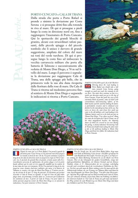
PORTO CUNCATO e CALA DI TRANA<br />
Dalla strada che porta a Porto Rafael si<br />
prende a sinistra la deviazione per Costa<br />
Serena e si prosegue dritti fino alla rotonda<br />
in riva al mare. Di qui si prosegue a piedi<br />
lungo la costa in direzione nord est, fino a<br />
raggiungere l’insenatura di Porto Cuncato.<br />
Qui lo spettacolo dei grandi blocchi di<br />
granito, alcuni con straordinari tafoni passanti,<br />
delle piccole spiagge e del piccolo<br />
tombolo che li unisce è davvero di grande<br />
suggestione, ampliata dal colore del mare<br />
sui toni del verde turchese. Di qui si prosegue<br />
lungo la costa fino ad imboccare la<br />
vecchia carrareccia militare che porta alla<br />
batteria di Talmone e successivamente alla<br />
vedetta di Monte Don Diego, a 78 m sul livello<br />
del mare. Lungo il percorso è segnalata<br />
la deviazione per raggiungere Cala di<br />
Trana, una delle spiagge più belle, che in<br />
primavera vede la sua alta duna ricoperta<br />
dalle fioriture delle rose di mare. Da Cala di<br />
Trana si ritorna sul medesimo percorso fino<br />
al sentiero di Monte Don Diego e seguendo<br />
le indicazioni si ritorna a Porto Cuncato.<br />
PORTO CUNCATO and CALA DI TRANA<br />
Driving down the road leading to<br />
Porto Rafael you should take a left<br />
turn towards Costa Serena, going<br />
straight on until you reach the rotunda on the<br />
sea shore. You must then continue on foot in a<br />
north east direction until you get to the bay of<br />
Porto Cuncato. From this point the view of the<br />
enormous blocks of granite, some of which with<br />
extraordinary interconnecting ‘tafoni’, of the<br />
little beaches and the sand bar linking the latter,<br />
is particularly evocative and is enhanced even<br />
further by the emerald green hues of the sea. You<br />
carry on down the coast from here until you<br />
come to the old military cart road leading to the<br />
Talmone battery and on to the look-out post on<br />
Mount Don Diego, 78 m. above sea level. Along<br />
the route the deviation for Cala di Trana, one of<br />
the most magnificent beaches, the imposing<br />
dunes of which are covered in sea roses during<br />
the spring, is clearly indicated. On leaving Cala<br />
di Trana you should return along the same route<br />
as far as the pathway leading to Monte Don<br />
Diego and from here follow the indications back<br />
to Porto Cuncato.<br />
PORTO CUNCATO et CALA DI TRANA<br />
Depuis la route qui va à Porto Rafael, l’on prend à gauche la<br />
déviation pour Costa Serena et l’on poursuit tout droit jusqu’à<br />
la rotonde en bord de mer. De là, l’on peut continuer à pieds le<br />
long de la côte dans la direction nord-est jusqu’à la crique de Porto Cuncato.<br />
Là, le spectacle des grands blocs de granit, certains ayant subi d’extraordinaires<br />
processus de taphonomie, des petites plages et de la petite<br />
bande sableuse qui les unit est très suggestif, amplifié par la couleur de<br />
la mer dans des tons vert turquoise. De là, l’on poursuit le long de la côte<br />
jusqu’au vieux chemin charretier militaire qui mène à la batterie de<br />
Talmone et, ensuite, à la vigie du Mont Don Diego, à 78 mètres au-dessus<br />
du niveau de la mer. Le long du parcours, la déviation qui permet<br />
d’accéder à Cala di Trana est signalée, il s’agit de l’une des plus belles<br />
plages dont, au printemps, la haute dune est recouverte par la floraison<br />
des anémones de mer. A partir de Cala di Trana, l’on peut refaire le<br />
même parcours jusqu’au sentier du Mont Don Diego et, en suivant les<br />
indications, l’on peut retourner à Porto Cuncato.<br />
PORTO CUNCATO UND CALA DI TRANA<br />
Von der Straße aus, die nach Porto Rafael führt, biegt man<br />
nach links ab Richtung Costa Serena und fährt geradeaus bis<br />
zum Rondell am Meeresufer. Von hier aus geht es zu Fuß weiter,<br />
entlang der Küste Richtung Nordosten bis zu der Bucht von Porto<br />
Cuncato. Hier ist das Schauspiel der großen Granitblöcke, einige mit<br />
äußergewöhnlichen Tafonifelsen, der kleinen Strände und des kleinen<br />
Tombolo, (Anm. d. Ü.: Dünenstreifen) der sie vereinigt, wahrhaftig<br />
reizvoll, noch verschönert durch die verschiedenen Türkistöne des Meeres.<br />
Von hier aus geht man die Küste entlang weiter bis man auf die alte<br />
Militärstraße kommt, die zur Festung von Talmone führt und dann bis<br />
zum Aussichtspunkt von Monte Don Diego, 78 m über dem Meeresspiegel.<br />
Auf dem Weg trifft man auf ein Hinweisschild nach Cala di Trana,<br />
einer der schönsten Strände, dessen hohe Düne im Frühling von blühenden<br />
Zistrosen bedeckt ist. Von Cala di Trana aus geht man auf demselben<br />
Weg zurück, bis zum Wanderweg von Monte Don Diego und dann<br />
den Schildern nach bis Porto Cuncato.


