EN-05-Whittier-Rosemead Bike Path 03-14-13.pdf - Watershed ...
EN-05-Whittier-Rosemead Bike Path 03-14-13.pdf - Watershed ...
EN-05-Whittier-Rosemead Bike Path 03-14-13.pdf - Watershed ...

Create successful ePaper yourself
Turn your PDF publications into a flip-book with our unique Google optimized e-Paper software.
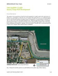
THE EMERALD NECKLACE / Phase 1 Projects <strong>03</strong>/<strong>14</strong>/2013<br />
The following are part of the <strong>Whittier</strong> Narrows Connectivity Projects, which seek to connect the<br />
Emerald Necklace to the recreation facilities in the <strong>Whittier</strong> Narrows Recreation Area.<br />
• Class I Bicycle <strong>Path</strong> from the Rio Hondo to Legg Lake: Construct a new multi-use trail<br />
through the Southern California Edison Easement and a signalized crossing at <strong>Rosemead</strong><br />
Blvd. to link the Rio Hondo <strong>Bike</strong> <strong>Path</strong> directly to Legg Lake.<br />
• Class I Bicycle <strong>Path</strong> from El Bosque Del Rio Hondo to Lincoln Avenue on San Gabriel<br />
Blvd.: Construct a Class I <strong>Bike</strong> <strong>Path</strong> on San Gabriel Blvd. to connect the north and south<br />
sections of the Rio Hondo <strong>Bike</strong> <strong>Path</strong>.<br />
• Pellissier Village Multi-Use Trail from State Highway 60 to Horseman’s Park: Improve<br />
the multi-use trail on the eastside of the San Gabriel River with a stormwater BMP<br />
component at Pellissier Village for hikers and bicyclists. Improve access ramps to the<br />
Peck Road Bridge.<br />
• Pellissier Multi-Use Bridge at Horseman’s Park: Construct a new multi-use bridge over<br />
the San Gabriel River in the Pellissier Village area that connects the existing equestrian<br />
facilities to <strong>Whittier</strong> Narrows Recreation Area and provides a safe river crossing for all<br />
trail users.<br />
The following projects have been identified for future consideration.<br />
• Provide a bicycle route on Durfee Ave. that will connect to the southern Legg Lake<br />
parking lot, The San Gabriel River Discovery Center, and South El Monte High School.<br />
Fig. 11. Durfee Ave. looking north to the east side of Legg Lake and the proposed<br />
crosswalk connection to the Lario Creek trail.<br />
ROSEMEAD BLVD. CLASS I BICYCLE PATH / DRAFT 8 of 8