Quarry Clasp Park Development Project - Watershed Conservation ...
Quarry Clasp Park Development Project - Watershed Conservation ...
Quarry Clasp Park Development Project - Watershed Conservation ...

You also want an ePaper? Increase the reach of your titles
YUMPU automatically turns print PDFs into web optimized ePapers that Google loves.
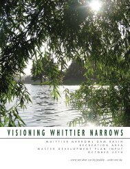
EMERALD NECKLACE / Phase 1 <strong>Project</strong>s 03/14/2013<br />
THE QUARRY CLASP:<br />
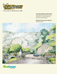
<strong>Quarry</strong> <strong>Clasp</strong> <strong>Park</strong> <strong>Development</strong><br />
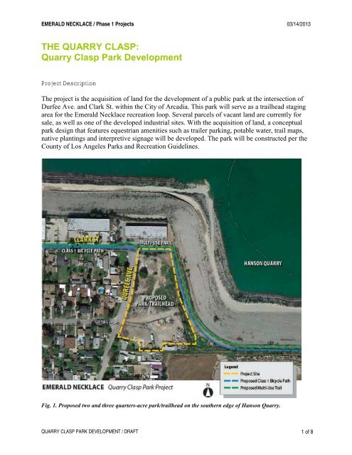
<strong>Project</strong> Description<br />
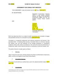
The project is the acquisition of land for the development of a public park at the intersection of<br />
Durfee Ave. and Clark St. within the City of Arcadia. This park will serve as a trailhead staging<br />
area for the Emerald Necklace recreation loop. Several parcels of vacant land are currently for<br />
sale, as well as one of the developed industrial sites. With the acquisition of land, a conceptual<br />
park design that features equestrian amenities such as trailer parking, potable water, trail maps,<br />
native plantings and interpretive signage will be developed. The park will be constructed per the<br />
County of Los Angeles <strong>Park</strong>s and Recreation Guidelines.<br />
Fig. 1. Proposed two and three quarters-acre park/trailhead on the southern edge of Hanson <strong>Quarry</strong>.<br />
QUARRY CLASP PARK DEVELOPMENT / DRAFT 1 of 8
EMERALD NECKLACE / Phase 1 <strong>Project</strong>s 03/14/2013<br />
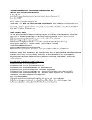
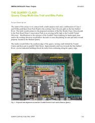
An existing equestrian trail, located in the abandoned Clark St. right-of-way, connects Durfee<br />
Ave. to the <strong>Quarry</strong>. Ownership of this approximate 14-foot wide passage is unclear at this time.<br />
The proposed <strong>Quarry</strong> <strong>Clasp</strong> Multi-Use Trail and Bike Path project assumes that continued use of<br />
the trail alignment is feasible and with the purchase of the abandoned right-of-way and additional<br />
adjacent property. Land purchase is necessary for the proposed park which will also secure trail<br />
access for both a soft-surface multi-use trail and a new Class 1 bicycle path.<br />
Fig. 2. Signed horse crossing and access trail to edge of Hanson <strong>Quarry</strong>, looking east from the<br />
intersection on Clark St. and Durfee Ave.<br />
Demolition will involve the removal of approximately 1,200 square feet of concrete driveway<br />
aprons, miscellaneous weed vegetation, and re-grading of approximately 2.75 acres.<br />
Approximately 1,600 lineal feet of 6 foot chain link fencing and gating will be removed.<br />
The new park elements will include a new concrete curb cut and drive entrance, parking space for<br />
approximately five horse trailers and five cars, bicycle racks, drinking fountain, a viewing and<br />
seating plaza approximately 100 feet by 100 feet in size, two interpretive signs, and<br />
approximately one acre of turf area. The remaining landscape would be planted with native trees<br />
and shrubs. Approximately 60 lineal feet of concrete curbing will be replaced. As this park will be<br />
utilized as a trailhead area, a restroom facility with an approximate building area of 600 square<br />
feet is recommended. Safety lighting will be associated with the building. Both dry and wet<br />
utilities will be brought into the site.<br />
The northern most end of the park will feature both a 10-foot wide multi-use trail and a 12-foot<br />
wide, asphalted and striped Class I bicycle trail. The multi-use trail will be designed and constructed<br />
per the County of Los Angeles Trails Manual. The Class I bicycle path will be designed<br />
and constructed per the CalTrans Highway Design Manual standards and AASHTO guidelines.<br />
QUARRY CLASP PARK DEVELOPMENT / DRAFT 2 of 8
EMERALD NECKLACE / Phase 1 <strong>Project</strong>s 03/14/2013<br />
Fencing will include approximately 1,600 lineal feet of 6 foot tubular steel with two 12-foot wide<br />
decorative gates to control park access. Wayfinding, regulatory, and new park entry name signage<br />
will be located adjacent to the entry parking lot.<br />
<strong>Project</strong> Site and Context<br />
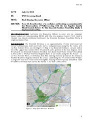
The San Gabriel River is to the east of the project area and the Peck Road Water <strong>Conservation</strong><br />
<strong>Park</strong> is located across Peck Road to the west. The San Gabriel River Trail, a Class I bicycle path,<br />
continues beyond the project area to the north and south, while the Rio Hondo Bike Path ends in<br />
the parking lot of the Peck Road Water <strong>Conservation</strong> <strong>Park</strong>. A western spur of the Bike Path ends<br />
at Live Oak Blvd. just north of the <strong>Park</strong>.<br />
Fig. 3. The project is located in the northern portion of the Emerald Necklace, a recreation trail and park<br />
system on the San Gabriel and Rio Hondo Rivers.<br />
QUARRY CLASP PARK DEVELOPMENT / DRAFT 3 of 8
EMERALD NECKLACE / Phase 1 <strong>Project</strong>s 03/14/2013<br />
The context for the project site is a combination of land-uses. Adjacent to the site are industrial<br />
properties with single family homes across the local streets. The southern edge of the Hanson<br />
<strong>Quarry</strong> extends from Peck Road to the San Gabriel River.<br />
The potential for the development of both a Class I bicycle path and an equestrian trail in the<br />
<strong>Quarry</strong> area is dependent on private land owner agreements with the Los Angeles County<br />
agencies and/or land acquisition.<br />
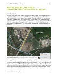
A horse crossing sign at the intersection of Durfee Ave. and Clark St., indicates an existing<br />
passage between two properties to the edge of the quarry. Most of Clark St., east of Durfee Ave.<br />
was vacated when residential parcels were reassembled for industrial use; the passage is the<br />
remaining remnant of the street right-of-way.<br />
Fig. 4. Existing horse access and proposed park site<br />
from Clark Street looking southeast.<br />
Fig.5. Proposed park site along Durfee Ave. looking<br />
southeast.<br />
Fig.6. East edge of proposed park site adjacent to Hanson <strong>Quarry</strong>, looking north.<br />
QUARRY CLASP PARK DEVELOPMENT / DRAFT 4 of 8
EMERALD NECKLACE / Phase 1 <strong>Project</strong>s 03/14/2013<br />
Fig. 7. View of the quarry operations looking northeast.<br />
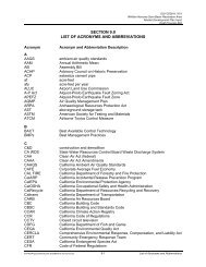
Jurisdiction<br />
<strong>Quarry</strong> <strong>Clasp</strong> project sites span both LA County District 1 (Supervisor: Gloria Molina) and<br />
District 5 (Supervisor: Michael D. Antonovich). This specific project site is within District 5 and<br />
in the City of Arcadia.<br />
Fig. 8. County Supervisor District Boundaries Map.<br />
QUARRY CLASP PARK DEVELOPMENT / DRAFT 5 of 8
EMERALD NECKLACE / Phase 1 <strong>Project</strong>s 03/14/2013<br />
Site Ownership & Easements<br />
The project area potentially encompasses 5 parcels. All five are privately owned, are not<br />
developed and are currently for sale.<br />
Los Angeles County Assessor Identification Numbers (AIN):<br />
AIN<br />
Ownership<br />
8532013026 Private<br />
8532013027 Private<br />
8532013029 Private<br />
8532014007 Private<br />
8532014002 Private<br />
Fig. 9. <strong>Project</strong> Parcel Map.<br />
Constraints<br />
• Private parcel ownership: 5 in total.<br />
• Cost of purchasing property.<br />
• Source of funding.<br />
• Obtaining approval from neighboring residents.<br />
• Obtaining permission from public agencies & utilities.<br />
QUARRY CLASP PARK DEVELOPMENT / DRAFT 6 of 8
EMERALD NECKLACE / Phase 1 <strong>Project</strong>s 03/14/2013<br />
• Obtaining approval from City of Arcadia.<br />
• Obtaining approval from 5 th District.<br />
• Impacts to habitat.<br />
• Impacts to traffic.<br />
Implementation Challenges<br />
• Public Works is developing a pipeline from Peck Road Water <strong>Conservation</strong> <strong>Park</strong> waters<br />
to the San Gabriel River. This pipeline is estimated to be built in 2014, pending funding<br />
from Water Agencies. Any easements obtained for this pipeline will not be for<br />
recreational trail purposes. Easement for trail use will require additional funding and a<br />
separate process.<br />
• The City of Arcadia may have plans for recreational improvements in this area that may<br />
conflict with the proposed improvements. Thus, the proposed project(s) should be<br />
coordinated with the City of Arcadia.<br />
Related <strong>Project</strong>s<br />
The development of a public park and trailhead on the northern edge of the Emerald Necklace<br />
will provide access to the Emerald Necklace trail system and create a neighborhood amenity. By<br />
linking the existing Rio Hondo Bike Path and the San Gabriel River Trail, a Class I bicycle path,<br />
in the City of Arcadia, the Emerald Necklace will form a complete 17-mile loop of recreation<br />
trails, greenways and park open space.<br />
The closure of the Emerald Necklace “clasp” and the completion of the recreational loop would<br />
be achieved through a series of projects located along the southern edge of the Hanson <strong>Quarry</strong>, an<br />
active gravel mining pit. Land acquisition of one or more industrial sites currently for sale would<br />
allow a large staging/parking area and green space for equestrians, bicyclers, pedestrians and<br />
hikers.<br />
The following related projects are part of the <strong>Quarry</strong> <strong>Clasp</strong> <strong>Project</strong>s:<br />
• Peck Road Signalized Crossing: A signalized crossing at the Foothill Transit traffic light<br />
on Peck Road to allow safe crossing of the street by equestrians, pedestrians and bicyclists<br />
and connect the Rio Hondo Bike Path to the San Gabriel River Trail.<br />
• <strong>Quarry</strong> <strong>Clasp</strong> Multi-Use Trail and Bike Paths: The creation of two trails (one multi-use<br />
and one bicycle trail) along the southern edge of the Hanson <strong>Quarry</strong> connecting the Rio<br />
Hondo Bike Path and the San Gabriel River Trail.<br />
• Rio Hondo Multi-Use Trail and Class I Bicycle Path Connection in Peck Road Water<br />
<strong>Conservation</strong> <strong>Park</strong>: The trails extension (one multi-use and one bicycle trail) from the<br />
north end of the parking lot of the Peck Road Water <strong>Conservation</strong> <strong>Park</strong> to the existing<br />
Foothill Transit traffic light on Peck Road, near the southwest corner of Hanson <strong>Quarry</strong>.<br />
QUARRY CLASP PARK DEVELOPMENT / DRAFT 7 of 8
EMERALD NECKLACE / Phase 1 <strong>Project</strong>s 03/14/2013<br />
Fig. 10. <strong>Quarry</strong> <strong>Clasp</strong> Phase 1 <strong>Project</strong>s include two trail alignment projects,<br />
a street crossing and the development of a park and trailhead.<br />
The following projects have been identified for future consideration.<br />
• Land acquisition would allow a land swap with a warehouse which is currently too close<br />
to the edge of the quarry and currently prevent the placement of the bicycle and multi-use<br />
trails where views are most spectacular.<br />
• <strong>Park</strong> land donation and historic quarry interpretive facilities developed by private owners<br />
for public use.<br />
• Peck Pit water line installation may provide an opportunity for trail installation over the<br />
top of the water line on the “spine” between quarries and connection east to the San<br />
Gabriel River Class I bicycle trail.<br />
QUARRY CLASP PARK DEVELOPMENT / DRAFT 8 of 8