EN-05-Whittier-Rosemead Bike Path 03-14-13.pdf - Watershed ...
EN-05-Whittier-Rosemead Bike Path 03-14-13.pdf - Watershed ...
EN-05-Whittier-Rosemead Bike Path 03-14-13.pdf - Watershed ...

You also want an ePaper? Increase the reach of your titles
YUMPU automatically turns print PDFs into web optimized ePapers that Google loves.
THE EMERALD NECKLACE / Phase 1 Projects <strong>03</strong>/<strong>14</strong>/2013<br />
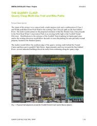
WHITTIER NARROWS CONNECTIVITY:<br />
Class I Bicycle <strong>Path</strong> on <strong>Rosemead</strong> Blvd. to Legg Lake<br />
Project Description<br />
The intent of this project is to improve recreational use from south El Bosque Del Rio Hondo to<br />
Legg Lake, and from the east end of Siphon Road to Legg Lake. This Project calls for the<br />
development a Class I bicycle path on the east side of <strong>Rosemead</strong> Blvd. from the intersection at<br />
San Gabriel Blvd. and Durfee Ave. to the southwest corner of Legg Lake, allowing bicyclists,<br />
pedestrians and hikers access to Legg Lake from the Syphon Road spur of the San Gabriel River<br />
Trail. The proposed Class I bicycle path will be located on the wide shoulder of <strong>Rosemead</strong><br />
Boulevard and will be designed to CalTrans Highway Design manual standards and AASHTO<br />
Guidelines.<br />
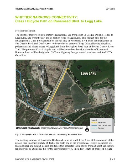
Fig. 1. The project site is located on the east shoulder of <strong>Rosemead</strong> Blvd.<br />
The existing shoulder of <strong>Rosemead</strong> Boulevard varies in width from 2 feet at the south end of the<br />
project area to approximately 28 feet at the north end of the project area. Excess stockpiled soil<br />
located under and behind a chain link fence that separates the highway from adjacent agricultural<br />
land use will be utilized as fill for the approximately 850 lineal foot length of proposed bicycle<br />
ROSEMEAD BLVD. CLASS I BICYCLE PATH / DRAFT 1 of 8
THE EMERALD NECKLACE / Phase 1 Projects <strong>03</strong>/<strong>14</strong>/2013<br />
path including the area around the existing bus stop where the existing roadway shoulder width<br />
is lacking. This area will be an encroachment into the agricultural area as the proposed bicycle<br />
path will need to avoid the existing bus stop location. Cut and fill must be balanced in this area<br />
which may result in the bicycle path being placed below the grade of the roadway in order to<br />
minimize fill. At the north end of the project area, the proposed bicycle path will meet the grade<br />
of an existing driveway into the agricultural area.<br />
The asphalted bike path will be approximately 1,900’ long, 12-foot wide, and striped to<br />
accommodate two way bicycle travel. At Legg Lake an approximately 80 foot long, 15 foot wide<br />
decomposed granite path into the <strong>Whittier</strong> Narrows Recreation Area will intersect with the<br />
internal pathways of the lake and approximately 1200 square feet of turf will be removed to<br />
accommodate the new path. Approximately 1,900 lineal feet of 6 foot fencing will be removed in<br />
order to construct the bicycle path. New fencing on both sides of the bicycle path will be<br />
required for an approximate total of 3,800 lineal feet of 54 inch tall fencing. Approximately four<br />
signs on metal posts will be removed and relocated. New signage will include two metal<br />
directional and regulatory signs on metal posts.<br />
Fig. 2. <strong>Rosemead</strong> Blvd. looking north toward Legg Lake area.<br />
Fig. 3. Trail component diagram.<br />
ROSEMEAD BLVD. CLASS I BICYCLE PATH / DRAFT 2 of 8
THE EMERALD NECKLACE / Phase 1 Projects <strong>03</strong>/<strong>14</strong>/2013<br />
Fig. 4. Existing pedestrian access to Legg Lake on <strong>Rosemead</strong> Blvd.<br />
Fig. 5 & 6. The bus stop on <strong>Rosemead</strong> Blvd. and the embankment behind it.<br />
Two benches and a posted sign indicate a bus stop close to the northeast corner of the<br />
intersection that will have to be accommodated. Alignment of the bicycle path behind the bus<br />
stop will require utilization of the stockpiled soil located directly east of <strong>Rosemead</strong> Boulevard<br />
for approximately a 150’ foot length in order to construct a new bus stop with the Class I bicycle<br />
path adjacent to it flush to the road elevation.<br />
Project Site and Context<br />
The project area is in a regional recreation setting with both developed and undeveloped<br />
parkland. Land-uses surrounding the site include agriculture—such as nurseries and cropland—<br />
and industrial and infrastructural purposes such as mineral extraction, water transfer facilities,<br />
and electrical power facilities.<br />
ROSEMEAD BLVD. CLASS I BICYCLE PATH / DRAFT 3 of 8
THE EMERALD NECKLACE / Phase 1 Projects <strong>03</strong>/<strong>14</strong>/2013<br />
The project site is located between the Rio Hondo and the San Gabriel Rivers in the <strong>Whittier</strong><br />
Narrows Recreation Area. Legg Lake is located northeast of the proposed project. <strong>Whittier</strong><br />
Narrows is both bisected and ringed with roads that are inhospitable for recreational users on<br />
bicycle or on foot; and many amenities within the <strong>Whittier</strong> Narrows Recreation Area are difficult<br />
to get to without a car. Once visitors arrive by car at Legg Lake, it is equally difficult to connect<br />
to the trails and open space attractions on the perimeter.<br />
San Gabriel Blvd. and Durfee Ave. border the project area on the south and separate the active<br />
areas of <strong>Whittier</strong> Narrows from the natural area around Lario Creek and the Zone 1 ditch. The<br />
site is adjacent to <strong>Rosemead</strong> Blvd. a State Route that is heavily used, and forms a major barrier<br />
to access into Legg Lake from the Rio Hondo side.<br />
From the San Gabriel River Trail access to the intersection at Durfee Ave. and <strong>Rosemead</strong> Blvd.<br />
is via the Siphon Road spur; the bicycle path continues on to the northern portion of the Rio<br />
Hondo <strong>Bike</strong> <strong>Path</strong> diagonally across the intersection. While the western entry to Legg Lake is in<br />
sight from this busy intersection there is no safe route to travel on except the road shoulder and<br />
emergency lane of <strong>Rosemead</strong> Blvd.<br />
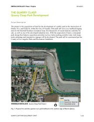
Fig. 7. The project is located in the southern portion of the Emerald Necklace, a recreation<br />
trail and park system on the San Gabriel and Rio Hondo Rivers.<br />
ROSEMEAD BLVD. CLASS I BICYCLE PATH / DRAFT 4 of 8
THE EMERALD NECKLACE / Phase 1 Projects <strong>03</strong>/<strong>14</strong>/2013<br />
Jurisdiction<br />
The project site is located within Los Angeles County District 1 (Supervisor: Gloria Molina)<br />
within unincorporated Los Angeles County.<br />
Fig. 8. County Supervisor District Boundaries Map.<br />
Site Ownership & Easements<br />
The project boundaries encompass two parcels. The US Army Corps of Engineers (USACE)<br />
owns both parcels with Southern California Edison transmission line easements on each. The<br />
Legg Lake park area is operated under a long term lease to the Los Angeles County Department<br />
of Parks and Recreation (“Parcel A”).<br />
Los Angeles County Assessor Identification Numbers<br />
AIN<br />
Ownership<br />
8119004901 USA (easement) Southern California Edison Transmission Lines<br />
81190049<strong>05</strong> USA (easement) Southern California Edison Transmission Lines<br />
ROSEMEAD BLVD. CLASS I BICYCLE PATH / DRAFT 5 of 8
THE EMERALD NECKLACE / Phase 1 Projects <strong>03</strong>/<strong>14</strong>/2013<br />
Fig. 9. Project Area Parcel Map<br />
Constraints<br />
• Obtaining permission from USACE<br />
• Obtaining permission from Caltrans<br />
ROSEMEAD BLVD. CLASS I BICYCLE PATH / DRAFT 6 of 8
THE EMERALD NECKLACE / Phase 1 Projects <strong>03</strong>/<strong>14</strong>/2013<br />
Implementation Challenges<br />
• The proposed improvements are outside of the currently permitted water conservation<br />
pool or inundation area within the <strong>Whittier</strong> Narrows Flood Control Basin. However, the<br />
U.S. Army Corps of Engineers is working on a feasibility study to allow a significantly<br />
expanded water conservation pool inundation area that will include this area. The<br />
proposed improvements should be coordinated with this study.<br />
• Los Angeles County Flood Control District’s general guidelines for maintenance, rightof-way<br />
issues, operations and landscape will be included in design and implementation.<br />
Related Projects<br />
The <strong>Rosemead</strong> Class I Bicycle <strong>Path</strong> Project is one of a series of projects in the <strong>Whittier</strong> Narrows<br />
Recreation Area that will improve connectivity of in the southern portion of the Emerald Necklace,<br />
a recreation trail and park system on the San Gabriel and Rio Hondo Rivers. The purpose of the<br />
<strong>Whittier</strong> Narrows Projects is to provide direct trail access to the heart of the <strong>Whittier</strong> Narrows<br />
Recreation Area, Legg Lake. Bicyclists and recreational users of the San Gabriel River Trail, a<br />
Class I bicycle path, and the Rio Hondo <strong>Bike</strong> <strong>Path</strong> traveling to <strong>Whittier</strong> Narrows cannot connect to<br />
this popular park unless they travel in traffic at road grade along busy <strong>Rosemead</strong> Blvd. or Durfee<br />
Road.<br />
Fig. 10. <strong>Whittier</strong> Narrows Connectivity Phase I Projects Location Map.<br />
ROSEMEAD BLVD. CLASS I BICYCLE PATH / DRAFT 7 of 8
THE EMERALD NECKLACE / Phase 1 Projects <strong>03</strong>/<strong>14</strong>/2013<br />
The following are part of the <strong>Whittier</strong> Narrows Connectivity Projects, which seek to connect the<br />
Emerald Necklace to the recreation facilities in the <strong>Whittier</strong> Narrows Recreation Area.<br />
• Class I Bicycle <strong>Path</strong> from the Rio Hondo to Legg Lake: Construct a new multi-use trail<br />
through the Southern California Edison Easement and a signalized crossing at <strong>Rosemead</strong><br />
Blvd. to link the Rio Hondo <strong>Bike</strong> <strong>Path</strong> directly to Legg Lake.<br />
• Class I Bicycle <strong>Path</strong> from El Bosque Del Rio Hondo to Lincoln Avenue on San Gabriel<br />
Blvd.: Construct a Class I <strong>Bike</strong> <strong>Path</strong> on San Gabriel Blvd. to connect the north and south<br />
sections of the Rio Hondo <strong>Bike</strong> <strong>Path</strong>.<br />
• Pellissier Village Multi-Use Trail from State Highway 60 to Horseman’s Park: Improve<br />
the multi-use trail on the eastside of the San Gabriel River with a stormwater BMP<br />
component at Pellissier Village for hikers and bicyclists. Improve access ramps to the<br />
Peck Road Bridge.<br />
• Pellissier Multi-Use Bridge at Horseman’s Park: Construct a new multi-use bridge over<br />
the San Gabriel River in the Pellissier Village area that connects the existing equestrian<br />
facilities to <strong>Whittier</strong> Narrows Recreation Area and provides a safe river crossing for all<br />
trail users.<br />
The following projects have been identified for future consideration.<br />
• Provide a bicycle route on Durfee Ave. that will connect to the southern Legg Lake<br />
parking lot, The San Gabriel River Discovery Center, and South El Monte High School.<br />
Fig. 11. Durfee Ave. looking north to the east side of Legg Lake and the proposed<br />
crosswalk connection to the Lario Creek trail.<br />
ROSEMEAD BLVD. CLASS I BICYCLE PATH / DRAFT 8 of 8