Master Plan - Watershed Conservation Authority
Master Plan - Watershed Conservation Authority
Master Plan - Watershed Conservation Authority

Create successful ePaper yourself
Turn your PDF publications into a flip-book with our unique Google optimized e-Paper software.
Azusa River Wilderness Park Project<br />
Site Programming, Site <strong>Plan</strong>ning and<br />
Overall Site Concept Development<br />
for the El Encanto Property<br />
<strong>Watershed</strong> <strong>Conservation</strong> <strong>Authority</strong><br />
October 22, 2007<br />
BlueGreen<br />
CONSULTING
El Encanto Azusa Wilderness Park <strong>Master</strong> <strong>Plan</strong><br />
Azusa River Wilderness Park Project<br />
Site Programming, Site <strong>Plan</strong>ning and<br />
Overall Site Concept Development<br />
for the El Encanto Property<br />
<strong>Watershed</strong> <strong>Conservation</strong> <strong>Authority</strong><br />
October 22, 2007<br />
Prepared by<br />
BlueGreen Consulting<br />
Los Angeles<br />
with<br />
Withers & Sandgren, Ltd.<br />
BonTerra Consulting Inc.<br />
Alan Bernstein, AIA<br />
CalCivic Engineering<br />
i
El Encanto Azusa Wilderness Park <strong>Master</strong> <strong>Plan</strong><br />
ii
El Encanto Azusa Wilderness Park <strong>Master</strong> <strong>Plan</strong><br />
Table of Contents<br />
1.0 Introduction . . . . . . . . . . . . . . . . . . . . . . . . . . . . . . . . . . . . . . . . . . . . . . . . . . . . . . . . . . . . . . . . 1<br />
2.0 <strong>Plan</strong>ning Process . . . . . . . . . . . . . . . . . . . . . . . . . . . . . . . . . . . . . . . . . . . . . . . . . . . . . . . . . . . 3<br />
2.1 <strong>Plan</strong>ning Entities and <strong>Authority</strong> . . . . . . . . . . . . . . . . . . . . . . . . . . . . . . . . . . . . . . . . . . 3<br />
2.2 Acquisition History . . . . . . . . . . . . . . . . . . . . . . . . . . . . . . . . . . . . . . . . . . . . . . . . . . . . . . . 4<br />
3.0 El Encanto <strong>Master</strong> <strong>Plan</strong> Coordination . . . . . . . . . . . . . . . . . . . . . . . . . . . . . . . . . . . . . . . 6<br />
3.1 <strong>Plan</strong>ning Process . . . . . . . . . . . . . . . . . . . . . . . . . . . . . . . . . . . . . . . . . . . . . . . . . . . . . . . . 6<br />
3.2 Steering Committee . . . . . . . . . . . . . . . . . . . . . . . . . . . . . . . . . . . . . . . . . . . . . . . . . . . . . 6<br />
3.3 Technical Advisory Committee . . . . . . . . . . . . . . . . . . . . . . . . . . . . . . . . . . . . . . . . . . . 6<br />
3.4 Community Involvement Program . . . . . . . . . . . . . . . . . . . . . . . . . . . . . . . . . . . . . . . 7<br />
3.5 Stakeholder Presentations and Workshops . . . . . . . . . . . . . . . . . . . . . . . . . . . . . . . 8<br />
4.0 Comprehensive Site Inventory and Analysis . . . . . . . . . . . . . . . . . . . . . . . . . . . . . . . 9<br />
4.1 Location and Description of Property . . . . . . . . . . . . . . . . . . . . . . . . . . . . . . . . . . . . . 9<br />
4.2 Abounding Jurisdictions . . . . . . . . . . . . . . . . . . . . . . . . . . . . . . . . . . . . . . . . . . . . . . . . . 10<br />
4.3 Physical Site Conditions . . . . . . . . . . . . . . . . . . . . . . . . . . . . . . . . . . . . . . . . . . . . . . . . . . 12<br />
Climate . . . . . . . . . . . . . . . . . . . . . . . . . . . . . . . . . . . . . . . . . . . . . . . . . . . . . . . . . . . . . . 12<br />
Geology . . . . . . . . . . . . . . . . . . . . . . . . . . . . . . . . . . . . . . . . . . . . . . . . . . . . . . . . . . . . . 12<br />
Soils . . . . . . . . . . . . . . . . . . . . . . . . . . . . . . . . . . . . . . . . . . . . . . . . . . . . . . . . . . . . . . . . . 13<br />
Geomorphology . . . . . . . . . . . . . . . . . . . . . . . . . . . . . . . . . . . . . . . . . . . . . . . . . . . . . 15<br />
San Gabriel River Hydraulics . . . . . . . . . . . . . . . . . . . . . . . . . . . . . . . . . . . . . . . . . . 19<br />
4.4 Biological Resources . . . . . . . . . . . . . . . . . . . . . . . . . . . . . . . . . . . . . . . . . . . . . . . . . . . . 23<br />
Regional Vegetation Communities . . . . . . . . . . . . . . . . . . . . . . . . . . . . . . . . . . . . 23<br />
Vegetation Types at the El Encanto Project Site . . . . . . . . . . . . . . . . . . . . . . . . 26<br />
Wildlife Populations . . . . . . . . . . . . . . . . . . . . . . . . . . . . . . . . . . . . . . . . . . . . . . . . . . 26<br />
Special Status Resources . . . . . . . . . . . . . . . . . . . . . . . . . . . . . . . . . . . . . . . . . . . . . 27<br />
Summary of Regional Biological Value . . . . . . . . . . . . . . . . . . . . . . . . . . . . . . . . 29<br />
4.5 Open-Space Connectivity . . . . . . . . . . . . . . . . . . . . . . . . . . . . . . . . . . . . . . . . . . . . . . . . 30<br />
4.6 Buildings and Structures . . . . . . . . . . . . . . . . . . . . . . . . . . . . . . . . . . . . . . . . . . . . . . . . . 31<br />
4.7 Existing Parking and Vehicle Access . . . . . . . . . . . . . . . . . . . . . . . . . . . . . . . . . . . . . . . 23<br />
4.8 Pedestrian Walking and Cycling Routes . . . . . . . . . . . . . . . . . . . . . . . . . . . . . . . . . . . 36<br />
4.9 Utilities and Other Infrastructure . . . . . . . . . . . . . . . . . . . . . . . . . . . . . . . . . . . . . . . . . 37<br />
5.0 Final Site Design <strong>Plan</strong> . . . . . . . . . . . . . . . . . . . . . . . . . . . . . . . . . . . . . . . . . . . . . . . . . . . . . . 39<br />
5.1 <strong>Plan</strong> Alternative Selection . . . . . . . . . . . . . . . . . . . . . . . . . . . . . . . . . . . . . . . . . . . . . . . 39<br />
5.2 Preferred Alternative . . . . . . . . . . . . . . . . . . . . . . . . . . . . . . . . . . . . . . . . . . . . . . . . . . . . 41<br />
5.3 <strong>Plan</strong> Components . . . . . . . . . . . . . . . . . . . . . . . . . . . . . . . . . . . . . . . . . . . . . . . . . . . . . . . . 43<br />
Setting . . . . . . . . . . . . . . . . . . . . . . . . . . . . . . . . . . . . . . . . . . . . . . . . . . . . . . . . . . . . . . 43<br />
Suggested Exterior Renovations and Style . . . . . . . . . . . . . . . . . . . . . . . . . . . . 43<br />
Building Uses . . . . . . . . . . . . . . . . . . . . . . . . . . . . . . . . . . . . . . . . . . . . . . . . . . . . . . . . . 46<br />
5.4 General Improvements . . . . . . . . . . . . . . . . . . . . . . . . . . . . . . . . . . . . . . . . . . . . . . . . . . 47<br />
Slope Stability and Drainage . . . . . . . . . . . . . . . . . . . . . . . . . . . . . . . . . . . . . . . . . . 48<br />
Special Use Area . . . . . . . . . . . . . . . . . . . . . . . . . . . . . . . . . . . . . . . . . . . . . . . . . . . . . . 49<br />
Parking Lot . . . . . . . . . . . . . . . . . . . . . . . . . . . . . . . . . . . . . . . . . . . . . . . . . . . . . . . . . . . 51<br />
San Gabriel River Banks . . . . . . . . . . . . . . . . . . . . . . . . . . . . . . . . . . . . . . . . . . . . . . . 53<br />
Habitat Restoration Activities . . . . . . . . . . . . . . . . . . . . . . . . . . . . . . . . . . . . . . . . . 56<br />
Open Space Connections and Trails . . . . . . . . . . . . . . . . . . . . . . . . . . . . . . . . . . . . 57<br />
iii
El Encanto Azusa Wilderness Park <strong>Master</strong> <strong>Plan</strong><br />
6.0 Design Guidelines . . . . . . . . . . . . . . . . . . . . . . . . . . . . . . . . . . . . . . . . . . . . . . . . . . . . . . . . . . . . 61<br />
6.1 Site Design Objectives and Guidelines . . . . . . . . . . . . . . . . . . . . . . . . . . . . . . . . . . . 61<br />
<strong>Watershed</strong> Management . . . . . . . . . . . . . . . . . . . . . . . . . . . . . . . . . . . . . . . . . . . . 61<br />
Walls . . . . . . . . . . . . . . . . . . . . . . . . . . . . . . . . . . . . . . . . . . . . . . . . . . . . . . . . . . . . . . . . 62<br />
Surfacing and Paving . . . . . . . . . . . . . . . . . . . . . . . . . . . . . . . . . . . . . . . . . . . . . . . . 62<br />
Gates and Fencing . . . . . . . . . . . . . . . . . . . . . . . . . . . . . . . . . . . . . . . . . . . . . . . . . . 62<br />
Parking Areas . . . . . . . . . . . . . . . . . . . . . . . . . . . . . . . . . . . . . . . . . . . . . . . . . . . . . . . 64<br />
Interpretive Elements . . . . . . . . . . . . . . . . . . . . . . . . . . . . . . . . . . . . . . . . . . . . . . . 64<br />
Benches and Rest Stops . . . . . . . . . . . . . . . . . . . . . . . . . . . . . . . . . . . . . . . . . . . . . 65<br />
Trash Cans and Dumpsters . . . . . . . . . . . . . . . . . . . . . . . . . . . . . . . . . . . . . . . . . . 65<br />
Drinking Fountains and Water Spigots . . . . . . . . . . . . . . . . . . . . . . . . . . . . . . . 65<br />
Picnic Tables . . . . . . . . . . . . . . . . . . . . . . . . . . . . . . . . . . . . . . . . . . . . . . . . . . . . . . . . 65<br />
6.2 Landscape and Restoration Design Objectives and Guidelines . . . . . . . . . . . 66<br />
Key <strong>Plan</strong>t Associations . . . . . . . . . . . . . . . . . . . . . . . . . . . . . . . . . . . . . . . . . . . . . . 66<br />
<strong>Plan</strong>tings in Developed Areas . . . . . . . . . . . . . . . . . . . . . . . . . . . . . . . . . . . . . . . . 67<br />
<strong>Plan</strong>tings in Parking Areas . . . . . . . . . . . . . . . . . . . . . . . . . . . . . . . . . . . . . . . . . . . 67<br />
<strong>Plan</strong>ts for Phytoremediation . . . . . . . . . . . . . . . . . . . . . . . . . . . . . . . . . . . . . . . . . 68<br />
Riparian Restoration . . . . . . . . . . . . . . . . . . . . . . . . . . . . . . . . . . . . . . . . . . . . . . . . . 68<br />
Special Status <strong>Plan</strong>ts . . . . . . . . . . . . . . . . . . . . . . . . . . . . . . . . . . . . . . . . . . . . . . . . 68<br />
Exotic <strong>Plan</strong>t Management . . . . . . . . . . . . . . . . . . . . . . . . . . . . . . . . . . . . . . . . . . . 69<br />
6.3 Architectural Objectives and Design Objectives . . . . . . . . . . . . . . . . . . . . . . . . . . 69<br />
Green Building and Sustainable Strategies . . . . . . . . . . . . . . . . . . . . . . . . . . . 69<br />
Design Style . . . . . . . . . . . . . . . . . . . . . . . . . . . . . . . . . . . . . . . . . . . . . . . . . . . . . . . . . 69<br />
Construction Materials . . . . . . . . . . . . . . . . . . . . . . . . . . . . . . . . . . . . . . . . . . . . . . 69<br />
Energy and Resouce <strong>Conservation</strong> Guidelines . . . . . . . . . . . . . . . . . . . . . . . . 71<br />
6.4 Trails and Bridge Design Guidelines . . . . . . . . . . . . . . . . . . . . . . . . . . . . . . . . . . . . . . 73<br />
Trail Materials . . . . . . . . . . . . . . . . . . . . . . . . . . . . . . . . . . . . . . . . . . . . . . . . . . . . . . . 73<br />
Trail Widths . . . . . . . . . . . . . . . . . . . . . . . . . . . . . . . . . . . . . . . . . . . . . . . . . . . . . . . . . 74<br />
Trailheads . . . . . . . . . . . . . . . . . . . . . . . . . . . . . . . . . . . . . . . . . . . . . . . . . . . . . . . . . . . 74<br />
Trail Signage . . . . . . . . . . . . . . . . . . . . . . . . . . . . . . . . . . . . . . . . . . . . . . . . . . . . . . . . 75<br />
Trail Safety . . . . . . . . . . . . . . . . . . . . . . . . . . . . . . . . . . . . . . . . . . . . . . . . . . . . . . . . . . 75<br />
River Terrace . . . . . . . . . . . . . . . . . . . . . . . . . . . . . . . . . . . . . . . . . . . . . . . . . . . . . . . . 76<br />
River Trail Bridge . . . . . . . . . . . . . . . . . . . . . . . . . . . . . . . . . . . . . . . . . . . . . . . . . . . . 76<br />
Bibliography . . . . . . . . . . . . . . . . . . . . . . . . . . . . . . . . . . . . . . . . . . . . . . . . . . . . . . . . . . . . . . . . . . . . . . 77<br />
iv
El Encanto Azusa River Wilderness Park <strong>Master</strong> <strong>Plan</strong><br />
Chapter 1:<br />
INTRODUCTION<br />
The purpose of this document is to develop a site program and design guidelines<br />
for the El Encanto property located at 100 N. Old San Gabriel Canyon Road, in the<br />
City of Azusa. This verdant 40-acre property is located at the scenic entrance to the<br />
Lower San Gabriel Canyon. The site is regionally known for its “enchanting” natural<br />
beauty and has long been considered one of the natural “crown jewels” of Southern<br />
California. Its most stunning visual feature is a sweeping canyon meander against<br />
the backdrop of the steep San Gabriel Mountains. Another notable feature of the<br />
site is the former El Encanto Restaurant structure, originally built in the 1920s to<br />
house the San Gabriel Canyon Forest Ranger.<br />
The property consists of two parcels. The smaller northern parcel (8.9 acres) is part<br />
of a large river point bar, currently in use by an equestrian training facility. The larger<br />
parcel (31 acres) lies on the southern side of the river. Approximately 3 acres of the<br />
southern parcel are developed, and the remainder is open space. The developed<br />
area includes an expansive asphalt parking lot, a mobile home park with 11 units,<br />
3 residential units, and the former restaurant building. The majority of the southern<br />
parcel (27 acres), is very steep vegetated open space.<br />
Fig. 1.1,<br />
Regional Map<br />
MORRIS<br />
RESERVOIR<br />
ANGELES NATIONAL FOREST<br />
CITY OF<br />
DUARTE<br />
SAN GABRIEL RIVER<br />
BICYCLE TRAIL<br />
GLENDORA<br />
RIDGE<br />
EL ENCANTO SITE<br />
MOTORWAY<br />
CITY OF<br />
ASUZA<br />
SANTE FE DAM<br />
RECREATION AREA<br />
210 FREEWAY<br />
1
El Encanto Azusa River Wilderness Park <strong>Master</strong> <strong>Plan</strong><br />
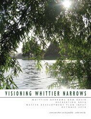
The property was purchased in February of 2006 by the <strong>Watershed</strong> <strong>Conservation</strong><br />
<strong>Authority</strong> (WCA) for inclusion into the planned Azusa River Wilderness Park. The<br />
Azusa River Wilderness Park is the vision of a larger river park that would include<br />
several parcels and a total of 89 acres. This extended park project has been<br />
receiving strong public support and has been designated a priority within the San<br />
Gabriel River Corridor <strong>Master</strong> <strong>Plan</strong>.<br />
The Azusa River Wilderness Park is of great regional importance, because it is<br />
located at one of the major gateways to Angeles National Forest. Millions of<br />
visitors pass by this location each year on their way into the mountains. On a<br />
regional scale, it is envisioned that the Azusa River Wilderness Park and the El<br />
Encanto property will connect the mountains with a multitude of projects along<br />
the San Gabriel River, the Rio Hondo, and the Los Angeles River. On a local scale,<br />
there are opportunities to connect the site to the San Gabriel River Bike Path, Fish<br />
Canyon Trail, the Forest Service Entrance Station, Roberts Creek Trail, Garcia Trail,<br />
and the Glendora Ridge Motorway.<br />
Fig. 1-2,<br />
Aerial Photo of the<br />
Azusa River Wilderness Park Vision<br />
Proposed boundaries of the<br />
Azusa River Wilderness Park<br />
El Encanto Site within the Wilderness Park<br />
S A N G A B R<br />
I E L<br />
C A N Y O N R O A D<br />
S A N<br />
G A B R<br />
I E L R<br />
I V E R<br />
2
El Encanto Azusa River Wilderness Park <strong>Master</strong> <strong>Plan</strong><br />
Chapter 2:<br />
PLANNING PROCESS<br />
2.1 <strong>Plan</strong>ning Entities and <strong>Authority</strong><br />
Implementation of the Azusa River Wilderness Park Vision has been spearheaded by<br />
the City of Azusa and the <strong>Watershed</strong> <strong>Conservation</strong> <strong>Authority</strong> (WCA). The <strong>Watershed</strong><br />
<strong>Conservation</strong> <strong>Authority</strong> is a joint powers entity of the San Gabriel & Lower Los<br />
Angeles Rivers & Mountains Conservancy (RMC) and the Los Angeles County Flood<br />
Control District (LACFCD). This partnership was established to conduct joint projects<br />
and provide comprehensive programs to expand and improve the open space and<br />
recreational opportunities within the San Gabriel and Lower Los Angeles Rivers<br />
watersheds with extended benefits to flood protection, water supply, groundwater<br />
recharge, and water conservation.<br />
The San Gabriel & Lower Los Angeles Rivers & Mountains Conservancy (RMC) was<br />
created by the California legislature in 1999. It is one of 11 conservancies within the<br />
California Resources Agency. Its mission is to preserve open space and habitat in<br />
order to provide for low-impact recreation and educational uses, wildlife habitat<br />
restoration and protection, and watershed improvement within its jurisdiction.<br />
The authorizing statute which created the RMC required formulation of a San<br />
Gabriel and Lower Los Angeles Parkway and Open Space <strong>Plan</strong>. This plan, entitled<br />
“Common Ground, from the Mountains to the Sea” is now adopted and in effect,<br />
including a grant program to distribute and administer bond funds in accordance<br />
with this plan. Funding for the program has come largely from three ballot propositions<br />
approved by California voters—Proposition 40, 50, and 84.<br />
The City of Azusa has long recognized the vital importance of the San Gabriel River.<br />
This led up to the formulation of the “Rio San Gabriel Vision <strong>Plan</strong> and Design Guidelines”<br />
to provide a framework for future restoration and watershed sensitive development<br />
of the San Gabriel River and Azusa Canyon within its incorporated boundary.<br />
The plan’s goals include facilitation of ecosystem restoration, public access to<br />
natural resources, recreational and educational opportunities and the preservation<br />
of open space and natural resources. The City of Azusa has further adopted its new<br />
“General <strong>Plan</strong>” that outlines an open space component that will restore and reconnect<br />
residents with the river. The City has recently invested in several projects along<br />
the San Gabriel River, including the US Forest Service Gateway Interpretive Center,<br />
extension of the regional bike trail along the river, and parking and staging area.<br />
In 1999, the County of Los Angeles Board of Supervisors directed the Department<br />
of Public Works to prepare the “San Gabriel River Corridor <strong>Master</strong> <strong>Plan</strong>” in order<br />
to develop a shared vision of the river. A steering committee representing cities,<br />
other public agencies, water groups, and community and environmental groups<br />
was formed to assist in the plan preparation. The San Gabriel River Corridor <strong>Master</strong><br />
<strong>Plan</strong> (SGRMP) was adopted by Los Angeles County Board of Supervisors in 2006.<br />
3
El Encanto Azusa River Wilderness Park <strong>Master</strong> <strong>Plan</strong><br />
The goal of this consensus-based document was to address and integrate multiple<br />
objectives such as flood protection, water supply, natural habitat, recreation, open<br />
space, and economic development in a guiding framework. The cities along the<br />
river are encouraged to join with the County of Los Angeles and other participating<br />
entities in implementing and planning projects to make this shared vision a<br />
reality.<br />
In summary, the planning efforts of this document are authorized and supported<br />
through inclusion of the Azusa River Wilderness Park area in the “Common<br />
Ground”, the “San Gabriel River Corridor <strong>Master</strong> <strong>Plan</strong>” and the City of Azusa’s “Rio<br />
San Gabriel Vision <strong>Plan</strong>” and General <strong>Plan</strong>.<br />
2.2 Acquisition History<br />
The first step in the creation of the Azusa River Wilderness Park was accomplished<br />
by the City of Azusa in establishing the initial boundaries and identifying the<br />
property parcels of interest. This was followed by several grant applications in 2001<br />
to purchase these properties. In October 2001, the State of California Resources<br />
Agency approved a grant to the San Gabriel and Lower Los Angeles Rivers and<br />
Fig. 2.1<br />
Azusa River Wilderness Park Study Area,<br />
Property Ownership<br />
AZUSA RIVER WILDERNESS PARK (STUDY AREA)<br />
EL ENCANTO<br />
TAYLOR PROPERTY<br />
RAINBOW RANCH EQUESTRIAN FACILITY<br />
FORMER CANYON INN PROPERTY<br />
PRIVATE PARCEL<br />
S A N<br />
G A B R I E L<br />
C A N Y O N R O A D<br />
S A N<br />
G A B R<br />
O L D S A N<br />
I E L R<br />
I V E R<br />
G A B R I E L<br />
C A N Y O N R O A D<br />
4
El Encanto Azusa River Wilderness Park <strong>Master</strong> <strong>Plan</strong><br />
Mountains Conservancy in the amount of $1 million that was made available to the<br />
City of Azusa from Proposition 13 funds. In November 2002, the City purchased the<br />
first 1.8–acre parcel, referred to as the “Taylor Property”.<br />
When the El Encanto Restaurant closed, the City of Azusa approached the RMC and<br />
WCA to evaluate the opportunity of another property acquisition for the park. In<br />
the ensuing negotiation, the WCA agreed to become the responsible agency for<br />
the grants awarded to the Azusa River Wilderness Park Project and ownership of the<br />
property acquired. The land was purchased for $3.5 million in February 2006. The<br />
initial planning efforts were made possible through a grant awarded to the WCA by<br />
the RMC.<br />
In 2007, the WCA approved a Memorandum of Understanding (MOU) between the<br />
City of Azusa and the WCA, transferring operation and maintenance of the Taylor<br />
Property to the WCA to be operated as part of the larger Azusa River Wilderness<br />
Park. The City continues to own the Taylor Property in fee. The WCA has placed<br />
the California Resource Connections, a local non-profit organization, in the Taylor<br />
House to further develop community partnerships and programs at the Azusa River<br />
Wilderness Park as well as improve the Taylor House site. The California <strong>Conservation</strong><br />
Corps (CCC) will soon have a crew working out of Taylor House as well as making it<br />
their base to recruit members and work on projects and programs on the upper San<br />
Gabriel River.<br />
Fig. 2.2<br />
The bend in the<br />
San Gabriel River<br />
at El Encanto<br />
5
El Encanto Azusa River Wilderness Park <strong>Master</strong> <strong>Plan</strong><br />
Chapter 3:<br />
EL ENCANTO MASTER PLAN COORDINATION<br />
3.1 <strong>Plan</strong>ning Process<br />
The <strong>Master</strong> <strong>Plan</strong> production was a collaborative effort that involved a variety of<br />
public entities and the public. The consultant team and the WCA developed a<br />
master plan coordination and outreach strategy that was comprised of a series of<br />
meetings and interviews to obtain direction and guidance from agencies and the<br />
public. The planning team met with regulatory agencies and evaluated zoning,<br />
easement, utility, access, and land use issues, and performed an extensive evaluation<br />
of physical and biological site conditions in order to identify opportunities<br />
and constraints of potential program elements.<br />
A Steering Committee was created to guide the planning process, and a<br />
Technical Advisory Committee (TAC) was created to provide expertise. The team<br />
coordinated three meetings with the Steering and Technical Advisory Committees<br />
as the project progressed. Each set of meetings was conducted prior to three<br />
public meetings in order to include any recommendations by the committees.<br />
Meetings were attended by team technical experts and discipline leaders.<br />
3.2 Steering Committee<br />
The purpose of the Steering Committee was to ensure that the final site concept<br />
plan reflected both the needs of the stakeholders and the mission of the WCA<br />
to the best possible extent. The very first meeting led to the formulation of the<br />
following project goals and plan objectives:<br />
Objectives<br />
Restore natural habitat.<br />
Increase connectivity to and from Angeles National Forest, other open spaces,<br />
trails, parks and river parkways.<br />
Identify opportunities for multi-purpose uses.<br />
Provide a regional portal for research, education, and interpretive resources.<br />
Integrate best management practices and sustainable design elements.<br />
List of<br />
Steering Committee<br />
Participants:<br />
RMC<br />
Belinda Faustinos<br />
Executive Officer<br />
Jane Beesley<br />
Project Manager<br />
City of Azusa<br />
Robert Person<br />
Assistant City Manager<br />
County of Los Angeles<br />
Mickey Chaudhuri<br />
<strong>Watershed</strong> Manager<br />
Jared Deck<br />
<strong>Watershed</strong> Manager<br />
US Forest Service<br />
Marty Dumpis<br />
District Ranger, ANF<br />
Army Corps of Engineers<br />
Nedenia Kennedy<br />
Chief, Environmental<br />
Policy Group<br />
List of Technical<br />
Advisory Committee<br />
Member Agencies:<br />
RMC<br />
City of Azusa<br />
County of Los Angeles<br />
US Forest Service<br />
California Department<br />
Army Corps of Engineers<br />
The Steering Committee consisted of the following agencies: Los Angeles County<br />
Department of Public Works, Lower Los Angeles and San Gabriel Rivers and Mountains<br />
Conservancy (RMC), City of Azusa, U.S. Forest Services and U.S. Army Corps of<br />
Engineers.<br />
3.3 Technical Advisory Committee<br />
The Technical Advisory Committee included the same agencies as the Steering<br />
Committee. The following additional agencies and entities were included in a<br />
series of meetings, field trips, and interviews:<br />
6
El Encanto Azusa River Wilderness Park <strong>Master</strong> <strong>Plan</strong><br />
California Department of Fish and Game<br />
California Department of Transportation<br />
Mountains Recreation and <strong>Conservation</strong> <strong>Authority</strong>, Park Rangers<br />
Sierra Club<br />
California Resource Connections<br />
City of Azusa <strong>Plan</strong>ning and Transportation Department<br />
County of Los Angeles Department of Public Works,<br />
<strong>Watershed</strong> Management Division<br />
County of Los Angeles Department of Public Works,<br />
Operations and Water Resources<br />
These agencies and interested parties provided valuable data and input to the<br />
analysis and program development. Their early involvement and understanding of<br />
the project issues and needs were critical for plan development<br />
3.4 Community Involvement Program<br />
The first step was to create a community involvement program that outlined the<br />
number, content and nature of interviews, workshops and focus group meetings,<br />
including meeting schedules and strategies to inform and notify the public. The<br />
second step was to notify the public of the stakeholder process.<br />
In cooperation with the steering committee, the team developed a list of interested<br />
individuals that had previously participated in stakeholder meetings for the San<br />
Gabriel River <strong>Master</strong> <strong>Plan</strong>. In addition, the team solicited direct support from key<br />
institutional stakeholders. Finally the team identified user groups, communities, and<br />
individual parties with special interest in the planning process who were directly<br />
notified through e-mail and phone calls.<br />
The broader public was notified through direct mailing of invitations to over 5,000<br />
residents and businesses within a defined geographic radius, announcements<br />
during televised Azusa City Council meetings, and by including announcements in<br />
the City of Azusa public newsletter.<br />
In the time leading up to the actual community meetings, the consultant team<br />
began the stakeholder process by interviewing engaged individuals and focused<br />
user groups. The objectives were to obtain a preliminary understanding of concerns<br />
and needs, and to solicit participation for successful community involvement.<br />
Owners and representatives of neighboring properties were also interviewed<br />
including the owner and manager of Rainbow Ranch, the owner and manager of<br />
the former Canyon Inn site and the property manager of the Buddhist Temple; and<br />
the future managers of the Taylor House facility.<br />
Finally, three community meetings were held consisting of presentations by team<br />
members that illustrated objectives, goals, and site opportunities and constraints.<br />
Presentations were followed by workshops or subgroup discussions to build<br />
consensus on project components.<br />
7
El Encanto Azusa River Wilderness Park <strong>Master</strong> <strong>Plan</strong><br />
3.5 Stakeholder Presentations and Workshops<br />
Three stakeholder events were held consisting of presentations by team members<br />
that illustrated objectives, goals, site opportunities and constraints. Presentations<br />
were followed by workshops or subgroup discussions to build consensus on project<br />
components.<br />
Community Meeting #1 November 2006<br />
The consultant team presented existing conditions of the El Encanto Site and<br />
summarized the vision for the Azusa River Wilderness Park. The planning process<br />
and schedule was described. Major themes in the discussions included the<br />
following:<br />
Visioning for long-term use and enhancement of the project area.<br />
Restoration of natural habitat lost due to urban encroachment.<br />
Flooding, vector, and security issues.<br />
Increasing connectivity to other open spaces, trails, and parks within the<br />
adjacent communities and drawing design inspiration from the local<br />
surrounding area.<br />
Elimination of conflicts between park users and vehicles through improved<br />
circulation of pedestrian, bicycle and vehicular traffic.<br />
Benefits of water quality improvement and promoting community<br />
participation in National Pollution Discharge Elimination System (NPDES).<br />
A series of three questionnaires were distributed and collected. Information<br />
and data was collected and later organized for analysis of preferred project<br />
components.<br />
Community Meeting #2 February 2007<br />
Three design alternatives were presented and each illustrated with photographs<br />
and illustrative plans. Components of each plan were described.<br />
Habitat Restoration Alternative<br />
Visitor Services Alternative<br />
Nature Experience Alternative<br />
Meeting participants were asked to comment and vote on the three alternatives,<br />
and to provide feedback on individual plan components. The preferred alternative<br />
selected by the meeting participants was the “Nature Experience”.<br />
Community Meeting #3 May 2007<br />
The “Nature Experience” preferred alternative was presented with additional<br />
detail. Five focus areas of the plan were presented through photographs and<br />
plan drawings. The consultants led a discussion of the selection process and plan<br />
components. Comments were taken, postcards were passed out to solicit further<br />
mail-in comments.<br />
Following each meeting, additional material, plans and diagrams were posted on<br />
the WCA’s website, along with the project managers contact information.<br />
8
El Encanto Azusa River Wilderness Park <strong>Master</strong> <strong>Plan</strong><br />
Chapter 4:<br />
COMPREHENSIVE SITE INVENTORY AND ANALYSIS<br />
4.1 Location and Description of Property<br />
The Azusa River Wilderness Park is located in the southern San Gabriel Mountains<br />
at the border to Angeles National Forest. The dominant physical feature of the site<br />
is a deeply incised canyon meander of the San Gabriel River. The watershed area<br />
above the site is approximately 220 square miles of rugged mountainous terrain<br />
with steep drainage divides and a maximum elevation of 10,064 feet at Mount<br />
San Antonio (Mt. Baldy), the highest peak in the area. The San Gabriel Mountains<br />
upstream of the site are a complex mix of igneous and metamorphic rock units that<br />
are highly fractured, faulted, and tectonically active. Downstream of the site, the<br />
river extends south through the San Gabriel Valley past Whittier Narrows, before<br />
entering the coastal plain and joining the Pacific Ocean between Long Beach and<br />
Seal Beach.<br />
The El Encanto property is surrounded by open space with a few scattered developments<br />
on adjacent parcels. Notable topography of the property includes a portion<br />
of a river point bar, a rocky alluvial river channel, an elevated terrace above the river<br />
and steep hillsides to the south with elevations ranging between 820 and 1,400 feet<br />
above sea level. The project site is located on the United States Geological Survey<br />
(USGS) Azusa, California 7.5 minute Topographic Quadrangle.<br />
LOS ANGELES COUNTY (UNINCORPORATED)<br />
ANGELES NATIONAL FOREST<br />
CITY OF AZUSA<br />
Fig. 4.1<br />
Study Area and<br />
Surrounding Properties<br />
RAINBOW RANCH<br />
EQUESTRIAN FACILITIES<br />
TAYLOR PROPERTY<br />
CANYON INN PROPERTY<br />
MOUNTAIN COVE<br />
DEVELOPMENT<br />
SAN GABRIEL<br />
RIVER<br />
BUDDHIST<br />
MONASTERY<br />
SAN GABRIEL<br />
CANYON<br />
ROAD<br />
- HWY<br />
39<br />
EL ENCANTO<br />
GLENDORA<br />
RIDGE<br />
MOTOR<br />
WAY<br />
CITY OF GLENDORA<br />
9
El Encanto Azusa River Wilderness Park <strong>Master</strong> <strong>Plan</strong><br />
The property consists of two parcels. The smaller northern parcel (8.9 acres) is<br />
part of the point bar and is currently leased to an equestrian training facility.<br />
The larger parcel (27acres) lies on the southern side of the river. Approximately<br />
3 acres of the southern parcel are developed, and the remainder is open space.<br />
Several structures exist on the site, most notably the former El Encanto Restaurant<br />
structure. The original structure was built in the 1920s as “Camp One” to house<br />
the San Gabriel Canyon Forest Ranger and has been expanded and remodeled<br />
multiple times in a piecemeal of styles. The developed area also includes an<br />
expansive asphalt parking lot, a mobile home park with 12 units, an apartment<br />
unit attached to the former restaurant via a breezeway, and a separate duplex<br />
currently housing a park ranger.<br />
Adjacent property owners include the Buddhist Monastery, the Rainbow Ranch<br />
equestrian training facility, the former “Canyon Inn Property”, currently owned<br />
by a Christian organization. The bordering slopes to the south are undeveloped<br />
lands owned by the City of Pasadena. The south eastern corner of the property is<br />
adjacent to the Angeles National Forest. Notable surrounding properties are the<br />
historic Taylor House, next to the equestrian training facility, which was acquired<br />
through the Rivers and Mountains Conservancy and is now owned by the City of<br />
Azusa. This property will be made available for public use in the future. Another<br />
neighboring area is the Mountain Cove gated community, perched on top of an<br />
alluvial fan at the mouth of Roberts Canyon.<br />
4.2 Abounding Jurisdictions<br />
Many important jurisdictional areas and boundaries are located near or close to<br />
the park site. Federal agency stakeholders are the National Forest Service, owning<br />
the vast majority of land north of the property. The Army Corps of Engineers owns<br />
Fig. 4.2<br />
California Fish & Game<br />
has jurisdiction of the<br />
conservation easement on<br />
the former Canyon Inn Site<br />
10
El Encanto Azusa River Wilderness Park <strong>Master</strong> <strong>Plan</strong><br />
and manages the flood control channel of the San Gabriel River just one mile below<br />
the site. They also have a mandated interest in the management of the dams and<br />
channels upstream and have jurisdiction over any changes to the stream channel at<br />
the site.<br />
The State of California Department of Transportation has jurisdiction over State<br />
Highway 39 and the bridge across the San Gabriel River. California Department<br />
of Fish and Game has jurisdiction over the biological resources of the stream and<br />
holds an adjacent conservation easement in the river channel and along the banks<br />
just downstream of the site. (Fig. 4.2) The State Water Resources Control Board and<br />
Regional Water Quality Control Board have jurisdiction on matters related to water<br />
conservation and water quality at the site.<br />
The channel at the site is owned and operated by the County of Los Angeles Flood<br />
Control District. Morris Dam is owned by the Metropolitan Water District (MWD) and<br />
managed and operated by the County of Los Angeles Flood Control District.<br />
The project site is located in the City of Azusa which has jurisdiction over a variety<br />
of important property issues including zoning and building safety. Figure 4.3 shows<br />
Fig. 4.3<br />
Zoning Map of north portion<br />
of the City of Azusa<br />
11
El Encanto Azusa River Wilderness Park <strong>Master</strong> <strong>Plan</strong><br />
the current Azusa zoning map. The eastern property boundary touches both, the<br />
City of Glendora, and County of Los Angeles unincorporated area. The property<br />
access road leading through the parking lot is owned by the City of Azusa, and the<br />
dirt road continuing to the County Gaging Station is a county road, maintained by<br />
the County. (see Appendix A for Maps of Jurisdictional Boundaries)<br />
4.3 Physical Site Conditions<br />
Climate<br />
The climate of the area is temperate and semi-arid with warm, dry summers and<br />
mild, moist winters. Higher elevations tend to have more moderate summers and<br />
colder winters with significant amounts of precipitation including snow in winter.<br />
The majority of rainfall occurs between the months of December and March.<br />
Extended rainless periods in the summer months are common.<br />
The majority of rainfall events in the area result from winter storms that are associated<br />
with extra-tropical cyclones originating in the North Pacific. The mean annual<br />
precipitation of the area is about 21 inches. Snow is common above 6000 feet. The<br />
average daily minimum and maximum temperatures in winter range from about<br />
44 to 62 degrees Fahrenheit. Summer average daily minimum and maximum are<br />
around 68 and 91. All-time low and high extremes of temperature are 23 and 110<br />
degrees Fahrenheit, respectively (Department of Commerce, NOAA, 2002, 2004).<br />
(see Appendix B1 for more detailed climate information)<br />
Geology<br />
The El Encanto Property is situated in the southeastern portion of the San<br />
Gabriel Mountains within the central part of the Transverse Range Province. The<br />
San Gabriel Mountains are bounded to the north by the active right-lateral San<br />
Andreas fault separating the San Gabriel Mountains from the Mojave Desert and<br />
the San Bernardino Mountains to the east. In the south, the San Gabriel Mountains<br />
are bounded by a series of active left-lateral reverse faults. These faults include<br />
the Cucamonga, Sawpit Canyon, and Sierra Madre Faults. Tectonic motion along<br />
these faults, has been responsible for the ongoing uplift of the mountain range.<br />
These faults also form the boundary to the Peninsular Range Province in the south<br />
and are considered active. To the north, the San Gabriel Mountains are further<br />
dissected by another east-west trending fault, the right-lateral San Gabriel Fault.<br />
The block of the San Gabriel Mountains between the Sierra Madre and San Gabriel<br />
Fault zones consist of a set of Late Cretaceous plutons of medium-grained granitic<br />
rocks. The El Encanto property and the lower San Gabriel Canyon are located on<br />
this tectonic block. (Fig. 4.4)<br />
This granitic block of the San Gabriel Canyon is currently thrust upwards along the<br />
Sierra Madre Fault Zone. The fault zone, only less than a mile south of the property<br />
is only poorly visible, as it is currently buried under the alluvial fan deposits at the<br />
mouth of the Lower San Gabriel Canyon. The Sierra Madre fault is a reverse-thrust-<br />
12
El Encanto Azusa River Wilderness Park <strong>Master</strong> <strong>Plan</strong><br />
Fig. 4.4<br />
Fault Zones<br />
The south eastern block of the<br />
San Gabriel Mountains is bound<br />
by the San Gabriel Fault and the<br />
Sierra Madre Fault and consists<br />
of a number of Cretaceous<br />
granitic plutons (source: Morton<br />
and Miller, 2003, USGS Open-<br />
File Report 03-293, sheet 5)<br />
ing fault where the larger granitic block is sliding upward and above the valley<br />
deposits, and over the margins of the Peninsular Range Province to the south.<br />
During the intrusion of the plutons, the former geologic base was moved upwards<br />
and towards the north. Remnants of these units are still present and are visible as a<br />
patchwork of old Proterozoic metamorphic rocks north of the property. (Fig. 4.5)<br />
Soils<br />
The soils of the southern San Gabriel Mountains are part of the larger CIENEBA-<br />
EXCHEQUER-SOBRANTE soil unit. On steep slopes of granitic rocks, soils generally<br />
fall into the Cieneba series. These are very shallow, somewhat excessively drained<br />
soils that formed in weathered materials of the parent rock. Cieneba soils occur on<br />
uplands with slopes between 9 to 85 percent.<br />
The detailed Soil Survey Geographic (SSURGO) Database for the vicinity of the<br />
El Encanto property shows two dominant soil units. On the densely vegetated<br />
north-facing slopes we find Mollisols of the Tollhouse-Stukel-Wrentham families.<br />
On the south-facing exposed slopes of the area we find Entisols of the Vista-Trigo,<br />
granitic substratum-Modesto families. Since both soil units have developed within<br />
the weathering products of the underlying cretaceous tonalite it appears that the<br />
primary genetic difference between the two are related to climatic exposure.<br />
The Mollisols at the site are characteristic of a dry Mediterranean climate. In<br />
Southern California they are commonly associated with annual grasses, oak species,<br />
and California Chapparal on steep slopes. At the project site this is the case on the<br />
steep north-facing slopes behind the existing buildings. Shaded from late afternoon<br />
exposure by the sun they enjoy a moister and cooler meso-climatic environment<br />
allowing for the development of dense chaparral. Accumulation of leaf litter<br />
ultimately leads to the formation of darker, organic-rich top horizons among the<br />
otherwise shallow and coarse soils of the surrounding area.<br />
13
El Encanto Azusa River Wilderness Park <strong>Master</strong> <strong>Plan</strong><br />
Geologic Map of the El Encanto Area<br />
Geologic Units:<br />
Qw<br />
Very young wash deposits (late Holocene)<br />
Qyf5<br />
Young alluvial-fan deposits, Unit 5 (late Holocene)<br />
Qyf3<br />
Young alluvial-fan deposits, Unit 3 (middle Holocene)<br />
Qvoa<br />
Very old alluvial-valley deposits (middle to early Pleistocene)<br />
Qls<br />
Very young landslide deposits (late Holocene)<br />
MzPb L<br />
Mixed metamorphic and granitic rocks of Big Dalton Canyon<br />
(Mesozoic and Proterozoic)<br />
Ksgr<br />
Tonalite of San Gabriel Reservoir (Cretaceous)<br />
Biotite-hornblende tonalite, ranging to granodiorite and<br />
quartz-bearing diorite. Forms east-west elongate body at front<br />
of San Gabriel Mountains on both sides of San Gabriel Canyon.<br />
Kgl<br />
Mixed leucocratic and granitic rocks (Cretaceous)<br />
Leucocratic dike rocks. Intrude Cretaceous quartz diorite and<br />
older rocks between San Gabriel and San Antonio Canyons<br />
TR lq<br />
Porphyritic quartz monzonite and quartz monzodiorite<br />
(Triassic)<br />
Pgn L<br />
Layered gneiss, undifferentiated (Proterozoic)<br />
Thinly layered, fine-grained gneiss probably derived from<br />
texturally diverse volcanic, fine grained intrusive, and<br />
immature sedimentary protoliths.<br />
14
El Encanto Azusa River Wilderness Park <strong>Master</strong> <strong>Plan</strong><br />
Fig. 4.5, left<br />
Geologic Map (Source: Morton<br />
and Miller, 2003, USGS Open-<br />
File Report 03-293)<br />
Conversely, the Entisols of the south-facing slopes experience a dryer and hotter<br />
environment with less dense vegetation. This results in higher erosion rates, less<br />
overall soil development, and the lack of organic top horizons on the otherwise<br />
identical parent material of sandy-skeletal regolith of decomposed granite.<br />
Entisols of the Vista Family<br />
Order: Entisols<br />
Suborder: Orthents<br />
Greatgroup: Xerorthents<br />
Subgroup: Typic Xerorthents<br />
Family: Coarse-loamy, mixed, thermic Typic Xerorthents<br />
Phase: Vista-Trigo, granitic substratum-Modesto families complex,<br />
40 to 70 percent slopes Soil Series: Vista family<br />
Mollisols of the Tollhouse Family<br />
Order: Mollisols<br />
Suborder: Xerolls<br />
Greatgroup: Haploxerolls<br />
Subgroup: Entic Haploxerolls<br />
Family: Loamy, mixed, mesic, shallow Entic Haploxerolls<br />
Phase: Tollhouse-Stukel-Wrentham families complex, 60 to 90 percent slopes<br />
Soil Series: Tollhouse family<br />
Geomorphology<br />
The general geomorphology of the study area is that of an incised, bedrockcontrolled<br />
canyon meander. The formation of this incised meander is due to<br />
massive tectonic uplift of the south eastern granitic block of the San Gabriel<br />
Mountains. The formation of the canyon topography is antecedent to tectonic<br />
uplift where the rate of down cutting of the canyon is approximately equal in<br />
magnitude to the tectonic uplift.<br />
Approximately 1 mile downstream of the study site the stream transitions into a<br />
large alluvial fan complex forming the margin of the San Gabriel Mountains. This<br />
foothill region is a large deposition area for immense volumes of river gravels<br />
that have historically been weathered and eroded in the mountains, transported<br />
through the canyons, and deposited over the Sierra Madre Fault Zone in the form<br />
of alluvial fans.<br />
While the channel base is near bedrock, there are substantive alluvial gravel<br />
deposits stored within the canyon bottom. These are commonly reworked and<br />
redistributed throughout the canyon floor by fluvial sediment transport during<br />
floods. The resulting channel morphology is a string of larger gravel bars flanking<br />
the main channel. In the wider and more curved portions of the canyon, a complex<br />
meander topography has evolved that includes a set of large gravel-based point<br />
bars. The larger of these point bars is a dominant feature of the El Encanto proper-<br />
15
El Encanto Azusa River Wilderness Park <strong>Master</strong> <strong>Plan</strong><br />
ty and the Azusa River Wilderness Park. Here, the lower San Gabriel Canyon widens<br />
greatly and a sudden drop of stream power allows for natural deposition of sandy<br />
sediments and the formation of a sandy floodplain deposit in the upper portions<br />
of today’s equestrian area.<br />
These thick sandy deposits of the equestrian area are the only significant accumulation<br />
of sand in the area, although it appears that most of the larger gravel bars<br />
may have originally been topped by sandy deposits. These have been lost forever,<br />
as they have been slowly eroded during floods following closure of the upstream<br />
reservoirs. This is a common process in many western streams, where dam closures<br />
cut off the natural sediment supply for downstream channels. The result is that<br />
large floods erode, but do not rebuilt sandbars, a process commonly referred to<br />
as “sediment starvation”. This ultimately leads to channel degradation and vertical<br />
entrenchment of the main channel.<br />
Fig. 4.6<br />
Geomorphologic Map of the<br />
Azusa River Wilderness Park<br />
Hydraulic analyses (Appendix B3) indicate that the thalweg of the San Gabriel River<br />
may have lowered by as much as 7-10 ft since closure of Morris Dam. The negative<br />
effect of reservoir management and entrenchment of the main channel is that<br />
flood waters do not reach the high floodplain elevations anymore. Sandy bank<br />
materials, historically an important part of the riparian ecology, are disconnected<br />
from the flow, and riparian habitat becomes over-aged, because a major element<br />
in their cyclical rejuvenation – regular flooding, was eliminated.<br />
16
El Encanto Azusa River Wilderness Park <strong>Master</strong> <strong>Plan</strong><br />
The southern parcel of the El Encanto property constitutes a cut bank positioned<br />
opposite the sandy point bar. This area has originally been the location of an elongated<br />
gravel bar that was later buried by landslides originating from the southern<br />
slopes. This situation is characteristic of the lower canyon topography, where<br />
several smaller landslides can be observed impinging on the river channel, often<br />
associated with the formation of boulder riffles, where extremely large, poorly<br />
rounded clasts can be observed amidst the river channel.<br />
The landslide scar on the southern slope of the property is not very visible and is<br />
heavily vegetated indicating that this landslide may have occurred many decades<br />
to centuries ago. The materials underlying today’s mobile home area constitute<br />
the unaltered toe materials of the original landslide. ( Fig. 4.7) Within the area of<br />
the old restaurant these slide deposits were moved to make room for the buildings<br />
and the old San Gabriel Canyon Road. It appears that the majority of the material<br />
was moved towards the stream, where it is now incorporated into the base of the<br />
parking lot and the graded southern river bank.<br />
The pre-slide topography likely included a relatively large gravel bar that is now<br />
buried under the parking lot and the neighboring property. The southern stream<br />
bank is now significantly steeper and the river channel is narrower than this would<br />
be the case under natural conditions.<br />
There are indications of ongoing mudslides and debris flows emanating from the<br />
smaller drainages and historic slide scars behind the El Encanto property. Visual<br />
field inspection suggests that the majority of these slide processes are slope wash<br />
related to erosion and down cutting of drainage channels within the depositional<br />
toe materials of the ancient slide. (Fig. 4.7)<br />
Fig. 4.7<br />
Angular matrix-supported<br />
landslide deposits underlying<br />
the mobile home park and<br />
lower slopes surrounding the<br />
buildings.<br />
17
El Encanto Azusa River Wilderness Park <strong>Master</strong> <strong>Plan</strong><br />
Generally, these landslide materials tend to be well drained without finer claybearing<br />
horizons, making large-scale or “deep seated” mobilization of the landslide<br />
deposit relatively improbable. However, slopes in the area are very steep<br />
and this will always cause materials to mobilize and wash off during larger rainfall<br />
events. Nevertheless, it is highly recommended that a more detailed study of the<br />
area is performed by geotechnical experts before major project implementation.<br />
In detail, four separate drainage channels traverse the developed area of the<br />
southern parcel emanating from the historic slide scar. (Fig. 4.8) One channel<br />
passes the mobile home area to the east. The channel has cut down dramatically<br />
to the level of the old San Gabriel Canyon Road and the eastern set of mobile<br />
homes are perched above the western bank of the gully. The gully outlet across<br />
the road is blocked by materials that were removed from the road. A second drainage<br />
traverses the center of the mobile home park and enters into a large drain<br />
pipe under the access road to the mobile homes. This drain is filled-in with debris<br />
and does not function properly. The debris accumulates in the center of the trailer<br />
park and excess water runs down the driveway, where it exits onto the road.<br />
Fig. 4.8<br />
Mapped Drainages on<br />
the El Encanto Property<br />
Small images show the locations<br />
where sediment and water<br />
currently traverse the parking<br />
lot and road.<br />
2<br />
3<br />
4<br />
1<br />
18<br />
1 2 3 4
El Encanto Azusa River Wilderness Park <strong>Master</strong> <strong>Plan</strong><br />
The third drainage currently passes in-between the main building and the<br />
apartment through the breezeway. Finally, a fourth drainage passes the building<br />
structure on the west side and currently exits onto the parking lot. There are no<br />
structural improvements or channels to lead any of these drainages into the San<br />
Gabriel River.<br />
San Gabriel River Hydraulics<br />
Stream flow at the site is regulated by three dams within the watershed: Cogswell,<br />
San Gabriel, and Morris Dams. The small Cogswell Dam was built in 1934 for flood<br />
control and water conservation purposes and is located along the West Fork of the<br />
San Gabriel River. It is operated and maintained by Los Angeles County Department<br />
of Public Works (LACDPW). San Gabriel Dam, the largest of the three dams, about 5<br />
miles upstream, was completed in 1939 for water conservation purposes and is also<br />
owned by the County of Los Angeles. Finally, Morris Dam, only two miles upstream<br />
of the El Encanto property, is owned by the Metropolitan Water District (MWD). It<br />
was originally constructed by the City of Pasadena as Pine Canyon Dam in 1934 and<br />
sold to the MWD in 1935. The dam is currently operated by LACDPW but remains in<br />
ownership of the MWD.<br />
LADPW is currently working on substantially improving the outlet structures of<br />
Morris Dam (LACDPW, 2007), which are outdated and allow very little flexibility<br />
in the way water is being released. The modifications will allow LADPW to<br />
conjunctively manage reservoir discharges to efficiently conserve water at its<br />
downstream spreading grounds. It is anticipated that larger releases would stay<br />
within the historic range of outflows and would continue to fluctuate from year to<br />
year based on annual rainfall inflow<br />
About 1 mile downstream of the El Encanto Property, the Army Corps of Engineers<br />
maintains and owns the flood control channel between the Cities of Azusa and<br />
Duarte, which includes a series of 7 invert stabilizers and 10 drop structures. The<br />
trapezoidal channel with grouted rock revetments has a capacity of 98,000 cfs.<br />
Stream flow of the San Gabriel River at the El Encanto property is characterized by<br />
high flood peaks of relatively short duration, substantially moderated or delayed by<br />
upstream storage. The release patterns at Morris Dam are essentially unmanaged<br />
due to problems related to clogging of intakes by sediment. During smaller floods,<br />
the intake valves are kept closed until storm inflow is on the falling limb. Only then,<br />
once the largest load of sediments has entered the reservoir and has settled are the<br />
valves opened to reduce reservoir levels to a normal operating level. Only during<br />
the largest floods of “spillway magnitude” are the valves used as a relieve outlet<br />
when spillway flow reaches 2000 cfs. The valves are then opened to their maximum,<br />
contributing around 5,000 cfs at that moment. The result is that lower to medium<br />
flood frequencies are reduced and that floods reach their peak rapidly once Morris<br />
Reservoir is full to capacity.<br />
19
El Encanto Azusa River Wilderness Park <strong>Master</strong> <strong>Plan</strong><br />
Notable floods of record include the flood of January 18, 1916 with 40,000 cfs<br />
before closure of the dams. The two largest floods after dam closure occurred in<br />
1938 and 1969 with discharges of 65,700 cfs and 29,850 cfs, respectively. These<br />
discharges were measured at the Azusa Gaging Station just one mile upstream of<br />
the El Encanto property site. (The entire flood record is available as Appendix B3.)<br />
Since the channel along the project site is within the jurisdiction of the County of<br />
Los Angeles, any permanent conveyance structures and bridges across the San<br />
Gabriel River must satisfy the County of Los Angeles Standards for Flood Protection<br />
– in this case, the Capital Flood. The capital flood for this reach is 86,700 cfs based<br />
on a 1948-study performed for Morris Dam (LACDPW, 2007, Mr. Jared Deck)<br />
In order to develop an understanding of the implications of a flood of this magnitude,<br />
a preliminary HEC-RAS model was developed for the existing conditions. (see<br />
Appendix B3). The model for the capital flood (Fig. 4.9) shows substantial flooding<br />
across the majority of the study area and virtually the entire point bar.<br />
While a flood of this magnitude is unprecedented within the historical record of<br />
the area, it constitutes somewhat of a “worst case scenario” for planning considerations.<br />
Within the preliminary set of potential planning elements, only two components<br />
would have to adhere to the safety standards set by this flood: a potential<br />
bridge crossing, and any stream channel alterations that would change current<br />
water surface elevations.<br />
Fig. 4.9<br />
Flooding caused by the<br />
Capital Flood of 86,700 cfs.<br />
20
El Encanto Azusa River Wilderness Park <strong>Master</strong> <strong>Plan</strong><br />
For habititat restoration activities, it is important to understand the most likely<br />
extent and probabilities of more frequent flood inundations. A preliminary analysis<br />
of flood recurrence intervals was performed to obtain a better understanding of<br />
these probabilities. Since the flood record for the site is complex, and is somewhat<br />
compromised by the closure of the dams and subsequent alterations in reservoir<br />
management, it was decided to minimize statistical inference and use a graphical<br />
fit to simplify rank-ordered probabilities to represent flood recurrence intervals.<br />
This approach is generally acceptable for habitat restoration work, but additional<br />
statistical analyses may be required for engineering work. The graphical fit is<br />
shown in Figure 4.10.<br />
Fig. 4.10<br />
Suggested Flood<br />
Recurrence Intervals for<br />
<strong>Plan</strong>ning Purposes of <strong>Plan</strong><br />
Elements not requiring<br />
Capital Flood Protection.<br />
Inflow probabilities for Santa<br />
Fe Dam, approximately five<br />
miles downstream based<br />
on surface runoff models<br />
used by the Army Corps of<br />
Engineers (USACOE, 1991)<br />
are shown for comparison.<br />
Using the obtained recurrence intervals, combined with the flow model allows the<br />
calculation of the bankfull discharge and its probability. This is often considered a<br />
diagnostic tool to evaluate whether the existing channel and floodplain topography<br />
is morphologically “in-tune” with the hydraulic flow regime. Flooding is an integral<br />
part of a natural stream’s mechanics and the amount of discharge required for the<br />
initiation of flooding and its statistical frequency is considered one of the more<br />
important measures.<br />
21
El Encanto Azusa River Wilderness Park <strong>Master</strong> <strong>Plan</strong><br />
A general rule of thumb for naturally functioning streams is that they would<br />
exceed their channel capacity about every 2 years and subsequently inundate the<br />
floodplains. In semi-arid canyon environments this value is often adjusted upward<br />
to account for larger variability of discharges and more complex channel shapes<br />
and sedimentary dynamics. Using the HEC-RAS model by incrementally increasing<br />
discharge until water levels rise above the northern banks, it was determined that<br />
bankfull discharge amounts to about 22,500 cfs. Using the recurrence intervals of<br />
Figure 4.10 this would be approximately the 29-year flood.<br />
Clearly, this value is much higher than one would usually obtain in a natural<br />
system. Generally, one would expect that in a natural canyon type environment,<br />
even a large and complex point bar would be at least partially inundated every<br />
5-10 years. The observed discrepancy is likely due to the cumulative effects of the<br />
upstream dams on the sediment supply of the channel.<br />
Fig. 4.11<br />
Onset of floodplain inundation<br />
in the center of the reach at<br />
22,500cfs with an estimated<br />
recurrence interval of 29 years.<br />
22
El Encanto Azusa River Wilderness Park <strong>Master</strong> <strong>Plan</strong><br />
4.4 Biological Resources<br />
In order to describe and summarize the existing biological resources, a biological<br />
reconnaissance survey of Azusa River Wilderness Park Project Site was conducted<br />
by BonTerra Consulting in October of 2006. A search of available literature to identify<br />
special status plants, wildlife, and habitats known to occur in the vicinity of the<br />
site was conducted. The California Native <strong>Plan</strong>t Society (CNPS) Inventory of Rare<br />
and Endangered <strong>Plan</strong>ts (CIMPS 2005) and the California Department of Fish and<br />
Game (CDFG) California Natural Diversity Database (CDFG 2004) were reviewed.<br />
During the field survey, vegetation types were described and evaluated for their<br />
potential to support special status plant and wildlife species. <strong>Plan</strong>ts were identified<br />
using keys in Hickman (1993) and Munz (1974). Finally, potential biological constraints<br />
were evaluated and site specific recommendations for potential enhancement<br />
or restoration of biological resources were presented. The entire assessment<br />
is included as Appendix B2.<br />
Regional Vegetation Communities<br />
The variety of topography, soil types, slope aspects and water availability within<br />
the San Gabriel Canyon region create a range of physical habitats which support<br />
numerous plant species. Many of these species, although often different in their<br />
growth form, prefer similar habitat characteristics and are often found in recurring<br />
assemblages to form plant communities. Ten major plant communities are found<br />
within the San Gabriel Canyon area:<br />
Big-cone spruce-canyon oak forest is an open to dense forest dominated by bigcone<br />
spruce (Pseudotsuga macrocarpa) 50 to 80 feet tall over a dense canopy of<br />
canyon oak (Quercus chrysolepis). It is found scattered throughout the canyon sides<br />
at elevations generally above 2,500 feet where it occupies rocky substrates. It commonly<br />
occurs in fairly small enclaves within chaparral.<br />
White alder riparian forest is found along the upper reaches of many drainages<br />
in the San Gabriel Canyon area. This community is dominated by white alder (Alnus<br />
rhombifolia) which grows 30 to 40 feet high over a shrub understory. It typically<br />
grows along streams in bedrock-constrained, steep-sided canyons, resulting in a<br />
fairly narrow riparian corridor.<br />
23
El Encanto Azusa River Wilderness Park <strong>Master</strong> <strong>Plan</strong><br />
Fig. 4.12, left<br />
Alluvial fan scrub plant community<br />
on the river margins<br />
Fig. 4.13, above<br />
Yellow blooms on the Scalebroom,<br />
the indicator species for alluvial<br />
fan scrub<br />
Alluvial fan scrub is a shrub community characterized by harsh substrates subject<br />
to episodic flooding and scouring. It is generally restricted to broad canyon<br />
outwashes, or alluvial washes. It is found at the San Gabriel Canyon mouth where it<br />
forms open shrub vegetation within areas of bare, scoured ground in-between.<br />
Oak woodland is a plant community dominated by species of the genus Quercus.<br />
Within the San Gabriel Canyon area, this community includes coast live oak<br />
(Quercus agrifolia) which typically grows to heights of 20 to 40 feet and the somewhat<br />
smaller interior live oak and canyon oak, and forms either closed or open<br />
tree canopies. Understory vegetation varies from grassland in level areas to shrubs<br />
where topography is steeper. It may also intergrade with shrub communities.<br />
Within the San Gabriel Canyon area, oak woodland is scattered throughout and<br />
most prevalent on north-facing slopes and in drainage bottoms.<br />
Fig. 4.14, fold out<br />
Vegetation Map<br />
of Study Area<br />
Oak riparian forest is a highly related community found in the San Gabriel<br />
Canyon area as well. This community is also dominated by coast live oak (canyon<br />
oak at higher elevations). The primary difference between oak woodland and<br />
oak riparian forest is the greater availability of water in riparian situations which<br />
is expressed in a denser tree canopy and higher density of trees. There are also a<br />
greater number of hydrophytic (moisture favoring) plant species in the understory.<br />
Typical riparian trees such as western sycamore (Platanus racemosa) and willow<br />
(Salix spp.) occasionally occur as well. Oak riparian forest is best developed within<br />
broader, more level gradient drainages of the area.<br />
24
Vegetation Types<br />
BlueGrn J001 - Azusa River Park<br />
Exhibit 1<br />
PAS R:/Projects/BlueGrn/J001/Graphics/Ex_veg_110906.pdf<br />
S A N G A B R I E L R I V E R<br />
sbs<br />
dist<br />
mc<br />
mc<br />
sbs<br />
mc/clo<br />
wat<br />
dev<br />
wat<br />
dev<br />
mc/clo<br />
wat<br />
css<br />
mc/clo<br />
SAN GABRIEL CANYON<br />
Survey Area<br />
Vegetation Types<br />
css - California Sagebrush Scrub<br />
css/sbs - California Sagebrush Scrub/Scalebroom Scrub<br />
sbs - Scalebroom Scrub<br />
mc - Southern Mixed Chaparral<br />
mc/clo - Southern Mixed Chaparral/Coast Live Oak Woodland<br />
ag - California Annual Grassland<br />
sws - Southern Willow Scrub<br />
mfs - Mulefat Scrub<br />
clo - Coast Live Oak Woodland<br />
wat - Open Water<br />
rud - Ruderal<br />
rud/dist - Ruderal/Disturbed<br />
orn/dist - Ornamental/Disturbed<br />
dist - Disturbed<br />
dist/dev - Disturbed/Developed<br />
dev - Developed<br />
²<br />
300 150 0 300<br />
Feet<br />
sbs<br />
css<br />
wat<br />
mfs<br />
sws<br />
css<br />
sbs<br />
mc<br />
css<br />
rud/dist<br />
dist<br />
dist<br />
rud/dist<br />
css<br />
mc<br />
css<br />
dist<br />
sws<br />
dist<br />
dist<br />
orn/dist<br />
ag<br />
sws<br />
rud<br />
clo<br />
css<br />
orn/dist<br />
mc<br />
css/sbs<br />
css<br />
mfs<br />
mfs<br />
mc<br />
orn/dist<br />
clo<br />
dist<br />
sbs<br />
orn/dist<br />
dist/dev<br />
sws<br />
mc<br />
mfs<br />
wat<br />
sws<br />
dist<br />
sws<br />
sbs<br />
sws<br />
mc<br />
PAS D:/Projects/BlueGrn/J001/Ex_veg_110906.mxd
El Encanto Azusa River Wilderness Park <strong>Master</strong> <strong>Plan</strong><br />
Walnut woodland often intergrades with oak dominated woodlands or develops<br />
as a distinct community. This community is dominated by the southern California<br />
black walnut (Juglans californica) which grows 10 to 30 feet high. More often than<br />
not, walnut woodland in this area is highly intermixed with oak woodland and<br />
chaparral and large monotypic stands are uncommon.<br />
Southern willow scrubs are found along widely scattered reaches of several<br />
drainages throughout the area. This community is dominated by species of willow<br />
(Salix spp.) which form nearly monotypic stands due to their dense growth with an<br />
occasional cottonwood. These stands generally reach 10 to 20 feet in height with<br />
little understory vegetation.<br />
Chaparral is a shrub community composed of robust species. Within the area,<br />
a number of chaparral sub-communities are found according to their dominant<br />
plant species. These include chamise (Adenostoma fasciculatum), buck brush<br />
(Ceanothus cuneatus var. cuneatus), ceanothus (Ceanothus spp.), scrub oak (Quercus<br />
berberidifolia), interior live oak (Quercus wislizenii) and even mosaics of these<br />
depending on mixes of species and elevation. These and other shrub species form<br />
dense vegetation covers growing five to ten feet in height. The development<br />
of chaparral is pronounced over large hillside areas throughout the San Gabriel<br />
Canyon area.<br />
Coastal sage scrub is a shrubland community exhibiting less robust structure<br />
than chaparral. This plant community is dominated by California sagebrush (Artemisia<br />
californica), bush sunflower, (Encelia californica), white sage (Salvia apiana),<br />
black sage (Salvia mellifera), and California buckwheat (Eriogonum fasciculatum).<br />
It also forms dense stands which grow three to four feet in height. Within the area<br />
it is generally found in scattered patches which are highly integrated with mixed<br />
chaparral. These are primarily located in the lower elevation hillsides of the San<br />
Gabriel Canyon area.<br />
Non-native grassland is dominated by non-native annual grasses and forbs.<br />
These opportunistically growing species include brome grasses (Bromus spp.),<br />
wild oats (Avena fatua) and mustards (Brassica spp.). Characteristic of other parts<br />
of Southern California, this community became established as a result of livestock<br />
grazing and agriculture, as native vegetation is removed, sometimes by mechanical<br />
means, and replaced by more adventitious species. Non-native grassland is<br />
found throughout the area.<br />
25
El Encanto Azusa River Wilderness Park <strong>Master</strong> <strong>Plan</strong><br />
Vegetation Types at the El Encanto Project Site<br />
Vegetation types at the El Encanto property were identified and their spatial extent<br />
was mapped on an aerial photography. (Fig. 4.14) The following types were<br />
specifically identified:<br />
California Sagebrush Scrub<br />
Scalebroom Scrub<br />
Southern Mixed Chaparral<br />
California Annual Grassland<br />
Southern Willow Scrub<br />
Mule Fat Scrub<br />
Coast Live Oak Woodland<br />
Scrub and chaparral vegetation types dominate the hillsides, and also occur in the<br />
alluvial areas west of San Gabriel Canyon Road. An annual grassland patch is located<br />
in the north-central portion of the site. Riparian habitats are present along the<br />
edges of the San Gabriel River, east of San Gabriel Canyon Road. Oak woodlands<br />
are intermixed with chaparral on the hillsides throughout the southern portion<br />
of the site. Miscellaneous map classes include Open Water, Ruderal, Ornamental,<br />
Disturbed, and Developed.<br />
Wildlife Populations<br />
Wildlife populations within the San Gabriel Canyon area are diverse and abundant<br />
due to the region’s physiographic diversity, its relative isolation, and its location<br />
within and adjacent to Angeles National Forest. The San Gabriel Canyon area<br />
is likely to support healthy populations of a diverse assortment of invertebrate<br />
species based on the undisturbed nature and variety of habitats. Fair numbers<br />
of amphibians are expected to be present primarily due to the aquatic and semiaquatic<br />
habitats provided within the numerous drainages and several reservoirs.<br />
Reptile abundance and diversity are expected to be characteristic for the habitats<br />
present, (Fig. 4.15) although areas closer to urban development along the<br />
southern boundaries of the area likely to be suppressed due to edge effect.<br />
Fig. 4.15<br />
Bird use, diversity, and abundance within the San Gabriel Canyon area is expected<br />
to be high for several reasons. In general, this area provides habitat for a wide<br />
range of shrubland, woodland, forest, and riparian species that occur at varying<br />
elevations. In particular, the riparian habitats found in drainages throughout this<br />
area provide essential habitat for riparian-obligate and riparian-favoring species.<br />
In addition, a number of migratory birds use this area to move across the northern<br />
portion of the Los Angeles Basin. These include a wide spectrum of birds including<br />
songbird, waterfowl, and raptorial species.<br />
26
El Encanto Azusa River Wilderness Park <strong>Master</strong> <strong>Plan</strong><br />
Similarly, the mammalian fauna is expected to be very diverse and abundant. Perhaps,<br />
more influential on this taxa, than the diversity of habitats, is the vast open<br />
space of the Angeles National Forest. Virtually all mammalian species found in the<br />
forest (with the exception of bighorn sheep) are expected to be found in this area.<br />
Frequent observations of black bear and mountain lion in foothill communities<br />
attest to the range of species expected.<br />
Wildlife movement within the San Gabriel Canyon area takes on two major forms.<br />
First, due to the extreme intervening topography, it is logical to expect considerable<br />
movement of wildlife up and down countless drainages which connect the<br />
forest interior with the foothill areas. A rule of thumb is that the volume of movement<br />
increases with the size of watersheds. This type of movement occurs on a<br />
seasonal and more frequent basis, particularly for large mobile mammals whose<br />
full range of habitat needs are typically met over broad areas.<br />
The second major type of movement occurs across the flanks of the foothills<br />
and lower mountains, in an east-west direction. Particularly for riparian-favoring<br />
migratory birds, a corridor linking riparian habitats of lower elevations in the<br />
San Gabriel Canyon area is of high use and importance. In addition to providing<br />
essential habitat for resident riparian birds, this area contains some of the best<br />
developed riparian habitat for birds which are seasonal visitors to cismontane Los<br />
Angeles County.<br />
Wildlife populations on the site are expected to be representative of the habitat<br />
types on site. Underdeveloped portions of the site are expected to be particularly<br />
abundant in wildlife due to the diversity of plant communities and valuable river<br />
resources.<br />
Special Status Resources<br />
The San Gabriel Canyon area supports several habitat types considered sensitive<br />
by resource agencies, namely the California Department of Fish and Game (CDFG)<br />
California Natural Diversity Database (CNDDB, 2006), because of their scarcity<br />
and their being habitat for a number of state and federally listed endangered,<br />
threatened, and rare vascular plants, as well as several sensitive bird and reptile<br />
species. These communities include: oak riparian woodland, walnut woodland,<br />
southern willow scrub, coastal sage scrub and alluvial fan scrub. They are<br />
considered highest-inventory priority communities by the CDFG, indicating that<br />
they are experiencing a decline throughout their range. Sensitive species include<br />
those listed, or candidates for listing by the United States Fish and Wildlife Service<br />
(USFWS), CDFG, and California Native <strong>Plan</strong>t Soceity (CNPS) (see the biological<br />
resources report, Appendix B2 for an extensive tabulation).<br />
27
El Encanto Azusa River Wilderness Park <strong>Master</strong> <strong>Plan</strong><br />
Several special status habitats occur on the project site including: California sagebrush<br />
scrub, scalebroom scrub, southern willow scrub, mule fat scrub, and coast<br />
live oak woodland. The following is a list of special status plant and wildlife species<br />
which have been determined to have some potential, albeit low in some cases, to<br />
occur on the site based on the range of the species and the habitat available on<br />
and surrounding the site:<br />
<strong>Plan</strong>ts<br />
Greata’s aster (Aster greatae)<br />
Braunton’s milk-vetch (Astragalus brauntonii)<br />
Nevin’s barberry (Berberis nevinii)<br />
Thread-leaved brodiaea (Brodiaea filifolia)<br />
Slender mariposa lily (Calochortus clavatus var. gracilis)<br />
Plummer’s mariposa lily (Calochortus plummerae)<br />
Slender-horned spineflower (Dodecahema leptoceras)<br />
San Gabriel River dudleya (Dudleya cymosa ssp. crebrifolia)<br />
San Gabriel Mountains dudleya (Dudleya densiflora)<br />
–*thought to occur on the site<br />
Mesa horkelia (Horkelia cuneata ssp. puberula)<br />
Robinson’s pepper-grass (Lepidium virginicum var. robinsonii)<br />
Rayless ragwort (Senecio aphanactis)<br />
San Bernardino aster (Symphyotrichum defoliatum)<br />
Sonoran maiden fern (Thelypteris puberula var. sonorensis)<br />
Fig. 4.16<br />
San Gabriel River dudleya<br />
growing on a dry rock outcrop<br />
near the park entry<br />
Fig. 4.17<br />
Sonoran maiden fern along<br />
Old San Gabriel Canyon<br />
Road.<br />
28
El Encanto Azusa River Wilderness Park <strong>Master</strong> <strong>Plan</strong><br />
Wildlife<br />
Cooper’s hawk (Accipiter cooperii)<br />
Sharp-shinned hawk (Accipiter striatus)<br />
Southern California rufous-crowned sparrow (Aimophila ruficeps canescens)<br />
Coastal western whiptail (Aspidoscelis tigris stejnegeri)<br />
Santa Ana sucker (Catostomus santaanae)<br />
Yellow warbler (Dendroica petechia brewsteri)<br />
Willow flycatcher (Empidonax traillii)<br />
Southwestern pond turtle (Emys (=Clemmys) marmorata pallida)<br />
Arroyo chub (Gila orcuttit)<br />
Yellow-breasted chat (Icteria wrens)<br />
San Diego black-tailed jackrabbit (Lepus catifornicus bennettii)<br />
Big free -tailed bat (Nyctinomops macrotis)<br />
Los Angeles pocket mouse (Perognathus longimembris brevinasus)<br />
Coast (San Diego) horned lizard (Phrynosoma coronatum [blainvillii population])<br />
Coastal California gnatcatcher (Polioptila californica californica)<br />
Santa Ana speckled dace (Rhinichthys osculus ssp. 3)<br />
Coast Range newt (Taricha torosa torosa)<br />
American badger (Taxidea taxus)<br />
Two-striped garter snake (Thamnophis hammondii)<br />
Least Bell’s vireo (Vireo bellii pusillus)<br />
Of the above species, eight are either state or federally listed as threatened or<br />
endangered. The potential for these species to occur on the site is considered very<br />
low. One species, the San Gabriel River dudleya, although not a listed species, is very<br />
rare and is known to occur in the immediate vicinity of the property. Proposed plans<br />
should avoid impacts to this species if feasible.<br />
Summary of Regional Biological Value<br />
The San Gabriel Canyon and surrounding area support a rich diversity of biological<br />
resources within close proximity to urban areas. The canyon area contains habitat<br />
of rare species such as the San Gabriel bedstraw and the San Gabriel Mountains<br />
dudleya, as well as several plant communities that are CDFG highest inventory<br />
priority communities due to their restricted distribution in the Southern California<br />
region. These communities include: walnut woodland, oak riparian woodland,<br />
southern willow scrub, coastal sage scrub, and alluvial fan scrub.<br />
The major canyons of the region support well developed and diverse riparian woodlands,<br />
as well as a source of water for most, if not all, of the year. These represent<br />
important stopover and over-wintering areas for a wide variety of migratory birds<br />
and essential habitat for resident species. These canyons support seasonal and more<br />
frequent movement for wide-ranging mammals which must move over large areas<br />
to fulfill their habitat requirements.<br />
29
El Encanto Azusa River Wilderness Park <strong>Master</strong> <strong>Plan</strong><br />
Virtually all of the native biotic communities within this area are relatively undisturbed<br />
over most of their extent. As such, and because urbanization throughout<br />
much of the foothill regions has removed large expanses of these communities,<br />
those in the San Gabriel Canyon area are particularly important to the region’s<br />
natural heritage.<br />
4.5 Open-Space Connectivity<br />
A stated goal for this project is to spatially tie the El Encanto site into the existing<br />
open space and develop much needed connectivity. The project is an opportunity<br />
to connect the mountains with the multitude of projects along the San Gabriel<br />
River, the Rio Hondo and the Los Angeles River to the Pacific Ocean. (Fig. 4.18)<br />
The most important regional open space connection is the County of Los Angeles<br />
Bikeway, which runs alongside the entire San Gabriel River between the Pacific<br />
Ocean and the Lower San Gabriel Canyon in Azusa. Currently, the bikeway ends<br />
only a few hundred feet away from the project site. One of the major goals of this<br />
planning effort is to extend the bikeway to the new park site and provide further<br />
open space access through trails.<br />
This bikeway connection is of high importance because it also links the San Gabriel<br />
Mountains to many other urban park sites. It provides a link to the planned Emerald<br />
Necklace, a 17-mile loop of greenways and parks connecting 10 cities in the<br />
San Gabriel Valley along the Río Hondo and San Gabriel River. The Necklace will<br />
connect several key recreational areas including the Whittier Narrows Recreational<br />
Area, the San Gabriel River Discovery Center, Peck Park, and the future Woodland<br />
Duck Farm Park.<br />
Fig. 4.18<br />
Opportunities for local and<br />
regional trail connections.<br />
30
El Encanto Azusa River Wilderness Park <strong>Master</strong> <strong>Plan</strong><br />
Along the way, the bikeway also makes a connection to<br />
the Santa Fe Dam Recreation Area and passes by the new<br />
National Forest Service Entry Station, currently under<br />
construction at the canyon entrance.<br />
Fig. 4.19<br />
Route 39 Bridge over the<br />
San Gabriel River<br />
Other plans include the development of nature trails<br />
opposite the current bikeway through the Cities of<br />
Duarte and Azusa, effectively allowing regional trail<br />
connections to the canyons on the north side of the river,<br />
most notably, Fish Canyon and Roberts Canyon. A trail<br />
on both sides of the river would essentially extend the<br />
Emerald Necklace into the mountains. (Fig. 4.19)<br />
On the local scale, several open space and trail connections are possible. One is<br />
to improve access to the Old San Gabriel Canyon Road between the project site<br />
and the old River Gaging Station. This picturesque area along the river is of high<br />
interest to naturalists with access limited to pedestrian traffic. Another important<br />
connection would be to the Glendora Ridge Motor Way which currently follows the<br />
mountainous ridge south of the property. A trail going up to the ridge would allow<br />
a connection to other trails along the Motorway, most notably the Garcia Trail, a<br />
popular trail on the south face of the ridge in the City of Azusa.<br />
4.6 Buildings and Structures<br />
The planning efforts for this study included the development of an overall use<br />
program for the site including the buildings and all other structures of the site. (Fig.<br />
4.20) In order to determine the preliminary feasibility of some of the possible site<br />
uses, the building structure and layout had to be thoroughly evaluated. This was<br />
done by Alan Bernstein Architects, AIA + ASLA, the architectural consultants for the<br />
project. A more detailed report is attached as Appendix B4.<br />
Fig. 4.20<br />
Existing buildings<br />
MOBILE<br />
HOME<br />
PARK<br />
RESTAURANT<br />
BUILDING<br />
RESIDENTIAL<br />
APARTMENT<br />
PARKING<br />
31
El Encanto Azusa River Wilderness Park <strong>Master</strong> <strong>Plan</strong><br />
Fig. 4.21, above<br />
Original residence<br />
before conversion to a<br />
restaurant<br />
Fig. 4.22, above<br />
Entrance to the restaurant<br />
Fig. 4.23, right<br />
Back patio of restaurant<br />
The El Encanto Restaurant building was originally a two-story single-family<br />
residence in Mediterranean style with stucco walls, Spanish clay tile roof, and<br />
wood lintels over the windows. It was built with un-reinforced masonry, which<br />
was common at the time. Historic images show lawns surrounding the buildings<br />
towards the river banks. (Fig. 4.21) The structure was later turned into a restaurant<br />
and served in that function until recently.<br />
The restaurant was well known in the area and was heavily frequented on weekends,<br />
when visitors came to enjoy the food, the cool river water, and the enchanting<br />
natural beauty of the site. Increasing popularity required several structural<br />
additions to the original building, which were constructed in a patchwork of steps<br />
over a longer period of time. (Fig. 4.22) In the center of today’s structure the old<br />
un-reinforced masonry structure is still visible, seemingly entombed within the<br />
later additions.<br />
32
El Encanto Azusa River Wilderness Park <strong>Master</strong> <strong>Plan</strong><br />
Fig. 4.24<br />
Residential apartment<br />
Fig. 4.25<br />
Two-unit structure with<br />
ranger residence<br />
Today’s restaurant structure is broken up into four major rooms plus service spaces.<br />
In the rear, a patio, shaded by verdant growth of trees, forms the transition to the<br />
steep hillside. (Fig. 4.23) Smaller block retaining walls keep water from the hillside<br />
from flowing on to the patio and into the building. The perimeter square footage of<br />
the first floor of the building is 7,636 square feet, and the second floor amounts to<br />
844 square feet. The total square footage is estimated at 8,480 square feet.<br />
Next to the restaurant building is a small single residential apartment built on top of<br />
a garage. (Fig. 4.24) The structure is connected to the restaurant building by a covered<br />
breezeway or carport that also provides access to the back patio and storage<br />
areas of the restaurant. The breezeway also acts as drainage for the steep hill slope<br />
behind the structure.<br />
33
El Encanto Azusa River Wilderness Park <strong>Master</strong> <strong>Plan</strong><br />
Next to the apartment is a two-unit duplex structure that was built last. One of<br />
these units is currently used as a ranger residence. The buildings have stucco<br />
exterior, fenced back yards, and slump block retaining walls and planters in the<br />
front. (Fig. 4.25)<br />
Finally, to the east of the restaurant building, is an 11-unit mobile home park.<br />
(Fig. 4.26) Several units are in obvious disrepair and some are precariously perched<br />
above the small drainage channel to the east.<br />
4.7 Existing Parking and Vehicle Access<br />
The El Encanto Site is visually dominated by a two-acre asphalt parking lot with a<br />
600 foot-long low wall. The three-foot high slump stone wall follows the edge of<br />
the parking lot at the top of the slope. The parking lot was constructed on top of<br />
a large mass of artificial fill, presumably originating from local landslide material.<br />
This material was graded to form a large fill terrace between the restaurant site,<br />
the western property boundary and the river channel. The northern edge of the fill<br />
now constitutes an overly steep graded river bank.<br />
Fig. 4.26<br />
Mobile home<br />
34
El Encanto Azusa River Wilderness Park <strong>Master</strong> <strong>Plan</strong><br />
Fig. 4.27<br />
Access roads and parking at<br />
El Encanto<br />
Fig. 4.28<br />
Controlled access to the<br />
county road<br />
Striping for 170 parking spaces with additional<br />
space for three or four randomly parked vehicles<br />
was once used by restaurant patrons, and now is<br />
predominantly used by RMC staff, the residents of<br />
the trailer park, and the random recreational user.<br />
A triangular area at the western end of the parking<br />
lot, consisting of approximately 20 striped spaces,<br />
overlaps onto an abutting property outside the El<br />
Encanto site boundary. (Fig. 4.27)<br />
Currently, no entry gates exist and the site is openly accessible. A two lane paved<br />
access road threads through the entire parking lot from the site entrance off the<br />
San Gabriel Canyon Road/Highway 39, hugging the hillside initially, then bisecting<br />
the parking lot as it rounds the point of the hill to a swing gate located at the east<br />
edge of the asphalt. This portion of the road is maintained by the City of Azusa<br />
and the WCA, as well as the County of Los Angeles. The road then continues as<br />
an unpaved access road to the Buddhist Temple and beyond to the river gaging<br />
station. This unpaved access road is maintained by the County of Los Angeles. While<br />
“No Trespassing” signs at the gate deter the majority of visitors from using this road,<br />
it is a public county road and pedestrian access beyond the swing gate is legal. (Fig.<br />
4.28) Posted signage allows vehicles in the parking lot from dawn to dusk. Tickets<br />
are issued by the local ranger to vehicles after dusk, except for those belonging to<br />
on-site residents.<br />
35
El Encanto Azusa River Wilderness Park <strong>Master</strong> <strong>Plan</strong><br />
4.8 Pedestrian Walking and Cycling Routes<br />
A limited number of hikers and pedestrians currently use the site. Trails and<br />
trail facilities to and from the site do not exist, with the exception of the scenic<br />
unpaved county road to the old gaging station. It follows the river north past the<br />
Buddhist Temple for approximately one mile until it dead-ends at a landslide site<br />
that destroyed the old road several years ago.<br />
Cyclists avail themselves of the Class II bicycle path located along the west side<br />
of the San Gabriel Canyon Road/Highway 39. The bicycle path ends abruptly just<br />
below the former Canyon Inn property 260 yards below the entrance to the El<br />
Encanto on the east side of the highway. (Figs. 4.29 & 4.30) Crossing the highway<br />
just opposite the El Encanto entrance is hazardous due to speeding vehicles, a<br />
narrowing of the road approaching the bridge, steep grade from north to south,<br />
and road curvature that limits visibility.<br />
Fig. 4.29<br />
Existing access map<br />
Fig. 4.30<br />
End of Class II bicycle<br />
path<br />
36
El Encanto Azusa River Wilderness Park <strong>Master</strong> <strong>Plan</strong><br />
Fig. 4.33<br />
Existing utilities map<br />
Fig. 4.31<br />
Water well on far side<br />
of river<br />
Fig. 4.32<br />
Water tanks above<br />
mobile home park<br />
4.9 Utilities and Other Infrastructure<br />
The Encanto property has its own water supply from a well on the northern parcel<br />
along the river bank. (Fig. 4.31) The water runs through a pipe under the river, and<br />
is pumped to a set of water tanks just above the mobile home area. In all, there are<br />
five water tanks, of which two are currently functioning. The water is chlorinated onsite<br />
and tested daily. The pipes that leave the tank to service the buildings are above<br />
ground and follow the steep slope and are vulnerable to damage from slides, rocks,<br />
and wildlife. (Fig. 4.32)<br />
The structures on the site are not connected to the City of Azusa sewer system and<br />
rely on a set of septic tanks and leach fields. These are essentially undocumented<br />
facilities. Electrical service to the site is provided by Southern California Edison. A<br />
series of overhead utility lines extend electrical service from Highway 39 to the<br />
buildings. (Fig. 4.33) Currently, there are five street lights illuminating the parking<br />
lot, with remnants of older light fictures along the parking lot wall.<br />
37
El Encanto Azusa River Wilderness Park <strong>Master</strong> <strong>Plan</strong><br />
Phone service is provided by Verizon and a pay phone is located outside the former<br />
restaurant building. Cell phone reception is available only to Verizon subscribers.<br />
Trash service is provided by Athens Services. Two dumpsters are located in the<br />
western parking area and several metal trash canisters with domed metal lids have<br />
been placed in the parking lot and are serviced by the local park ranger.<br />
Park regulation signage is mounted in several locations around the perimeter of<br />
the parking lot. A series of no trespassing signs located near the swing gate to the<br />
county road inaccurately deter the public, as pedestrian access is allowed. An old<br />
billboard sign for the former El Encanto restaurant still exists off-site on Highway<br />
39 and a historic metal sign for the restaurant is mounted on posts in the parking<br />
lot and is designated for re-use under this plan. (Fig. 4.34)<br />
Fig. 4.34<br />
Restaurant signage<br />
in parking lot<br />
38
El Encanto Azusa River Wilderness Park <strong>Master</strong> <strong>Plan</strong><br />
CHAPTER 5:<br />
FINAL SITE DESIGN PLAN<br />
5.1 <strong>Plan</strong> Alternative Selection<br />
The stakeholder process leading up to the final plan included extensive conversations<br />
with the public, institutional stakeholders, and focus groups regarding<br />
potential or desired improvements and alternative program elements at the<br />
property site. An extensive list was created that included all suggested project<br />
elements. The list was further expanded by input from the steering committee and<br />
the technical advisory committee.<br />
Fig. 5.1<br />
The San Gabriel River,<br />
looking west to El Encanto<br />
The list was finally completed by including input and comments from the first<br />
community event meeting and by including written comments that were received.<br />
The master list of desired program elements included a wide variety of interests<br />
including passive recreation opportunities like hiking, picnicking, bird watching,<br />
and more intensive visitor oriented activities such as day spa, restaurant and<br />
educational facilities.<br />
39
El Encanto Azusa River Wilderness Park <strong>Master</strong> <strong>Plan</strong><br />
Concurrently, the consultant teams performed an existing conditions review of<br />
all relevant planning areas of the site, producing a large set of known planning<br />
requirements, as well as factual constraints and conflicts. The master list of desired<br />
planning elements was then checked against existing planning documents including<br />
the San Gabriel River Corridor <strong>Master</strong> <strong>Plan</strong> and the City of Azusa Rio Vision <strong>Plan</strong>,<br />
and the set of known constraints to determine all potential conflicts. In this step,<br />
clearly infeasible project elements were eliminated.<br />
In the next step, the consultant team broke the site into focus areas to organize<br />
and analyze opportunities and constraints with regard to the alternative placement<br />
of all desired project elements. These areas included the following:<br />
Main Building Area<br />
Mobile Home Park<br />
Parking Lot<br />
Southern River Bank<br />
Northern River Bank<br />
Fig. 5.2<br />
<strong>Master</strong> <strong>Plan</strong> Focus Areas<br />
This ultimately resulted in the tabulation of a large opportunities and constraints<br />
matrix to assist in determining how the desired project elements could be placed<br />
within the project focus areas. For instance, the matrix would list all potential<br />
locations for the placement of a picnic area, and would then indicate all factual<br />
constraints or conflicts arising out of that placement. In addition, the matrix would<br />
show all other desired planning elements that would compete with that exact<br />
placement.<br />
40
El Encanto Azusa River Wilderness Park <strong>Master</strong> <strong>Plan</strong><br />
The consultant team developed three programmatic alternatives and concept site<br />
plans that reflected the broader spectrum of potential future environmental impacts<br />
that site planning would have. Ordered from low-impact to high-impact, the<br />
following alternatives were presented to the public in the second community event<br />
meeting:<br />
Habitat Restoration Alternative<br />
The Ecological Restoration concept would focus on increasing the extent and quality<br />
of natural habitats to provide a very low impact nature experience.<br />
Nature Experience Concept Alternative<br />
The Nature Experience concept would maximize the outdoor visitor experience<br />
and provide only limited visitor services. This low-impact oriented approach would<br />
include a heavy emphasis on habitat restoration and maximize trail opportunities.<br />
Educational and interpretive displays would be located outdoors for self-guided<br />
tours.<br />
Visitor Services Alternative<br />
The Visitor Services concept would provide amenities for the greatest amount of<br />
visitors including groups and individual visitors arriving by trail, car and bus. The<br />
concept would include educational/interpretive components for visitors and school<br />
classes.<br />
During the second community meeting, all three alternatives were presented<br />
individually. The presentation of each plan was followed by discussion and<br />
comment cards, with written comments gathered at that time. After all three<br />
had been presented, the community members were given the opportunity to<br />
verbally, or in writing select their preferred alternative. After all comments for each<br />
alternative were compiled and analyzed, it was clear that the community preferred<br />
the Nature Experience alternative. The three alternative concept plans are included<br />
in Appendix A.<br />
5.2 Preferred Alternative<br />
The preferred alternative for El Encanto in the Azusa River Wilderness Park is the<br />
Nature Experience alternative. The over-riding theme of the plan is to provide<br />
a place in nature close to the city. El Encanto is an “enchanted” place on the San<br />
Gabriel River that gives the impression of being further from civilization than is<br />
actually the case. The natural beauty and scenery gives the site a tranquil retreatlike<br />
quality. Nevertheless, it is located along a State highway and one of its more<br />
visible features is an expansive asphalt parking lot.<br />
41
El Encanto Azusa River Wilderness Park <strong>Master</strong> <strong>Plan</strong><br />
The goal of this plan is to amplify the tranquil qualities by “toning down” the<br />
developed site character associated with a large parking lot that conveys the<br />
image of a service-oriented facility. This preferred alternative will allow visitors<br />
more opportunities to engage in low impact experiences and the enjoyment<br />
of natural beauty. This is not to say that the character of the facility will be less<br />
inviting, but that it will project the image of a rustic California-style park that<br />
provides trail access, rather, than being a rest stop for vehicular traffic on the way<br />
to the Upper San Gabriel Canyon.<br />
The distinct programmatic choice is to reduce services to a minimum, in<br />
exchange for access to natural open space in close proximity to the city. This will<br />
allow for some much needed relief for the heavily used trails of the Upper San<br />
Gabriel Canyon. Connecting the existing bikeway to the site, as well as, making a<br />
connection to the Glendora Ridge Motorway, is intended to create a recreational<br />
destination for users that arrive by means other than automobiles.<br />
Rich and diverse habitats of the surrounding terrain support an array of wildlife<br />
including deer, bear, fish and birds. Restoration of the river and natural environment<br />
is a local and regional planning priority. Hence, the Nature Experience theme<br />
includes a significant amount of local habitat restoration and will provide trail<br />
access that is carefully balanced within the sensitive natural areas. Educational and<br />
interpretive displays will be located along trails and outdoor areas for self-guided<br />
tours. Larger educational activities will be limited to special events within a designated<br />
special use area and a conference room within the old restaurant. Both will<br />
be made available to the public by special request.<br />
Fig. 5.3, fold out<br />
The preferred alternative,<br />
Nature Experience<br />
<strong>Master</strong> <strong>Plan</strong><br />
The plan seeks to utilize existing facilities and structures for park operations<br />
featuring energy conservation and sustainable design. More extensive public use<br />
and services will not be anticipated as this would increase day-to-day traffic. With<br />
regard to the parking lot, this plan includes a dramatic reduction of parking to<br />
provide for stream bank restoration and the construction of a river bank trail with<br />
viewing terrace to provide a more intimate, non-contact experience of the riparian<br />
environment.<br />
42
El Encanto Azusa River Wilderness Park <strong>Master</strong> <strong>Plan</strong><br />
Fig. 5.4<br />
The proposed<br />
enhancement of<br />
the old restaurant<br />
structure<br />
5.3 <strong>Plan</strong> Components<br />
Setting<br />
The main restaurant building was originally built as a two-story residential unit<br />
with un-reinforced masonry in a Spanish/Mediterranean style with a large stone<br />
fireplace, clay roof tiles, and wood lintels over the windows. Later, the structure<br />
was turned into a restaurant that was well known in the area and was heavily<br />
frequented on weekends. Increasing popularity required multiple structural<br />
additions to the original building, which were constructed in several steps. In the<br />
center of today’s structure, the old un-reinforced masonry structure is still visible,<br />
seemingly entombed within the structural additions. (Fig. 5.6) Two other buildings,<br />
an apartment over a garage, and a duplex exist on the site. Both were constructed<br />
as residential units as the restaurant operation expanded. Surface runoff from the<br />
slope above exits through the carport between the main building and the garage.<br />
All three existing buildings have unattractive stucco exteriors and lack character.<br />
Suggested Exterior Renovations and Style<br />
An upgraded façade for the structures is recommended in order to create a cohesive<br />
building complex with a unified building facade. (Fig 5.4) Integration of the three<br />
building structures will be accomplished by adding a new trellised courtyard to<br />
the area currently located in front of the garage. This will visually focus a visitor’s<br />
approach to the center of the building complex, rather than to the existing<br />
restaurant entrance.<br />
43
El Encanto Azusa River Wilderness Park <strong>Master</strong> <strong>Plan</strong><br />
Fig. 5.5<br />
Early watercolor of the<br />
original residence<br />
Fig. 5.6<br />
Existing floor plan<br />
highlighting the original<br />
residential sturcture<br />
The suggested architectural style of the building façade would be that of a<br />
Columbian farm house, which relates back to the original house in the center<br />
of the existing structure, of which several historic photos and illustrations are<br />
still available. (Fig. 5.5) The influence of Spanish/Mediterranean design and<br />
architecture is found throughout South America and the southern portion of<br />
North America through the influence of European settlers. This style utilizes the<br />
Spanish roof tile, rough stucco texture, and porch and trellis structures. (Fig. 5.7)<br />
The persistence of this style can be attributed to both the cultural and climatic<br />
environment. The sustainable architectural features of Spanish/Mediterranean<br />
buildings work remarkably well in Southern California’s climate. Thick, lightcolored<br />
stucco walls keep structures cool. Clay tiles can be made from local<br />
materials, are long-lasting, and are resistant to fires. Porches and trellis structures<br />
are particularly interesting, because they can produce a “semi-public” atmosphere<br />
in allowing exterior public access and shade.<br />
Fig. 5.7<br />
An example of a<br />
Columbian farm house,<br />
the recommended<br />
architectural precedent.<br />
44
El Encanto Azusa River Wilderness Park <strong>Master</strong> <strong>Plan</strong><br />
Fig. 5.8<br />
The covered porch<br />
and trellised courtyard<br />
The new trellised courtyard in front of the buildings will create a new building<br />
approach, and new public space along the northern exterior of the buildings. The<br />
porches and trellis structures will give the public space to gather without entering<br />
the buildings. The courtyard will offer some relief from the sun and allow for<br />
covered interpretive displays at the same time. (Fig. 5.8)<br />
Along with the changes to the windows and doors, the new design will become<br />
a beautiful backdrop to the park. Changing the color of the buildings to blend or<br />
compliment the trees behind them could also enhance the beauty of the site and<br />
move the developed visual component of the site into the background.<br />
The landscape grade in front of the buildings will have to be elevated to create<br />
the space for the courtyard. The configuration of the exterior handicap ramps will<br />
change and allow for removal of a portion of the existing retaining walls. The walls<br />
will be waterproofed from the planter or backside and proper drainage will be<br />
added. The front side of the walls will receive a stucco finish to create continuity<br />
between buildings and other landscaping features.<br />
New porch roof covers and trellis will be added in strategic locations to help change<br />
the character of the building, enabling the architect to reinterpret the existing architectural<br />
façade with the least changes to the existing structures. The result will be a<br />
45
El Encanto Azusa River Wilderness Park <strong>Master</strong> <strong>Plan</strong><br />
Fig. 5.9<br />
Building Layout <strong>Plan</strong><br />
DRAINAGE FROM HILLSIDE DIVERTED<br />
AROUND FACILITIES<br />
SERVICE DRIVEWAY TO EXISTING GARAGE<br />
PUBLIC COURTYARD<br />
WITH INTERPRETIVE DISPLAYS<br />
COVERED PORCH<br />
BACK PATIO<br />
complex of connected structures with simple façade modifications. No consumer<br />
services will be provided at the site. Services will be limited to restrooms, water<br />
and trash disposal. Self-guided outdoor educational/interpretive elements will be<br />
added to the proximity of the buildings.<br />
Sustainable and energy saving construction material and upgrades to energy<br />
systems will be integrated into building renovations. Visibility of the structures<br />
from the road will be enhanced by the façade upgrades, while new landscaping<br />
will screen portions of the building where public access is not allowed.<br />
Building Uses<br />
The main building will include space for operational offices for park staff,<br />
restrooms, storage, and conference/meeting room available for public use. The<br />
occupants will be the Rivers and Mountains Conservancy and the <strong>Watershed</strong><br />
<strong>Conservation</strong> <strong>Authority</strong>. The building is broken into four major rooms plus service<br />
spaces. In the rear of the building is a patio that is shaded by the verdant growth<br />
of trees on the hillside. Slough or retaining walls will keep water from the hillside<br />
from flowing on to the patio and into the building. The unit above the garage is<br />
to be used for operational offices for park staff. The duplex unit will be used for<br />
operational offices and living quarters for the park ranger.<br />
46
El Encanto Azusa River Wilderness Park <strong>Master</strong> <strong>Plan</strong><br />
General Improvements<br />
Fire Protection<br />
A single fire hydrant connected to the existing water tanks is located near the buildings.<br />
It is critical to design and implement fire prevention systems and strategies as<br />
a part of each park improvement. Fire resistant materials include stucco, clay roof<br />
tiles and masonry. The chimney on the building must have proper screening. Fire<br />
extinguishers should be located both inside and outside of structures and readily<br />
available for use by park employees and visitors. Each employee should have direct<br />
instruction on evacuation, safe storage of materials and safe operation of potentially<br />
flammable equipment and materials. Vegetation near structures should be<br />
open, irrigated and maintained to prevent the fire ladder condition. No open fires or<br />
smoking will be allowed on site. Signage posting these regulations shall be visible<br />
in all public areas.<br />
Trash Enclosure<br />
A trash enclosure for dumpsters will be located in the maintenance area near the<br />
current duplex unit. The enclosure will be integrated into the park environment and<br />
screened by a combination of stone and stucco walls. The enclosure will be constructed<br />
in a fashion that prevents wildlife nuisance related incidents.<br />
Parking Requirements<br />
The general area is designated as Open Space which allows for a wide variety of<br />
activities, including the adjacent horse facility and the buddhist temple. There are<br />
no set parking requirements for the park portion of the project, but the project site<br />
should allow space for at least 2 school buses that may visit the site and for truck<br />
access to the special use area.<br />
For the administrative offices, one parking space per 300 square feet is required.<br />
The total area of the building is 8480 square feet to the outside face of the walls.<br />
Approximately 33% of the building usage will be for office space. The remainder will<br />
be storage or conference facility. For storage space, one space per 2,500 square feet<br />
is required. For each residential one-bedroom apartment, one parking space with<br />
a garage is required. If all three apartments are used then 3 covered garage spaces<br />
will be required. If they are used for administrative purposes, the parking spaces can<br />
be calculated as office.<br />
Park Area<br />
Office Space<br />
Storage Space<br />
Apartments<br />
10 parking spaces, 2 school buses<br />
20 spaces<br />
1 space<br />
3 garage spaces (or modification from City)<br />
This minimum required parking estimate would be 34 car spaces and 2 bus spaces.<br />
The final parking count will have to be determined with the City of Azusa.<br />
47
ROADWAY<br />
El Encanto Azusa River Wilderness Park <strong>Master</strong> <strong>Plan</strong><br />
Fig, 5.10<br />
Schematic plan showing<br />
suggested drainage<br />
improvements.<br />
Drainage 2<br />
Day-light drainage,<br />
restore channel,<br />
construct Arizona<br />
crossing at roadway<br />
Drainage 3<br />
Construct wall<br />
and maintenance<br />
path to cut off<br />
sediment, merge<br />
with Drainage 4<br />
Drainage 1<br />
Restore Bank<br />
and construct<br />
Arizona crossing<br />
at roadway<br />
Drainage 4<br />
Day-light and<br />
restore channel,<br />
construct bridge<br />
over channel at<br />
roadway.<br />
Slope Stability and Drainage Improvements<br />
Based on a preliminary investigation of slope stability and drainage (see Appendix<br />
B1) it is highly recommended that a more detailed study of the slope area behind<br />
the buildings is performed by geotechnical experts. With regard to minor slope<br />
wash and drainage, improvements to the local drainages will be implemented to<br />
“pass” runoff and slope materials through and around the building complex, and<br />
by making improvements that facilitate management and clean-up of debris.<br />
(Fig. 5.10)<br />
Drainage 1<br />
This drainage borders the mobile home area to the east. It is suggested to retain<br />
the drainage channel in the current position and to construct a road crossing that<br />
allows sediment to cross the road and enter the San Gabriel River channel. It is<br />
suggested to use what is commonly referred to as an “Arizona Crossing”, essentially,<br />
a reinforced concrete dip in the road. It is not recommended to use a culvert,<br />
because this would lower the base level of the channel and cause more sediment<br />
mobilization and down-cutting in the upper drainage. It is suggested to lay back<br />
the western gully slope and restore, and plant part of the drainage to prevent<br />
future slope collapse. Absent re-grading of the bank slope, it is recommended to<br />
install a low barrier or fence at the top of the slope to prevent visitors to the special<br />
use area from falling into the gully.<br />
48
El Encanto Azusa River Wilderness Park <strong>Master</strong> <strong>Plan</strong><br />
Drainage 2<br />
This drainage traverses the center of the mobile home park and enters into a large<br />
drain pipe under the access road within the mobile home park. It is recommended<br />
to completely re-grade and daylight this drainage. Underground culverts are likely<br />
to fill in with debris in the future. A concrete Arizona Crossing would be the most<br />
appropriate structure to allow flood waters to traverse the road.<br />
Drainage 3<br />
This drainage traverses the main buildings through the breezeway between the<br />
restaurant building and the apartment above the garage. It is the most problematic<br />
of the four drainages. One solution is to re-route flow and sediment into the fourth<br />
drainage and only retain the breezeway as an emergency overflow channel. This<br />
would require construction of a small retaining structure or slough wall with adjacent<br />
service road that would also function as the new debris channel. The downside<br />
of this solution is that a portion of the patio and a portion of the backyards of the<br />
apartment and duplex units would be lost. Nevertheless, this type of structure will<br />
reduce maintenance cost in the long-run as sediment behind the buildings could<br />
be seasonally removed using bobcat-type machinery.<br />
Drainage 4<br />
This drainage passes the building complex on the west side and currently exits onto<br />
the parking lot. Sediment spills onto the road and parking lot. It is recommended<br />
to combine drainages 3 and 4 into one naturalized channel traversing the existing<br />
road under a small bridge. The channel would be naturalized and designed to meet<br />
the re-graded slope of the San Gabriel River. The new channel and bridge would<br />
create the planned boundary between the public parking area and the “limited access”<br />
area surrounding the buildings.<br />
Special Use Area<br />
The current mobile home park will make room for the future special use area. The<br />
area will be regraded and reshaped to a more natural hillside morphology. Infrastructure<br />
from the mobile home park, including asphalt pads and roadways, will be<br />
removed. The area will be generously planted with native vegetation. (Fig. 5.11)<br />
The special use area will have multiple uses and include picnic tables, outdoor<br />
classroom, restroom, trailhead, observation overlook with park shelter and interpretive<br />
displays. The area will be available for special group gatherings. The area will be<br />
available for these uses by special permit only. A trailhead will lead to an observational<br />
overlook either within the special use area or located along a loop-hiking trail<br />
that could traverse the slope above.<br />
49
El Encanto Azusa River Wilderness Park <strong>Master</strong> <strong>Plan</strong><br />
TRAIL AT BACK OF FACILITIES<br />
PRE-FABRICATED RESTROOM<br />
PICNIC AREAS<br />
OVERLOOK WITH PARK SHELTER<br />
AND INTERPRETIVE SIGNAGE<br />
TRAIL TO WATER TANKS AND TO LOOP TRAIL<br />
A vista park shelter will be located within the special use area. The shelter will be<br />
located near the trailhead and will provide a shaded rest stop and opportunities for<br />
orientation, way-finding, and interpretive displays. Constructed with local rock and<br />
metal beams finished to resemble heavy timbers, the shelter will have a rustic character<br />
and share style elements with the Columbian farmhouse styles of the main<br />
buildings. Clay tile roofs and rock walls will shelter visitors from sun, wind and rain.<br />
Fig. 5.11<br />
Special Use Area<br />
A pre-fabricated waterless restroom facility will be brought to the site for public<br />
use. A sanitation company will maintain this unit. The pre-fabricated restroom will<br />
be screened with walled enclosures that integrate into the park environment. The<br />
enclosures will be built with a combination of stone and stucco walls with clay roof<br />
tiles that match the other buildings.<br />
The drainage of the entire special use area will be upgraded and restored. Currently,<br />
two drainages traverse the area. A deep ravine passes the special use area near<br />
the eastern property boundary. Severe erosion has degraded the streambed and<br />
habitat, and created an unstable slope. The stream channel will be restored to a<br />
more natural form and heavily vegetated with sycamores and riparian plantings.<br />
A second drainage crosses the area through the center of the area. This drainage<br />
will be improved by grading of a new natural channel that is capable of conveying<br />
sediment through the site.<br />
Finally, the steep access road will be removed and replaced by a new stabilized<br />
earthen road that will continue to provide access to the water tanks that store<br />
potable water for all buildings. Five water tanks exist, two are operable. The unused<br />
tanks will be removed.<br />
50
El Encanto Azusa River Wilderness Park <strong>Master</strong> <strong>Plan</strong><br />
Parking Lot<br />
The new parking lot configuration will dramatically change the first appearance of<br />
the site. Native trees and plants throughout the parking area will blend parking in<br />
with the natural and scenic feel of the larger river wilderness site. The old 2-acre expanse<br />
of asphalt and the slump stone block wall will be removed in order to restore<br />
the river bank to a more natural shape.<br />
A total of three gates will separate parking and roadway areas from the building<br />
complex and natural areas. The first entry gate is the representative main entry<br />
point designed to highlight the new style of the El Encanto site and the greater<br />
Azusa River Wilderness Park. The restoration of the river bank will practically eliminate<br />
the center-portion of today’s parking lot, essentially separating the existing lot<br />
into a visitor parking area, a river trail access point, and a staff parking area adjacent<br />
to the building complex. (Fig. 5.12)<br />
The role of the second, less prominent gate, is to control access to the building<br />
complex and to indicate to visitors that access to the remainder of the site is open<br />
to the public but limited to foot traffic. Once past the building complex, a third gate<br />
functions to close-off access to the unpaved county road to unauthorized vehicles.<br />
Fig. 5.12<br />
Reduced parking area<br />
adjacent to the Visitor<br />
Intrepretive area.<br />
After entering through the main entry gates, visitors will be directed to the “green”<br />
visitor parking area on the west end of the property. This area is designed with bioswales,<br />
native plants, permeable paving, and other BMP’s that manage stormwater<br />
and reduce pollutant loads. The new parking lot will be available to the public from<br />
dawn to dusk and will have 38 parking spots and two additional ADA spaces.<br />
ENTRY GATEWAY, GATE CLOSES AT DUSK<br />
PERIMETER TRAIL<br />
STORMWATER INFILTRATION ZONE<br />
PROPERTY LINE<br />
GRAVEL/DECOMPOSED GRANITE<br />
PARKING AREAS<br />
POROUS ASPHALT DRIVEWAY<br />
BIO-SWALE IN LANDSCAPED MEDIAN<br />
CONTROL GATE TO WCA/RMC FACILITIES<br />
OPENED FOR SCHEDULED EVENTS & GROUPS<br />
BRIDGE OVER SLOPE DRAINAGE<br />
51
El Encanto Azusa River Wilderness Park <strong>Master</strong> <strong>Plan</strong><br />
Fig. 5.13<br />
Bird’s eye view of the new<br />
visitors’ parking lot, interpretive<br />
shelter, and observation area<br />
Fig. 5.14<br />
Sample of the preferred type<br />
of stonework to be used<br />
52
El Encanto Azusa River Wilderness Park <strong>Master</strong> <strong>Plan</strong><br />
Interpretive signage will be added to the parking lot to further enhance the unique<br />
wilderness experience. Public access to trails leading down the newly restored<br />
river terrace will begin at the east end of the parking lot. An observation and<br />
interpretive shelter strategically placed for scenic views to the river and mountains<br />
will be placed at the same location. The shelter will provide a shaded rest stop and<br />
opportunities for orientation, way-finding and interpretive displays. Constructed<br />
with local rock and metal beams finished to resemble heavy timbers, the shelter<br />
will have a rustic character and share style elements with the Columbian farmhouse<br />
styles of the main buildings. Clay tile roofs and rock walls will shelter visitors from<br />
sun, wind and rain. (Fig. 5.14)<br />
A pre-fabricated waterless restroom facility will be integrated in the parking lot<br />
design. The pre-fabricated restroom will be screened with walled enclosures that integrate<br />
into the park environment. The enclosures will be built with a combination<br />
of stone and stucco walls with clay roof tiles that match the other buildings.<br />
Signage will indicate that vehicular access past the second gate will be limited to<br />
park staff, buses, and visitors with special access needs. Surrounding the newly<br />
restored building complex will be a second parking area which will be used for<br />
RMC operations and special uses. The area will be designed to allow unloading of<br />
visitors arriving by bus and will have temporary parking for buses and vans along<br />
the access road. The area will also allow truck deliveries to the buildings and to the<br />
adjacent special use area.<br />
San Gabriel River Banks<br />
Southern Bank<br />
El Encanto is an enchanted place with the dominant feature being the wonderful<br />
canyon meander. One of the goals of this plan is to bring people closer to the river<br />
to enjoy this natural environment, but to also protect the natural resources. Public<br />
sentiment favored a cautious approach to the river that would not allow human<br />
contact with the water, not only for safety and environmental protection, but also to<br />
protect the water resources that are diverted for drinking water not too far downstream<br />
of the project site.<br />
However, the public also felt that stream bank restoration was appreciated and that<br />
the current parking lot was too large. The parking lot is positioned so far above the<br />
river that any closer experience of the river is currently not possible. The artificial<br />
fill constituting the base of the parking lot lies so far above the water surface, even<br />
during the largest floods, that the vegetation surrounding the parking area would<br />
have to be of an upland type. Hence, the goal of this plan is to remove a substantial<br />
amount of parking lot and artificial fill, and to re-contour a portion of the slope to<br />
a more natural profile. This will allow the planting of appropriate native vegetation<br />
that will reflect the appropriate transition from upland to riparian zones.<br />
53
El Encanto Azusa River Wilderness Park <strong>Master</strong> <strong>Plan</strong><br />
The newly contoured slope will allow integration of a short river bank trail that will<br />
provide access to a small river terrace near the river’s edge. This terrace will be at<br />
an elevation of 820 ft, about 25 ft below the existing parking surface. This elevation<br />
will be within riparian forest vegetation, but still far above common water<br />
levels (see Appendix B3 for more information on estimated flood elevations). The<br />
trail would be graded to allow for ADA access. (Fig 5.16)<br />
Northern Bank<br />
One of the more complex planning issues is the future use of the northern river<br />
bank parcel of the El Encanto Property. An optional component of this plan is a<br />
pedestrian bridge over the San Gabriel River. This element would be an important<br />
component to provide access to the northern park property and the Taylor House.<br />
Fig. 5.15<br />
Riverside Terrace and<br />
optional pedestrian bridge<br />
to the north river bank<br />
Fig. 5.16<br />
Cross section of the south<br />
bank from the parking area<br />
to the riverside terrace<br />
54
El Encanto Azusa River Wilderness Park <strong>Master</strong> <strong>Plan</strong><br />
Currently, the only way to access the northern bank of the river is by crossing the<br />
Highway 39 bridge. With short sight lines and without formal sidewalks, crossing<br />
the bridge can be hazardous for pedestrians.<br />
Fig. 5.17<br />
Riverside Trail to the<br />
old gaging station<br />
A pedestrian bridge would gain even more significance with the potential acquisition<br />
of additional lands on the northern side of the Azusa River Wilderness Park.<br />
The preferred location for a bridge would be at the western edge of the El Encanto<br />
property, at the downstream limit of the parking lot. Preliminary estimates (see<br />
Appendix B3) suggest that a bridge would be, at a minimum, 150 ft long, and 25<br />
ft above the channel. The river terrace will be designed to function as a bridge<br />
approach.<br />
Without a pedestrian bridge or improvements to the existing highway bridge,<br />
access to the northern river bank will remain difficult. Currently, the northern parcel<br />
is leased to the equestrian training center. If that lease were terminated, direct access<br />
would still be limited to the property and a set of other improvements, such<br />
as parking facilities and access road improvements would be required. While there is<br />
access to the Taylor House, the layout of the property is not amenable to improvements<br />
that would allow river access or additional parking for other facilities on the<br />
northern parcel. In addition, public sentiment during the stakeholder process favored<br />
low-impact and restoration as the primary candidates for the northern parcel.<br />
A remaining alternative would be to attempt a land swap with the existing owners<br />
of the equestrian training facility who have continued interest in maintaining<br />
a horse arena on the northern parcel. The land swap could involve the equestrian<br />
facility gaining the property rights to the horse arena, while transferring property<br />
ownership of the entire river bank and a portion of land that would connect the<br />
river bank to the Taylor House and the WCA. (Fig. 5.17)<br />
55
El Encanto Azusa River Wilderness Park <strong>Master</strong> <strong>Plan</strong><br />
The advantage of this arrangement for the equestrian facility is that their continued<br />
operation is not negatively impacted by public access to the northern bank.<br />
From a restoration and conservation perspective, this plan would allow for a more<br />
substantive restoration of the northern river bank. Clearly, the riparian zone along<br />
the northern river bank is the most sensitive natural habitat in the area.<br />
The land swap would create a desired linkage between the Taylor House and the<br />
river bank and allow creation of a northern river bank trail. In case of the construction<br />
of the optional pedestrian bridge, a direct trail connection between the southern<br />
El Encanto Property and the Taylor House could be established.<br />
Habitat Restoration Activities<br />
The proposed River Wilderness Park project will contribute to the sustainment of<br />
biological diversity of the Canyon through careful planning and consideration of<br />
key resources that promote and protect rare habitat types and plant and animals<br />
species. Although some riparian vegetation is present at the site, plant communities<br />
such as cottonwood-willow riparian woodland and alder riparian woodland<br />
will be enhanced and restored along the banks of the river.<br />
<strong>Plan</strong>ning of restoration sites will focus on the fact that many special status wildlife<br />
species prefer riparian zones and would be attracted to restored riparian communities.<br />
The establishment of appropriate plant communities at desirable locations,<br />
adjacent to the river, contiguous with expansive wilderness along an important<br />
canyon corridor will promote wildlife usage and enhance the biological resource<br />
values of the region.<br />
This plan proposes careful re-contouring and replanting of both river banks within<br />
the existing limits imposed by considerations of flood protection requirements.<br />
This will primarily include minor alterations to the bank slope angle. Laying back<br />
an overly steep bank slope typically widens the riparian bank zone outside the<br />
boulder-filled channel. This area tends to contain finer sedimentary materials that<br />
allow growth and establishment of riparian habitat. Especially on the northern<br />
bank, selective removal of fill along the bank edge will dramatically increase the<br />
width of this riparian zone.<br />
Outside the riparian zone, oak woodlands and coastal sage scrub communities will<br />
be restored and it will be attempted to promote the expansion of the San Gabriel<br />
River dudleya.<br />
Invasive non-native vegetation will be eliminated from the project site. Exotic<br />
trees and woody shrubs will be removed mechanically and their stumps treated<br />
with herbicide to prevent re-growth. An ongoing program to eradicate weeds and<br />
non-native grasses will be implemented. Areas will be restored to enhance habitat<br />
values and revegetated through planting and seeding with appropriate local native<br />
species.<br />
56
El Encanto Azusa River Wilderness Park <strong>Master</strong> <strong>Plan</strong><br />
Open Space Connections and Trails<br />
The El Encanto Nature Experience plan promotes access and enhancement of<br />
the recreational trail system. A series of new and improved trails are proposed for<br />
the Azusa River Wilderness Park including a connection to the San Gabriel River<br />
Bike Trail, improving Old San Gabriel Canyon Road to the old river gaging station<br />
(Fig. 5.18), a new mountain trail to the Glendora Ridge Motorway, a loop trail to<br />
lookouts above the site, a fully accessible trail to a river terrace on the southern,<br />
bank and a river trail along the northern bank. (Fig. 5.19)<br />
Fig. 5.18<br />
Riverside Trail to the<br />
old gaging station<br />
Bikeway Connection<br />
The San Gabriel River Bike Trail is a significant recreational resource of regional<br />
importance. The bike trail extends along the east side of the river, from the Pacific<br />
Ocean at Seal Beach to the San Gabriel Mountains. It ends abruptly only a few<br />
hundred yards short of the entrance to the El Encanto property. The extension of<br />
the San Gabriel River Bike Trail to El Encanto property requires crossing Highway 39.<br />
High speeds and short sightlines make the crossing extremely harzardous. A crosswalk<br />
with button-activated flashing lights is proposed at this location.<br />
57
El Encanto Azusa River Wilderness Park <strong>Master</strong> <strong>Plan</strong><br />
Fig. 5.19<br />
Open Space Connections<br />
and Trails<br />
BIKEWAY CONNECTION<br />
ALTERNATE BIKEWAY CONNECTION<br />
BRIDGE CROSSING (OPTIONAL)<br />
NORTHERN RIVER BANK TRAIL<br />
TRAIL TO GAGING STATION<br />
HILLSIDE LOOP TRAIL<br />
In the eventuality of an acquisition of the former Canyon Inn property, a more<br />
desirable option would be to construct a crossing under the highway bridge, connecting<br />
to a river trail along the restored southern bank between the highway<br />
bridge and the future River Terrace.<br />
Trail to the Gaging Station<br />
A priority element of this plan is the formal extension of the San Gabriel River Bike<br />
Trail along the Old San Gabriel Canyon Road to the site and beyond to the gaging<br />
station below Morris Dam. Although local residents use this trail, it is unmarked<br />
and gated and unlikely to be explored by the casual visitor.<br />
Hillside Trails<br />
Several hillside trail options are included in this plan. Of these trails, priority is<br />
given to a new trail to the ridgeline south of the El Encanto property to connect to<br />
the Glendora Ridge Motorway and the Garcia Trail. The Garcia Trail is an informal,<br />
steep trail that extends from the City of Azusa to the ridge. The new trail will start<br />
up the slope on the west side of the building complex and reach a lookout point<br />
at the southern property boundary. Crossing land currently owned by the City of<br />
Pasadena, it would then continue up to the ridge.<br />
58
El Encanto Azusa River Wilderness Park <strong>Master</strong> <strong>Plan</strong><br />
Fig. 5.20<br />
Regional Trail<br />
Connections<br />
ROBERTS CANYON TRAIL<br />
WESTSIDE TRAIL<br />
EMERALD NECKLACE<br />
CONNECTION<br />
TRAIL TO GAGING<br />
STATION<br />
OVERLOOK LOOP TRAI<br />
FOREST SERVICE<br />
ENTRY STATION<br />
EASTSIDE BICYCLE TRAIL<br />
RIDGE TRAIL<br />
CONNECTION<br />
COUNTY FIRE ROAD<br />
GLENDORA RIDGE<br />
MOTOR WAY<br />
COUNTY FIRE ROAD<br />
ENTRANCE GATE<br />
GARCIA TRAIL<br />
COUNTY FIRE STATION<br />
An optimal trail under this plan would be a loop trail to a second lookout point<br />
above the future special use area. The loop trail would traverse the slope behind the<br />
building complex along the southern property boundary and provide sweeping<br />
vistas and interpretive signage.<br />
The hillside trails will be a minimum of two feet wide, with clearance maintained<br />
on either side of the trail to a maximum of four feet, and a height clearance of<br />
eight feet. A series of steps, landings, and water bars will be necessary in the steep<br />
sections to prevent the trail bed from eroding. Priorities for these steep trails include<br />
regular maintenance, restricting bicycle & equestrian access, prevention of trail<br />
damage, and the immediate repair of unsafe conditions.<br />
River Trails<br />
A new trail will extend from the parking lot down to the river terrace and optional<br />
bridge, bringing visitors closer to the river. This trail will be ADA compliant, typically<br />
eight feet in width, with stabilized decomposed granite over a native gravel base.<br />
As this trail will be heavily used, a small maintenance vehicle may be used to collect<br />
trash, maintain vegetation on the slope, and perform general repairs to the trail and<br />
bridge. A trail along the northerly river bank will provide access to the northern parcel<br />
of the El Encanto property across the river. The trail will allow access to the river<br />
for educational and interpretative activities associated with the Taylor House.<br />
59
El Encanto Azusa River Wilderness Park <strong>Master</strong> <strong>Plan</strong><br />
Interpretive Signage and Way Finding<br />
An interpretive trail will begin in the parking lot, and continue along the top of<br />
the terrace to the eastern edge of the property. Interpretive signage will provide<br />
information about the site, its location, history and natural resources. Variety in<br />
signage types will provide further diversity and contrast, and illustrate change, as<br />
the visitor moves through a site. (Fig. 5.21)<br />
Interpretive signage about the environment will be placed<br />
along the upper parking lots to the entryway of the county<br />
road that leads to the gaging station. At the bend in the<br />
county road is an ideal place for a wildlife/bird observation<br />
point with a variety of interpretive elements.<br />
Way-finding signage informs the visitor where to go to<br />
discover the wide variety of experiences offered. At kiosks<br />
and trailheads, park rules and interpretive signage can<br />
be combined in an educational presentation. Kiosks and<br />
trailheads should be located in areas where people would<br />
naturally stop or pause with directional or observational<br />
questions. Each trailhead will have signage that provides<br />
information regarding trail distance, ranking of difficulty,<br />
and the locations of specific features and amenities to be<br />
found along the trail.<br />
Benches/Rest Stops<br />
Areas where visitors might wait for a group member are ideal locations for benches,<br />
including trailheads, in front of distinctive elements such as the buildings, and<br />
again, at the far edge of the site and the beginning of the county road. Seating<br />
will be designed to blend into the site by using split logs, large flat boulders, or<br />
durable metal. These waiting areas and rest stops should be located outside of the<br />
most scenic views.<br />
Fig. 5.21<br />
Interpretive elements<br />
will provide visual as<br />
well as tactile interest.<br />
60
El Encanto Azusa River Wilderness Park <strong>Master</strong> <strong>Plan</strong><br />
CHAPTER 6:<br />
DESIGN GUIDELINES<br />
6.1 Site Design Objectives and Guidelines<br />
The design objectives and guidelines provide an outline of styles and materials for<br />
the changes that are to occur at El Encanto. The emphasis of the project design<br />
is to restore the natural character of the site and to integrate sustainable features,<br />
watershed management and best management practices. This includes the<br />
integration of native trees and shrubs throughout the site including the parking<br />
area, restoration of the San Gabriel River, the use of indigenous material including<br />
logs and rocks, and using styles of architecture that are quintessential to the<br />
mountains of a less developed and more natural California. These design guidelines<br />
are intended to apply throughout the site, along trails and parking areas, and as<br />
part of the building design.<br />
The focus of the project landscape design is to restore the character and function of<br />
various natural habitats that occur on the site including riparian zones, woodland,<br />
grassland, scrub areas, and forested slopes. Local and/or recycled materials, and<br />
native trees and shrubs will be integrated throughout the site including the<br />
parking area. Down at the river’s edge, restoration includes removal of non-native<br />
plant species and the restoration of natural riparian habitat. Other disturbed areas<br />
will be restored with habitat plantings. Around the buildings, structures and special<br />
use area, larger-specimen native trees will be added to give visitors a sense of this<br />
lovely place in nature.<br />
<strong>Watershed</strong> Management<br />
The plan emphasizes watershed management and best management practices<br />
(BMPs). BMPs in parking areas include bio-swales, naturalized drainages, infiltration,<br />
and permeable paving. Native plants will be used throughout the site. Surface<br />
runoff and trash will be handled so that pollutants do not enter the San Gabriel<br />
River from any point of this park site. The effort of best management practices will<br />
be emphasized in park regulations and interpretive signage.<br />
61
El Encanto Azusa River Wilderness Park <strong>Master</strong> <strong>Plan</strong><br />
Walls<br />
Walls in the landscape will reflect the natural environment with its steep, angular,<br />
granite canyon walls, and rounded river rock found along the riverbed. Round<br />
river boulders will be featured in walls supporting the river terrace and river trails.<br />
(Fig. 6.1) Elements located at higher elevation will integrate more angular granite<br />
rock. Adjacent to the buildings, Spanish/Mediterranean stucco will be used. The<br />
existing slump stone retaining walls will be waterproofed and refinished with<br />
stucco to match the new architectural facade.<br />
Surfacing & Paving<br />
Permeable surfaces will be used throughout the site. Paving near the buildings<br />
and from the parking areas to the structures will be ADA compliant.<br />
Hardscape paving options include:<br />
Hardened decomposed granite as trail bed material<br />
Porous concrete for ADA parking bays<br />
Porous asphalt along Old San Gabriel Canyon Road<br />
Pavers on paths near buildings<br />
Flagstone paving at overlooks<br />
Soft-scape surface options include:<br />
Mulch<br />
Gravel<br />
Decomposed granite<br />
Native soil trail bed<br />
Grasses, wild flowers & ground covers<br />
Gates & Fencing<br />
Gates and fencing will be minimal, low-profile, and have an open, rustic character<br />
reflecting the mountain environment and a park service aesthetic. The entry gate<br />
will consist of rock pilasters with metal swing gates. The gates will be a framed grid<br />
design, painted dark brown and finished to resemble wood. (Fig. 6.4) Pilasters will<br />
be asymmetrical, constructed of local stone, with a rustic lantern mounted atop<br />
one, and the park entry sign atop the other. (Fig. 6.5)<br />
Two additional metal swing gates will be sited to control traffic. One will be located<br />
just beyond the main public parking area. The second will be located at the<br />
entrance to the Old San Gabriel Canyon Road trail to the gaging station.<br />
In areas where access should be limited, simple wood lodge pole fencing that<br />
matches the fencing along Azusa’s reach of the San Gabriel River Bikeway will be<br />
used. (Fig. 6.3)<br />
62
El Encanto Azusa River Wilderness Park <strong>Master</strong> <strong>Plan</strong><br />
Fig. 6.1, top left<br />
Cobble stone wall<br />
Fig. 6.2, top right<br />
Cobble stone piers with<br />
heavy timber fencing<br />
Fig. 6.3, middle left<br />
Lodge pole fencing along<br />
San Gabriel River Bikeway<br />
Fig. 6.4, middle right<br />
Example of a heavy timber<br />
gate constructed in a simple<br />
grid pattern<br />
Fig. 6.5, bottom<br />
The entry gateway with<br />
asymetric cobble pilasters<br />
63
El Encanto Azusa River Wilderness Park <strong>Master</strong> <strong>Plan</strong><br />
Parking Areas<br />
Parking areas will consist of gravel, permeable concrete and decomposed granite<br />
surfaces. ADA parking bays will be permeable concrete with integrated color<br />
compatible with native materials. The parking area will be heavily planted and<br />
include bio-swales to accept and infiltrate site drainage. (Figs. 6.6-6.9)<br />
Interpretive Elements<br />
Interpretive elements will include text in one or more signage displays that<br />
emphasize the site restoration efforts. Additional interpretive elements can be<br />
more subtle and integrated into paving surfaces, walls, and site furnishings like<br />
trash receptacles. These could include metal inlays of images and tracks of animals<br />
whose habitats have been restored. (Fig. 5.21) Other inlays, wall impressions, or<br />
small illustrative signs could display the food and shelter that has been created<br />
through restoration.<br />
Fig. 6.6, top left<br />
Bio-swale at edge of<br />
parking lot<br />
Fig. 6.7, top right<br />
Decomposed granite<br />
parking stalls<br />
Fig. 6.8, bottom left<br />
Detention micro-basin<br />
allows stormwater to<br />
soak into the soil<br />
Fig. 6.9<br />
Cross section of typical<br />
median with infiltration<br />
system<br />
VEGETATED SWALE<br />
PERMEABLE PAVERS<br />
INFILTRATION TRENCH<br />
WITH FILTER FABRIC<br />
64
El Encanto Azusa River Wilderness Park <strong>Master</strong> <strong>Plan</strong><br />
Benches and Rest Stops<br />
Seating will include rustic split logs, large flat boulders along trails and informal<br />
areas. Rock benches will be incorporated into the River Terrace retaining wall and<br />
into the Vista Park Shelters. Metal benches with backs will have a brown color powder<br />
coat surface and will be used within the Trellised Courtyard and near buildings.<br />
Trash Cans & Dumpsters<br />
Trash containers and dumpsters will be ADA compliant and bear and animal<br />
resistant. (Figs. 6.10-6.11) The trash containers can incorporate interpretive<br />
graphics and will have forest brown color. Dumpsters will be located behind<br />
enclosures (see architectural guidelines). Bearsaver Bear Resistant Trash Container<br />
Handicap Accessible Model HA-P HA, and Bear Resistant, 2 yard, Front Load Dumpster,<br />
heavy duty handicap accessible commercial container. BearSaver, 1390 S. Milliken Ave,<br />
Ontario, California 91761 Phone 1-909-605-1697<br />
Drinking Fountains & Water Spigots<br />
Drinking fountains will be constructed with a river rock base, have backflow<br />
protection and will be ADA compliant. Water from drinking fountains and water<br />
spigots will drain into gravel basins.<br />
Picnic Tables<br />
Located in the special use area, the picnic<br />
tables shall be metal and powder coated<br />
brown. (Fig. 6.12) ADA picnic tables<br />
should be sited in appropriate locations.<br />
Bearsaver Standard 6’ and 8’long Picnic<br />
Tables and ADA Picnic Tables 8’ long.<br />
FIg. 6.10, left<br />
Animal-proof trash receptacles<br />
with custom graphics<br />
Fig. 6.11, middle<br />
Bear-proof dumpster<br />
Fig. 6.12, right<br />
Proposed style of metal<br />
picnic table<br />
Fig. 6.13<br />
Wabash Valley Heritage<br />
Mission Straight Back 6’<br />
Bench Model HR 310.<br />
65
El Encanto Azusa River Wilderness Park <strong>Master</strong> <strong>Plan</strong><br />
6.2 Landscape & Restoration Design Objectives and Guidelines<br />
<strong>Plan</strong>tings on the El Encanto site will feature restoration of native plant associations.<br />
On the project site, scrub and chaparral vegetation types dominate the hillsides,<br />
and riparian habitats are present along the edges of the San Gabriel River. (Fig.<br />
6.14) Oak woodlands are intermixed with chaparral on the hillsides throughout<br />
the southern portion of the site. Where disturbances have occurred within<br />
these vegetation communities, the addition of habitat restoration plantings is<br />
recommended.<br />
Key <strong>Plan</strong>t Associations<br />
The following vegetation types were identified on the site (see Fig. 4.14 and<br />
Appendix B2):<br />
California Sagebrush Scrub<br />
Scalebroom Scrub<br />
Southern Mixed Chaparral<br />
California Annual Grassland<br />
Southern Willow Scrub<br />
Mule Fat Scrub<br />
Coast Live Oak Woodland<br />
Disturbed Areas, Slope Stabilization and Revegetation<br />
Fig. 6.14<br />
Woodland habitat<br />
66
El Encanto Azusa River Wilderness Park <strong>Master</strong> <strong>Plan</strong><br />
Ruderal, ornamental, disturbed and developed areas will be revegetated with key<br />
native plant associations most appropriate for the slope aspect, elevation and soil<br />
type.<br />
<strong>Plan</strong>tings for slope stabilization will occur in the area where the existing parking<br />
lot is graded and laid back to slope downward to the San Gabriel River, and will<br />
include southern mixed chaparral, coast live oak woodland and California annual<br />
grassland. Container planting and seeding with hydromulch will be employed.<br />
A combination of rice straw wattles and bio-wattles with hydromulching will be<br />
used for erosion control on steep slopes where grading has occurred. Wattles will<br />
be placed every 6 feet on the slope. Installation of the wattles will proceed from<br />
the top of the slope to the bottom in areas without existing native shrub plants.<br />
Wattles shall be trenched (approximately 2”-4”) on the slope contour, with the<br />
ends butted tightly together and staked. Wood stakes 1”x1”x2’ shall be placed<br />
every two feet along the length of the wattle according to manufacturer’s recommendations.<br />
Wattles shall be placed on the slopes as soon after grading as possible. Hydromulching<br />
shall be applied to the slopes after wattle installation. Temporary irrigation<br />
shall be used and the system shall be installed after the wattles are placed<br />
taking care to not disturb the wattles.<br />
<strong>Plan</strong>tings in Developed Areas<br />
The plantings which surround the buildings will reflect the coast live oak<br />
woodland plant community with an emphasis on the most ornamental plants.<br />
They will feature gooseberries and currents (Ribes species), sages (Salvia species),<br />
giant chain fern (Woodwardia fimbriata), monkey flower (Mimulus aurantiacus),<br />
toyon (Heteromeles arbutifolia), deergrass (Muhlenbergia rigens), maidenhair fern<br />
(Adiantum jordanii), California fuchsia (Epilobium canum) California wild rose (Rosa<br />
californica) and desert grape (Vitis girdiana). A limited number of cultivars may be<br />
introduced including California lilac (Ceanothus species), penstemon (Penstemon<br />
species), coyote brush (Baccharis pilularis), lupine (Lupinus species), yarrow<br />
(Achillea & Eriophyllum species) and manzanita (Arctostaphylus species)<br />
<strong>Plan</strong>tings in Parking Areas<br />
In the proposed parking area where the existing grade is to be laid back to slope<br />
down to the San Gabriel River, the revegetation will include southern mixed<br />
chaparral, coast live oak woodland and California annual grassland. The parking<br />
lot bio-swales will include plants for phytoremediation that will cleanse and filter<br />
pollutants from storm water runoff.<br />
67
El Encanto Azusa River Wilderness Park <strong>Master</strong> <strong>Plan</strong><br />
<strong>Plan</strong>ts for Phytoremediation<br />
White alder (Alnus rhombifolia)<br />
Valley sedge (Carex barbarae)<br />
Clustered field sedge (Carex praegracilis)<br />
Common bog rush (Juncus effuses)<br />
Common rush (Juncus patens)<br />
Creeping wild rye (Leymus triticoides)<br />
Deergrass (Muhlenbergia rigens)<br />
Western sycamore (Platanus racemosa)<br />
Black cottonwood (Populus balsamifera ssp. trichcarpa)<br />
Sandbar willow (Salix exigua)<br />
Arroyo willow (Salix lasiolepis)<br />
California bulrush (Scirpus californicus)<br />
Broadleaf cattail (Typha latifoia)<br />
Narrowleaf cattail (Typha domingensis)<br />
Riparian Restoration<br />
Along the lower portion of the slope, below the river terrace trail, as the slope<br />
transitions to the riparian zone, the restoration plantings will consist of mule fat<br />
scrub, southern willow scrub, and scalebroom scrub. Stream side plant communities<br />
such as cottonwood-willow riparian woodland and alder riparian woodland<br />
should be enhanced and restored along the banks of the river.<br />
Special Status <strong>Plan</strong>ts<br />
Certain plant species which occur on or near the El Encanto site area have been<br />
designated for their special status as threatened, rare or sensitive due to their<br />
limited population as a result of habitat loss. A list of Special Status <strong>Plan</strong>t Species<br />
occurring or potentially occurring within the San Gabriel Canyon is listed in<br />
Appendix B2. Existing populations of rare plants such as San Gabriel River dudleya<br />
should be protected and their expansion promoted through restoration efforts.<br />
Species available in seed or container stock should be included in restoration<br />
revegetation areas. Many of these plants are attractive and should be featured<br />
with interpretive information about their special status and the need to preserve<br />
and restore habitats.<br />
Braunton’s milk-vetch (Astragalus brauntonii)<br />
Nevin’s barberry (Berberis nevinii)<br />
Thread-leaved brodiaea (Brodiaea filifolia)<br />
Slender mariposa lily (Calochortus clavatus var. gracilis)<br />
Plummer’s mariposa lily (Calochortus plummerae)<br />
San Gabriel River dudleya (Dudleya cymosa ssp. crebrifolia)<br />
San Gabriel Mountains dudleya (Dudleya densiflora)—thought to occur on the site<br />
Sonoran maiden fern (Thelypteris puberula var. sonorensis)<br />
68
El Encanto Azusa River Wilderness Park <strong>Master</strong> <strong>Plan</strong><br />
Exotic <strong>Plan</strong>t Management<br />
Invasive non-native exotic plants will be removed from the project site. Woody trees<br />
and shrubs shall be removed mechanically and the stumps shall be painted with<br />
Round-up® herbicide. Herbicide treatment is recommended to kill grasses and annual<br />
weeds on the slopes and areas adjacent to roads and trails. Only EPA approved,<br />
glyphosate base, systemic herbicides (Round-up®) shall be used for prescribed<br />
foliar application. Rodeo® or equivalent formulation must be used when applying<br />
herbicides within 100 feet of the stream. Herbicides shall be used according to<br />
manufacturer’s recommendations. Care must be taken to avoid spraying of native<br />
plants. After grasses and weeds have died back completely, the sprayed areas shall<br />
be weed whipped, raked to remove dead weed thatch and disposed of off-site.<br />
6.3 Architectural Objectives and Design Guidelines<br />
Green Building and Sustainable Strategies<br />
The goal of the overall project is to promote good stewardship of both the natural<br />
environment and the artifacts of the cultural landscape. Preserving the existing<br />
structures and adapting them for new uses saves many natural resources. The<br />
footprint of proposed additions to the buildings does not go outside of the already<br />
disturbed areas. Sustainable material and energy conservation guidelines focus on<br />
how to best reuse the existing structures, utilize recycled materials, use salvaged<br />
building materials and minimize waste. Building materials that contribute to energy<br />
conservation include high performance glazing, sunshades, insulation and low heat<br />
absorbing roofing.<br />
Design Style<br />
The design utilizes the Columbian farm house, Spanish/Mediterranean architectural<br />
style with clay roof tile, rough stucco texture, new porch and trellis. (Fig. 6.15) The<br />
new porch roof cover and trellis will help change the character of the building and<br />
enable the architect to reinterpret the existing architectural façade with the least<br />
changes to the existing structures.<br />
Construction Materials<br />
The objective of the construction material guidelines is the reuse of the existing<br />
structures and to have the lowest environmental impact through the specification<br />
of construction materials. The use of local building material reduces transportation<br />
costs and relates the design to the immediate surroundings. When renovating or<br />
demolishing existing structures, care should be taken to sort recycled and/or reused<br />
materials. Using the least amount of materials necessary and evaluating the durability<br />
and replacement cost of the materials is desirable.<br />
Windows<br />
New front windows will have fiberglass frames with high performance dual glazing<br />
and window sunshades or coverings. The fiberglass frames will look like wood<br />
but will have a long, maintenance-free life. Windows will be double-hung casement<br />
painted dark brown.<br />
69
El Encanto Azusa River Wilderness Park <strong>Master</strong> <strong>Plan</strong><br />
Doors<br />
Exterior doors will be insulated fiberglass with an impregnated wood grain, then<br />
painted dark brown. The style will be a multi-panel door consisting of 5 panels<br />
high and 2 panels wide.<br />
Roofs<br />
The existing flat roofs offer excellent opportunity to provide solar panels for heating<br />
of water and photovoltaic use. Since this is a public project, the long payback<br />
period for solar panels can make economic sense. The roof material on the flat roof<br />
shall be light in color for higher reflectance and less heat gain. Reflective roof paint<br />
can also be used.<br />
Mansard type Spanish clay tile roofs will be used on the front face of the buildings,<br />
park shelters and restroom enclosure structures. Roof tiles shall be 100 percent natural<br />
Redland Clay Tiles Baja Mission Sandcast 4300 series. The mix of colors includes: Old<br />
Satillo, Café Antigua, Café Gold Flash, Pinto Gold Flash, Old Hacienda, Sandstone Flash,<br />
Adobe Brown, Moss Green Flash, Terra Antigua, Durazno and Terra cotta.<br />
Exterior Finishes<br />
The buildings and structures shall be painted with low-emitting materials or low<br />
VOC emissions paints and coatings. The building facades, restroom enclosures,<br />
and walls surrounding the dumpsters will have a rough stucco texture. The stucco<br />
will be painted sage green and the trim dark rust brown. Stucco color to be Dunn-<br />
Edwards Turtle Trail – DE6256, LRV 43, trim to be Dunn-Edwards Sunken Ship<br />
– DEA148, LRV 7. (Fig. 6.17)<br />
Trellis and Porch<br />
The trellis and underside of the porch roof shall be wood from certified<br />
lumber by the Forest Stewardship Council. Spanish clay tiles will provide<br />
roofing above the porch. Roof tile to match the original reds and<br />
browns of the house roof tile (see roof material guideline above).<br />
Paving Steps and Ramps<br />
Paving, steps and ramps adjoining the buildings shall be poured in<br />
place concrete. The concrete shall be colored to reflect the native<br />
decomposed granite with exposed pea gravel finish.<br />
Rock Work<br />
The stone should be granite and may be both rounded river<br />
cobble or more angular in form depending on use. Material<br />
is available from the nearby Vulcan Material Company.<br />
Stone incorporated into the base of the stucco wall should<br />
be stacked from larger to smaller up to approximately 3 feet.<br />
Drainage<br />
The roof and parking lot water drainage is to filter through<br />
bio-swales and allowed to infiltrate into the ground.<br />
70<br />
Fig. 6.15<br />
Example of stucco columns<br />
with simple wood trellis<br />
Fig. 6.16<br />
Color samples for<br />
exterior finishes
El Encanto Azusa River Wilderness Park <strong>Master</strong> <strong>Plan</strong><br />
Retaining Walls<br />
The existing slump stone retaining walls will be waterproofed from the planter<br />
or backside and proper drainage added. The face of the wall shall be stucco and<br />
painted to match the structures.<br />
Vista Overlook Shelter<br />
Two park shelters will be constructed with local rock and heavy timbers and will<br />
have a rustic character with clay tile roofs and rock walls. Clay tile color and style<br />
will match that of other site structures.<br />
Toilet and Trash Enclosures<br />
Other small buildings, such as the park toilets and enclosures, shall integrate into<br />
the park environment. The restrooms can be screened by a combination of stone<br />
and stucco walls. The stone can come from the nearby Vulcan Material Company.<br />
The stone can be stacked from larger to smaller up to approximately 3 feet. The stucco<br />
texture and color will match the buildings. Spanish clay tiles will provide roofing<br />
detail. Roof tile to match the building roof tile (see roof material guideline above).<br />
Energy & Resource <strong>Conservation</strong> Guidelines<br />
Energy conservation guidelines include efficient natural ventilation for minimal use<br />
of air conditioning and heating systems, passive solar heating, water spray radiant<br />
cooling, solar panels for water heating, solar electric panels, high performance<br />
glazing, sunshades, insulation, low heat absorbing roofing and day lighting for<br />
interior spaces.<br />
Air Conditioning and Ventilation<br />
Air conditioning units on the roof shall be of high California State SEER ratings to<br />
provide the highest energy efficiency possible. The refrigerants in the units shall<br />
not rely on fluorocarbons to have less impact on the ozone layer. Good air filtering<br />
systems shall be provided to maintain excellent indoor air quality. The air handling<br />
system shall also be able to provide varying amounts of outside air up to 100%,<br />
depending on current climatic conditions. This could also be achieved through<br />
operable windows and a means of cross ventilation.<br />
Insulation<br />
As portions of the structure are remodeled and the walls are opened, the walls shall<br />
be insulated. Attic spaces shall be insulated as well. In areas where there is no attic,<br />
rigid insulation shall be used under the roofing. Increased insulation levels will<br />
make the structures more resistant to energy loss, reducing pollution from energy<br />
production and lowering energy costs.<br />
Recycled Materials<br />
Use of recycled materials to reduce the use of raw materials and divert material<br />
from landfills is encouraged. It is recommended to use at least 5%-10% salvaged<br />
or refurbished materials, and to specify that a minimum of 25%-50% of the build-<br />
71
El Encanto Azusa River Wilderness Park <strong>Master</strong> <strong>Plan</strong><br />
ing materials contain at least 20% post-consumer recycled content material, or a<br />
minimum of 40% post-industrial recycled content material.<br />
Local Materials<br />
Use local and regional materials as much as possible, in order to reduce natural<br />
resources necessary from transporting materials over long distances. Specify 20%-<br />
50% of building materials be manufactured within 500 miles of the building site.<br />
Renewable Materials<br />
Use rapidly renewable materials, in order to reduce the depletion of virgin materials<br />
and reduce use of petroleum-based materials. Specify 5% of total building<br />
materials be made from rapidly renewable building materials.<br />
Certified Wood<br />
For components of the building made of wood, such as flooring and framing, use<br />
a minimum of 50% wood-based materials certified in accordance with the Forest<br />
Stewardship Council Guidelines.<br />
Volatile Organic Compounds<br />
Select materials with low volatile organic compound (VOC) limits<br />
Building Commissioning<br />
As the building is occupied, there shall be a plan for Building Commissioning. This<br />
process ensures the building systems are designed, installed, tested and capable<br />
of being operated and maintained according to the owner’s operational needs.<br />
Commissioning can certify that a new building begins at optimal productivity, and<br />
improve the likelihood that the building will maintain this level of performance.<br />
Commissioning can restore an existing building to its designed productivity levels<br />
and can ensure that building renovations and equipment upgrades function as<br />
designed. By ensuring that the equipment and controls are operating with energy<br />
efficiency, the money spent on these aspects will be recovered over time.<br />
Daylighting<br />
When properly designed and effectively integrated with the electric lighting<br />
system, daylighting can offer significant energy savings by offsetting a portion of<br />
the electric lighting load. A related benefit is the reduction in cooling capacity and<br />
use by lowering a significant component of internal gains. In addition to energy<br />
savings, daylighting generally improves occupant satisfaction and comfort. Recent<br />
studies are implying improvements in productivity and health in daylighted offices.<br />
Windows also provide visual contact with nature, time orientation, the possibility<br />
of ventilation, and emergency egress.<br />
Solar tubes or high reflectance ducts channel the light from a skylight down to<br />
a diffuser lens in the room. These will be advantageous in lowering electric light<br />
costs. A building designed for daylighting but without an integrated electric<br />
lighting system will be a net energy loser because of the increased thermal loads.<br />
72
El Encanto Azusa River Wilderness Park <strong>Master</strong> <strong>Plan</strong><br />
When the electric lighting load is reduced, there will be more than an offsetting in<br />
electric and cooling loads. The benefits from daylighting are maximized when both<br />
occupancy and lighting sensors are used to control the electric lighting.<br />
Wastewater<br />
Wastewater ties into the existing septic system(s). New toilets inside the building<br />
shall be low flow toilets. New toilets for public use on site will be waterless chemical<br />
and serviced by contractors.<br />
Construction Waste Management<br />
Make sure the infrastructure for recycling of construction and demolition materials<br />
is in place and operating at the beginning of the project. Set up an on-site system to<br />
collect and sort waste for recycling, or for reuse, and monitor the system consistently<br />
throughout all phases of construction. Create a recycling plan that sets goals to<br />
recycle or salvage a minimum of 50% (by weight) of construction, demolition, and<br />
land clearing waste. Aim for a minimum of 75%<br />
Product Packaging<br />
Select products and materials with minimal or no packaging, if possible. Purchase<br />
materials in the sizes you will need them, rather than cutting them to size. Consistently<br />
track and monitor the amount of waste production during construction and<br />
measure it against pre-existing goals and guidelines.<br />
6.4 Trails & Bridge Design Guidelines<br />
Hiking trails, ADA paths and connections to the San Gabriel River Bikeway and other<br />
existing trails are key components to this Nature Experience plan for El Encanto.<br />
Trail Materials<br />
Trails are to be constructed from native materials. The native soils, which exist on<br />
site, can be described as decomposed granite and are suitable for trail base and<br />
surface. Most trails will be compacted native material cleared of rocks and graded<br />
for a smooth walking surface.<br />
On trails designated as ADA, which include the route from the parking area to the<br />
main building and from the parking area to the river terrace, a stabilizer is to be<br />
added into the native, rock-free decomposed granite. Suitable hardening/stabilizer<br />
products for use with decomposed granite include: Road Oil, Rhino Snot, and<br />
Poly Pavement. All other aspects of designated ADA trails will meet the minimum<br />
guidelines extablished by the U.S. Access Board for Outdoor Development Areas.<br />
The bike trail extension shall be permeable asphalt with integrated color. The color<br />
of the asphalt will match the color of the native soil.<br />
73
El Encanto Azusa River Wilderness Park <strong>Master</strong> <strong>Plan</strong><br />
Trail Widths<br />
Trail widths vary due to the terrain and expected use patterns. Proposed steep hillside<br />
trails leading to overlooks, the Glendora Mountain Motorway, and Garcia trail<br />
will have a minimum two-foot tread width, minimal clearance of vegetation will<br />
not exceed four-foot overall width, height clearance will be eight feet. (Fig. 6.17)<br />
A series of steps, landings, and water bars will be necessary in the steepest<br />
sections to prevent the trail bed from eroding. The Old San Gabriel Canyon Road<br />
Trail to the gaging station shall be 10’ wide; the extension to the San Gabriel River<br />
Bikeway Trail shall be 5’ wide; the River Terrace Trail shall be 8’-10’ wide. (Fig. 6.18)<br />
Trailheads<br />
A hierarchy of trailheads will be located at key locations. Two main trailheads will<br />
be located at both of the Vista Overlook Shelters near the parking area and within<br />
the Special Use Area. These trail heads will have signage orienting the public to<br />
the park site, local places of interest, and how to access off-site regional trails.<br />
Fig. 6.17<br />
Narrow trail along the<br />
steeper canyon walls<br />
Fig. 6.18, below<br />
Fire road trail<br />
74
El Encanto Azusa River Wilderness Park <strong>Master</strong> <strong>Plan</strong><br />
Secondary trailheads will be located at the restroom nearest the parking area, at the<br />
base of the Special Use Area, and the eastern most gates at the start of the Old San<br />
Gabriel Road trail to the gaging station. These secondary trailheads will mark with a<br />
trail signpost and have destination and mileage markers. (Figs. 6.20-6.22)<br />
Trail Signage<br />
Trail signage will include regional trail maps to be located at the two main trailheads,<br />
trail post markers identifying trail locations, and destination mileage markers<br />
located at secondary trailheads.<br />
Fig. 6.19, below<br />
Interpretive signage<br />
installed at vista point<br />
Fig. 6.20, right<br />
Mileage signs posted<br />
at trailheads and<br />
intersections<br />
Fig. 6.21, bottom right<br />
Interpretive signage<br />
along a trail<br />
Trail Safety<br />
Trails will not lead or encourage visitors to the rivers edge. An objective of the trail<br />
system is to provide views and access to the river environment without encouraging<br />
contact with the water itself. Along some reaches, simple wood handrails will be<br />
installed to discourage users from accessing steep unsafe slopes, the river and/or<br />
habitat conservation areas.<br />
75
El Encanto Azusa River Wilderness Park <strong>Master</strong> <strong>Plan</strong><br />
River Terrace<br />
A low, cobble rock wall adjacent to the San Gabriel Riverbank will enclose the River<br />
Terrace. A rock-faced retaining wall will be constructed against the slope, in which<br />
seating benches will be integrated. The walking surfacing will be hardened/stabilized<br />
decomposed granite. Other site amenities located on the River Terrace will<br />
include interpretive signage; bear proof metal trash cans and metal benches.<br />
River Trail Bridge (Optional)<br />
A trail bridge over the San Gabriel River will be a beam or truss bridge, with a pair<br />
of girders supporting a deck spanning the gap between two piers. The beam may<br />
be a hollow box girder or an open frame or truss constructed of deck on caisson.<br />
The bridge will be constructed of cor-ten steel with a wood walking surface. The<br />
walking surface of the bridge shall be 5’ wide and the metal handrails will be 42”<br />
high. The bridge will be ADA compliant, as will its approach on the river terrace. It<br />
is anticipated that the length of the bridge will be minimum of 150 ft long. Further<br />
analysis is needed to determine the best bridge location and the location of piers<br />
and footings.<br />
76
El Encanto Azusa Wilderness Park <strong>Master</strong> <strong>Plan</strong><br />
Bibliography<br />
American Ornithologistst Union (1998): Check-list of North American Birds, 7th ed. American<br />
Ornithologistst Union, Washington, D.C.<br />
Avila, S.(2005): Azusa River Park Strategic <strong>Plan</strong>. City of Azusa, unpublished document.<br />
Baker, et at.(2003): Revised Checklist of North American mammals north of Mexico. Museum<br />
of Texas Tech University. www.nsrLttu.edu/pubs/opapers/ops.OP229.pdf<br />
Baskin, J.N. and T.R. Haglund (1995): Distribution and Abundance of Native Fishes,<br />
Southwestern Pond Turtles and Two-Striped Garter Snakes Below Morris Dam and in<br />
Brown’s Gulch, San Gabriel River Canyon. San Marino Environmental Associates, San Marino,<br />
California.<br />
California Department of Fish and Game (CDFG) (2004): California Natural Diversity Database.<br />
Natural Heritage Division, Sacramento, CA.<br />
California Department of Fish and Game (CDFG) (2003): The Vegetation Classification and<br />
Mapping Program: List of California Terrestrial Natural Communities Recognized by the<br />
California Natural Diversity Database, Wildlife and Habitat Data Analysis Branch, Sacramento,<br />
CA. http://www.dfq.ca.qov/whdab/html/natural communities.html<br />
California Department of Fish and Game (CDFG) (2002): List of Special Animals. Wildlife and<br />
Habitat Data Analysis Branch, Sacramento, CA.<br />
California Native <strong>Plan</strong>t Society (CNPS) (2005): Inventory of Rare and Endangered <strong>Plan</strong>ts. Rare<br />
<strong>Plan</strong>t Scientific Advisory Committee, Sacramento, California. http://www.cnps.orq/inventory<br />
California Regional Water Quality Control Board – Los Angeles Region (2000): State of the<br />
<strong>Watershed</strong> – Report on Surface Water Quality. The San Gabriel River <strong>Watershed</strong>.<br />
California Rivers Assessment, Interactive Web Data Base. http://endeavor.des.ucdavis.edu/<br />
newcara, accessed 9/10/2007<br />
California Stormwater Quality Association: California Stormwater Best Management<br />
Practices Handbook, http://www.cabmphandbooks.net<br />
City of Azusa (2004): Gateway to the American Dream: Azusa General <strong>Plan</strong>. Azusa, California.<br />
City of Azusa, California (2003): Recreation, Parks, Green Space and Family Services <strong>Master</strong><br />
<strong>Plan</strong>. Azusa, California<br />
City of Azusa, California (2003): Rio San Gabriel, Vision <strong>Plan</strong> and Design Guidelines. Azusa,<br />
California.<br />
County of Los Angeles, (1988): County of Los Angeles Oak Tree Ordinance (#88-0157).<br />
County of Los Angeles Department of Public Works (2007): Morris Dam Water Supply<br />
Enhancement Project, Final Initial Study and Mitigated Negative Declaration, Prepared By:<br />
EDAW Inc., March 2007.<br />
County of Los Angeles Department of Public Works (2005): A Common Thread Rediscovered;<br />
San Gabriel River Corridor <strong>Master</strong> <strong>Plan</strong>. http://www.ladpw.org/wmd/watershed/sg/mp<br />
County of Los Angeles Department of Public Works (2005): San Gabriel River <strong>Master</strong> <strong>Plan</strong>;<br />
Landscaping Guidelines and <strong>Plan</strong>t Palettes. http://www.ladpw.org/wmd/watershed/sg/mp<br />
County of Los Angeles Department of Public Works (1998): LACDA Water <strong>Conservation</strong> and<br />
Supply Santa Fe Dam- Whittier Narrows Dam Feasibility Study. http://www.ladpw.org/wmd/<br />
watershed/LA/LACDA_proj.cfm<br />
Dalman, S., and Piechota, T. (2000): Storm Water: Asset not Liability. The Los Angeles & San<br />
Gabriel Rivers <strong>Watershed</strong> Council.<br />
77
El Encanto Azusa Wilderness Park <strong>Master</strong> <strong>Plan</strong><br />
Simpson, Dan (2006): Dan’s Hiking Pages: Hikes in the San Gabriels and Beyond. Hikes/<br />
Trails, Garcia Trail/Azusa Peak. http://www.simpsoncity.com/hiking/garcia.html.<br />
England and Nelson (1976): Los Angeles County Significant Ecological Areas Study.<br />
Prepared for Los Angeles County, Department of Regional <strong>Plan</strong>ning and Environmental<br />
Systems Research Institute.<br />
Harrison, Tom (1992) Trail Map of the Angeles High Country.<br />
Hickman, J.C. (1993): The Jepson Manual: Higher <strong>Plan</strong>ts of California. University of California<br />
Press, Berkeley, CA,<br />
Hise, G., Deverell, W. (2000): Eden by Design: The 1930 Olmsted-Bartholomew <strong>Plan</strong> for Los<br />
Angeles Region. University of California Press.<br />
Holland, R.F. (1986): Preliminary Descriptions of the Terrestrial Natural Communities of<br />
California. CDFG, Nongame-Heritage Program, Sacramento, CA.<br />
Los Angeles County Department of Regional <strong>Plan</strong>ning (2000): Significant Ecological Area<br />
Update Study; Proposes San Gabriel Canyon SEA, Los Angles, California.<br />
McKinney, John (2001): Day Hiker’s Guide to Southern California. Santa Barbara: Olympus<br />
Press.<br />
Morton, D. M., and Miller, F. K. (2003): Preliminary geologic map of the San Bernardino 30’<br />
x 60’ quadrangle, California, Open-File Report 03-293, U.S. Department of the Interior, U.S.<br />
Geological Survey.<br />
Munz, P.A. (1974): A Flora of Southern California. University of California Press, Berkeley, CA.<br />
Penrod, K., et al. (2003): South Coast Missing Linkages Project: A Linkage Design for the<br />
Tehachapi Connection. South Coast Wildlands Project, www.scwildlands.org<br />
<strong>Plan</strong>ning Consultants Research (1995): Biological Assessment for the Big Dalton Dam<br />
Modification Project, Santa Monica, California.<br />
Roberts, P.M. (1995): Illustrated Guide to the Oaks of the Southern California?! Floristic<br />
Province. P.M. Roberts Publications, Encinitas, CA.<br />
Robinson, John W. (1971) Trails of the Angeles. 100 Hikes in the San Gabriels. Berkeley:<br />
Wilderness Press.<br />
San Gabriel & Lower Los Angeles Rivers and Mountains Conservancy (2006) DRAFT San<br />
Gabriel <strong>Watershed</strong> Habitat Restoration Assessment Project: Habitat Assessment for the<br />
Upper San Gabriel River, Walnut Creek, and San Jose Creek.<br />
San Gabriel and Lower Los Angeles Rivers and Mountains Conservancy and EIP Associates<br />
(2002): Water Issues Addendum to Common Ground from the Mountains to the Sea. www.<br />
rmc.ca.gov/plans<br />
San Gabriel and Lower Los Angeles Rivers and Mountains Conservancy and EIP Associates,<br />
MWH, Arthur Golding & Associates, Calvin R. Abe & Associates, Tree People, FORMA<br />
Systems (2002): Open Space <strong>Plan</strong>: Phase II-Final Report (San Gabriel and Los Angeles Rivers<br />
<strong>Watershed</strong>). www.rmc.ca.gov/plans<br />
Sawyer, J.O. and T. Keeier-Wolf (1995): A Manual of California Vegetation. California Native<br />
<strong>Plan</strong>t Society, Sacramento, CA.<br />
Stebbins, R.C. (2003): A Field Guide to Western Reptiles and Amphibians. 3rd ed. Houghton<br />
Mifflin Company. Boston, MA.<br />
Stephenson, J.R. and G.M. Calcarone (1999): Southern California Mountains and Foothills<br />
Assessment: Habitat and Species <strong>Conservation</strong> Issues. General Technical Report GTR-PSW-<br />
172. Albany, CA: Pacific Southwest Research Station, Forest Service, U.S. Department of<br />
Agriculture.<br />
78
El Encanto Azusa Wilderness Park <strong>Master</strong> <strong>Plan</strong><br />
The California Resources Agency, San Gabriel and Lower Los Angeles Rivers and Mountains<br />
Conservancy, and Santa Monica Mountains Conservancy (date): Common Ground from the<br />
Mountains to the Sea: San Gabriel and Los Angeles Rivers <strong>Watershed</strong> and Open Space <strong>Plan</strong>.<br />
www.rmc.ca.gov/plans<br />
Trim, H. (2001): Beneficial Uses of the Los Angeles and San Gabriel River. The Los Angeles and<br />
San Gabriel Rivers <strong>Watershed</strong> Council.<br />
U.S. Army Corps of Engineers (1991): Water Control Manual, Santa Fe Dam and Reservoir,<br />
San Gabriel River, Los Angeles County, California, Prepared by Los Angeles District Reservoir<br />
Regulation Section.<br />
U.S. Army Corps of Engineers (2001): Los Angeles and San Gabriel Rivers <strong>Watershed</strong><br />
Feasibility Study: Preliminary Draft Feasibility Report. Los Angeles District.<br />
United States Department of Agriculture (1999): Soil Taxonomy, A Basic System of Soil<br />
Classification for Making and Interpreting Soil Surveys, Second Edition, Agriculture<br />
Handbook, Natural Resources <strong>Conservation</strong> Service Number 436.<br />
United States Department of Agriculture (1969): Report and General Soil Map, Los Angeles<br />
County, California, revised, Natural Resources <strong>Conservation</strong> Service (NRCS), Lancaster, CA.<br />
United States Department of Agriculture Forest Service (2000): Water Quality management<br />
for National Forest System lands in California- best management practices. Pacific Southwest<br />
Region, USDA Forest Service, Vallejo, CA.<br />
United States Department of Agriculture Forest Service (2005): Forest land and resources<br />
management plan, Angeles National Forest. Arcadia, California: Angeles National Forest.<br />
www.fs.fed.us/r5/angeles<br />
United States Department of Agriculture Forest Service. Forest Service Manual 2300 [2005,<br />
September 1]: Recreation, wilderness and related resource management. http://www.fs.fed.<br />
us/directives/fsm/2300/<br />
United States Department of Agriculture (2005): Forest Service Trail Map. Azusa, California.<br />
United States Department of Agriculture (2007): Natural Resources <strong>Conservation</strong> Service,<br />
Soil Survey Geographic (SSURGO) Database, California. (accessed through University<br />
of California Davis, California Soil Resource Lab, Online Soil Survey, 08/13/2007) http://<br />
casoilresource.lawr.ucdavis.edu/drupal/<br />
United States Department of Agriculture (2007): Natural Resources <strong>Conservation</strong> Service,<br />
Soil Survey Geographic (SSURGO) Database, online http://soildatamart.nrcs.usda.gov,<br />
accessed 08/13/2007.<br />
United States Department of Agriculture (1919): Soil Survey of the Los Angeles Area,<br />
California, Bureau of Soils and the University of California Agricultural Experiment Station,<br />
soils map, soils report.<br />
United States Department of Commerce (NOAA) (2002): Climatography of the United States,<br />
No.81, Monthly Station Normals of Temperature, Precipitation, and Heating and Cooling<br />
Degree Days 1971 – 2000.<br />
United States Department of Commerce (NOAA) (2004): Climatography of the United States,<br />
No.20, Monthly Station Summaries 1971 – 2000.<br />
Wolch, J.R. and Wilson, John. (2007) Green Visions <strong>Plan</strong> for the 21st Century Southern<br />
California: A Guide for Habitat <strong>Conservation</strong>, <strong>Watershed</strong> Health, and Recreational Open<br />
Space. University of Southern California GIS Research Laboratory and Center for Sustainable<br />
Cities, Los Angeles, California. http://www.greenvisionsplan.net/html/publications.html<br />
79
El Encanto Azusa Wilderness Park <strong>Master</strong> <strong>Plan</strong><br />
80
El Encanto Azusa Wilderness Park <strong>Master</strong> <strong>Plan</strong><br />
APPENDICES<br />
Appendix A--Supporting Tables and Figures<br />
Appendix B--Project Reports<br />
B1<br />
B2<br />
B3<br />
B4<br />
B5<br />
B6<br />
B7<br />
B8<br />
Physical Conditions<br />
Biological Conditions<br />
Hydrological and Hydraulic Conditions<br />
Existing Architectural Conditions<br />
CEQA Recommendations<br />
Potential Future Funding Sources<br />
Preliminary Cost Estimates<br />
Credits and Contributors
APPENDIX A<br />
SUPPORTING FIGURES AND TABLES<br />
El Encanto Azusa Wilderness Park <strong>Master</strong> <strong>Plan</strong>
A-2
A-3
A-4
A-5
A-6
A-7
A-8
APPENDIX B1<br />
PHYSICAL CONDITIONS<br />
El Encanto Azusa Wilderness Park <strong>Master</strong> <strong>Plan</strong>
Physical Conditions of the El Encanto Property Site<br />
Climate<br />
Geology<br />
Soils<br />
Geomorphology<br />
Slopes<br />
Drainage<br />
Report prepared for:<br />
<strong>Watershed</strong> <strong>Conservation</strong> <strong>Authority</strong><br />
by:<br />
Martin Kammerer Ph.D.<br />
Fluvial Geomorphologist<br />
August 2007<br />
Los Angeles River Center. 570 W Avenue 26, Suite 700, Los Angeles California 90065<br />
BlueGreen Consulting 2007 1
BlueGreen Consulting 2007 2
Introduction<br />
Purpose<br />
The purpose of this report is to summarize the physical geography and geology of the<br />
El Encanto Property along the San Gabriel River. In particular, the goal is to compile planningrelevant<br />
data that allow evaluation of preliminary feasibility of site improvements and restoration<br />
work. This information is to be used for the current general planning process and should be<br />
available as a separate report for more detailed future design and planning work.<br />
Site Location<br />
The El Encanto property is located in the southern San Gabriel Mountains at the border to the<br />
Angeles National Forest. The site is located within the City of Azusa, adjacent to State Route 39,<br />
and adjacent to the San Gabriel River. Downstream of the site the river extends through the San<br />
Gabriel Valley before entering the Pacific Ocean between Long Beach and Seal Beach. The<br />
watershed area above the site is approximately 220 square miles of rugged mountainous terrain<br />
with steep drainage divides. The maximum elevation is at 10,064 feet at Mount San Antonio (Mt.<br />
Baldy) the highest peak in the area. Average slopes of the San Gabriel River in the mountains is<br />
about 5% and about 1% along the stream channel in the lower canyon area. The San Gabriel<br />
Mountains upstream of the site are a complex mix of igneous and metamorphic rocks units that<br />
are highly fractured, faulted, and tectonically active.<br />
Figure 1: Regional Map showing of Site Location<br />
BlueGreen Consulting 2007 3
Climate<br />
The climate of the area is temperate and semi-arid with warm, dry summers and mild,<br />
moist winters. Higher elevations tend to have more moderate summers and colder winters with<br />
significant amounts of precipitation including snow in winter. The majority of rainfall occurs<br />
between the months of December and March. Extended rainless periods in the summer months<br />
are common.<br />
Rainfall events in the area result from winter storms that are associated with extratropical<br />
cyclones originating in the North Pacific. They are characterized by hours of light-to<br />
moderate precipitation with occasional heavy showers. Snow is common above 6000 feet. Local<br />
thunderstorms may occur at any time of the year but often occur following general winter storms<br />
or in late summer when desert thunderstorms occasionally drift westward across the mountains,<br />
enhanced by moisture originating from tropical depressions to the south. These thunderstorms<br />
can result in very high rainfall intensities for periods of one to three hours and cause very heavy<br />
runoff.<br />
According to the National Weather Service Climatography data (Pasadena), the average<br />
daily minimum and maximum temperatures in winter range from about 44 to 62 degrees.<br />
Summer average daily minima and maxima are around 68 and 91. The mean annual precipitation<br />
of the area is about 21 inches. All-time low and high extremes of temperature are 23 and 110<br />
degree F, respectively (Department of Commerce, NOAA, 2002, 2004).<br />
Temperature and precipitation vary greatly when moving from the foothill areas into the<br />
higher elevations. At elevations of 8000 to 10,000 feet temperatures range from about 10 and 22<br />
degree F in winter to about 45 and 60 degree in summer. Extremes are about minus 30 and 75<br />
degree F at the highest elevations. Generally, areas below 6ooo feet do not experience significant<br />
periods of freezing (U.S. Army Corps of Engineers, 1991).<br />
Data for pan evaporation stations within the watershed indicate that mean monthly<br />
evaporation ranges from less than 1 inch in winter and about 8 inches in summer at forested<br />
upper elevations. They range from about 2-3 inches in winter to 9-10 inches in summer at the<br />
warmer lower elevations in the foothills. On days of strong Santa Ana winds, evaporation can be<br />
considerably greater than one inch in 24 hours (U.S. Army Corps of Engineers, 1991). See<br />
Appendix for more detailed Climate Data.<br />
BlueGreen Consulting 2007 4
Geology<br />
Geographic and Geologic Provinces<br />
The El Encanto Property is situated in the southeastern portion of the San Gabriel<br />
Mountains within the central part of the Transverse Ranges at the northern margin of the Los<br />
Angeles Basin and the Pomona Valley (Figure 2). This topographically-steep range rises to an<br />
elevation of more than 10,000 feet around Mt. San Antonio (Mount Baldy). The San Gabriel<br />
Mountains are bounded to the north by the active right-lateral San Andreas fault separating the<br />
San Gabriel Mountains from the Mojave Desert and the San Bernardino Mountains to the east.<br />
Figure 2: Geographic and Geologic Provinces<br />
(Source: Morton and Miller, 2003, USGS Open-File Report 03-293, sheet 5)<br />
Tectonics and Faults<br />
In the south, the San Gabriel Mountains are bounded by a series of active left-lateral<br />
reverse faults. These faults include the Cucamonga, Sawpit Canyon, and Sierra Madre Faults. In<br />
the west they continue through the Raymond, and Verdugo, and San Fernando faults. Tectonic<br />
motion along these faults, has been responsible for the ongoing uplift of the mountain range. The<br />
Sierra Madre and Raymond faults continue linearly to the west and align with the Santa Monica-<br />
Malibu Coast fault system.<br />
This group of faults, from Cucamonga to the Malibu Coast, form the boundary between<br />
the Peninsular Ranges in the south, and the Transverse Ranges to the north. All faults are<br />
considered to be active but not all show evidence of activity. The San Gabriel Mountains are<br />
further dissected by another east-west trending fault, the right-lateral San Gabriel Fault.<br />
The block of the San Gabriel Mountains between the Sierra Madre and San Gabriel Fault<br />
zones consist of a set of Late Cretaceous plutons of medium-grained granitic rocks. The El<br />
Encanto property and the lower San Gabriel Canyon are located on this tectonic block (Figure 3).<br />
BlueGreen Consulting 2007 5
Figure 3: Geographic and Geologic Provinces (Source: Morton and Miller, 2003, USGS Open-File Report 03-<br />
293, sheet 5)<br />
Major Rock Units<br />
The granitic block of the lower San Gabriel Canyon is currently thrust upward along the<br />
Sierra Madre Fault Zone. The fault zone, only less than a mile south of the property is only<br />
poorly visible on the surface, as it is currently buried under the alluvial fan deposits at the mouth<br />
of the Lower San Gabriel Canyon. The Sierra Madre fault constitutes a reverse-thrusting fault<br />
where the larger granitic block is sliding upward and above the valley deposits, and over the<br />
margins of the Peninsular Range Province to the south.<br />
During the formation or magmatic intrusion of the Mesozoic grantitic plutons, the former<br />
geologic base was displaced upward and towards the north. Remnants of these units are still<br />
present in the vicinity of the El Encanto area. They are visible as a patchwork or several<br />
generations of old Proterozoic metamorphic rocks, primarily to the north of the property. The<br />
geologic map (Figure 3) shows the general vicinity of the El Encanto property:<br />
BlueGreen Consulting 2007 6
Figure 4: Geologic Map (Source: Morton and Miller, 2003, USGS Open-File Report 03-293)<br />
BlueGreen Consulting 2007 7
The following unit descriptions were taken as excerpts from USGS Open-File Report 03-293 by<br />
Morton and Miller (2003):<br />
Qw<br />
Very young wash deposits (late Holocene)<br />
Unconsolidated sand and gravel deposits in active washes, ephemeral river channels of axialvalley<br />
streams, and in channels on active surfaces of alluvial fans; has fresh flood scours and<br />
channel-and-bar morphology. Essentially no soil development. Subject to localized reworking<br />
and introduction of new sediment mainly during winter months.<br />
Qyf 5<br />
Young alluvial-fan deposits, Unit 5 (late Holocene)<br />
Unconsolidated to slightly consolidated coarse-grained sand to bouldery alluvial fan deposits<br />
having slightly dissected to essentially undissected surfaces. On south side of San Gabriel<br />
Mountains, includes large, well formed fan emanating from Lytle Creek drainage; largely<br />
boulder alluvium in headward parts of fan, grading southward into dominantly sand and gravel.<br />
Qyf 3<br />
Young alluvial-fan deposits, Unit 3 (middle Holocene)<br />
Slightly to moderately consolidated silt, sand, and coarse-grained sand to bouldery alluvial fan<br />
deposits having slightly to moderately dissected surfaces.<br />
Qvoa<br />
Very old alluvial-valley deposits (middle to early Pleistocene)<br />
Alluvial deposits dominated by sand, but containing scattered gravel and pebble layers. Typically<br />
well consolidated and highly pigmented in upper parts. May not show generic relationship to<br />
modern drainages. Includes:<br />
Qls<br />
Very young landslide deposits (late Holocene)<br />
Slope-failure deposits consisting of chaotically mixed soil and rubble and (or) displaced bedrock<br />
blocks; most are debris slides and rock slumps or earth slumps. Landslides may or may not be<br />
active. Landslide morphology well preserved. In San Bernardino Mountains in Holcomb Creek<br />
drainage northeast of Lake Arrowhead, consists of granitic rubble. On west side of Bear Canyon,<br />
near east edge of quadrangle, consists of granitic rubble and probably includes some talus In<br />
eastern San Gabriel Mountains between Deer Canyon and Sam Sevaine Flats, consists of granitic<br />
rubble and possibly includes some talus and slope wash.<br />
MzPLb<br />
Mixed metamorphic and granitic rocks of Big Dalton Canyon<br />
(Mesozoic and Proterozoic)<br />
Extremely heterogeneous mixture of rocks that includes biotite diorite, quartz diorite, tonalite,<br />
quartz monzonite, granodiorite, layered gneiss, augen gneiss, and rare leucocratic gneiss. Unit is<br />
cut by numerous basalt to basaltic andesite dikes, especially within 2 km of San Gabriel Fault.<br />
Mixed metamorphic and granitic rocks of Big Dalton Canyon contain abundant inclusions of<br />
Proterozoic layered gneiss (PLgn), and sparse, irregularly shaped bodies of poorly foliated,<br />
BlueGreen Consulting 2007 8
medium- to coarse-grained gabbro and pyroxenite. In West Fork San Gabriel Canyon,<br />
metamorphic and granitic rocks of Big Dalton Canyon are synformal, and are concordantly<br />
intruded on southeast by quartz diorite of Mount San Antonio (Ksa). East and west of lower San<br />
Gabriel Canyon, metamorphic and granitic rocks of Big Dalton Canyon are intermixed at all<br />
scales with larger amounts of Proterozoic gneiss than in other parts of unit. On Glendora Ridge,<br />
MzPLb is intruded by rare sheets of Triassic quartz monzodiorite and quartz monzonite (unit Trlq)<br />
and abundant sill-like bodies of Jurassic(?) biotite granodiorite (unit Jgd).<br />
Ksgr<br />
Tonalite of San Gabriel Reservoir (Cretaceous)<br />
Biotite-hornblende tonalite, ranging to granodiorite and quartz-bearing diorite. Forms east-west<br />
elongate body at front of San Gabriel Mountains on both sides of San Gabriel Canyon. Similar to<br />
tonalite of San Sevaine Lookout (Kss), but consistently more mafic. Medium to coarse grained,<br />
locally containing sparse plagioclase or potassium feldspar phenocrysts up to 2 cm long. Most<br />
rocks are weakly to moderately foliated, but at some places, foliation is either strongly developed<br />
or almost absent. Hornblende typically much more abundant than biotite; average color index is<br />
about 30, but varies widely from about 15 to 40. Contains abundant gneiss bodies ranging in size<br />
from tens of centimeters to hundreds of meters in length; bodies are larger and more abundant<br />
near contacts with large mapped gneiss units. Unit is moderately heterogeneous with respect to<br />
texture and composition, but much more homogeneous than bounding Mesozoic to Proterozoic<br />
units found northward to San Gaberial Fault. Considered Cretaceous based on similarity to<br />
tonalite of San Sevaine Lookout (Kss) and quartz diorite of Mount San Antonio (Ksa)<br />
Kgl<br />
Mixed leucocratic and granitic rocks (Cretaceous)<br />
Leucocratic dike rocks. Includes pegmatite, aplite, alaskite, and biotite monzogranite. Weakly to<br />
moderately foliated; many exhibit buckling or boudinage structures. Most not large enough to<br />
show at map scale. Intrude Cretaceous quartz diorite and older rocks between San Gabriel and<br />
San Antonio Canyons<br />
TRlq<br />
Porphyritic quartz monzonite and quartz monzodiorite<br />
Porphyritic biotite quartz monzonite predominates, but unit is interlayered with much hornblende<br />
quartz monzodiorite. Both varieties intrude quartz diorite and diorite parts of Mesozoic and<br />
Proterozoic metamorphic and granitic rocks of Big Dalton Canyon unit.<br />
PLgn<br />
Layered gneiss, undifferentiated (Proterozoic EON= PL)<br />
Thinly layered, fine-grained gneiss; layered on millimeter scale. Foliation has mylonitic<br />
appearance. Isoclinal folds are common; multiple generations of deformational fabrics preserved.<br />
Metamorphosed to upper amphibolite facies. Probably derived from texturally diverse volcanic,<br />
fine grained intrusive, and immature sedimentary protoliths. Intruded by foliated to gneissic<br />
granodiorite unit (PLgd) and gneissic quartz diorite of unknown age. U-Pb ages on zircons<br />
suggest sedimentary protolith accumulated between 1.68 and 1.75 Ga. Includes (no relative age<br />
relations implied by order listed):<br />
BlueGreen Consulting 2007 9
PLgn 5<br />
Layered gneiss, Unit 5 (Proterozoic)<br />
Gneissic granodiorite to monzogranite. Although included in layered gneiss unit (PLgn), rocks of PL<br />
gn 5<br />
are not obviously layered. Medium grained, having weakly developed gneissic, and locally<br />
cataclastic, fabric. Generally more leucocratic than other PLgn units.<br />
PLgn 4<br />
Layered gneiss, Unit 4 (Proterozoic)<br />
Heterogeneous mixture of highly deformed gneiss, layered gneiss, and gneissic granodiorite to<br />
monzogranite, all cut by locally abundant leucocratic granitic dikes. Layered gneiss is relatively<br />
undeformed, alternating layers of leucocratic and biotite-rich rocks; biotite-rich layers contain<br />
garnet. Other rocks are ductilely and brittlely deformed.<br />
PLgn 3<br />
Layered gneiss, Unit 3 (Proterozoic)<br />
Mixed gneissic quartz diorite and gneiss; much is cataclastic. Granitic rock is highly deformed,<br />
and much of gneiss is highly chloritic. Unit is characterized by dark green color resulting from<br />
abundance of chlorite in rocks. Gneiss is fine grained and contains lenses of leucocratic augen<br />
gneiss. Gneiss also contains partially chloritized biotite, some white mica, and structurally<br />
elongated, strained quartz grains; augen in leucocratic parts are pink potassium feldspar.<br />
BlueGreen Consulting 2007 10
Soils<br />
General<br />
The soils of the southern San Gabriel Mountains are commonly part of the larger<br />
CIENEBA-EXCHEQUER-SOBRANTE (CA672) soil unit. On the steep slopes of Mesozoic<br />
granitic rocks the soils generally fall into the Cieneba series. These are very shallow, somewhat<br />
excessively drained soils formed in weathered materials of the parent rock. Cieneba soils occur<br />
on uplands with slopes between 9 to 85 percent. Mean annual precipitation is commonly<br />
observed at about 25 inches with mean annual air temperature of around 60 degrees F.<br />
(see complete unit descriptions in Appendix)<br />
Detailed Soil Units<br />
The detailed Soil Survey Geographic (SSURGO) Database for the vicinity of the El<br />
Encanto property, shows two dominant soil units. On the densely vegetated north-facing slopes<br />
we find Mollisols of the Tollhouse-Stukel-Wrentham families (Map Unit # 92). On the southfacing<br />
exposed slopes of the area we find Entisols of the Vista-Trigo, granitic substratum-<br />
Modesto families (Map Unit #320). Since both soil units have developed within the weathering<br />
products of the underlying cretaceous tonalite (Ksgr) it appears that the primary genetic<br />
difference between the two are related to climatic exposure.<br />
The current vegetation cover indicates that the development of Mollisols on north-facing<br />
slopes are related to a moister and cooler meso-climatic environment allowing for the<br />
development of dense chaparral, and formation of darker, organic-rich top horizons among the<br />
otherwise shallow soils of the surrounding area. Conversely, the Entisols of the south-facing<br />
slopes experience a dry and hot environment with less dense vegetation, resulting in higher<br />
erosion rates, less overall soil development, and the lack of organic top horizons on the otherwise<br />
identical parent material.<br />
BlueGreen Consulting 2007 11
Mollisols of the Tollhouse Family<br />
Order:<br />
Suborder:<br />
Greatgroup:<br />
Subgroup:<br />
Family:<br />
Phase:<br />
Soil Series:<br />
Mollisols<br />
Xerolls<br />
Haploxerolls<br />
Entic Haploxerolls<br />
Loamy, mixed, mesic, shallow Entic Haploxerolls<br />
Tollhouse-Stukel-Wrentham families complex, 60 to 90 percent slopes<br />
Tollhouse family<br />
Figure 5: Soil Map showing extent of SSURGO map unit #92. Source: University of California Davis,<br />
California Soil Resource Lab, Online Soil Survey, http://casoilresource.lawr.ucdavis.edu/drupal/<br />
Mollisols generally show a darkening of the top soil horizons through addition of organic<br />
matter often in prairie and grassland settings. Large amounts of organic matter accumulate and<br />
are microbially decomposed producing relatively stable, dark compounds (humification). Xerolls<br />
are the more or less freely drained Mollisols of regions that have dryer Mediterranean climates.<br />
They are dry for extended periods in summer, but moisture moves through most of the soils in<br />
winter and is stored above bedrock in normal years.<br />
BlueGreen Consulting 2007 12
In Southern California, Xerolls are commonly associated with vegetation histories of<br />
annual grasses and oak species and can also be found associated with today’s California<br />
Chapparal on steep slopes. More specifically, the Xerolls of the Tollhouse Family are part of the<br />
“Entic Haploxeroll” subgroup which are very shallow with thin horizons above weathered<br />
granitic bedrock. They tend to be excessively drained on strongly sloping to very steep mountain<br />
slopes. A typical soil profile has the following form:<br />
Xerolls of the Tollhouse Family:<br />
01--thin, scattered litter of dried grass parts and shrub leaves.<br />
All--0 to 11 inches; dark grayish brown (10YR 4/2) coarse sandy loam, very dark brown<br />
(10YR 2/2) moist; moderate fine granular structure; soft, very friable; common fine and few<br />
medium roots; about 15 percent of volume is fine rock fragments; slightly acid (pH 6.3);<br />
clear wavy boundary. (5 to 14 inches thick )<br />
A12--11 to 18 inches; dark grayish brown (10YR 4/2) coarse sandy loam, very dark brown<br />
(10YR 2/2) moist; moderate fine granular structure; soft, very friable; few fine and medium<br />
roots; about 15 percent of volume is fine rock fragments; medium acid (pH 6.0); abrupt<br />
irregular boundary. (0 to 10 inches thick)<br />
Cr--18 to 24 inches; very pale brown and white with dark flecks, weathered quartz diorite;<br />
rock fabric clearly visible; crushes to very coarse sand; grades to unweathered rock.<br />
BlueGreen Consulting 2007 13
Entisols of the Vista Family<br />
Order: Entisols<br />
Suborder: Orthents<br />
Greatgroup: Xerorthents<br />
Subgroup: Typic Xerorthents<br />
Family: Coarse-loamy, mixed, thermic Typic Xerorthents<br />
Phase: Vista-Trigo, granitic substratum-Modesto families complex, 40 to 70 percent slopes<br />
Soil Series: Vista family<br />
Figure 6: Map of the extent of SSURGO map unit #320. Source: University of California Davis, California Soil<br />
Resource Lab, Online Soil Survey, http://casoilresource.lawr.ucdavis.edu/drupal/<br />
Entisols are generally young soils at an early stage of development including sandy<br />
weathering products. They may occur in unconsolidated parent material with no genetic horizons<br />
except an A horizon and are often transitions from a “non-soil” stage. Non-soils exist where<br />
erosion rates are very high or the parent material is impenetrable by roots restricting plant<br />
BlueGreen Consulting 2007 14
growth. Weathering and soil materials are not in place long enough for pedogenic processes to<br />
form distinctive horizons.<br />
The entisols around the El Encanto property belong into the subgroup of Typic<br />
Xerorthents. These are entisols of a xeric moisture regime associated with dry or semi-arid<br />
Mediterranean climates. Xerorthents are found in sandy-skeletal soils and recently exposed<br />
regolith over hard rocks. The soils on the south-facing dryer slopes surrounding the El Encanto<br />
properties belong to the Vista series. They are coarse-loamy, moderately deep, well drained soils<br />
that formed in material weathered from decomposed granitic rocks. Vista soils are found on<br />
slopes up to 75 percent. The mean annual precipitation is measured about 16 inches and the<br />
mean annual air temperature is about 62 degrees F.<br />
Entisols of the Vista Family:<br />
A1--0 to 3 inches; dark grayish brown (10YR 4/2) coarse sandy loam, dark brown (10YR<br />
3/3) moist; moderate fine and medium crumb structure; soft, very friable; common fine<br />
roots; many very fine and fine pores; neutral (pH 6.7); abrupt smooth boundary. (2 to 4<br />
inches thick)<br />
A2--3 to 9 inches; brown (10YR 4/3) coarse sandy loam, dark brown (10YR 3/3) moist;<br />
weak fine and medium granular structure; slightly hard, very friable; common fine roots;<br />
common very fine and fine pores; neutral (pH 6.7); diffuse irregular boundary. (4 to 7<br />
inches thick)<br />
A3--9 to 19 inches; brown (10YR 4/3) coarse sandy loam, dark brown (10YR 3/3) moist;<br />
weak fine and medium granular structure; slightly hard, very friable; few fine roots;<br />
common very fine and fine tubular pores; many krotovinas and animal burrows; slightly<br />
acid (pH 6.5); clear wavy boundary. (5 to 12 inches thick)<br />
Bw1--19 to 28 inches; brown (10YR 4/3) coarse sandy loam, dark brown (10YR 3/3)<br />
moist; massive; hard, friable; few fine roots; common very fine and fine pores; many<br />
krotovinas and animal burrows; slightly acid (pH 6.3); clear wavy boundary. (6 to 14<br />
inches thick)<br />
Bw2--28 to 35 inches; yellowish brown (10YR 5/4) coarse sandy loam, dark yellowish<br />
brown (10YR 3/4) moist; massive; hard, friable; few fine roots; common fine and very fine<br />
pores; many krotovinas and animal burrows; slightly acid (pH 6.3); abrupt irregular<br />
boundary. (6 to 10 inches thick)<br />
Cr1--35 to 44 inches; yellowish brown (10YR 5/4) and very pale brown (10YR 7/4)<br />
weathered quartz diorite grus composed mostly of plagioclase feldspar, biotite, hornblende,<br />
and some quartz; clear irregular boundary. (5 to 10 inches thick)<br />
Cr2--44 to 61 inches; brown (10YR 5/3) and very pale brown (10YR 7/3) grus, similar to<br />
above, but lacking stains on mineral grains.<br />
BlueGreen Consulting 2007 15
Geomorphology<br />
General Site Character<br />
The general geomorphology of the study area is that of an incised, bedrock-controlled<br />
canyon meander. The formation of this incised meander is due to massive tectonic uplift of the<br />
south eastern granitic block of the San Gabriel Mountains that is bound in the south by the Sierra<br />
Madre Fault and in the north by the San Gabriel Fault. The formation of the canyon topography<br />
is antecedent to tectonic uplift where the rate of down cutting of the canyon is approximately<br />
equal in magnitude to the tectonic uplift.<br />
Approximately 1 mile downstream of the study site the stream transitions into a large<br />
alluvial fan complex forming the margin of the San Gabriel Mountains. This foothill region is a<br />
large deposition area for immense volumes of river gravels that have historically been weathered<br />
and eroded in the mountains, transported through the canyon, and deposited roughly over the<br />
Sierra Madre Fault Zone forming the fans.<br />
Fluvial Geomorphology<br />
While the channel base is very near bedrock there are substantive alluvial gravel deposits<br />
stored within the Canyon bottom. These are commonly reworked and redistributed throughout<br />
the Canyon floor by fluvial sediment transport during floods. The resulting channel morphology<br />
is a string of larger gravel bars flanking the main channel. In the wider and more curved portions<br />
of the Canyon, a meander topography has evolved that includes a set of large gravel-based point<br />
bars. The larger of these point bars is the dominant feature of the El Encanto property and the<br />
Azusa River Wilderness Park. Because the lower San Gabriel Canyon widens greatly, a sudden<br />
drop of stream power allows for natural deposition of sandy sediments and the formation of a<br />
sandy floodplain deposit in the upper portions of today’s equestrian area.<br />
This thick sandy deposit is the only significant accumulation of sands in the area,<br />
although it appears that most of the larger gravel bars may have originally been topped by sandy<br />
“river beach” deposits. Many of these deposits have been lost forever, as they have been slowly<br />
eroded during floods following closure of the upstream reservoirs. This is a common process in<br />
many western streams, where dam closures cut off the natural sediment supply for downstream<br />
channels. The result is that large flows may erode, but not rebuilt sandbars and is commonly<br />
referred to as “sediment starvation”. This process ultimately leads to channel degradation, the<br />
disappearance of sand bars and vertical down-cutting of the main channels.<br />
Hydraulic analyses (see separate report on hydraulic conditions) indicate that the thalweg<br />
of the San Gabriel River may have lowered by as much as 7-10 ft since closure of the upstream<br />
dams. The analysis also suggests that the formation of the sandy point bar surface across the El<br />
Encanto property predates dam closure.<br />
The negative effect of this process is that flood waters do not reach the high floodplain<br />
elevations anymore. Sandy bank materials that historically where an important part of the<br />
riparian ecology become disconnected from the hydraulic process. As channel entrenchment<br />
continues, riparian habitat becomes “over aged”, because a major element in their cyclical<br />
rejuvenation – regular flooding, was eliminated.<br />
BlueGreen Consulting 2007 16
Figure 7: Geomorphologic Map of the El Encanto Area.<br />
BlueGreen Consulting 2007 17
The southern portion of the El Encanto property constitutes a cutbank positioned opposite<br />
the sandy point bar. It appears that, historically, this has been the location of an elongated gravel<br />
bar that was later buried by a large landslide deposit originating from the southern slopes of the<br />
property. This is also characteristic of the lower canyon topography where several smaller<br />
landslides can be observed impinging on the river channel, often associated with the formation of<br />
boulder riffles, where some larger, poorly rounded clasts can be observed within the river<br />
channel<br />
Slope Processes<br />
The slide scar on the southern slope is not well visible to the untrained eye and is heavily<br />
vegetated indicating that this landslide may have occurred centuries ago. The materials<br />
underlying today’s mobile home park area seem to constitute the unaltered toe materials of the<br />
original landslide. Within the area of the old restaurant these slide deposits where moved to make<br />
room for the buildings and the old San Gabriel Canyon Road. It appears that the majority of the<br />
material was bulldozed towards the stream where it is now incorporated into the base of the<br />
parking lot and the engineered southern river bank.<br />
The pre-slide topography likely included a relatively large gravel bar that is now buried<br />
under the parking lot and the neighboring property. The alterations to the local topography led to<br />
a narrowing of the river channel. The southern stream bank is now significantly steeper than this<br />
would be the case under normal conditions.<br />
Figure 8: Steep drainage channels behind buildings are cutting deeply into the local historic landslide<br />
sediments. Remobilization of these deposits is the primary origin of mud and debris flows surrounding the<br />
buildings.<br />
There are indications of ongoing mudslides and debris flows emanating from the smaller<br />
drainages and historic slide scars behind the El Encanto Property. Visual field inspection<br />
suggests that the majority of these slide processes are slope wash related to erosion and down<br />
BlueGreen Consulting 2007 18
cutting of drainage channels within the depositional toe materials of the ancient slide. Figure 9<br />
shows one of these channels that are deeply incised into the slide material.<br />
Visual inspection of the material indicates that the lower slopes, behind and immediately<br />
adjacent to the buildings, and underlying the trailer park, are an angular, matrix-supported<br />
conglomerate, characteristic of a slide deposit.<br />
Figure 9: Angular matrix-supported landslide deposits underlying the mobile home park and lower slopes<br />
surrounding the buildings.<br />
Generally, these landslide materials tend to be well drained without finer clay-bearing<br />
horizons making large-scale or “deep seated” mobilization of the landslide deposit relatively<br />
improbable. However, slopes in the area are very steep and this will always cause materials to<br />
mobilize and being washed off during larger rainfall events. This will be accompanied by<br />
vertical and lateral erosion of the channels of the four smaller drainages traversing the property.<br />
In essence, water from the well drained upper slopes of the watershed will continue to erode and<br />
mobilize the landslide materials below. There are no immediate solutions available to prevent<br />
this process other than to manage the movement of these materials through the property. In<br />
addition, the possibility of a larger slide originating from the upper slopes in this area cannot be<br />
ruled out simply because of the high steepness of the terrain and the fact that there is a history of<br />
slides in this area.<br />
Positively weighs the fact that the underlying lithology of granitic rocks, covered by<br />
shallow soils, would suggest a period of slope stability following the original slide. This is so,<br />
because it requires significant amounts of time to reproduce sufficiently thick weathering profiles<br />
and weathering products to supply the material required for another slide. On the other hand, the<br />
slide scar topography is now concave and does contribute materials being transported towards<br />
the center of the scar where it does accumulate.<br />
Other possible scenarios for slope instability of the upper slopes should be further<br />
investigated. There is a possibility that granitic materials of the upper slopes are heavily<br />
fractured and that a slide would originate as a rock slide along shallow slope-parallel fracture<br />
BlueGreen Consulting 2007 19
planes, as a result of a combination of unloading and local tectonic stresses. There is also the<br />
possibility that some older slide materials have originated as ancient alluvial river deposits on the<br />
upper canyon slopes. These old river deposits would be the remnants of the ancient San Gabriel<br />
River that were uplifted with the general tectonic block. The existence of these types of deposits<br />
are documented in the geologic maps of the area and some larger rounded cobbles and boulders<br />
have been observed integrated into the slide deposits.<br />
Based on this preliminary investigation it is highly recommended that a more detailed<br />
study of the area is performed by geotechnical experts. The bedrock of the old slide scar should<br />
be investigated to look for signs of heavy rock fracturing that could initiate a larger rockslide. In<br />
addition, the upper slope areas have to be investigated for the presence of old alluvial deposits<br />
and the degree of colluvium accumulation. Finally, the subsurface materials within the mobile<br />
home park have to be investigated to determine if there are any underlying layers within the old<br />
landslide deposits that may cause continued mobilization in the future.<br />
BlueGreen Consulting 2007 20
Drainage<br />
With regard to the more surficial processes of slope wash and drainage, it appears that<br />
general improvements to the local drainages can be designed in order to “pass” larger amounts of<br />
slope materials through the site, and by making smaller improvements that facilitate management<br />
and clean-up of debris. The following section will characterize the 4 sub-drainages and make<br />
suggestions with regard to future management.<br />
Figure 10: Mapped Drainages that cross the El Encanto Property. Small images show the locations where<br />
sediment and water currently traverses the parking lot and road.<br />
Drainage 1<br />
This drainage passes the mobile home area to the east. The channel has cut down<br />
dramatically to the level of the old San Gabriel Canyon Road. The eastern set of mobile homes<br />
are precariously perched above the western bank of the gully. Currently, the gully outlet across<br />
the road is blocked by materials that were removed from the road.<br />
It is suggested to retain the drainage channel in the current position but to design a road<br />
crossing that allows sediment to cross the road and enter the San Gabriel River Channel. It is<br />
suggested to use what is commonly referred to as an “Arizona Crossing”, essentially, a<br />
BlueGreen Consulting 2007 21
einforced concrete dip in the road. It is not recommended to use a culvert, because this would<br />
lower the base level of the channel and cause more sediment mobilization and down-cutting in<br />
the upper drainage. It is suggested to lay back the western gully slope and restore and plant part<br />
of the drainage to prevent future slope collapse. Absent regarding of the bank slope it is<br />
recommended to install a low barrier or fence at the top of the gully slope to prevent visitors and<br />
residents from falling into the deep gully.<br />
Figure 11: Schematic plan showing suggested drainage improvements.<br />
Drainage 2<br />
This drainage traverses the center of the mobile home park and enters into a large drain<br />
pipe under the access road to the mobile home park. This drain is filled-in with debris and does<br />
not function properly, and debris accumulates in the center of the trailer park and excess water<br />
runs down the driveway. The plugged drain pipe exits onto the access road similar to the first<br />
drainage.<br />
It is recommended to completely re-grade and daylight this drainage. Underground<br />
culverts are likely to fill-in with debris in the future. A concrete Arizona Crossing would be the<br />
most appropriate structure to allow flood waters to traverse the road.<br />
Drainage 3<br />
This drainage traverses the main buildings through the breezeway between the Restaurant<br />
building and the Apartment above the Garage. It is the most problematic of the four drainages<br />
because a substantive improvement would require building alterations or removals. Channeling<br />
BlueGreen Consulting 2007 22
flow into a culvert would be problematic simply, because sediment would fill and plug the<br />
culvert with sediment during each storm event.<br />
One solution is to re-route flow and sediment into the fourth drainage and only retain the<br />
breezeway as an emergency overflow channel. This would require construction of a small<br />
retaining structure with adjacent service road that would also function as the new channel. The<br />
downside of this structure would be that a portion of the restaurant patio, and a portion of the<br />
backyards of the apartment and condos would be lost. Nevertheless, this type of structure would<br />
reduce maintenance cost in the long-run as sediment behind the buildings could be seasonally<br />
removed using bobcat-type machinery.<br />
Drainage 4<br />
This drainage passes the building structure on the west side and currently exits onto the<br />
parking lot. There are no structural improvements or channel to lead water and sediment into the<br />
San Gabriel River. Sediment currently spills onto the road and parking lot.<br />
It is recommended to combine drainages 3 and 4 into one naturalized channel traversing<br />
the existing road under a small bridge. The channel would be naturalized and designed to meet<br />
the re-graded slope of the San Gabriel River. The new channel and bridge would create the<br />
planned boundary between the public parking area and the “limited access” area surrounding the<br />
buildings.<br />
BlueGreen Consulting 2007 23
Sources:<br />
County of Los Angeles Department of Public Works (2007): Morris Dam Water Supply<br />
Enhancement Project, Final Initial Study and Mitigated Negative Declaration,<br />
Prepared By: EDAW Inc., March 2007.<br />
Morton, D. M., and Miller, F. K. (2003): Preliminary geologic map of the San Bernardino 30' x<br />
60' quadrangle, California, Open-File Report 03-293, U.S. Department of the Interior, U.S.<br />
Geological Survey.<br />
U.S. Army Corps of Engineers (1991): Water Control Manual, Santa Fe Dam and Reservoir, San<br />
Gabriel River, Los Angeles County, California, Prepared by Los Angeles District Reservoir<br />
Regulation Section.<br />
United States Department of Agriculture, 1999, Soil Taxonomy, A Basic System of Soil<br />
Classification for Making and Interpreting Soil Surveys, Second Edition, Agriculture Handbook,<br />
Natural Resources <strong>Conservation</strong> Service Number 436.<br />
United States Department of Agriculture, 2007, Natural Resources <strong>Conservation</strong> Service, Soil<br />
Survey Geographic (SSURGO) Database, California. (accessed through University of California<br />
Davis, California Soil Resource Lab, Online Soil Survey, 08/13/2007)<br />
http://casoilresource.lawr.ucdavis.edu/drupal/<br />
United States Department of Agriculture, 2007, Natural Resources <strong>Conservation</strong> Service, Soil<br />
Survey Geographic (SSURGO) Database, online http://soildatamart.nrcs.usda.gov, accessed<br />
08/13/2007.<br />
United States Department of Agriculture, 1919, Soil Survey of the Los Angeles Area, California,<br />
Bureau of Soils and the University of California Agricultural Experiment Station, soils map,<br />
soils report.<br />
United States Department of Commerce, NOAA (2002): Climatography of the United States,<br />
No.81, Monthly Station Normals of Temperature, Precipitation, and Heating and Cooling Degree<br />
Days 1971 – 2000.<br />
United States Department of Commerce, NOAA (2004): Climatography of the United States,<br />
No.20, Monthly Station Summaries 1971 – 2000.<br />
BlueGreen Consulting 2007 24
Appendix<br />
Pasadena Climate Tables<br />
(Department of Commerce, NOAA, 2002)<br />
Detailed Description of Soil Family Units<br />
(National Cooperative Soil Survey U.S.A.)<br />
BlueGreen Consulting 2007 25
U.S. Department of Commerce<br />
National Oceanic & Atmospheric Administration<br />
National Environmental Satellite, Data,<br />
and Information Service<br />
Station: PASADENA, CA<br />
Climatography<br />
of the United States<br />
No. 20<br />
1971-2000<br />
National Climatic Data Center<br />
Federal Building<br />
151 Patton Avenue<br />
Asheville, North Carolina 28801<br />
www.ncdc.noaa.gov<br />
COOP ID: 046719<br />
Climate Division: CA 6 NWS Call Sign:<br />
Elevation: 864 Feet Lat: 34 09N Lon: 118 09W<br />
Temperature ( F)<br />
Mean (1) Extremes<br />
Degree Days (1)<br />
Mean Number of Days (3)<br />
Base Temp 65<br />
Month<br />
Daily<br />
Max<br />
Daily<br />
Min<br />
Mean<br />
Highest<br />
Daily(2)<br />
Year Day<br />
Highest<br />
Month(1)<br />
Mean<br />
Year<br />
Lowest<br />
Daily(2)<br />
Year Day<br />
Lowest<br />
Month(1)<br />
Mean<br />
Year Heating Cooling<br />
Max<br />
>=<br />
100<br />
Max<br />
>=<br />
90<br />
Max<br />
>=<br />
50<br />
Max<br />
U.S. Department of Commerce<br />
National Oceanic & Atmospheric Administration<br />
National Environmental Satellite, Data,<br />
and Information Service<br />
Station: PASADENA, CA<br />
Climatography<br />
of the United States<br />
No. 20<br />
1971-2000<br />
National Climatic Data Center<br />
Federal Building<br />
151 Patton Avenue<br />
Asheville, North Carolina 28801<br />
www.ncdc.noaa.gov<br />
COOP ID: 046719<br />
Climate Division: CA 6 NWS Call Sign:<br />
Elevation: 864 Feet Lat: 34 09N Lon: 118 09W<br />
Precipitation (inches)<br />
Means/<br />
Medians(1)<br />
Precipitation Totals Mean Number<br />
of Days (3)<br />
Extremes Daily Precipitation<br />
Precipitation Probabilities (1)<br />
Probability that the monthly/annual precipitation will be equal to or less than the<br />
indicated amount<br />
Monthly/Annual Precipitation vs Probability Levels<br />
These values were determined from the incomplete gamma distribution<br />
Month Mean<br />
Median<br />
Highest<br />
Daily(2)<br />
Year Day<br />
Highest<br />
Monthly(1)<br />
Year<br />
Lowest<br />
Monthly(1)<br />
Year<br />
>=<br />
0.01<br />
>=<br />
0.10<br />
>=<br />
0.50<br />
>=<br />
1.00<br />
.05 .10 .20 .30 .40 .50 .60 .70 .80 .90 .95<br />
Jan 4.48 3.02 7.08 1943 22 18.46 1995 .00 1976 7.2 5.3 2.9 1.6 .03 .18 .59 1.14 1.83 2.70 3.80 5.27 7.41 11.17 15.01<br />
Feb 5.00 3.44 4.50 1991 28 19.70 1980 .00 1984 6.7 5.0 3.0 1.8 .03 .20 .67 1.28 2.05 3.02 4.24 5.88 8.25 12.43 16.69<br />
Mar 4.38 3.74 7.70 1938 2 12.86 1978 .00+ 1997 7.7 5.1 3.0 1.4 .00 .34 1.06 1.74 2.47 3.28 4.25 5.42 7.06 9.77 12.43<br />
Apr 1.22 .63 3.30 1929 4 7.77 1983 .00+ 1997 4.1 2.1 .7 .3 .00 .00 .04 .17 .36 .60 .93 1.39 2.06 3.27 4.53<br />
May .45 .13 1.82 1977 9 4.41 1998 .00+ 1997 2.8 1.0 .2 .2 .00 .00 .01 .04 .09 .18 .30 .47 .75 1.28 1.84<br />
Jun .21 .05 1.58 1995 16 1.93 1995 .00+ 2000 1.6 .4 .1 .1 .00 .00 .00 .00 .01 .05 .11 .20 .35 .65 .98<br />
Jul .05 .00 .45 1992 12 .82 1992 .00+ 2000 .5 .1 .0 .0 .00 .00 .00 .00 .00 .00 .00 .00 .03 .14 .29<br />
Aug .21 .00 2.16 1977 17 2.27 1977 .00+ 1999 .7 .4 .1 .1 .00 .00 .00 .00 .00 .00 .00 .06 .26 .71 1.24<br />
Sep .48 .06 4.90 1939 25 3.93 1976 .00+ 1999 1.7 .8 .3 .2 .00 .00 .00 .00 .00 .05 .16 .37 .75 1.48 2.33<br />
Oct .65 .42 3.26 1934 17 3.34 1987 .00+ 1999 2.6 1.2 .4 .2 .00 .00 .02 .10 .21 .36 .54 .77 1.12 1.72 2.35<br />
Nov 1.50 1.00 5.55 1970 29 6.80 1982 .00+ 2000 3.4 2.2 1.2 .5 .00 .00 .11 .30 .54 .84 1.23 1.76 2.52 3.88 5.27<br />
Dec 2.46 1.47 6.17 1933 31 7.74 1984 .00 1989 4.8 3.2 1.8 .7 .04 .17 .46 .79 1.18 1.65 2.22 2.96 4.01 5.81 7.61<br />
Ann 21.09 18.84 7.70<br />
Mar<br />
2 19.70<br />
1938<br />
Feb<br />
.00+<br />
1980<br />
Nov<br />
43.8 26.8 13.7 7.1 6.80 8.80 11.76 14.28 16.71 19.22 21.98 25.20 29.36 35.82 41.79<br />
2000<br />
+ Also occurred on an earlier date(s) (1) From the 1971-2000 Monthly Normals<br />
# Denotes amounts of a trace (2) Derived from station’s available digital record: 1927-2001<br />
@ Denotes mean number of days greater than 0 but less than .05 (3) Derived from 1971-2000 serially complete daily data<br />
** Statistics not computed because less than six years out of thirty had measurable precipitation Complete documentation available from:<br />
www.ncdc.noaa.gov/oa/climate/normals/usnormals.html<br />
166-B
U.S. Department of Commerce<br />
National Oceanic & Atmospheric Administration<br />
National Environmental Satellite, Data,<br />
and Information Services<br />
Station: PASADENA, CA<br />
Climate Division: CA 6 NWS Call Sign:<br />
Climatography<br />
of the United States<br />
No. 20<br />
1971-2000<br />
National Climatic Data Center<br />
Federal Building<br />
151 Patton Avenue<br />
Asheville, North Carolina 28801<br />
www.ncdc.noaa.gov<br />
COOP ID: 046719<br />
Elevation: 864 Feet Lat: 34 09N Lon: 118 09W<br />
Means/Medians (1) Extremes (2)<br />
Snow (inches)<br />
Snow Totals Mean Number of Days (1)<br />
Snow Fall<br />
>= Thresholds<br />
Snow Depth<br />
>= Thresholds<br />
Month<br />
Snow<br />
Fall<br />
Mean<br />
Snow<br />
Fall<br />
Median<br />
Snow<br />
Depth<br />
Mean<br />
Snow<br />
Depth<br />
Median<br />
Highest<br />
Daily<br />
Snow<br />
Fall<br />
Year Day<br />
Highest<br />
Monthly<br />
Snow<br />
Fall<br />
Year<br />
Highest<br />
Daily<br />
Snow<br />
Depth<br />
Year Day<br />
Highest<br />
Monthly<br />
Mean<br />
Snow<br />
Depth<br />
Year 0.1 1.0 3.0 5.0 10.0 1 3 5 10<br />
Jan # .0 0 0 # 1979 28 #+ 1979 0 0 0 0 0 .0 .0 .0 .0 .0 .0 .0 .0 .0<br />
Feb .0 .0 0 0 .0 0 0 .0 0 0 0 0 0 0 .0 .0 .0 .0 .0 .0 .0 .0 .0<br />
Mar .0 .0 0 0 .0 0 0 .0 0 0 0 0 0 0 .0 .0 .0 .0 .0 .0 .0 .0 .0<br />
Apr .0 .0 0 0 .0 0 0 .0 0 0 0 0 0 0 .0 .0 .0 .0 .0 .0 .0 .0 .0<br />
May .0 .0 0 0 .0 0 0 .0 0 0 0 0 0 0 .0 .0 .0 .0 .0 .0 .0 .0 .0<br />
Jun .0 .0 0 0 .0 0 0 .0 0 0 0 0 0 0 .0 .0 .0 .0 .0 .0 .0 .0 .0<br />
Jul .0 .0 0 0 .0 0 0 .0 0 0 0 0 0 0 .0 .0 .0 .0 .0 .0 .0 .0 .0<br />
Aug .0 .0 0 0 .0 0 0 .0 0 0 0 0 0 0 .0 .0 .0 .0 .0 .0 .0 .0 .0<br />
Sep .0 .0 0 0 .0 0 0 .0 0 0 0 0 0 0 .0 .0 .0 .0 .0 .0 .0 .0 .0<br />
Oct .0 .0 0 0 .0 0 0 .0 0 0 0 0 0 0 .0 .0 .0 .0 .0 .0 .0 .0 .0<br />
Nov .0 .0 0 0 .0 0 0 .0 0 0 0 0 0 0 .0 .0 .0 .0 .0 .0 .0 .0 .0<br />
Dec .0 .0 0 0 .0 0 0 .0 0 0 0 0 0 0 .0 .0 .0 .0 .0 .0 .0 .0 .0<br />
Ann # .0 N/A N/A #<br />
Jan<br />
28 #+<br />
1979<br />
Jan<br />
0<br />
0 0<br />
.0 .0 .0 .0 .0 .0 .0 .0 .0<br />
1979<br />
0<br />
0<br />
+ Also occurred on an earlier date(s) #Denotes trace amounts (1) Derived from Snow Climatology and 1971-2000 daily data<br />
@ Denotes mean number of days greater than 0 but less than .05 (2) Derived from 1971-2000 daily data<br />
-9/-9.9 represents missing values Complete documentation available from:<br />
Annual statistics for Mean/Median snow depths are not appropriate www.ncdc.noaa.gov/oa/climate/normals/usnormals.html<br />
166-C
U.S. Department of Commerce<br />
National Oceanic & Atmospheric Administration<br />
National Environmental Satellite, Data,<br />
and Information Service<br />
Station: PASADENA, CA<br />
Climate Division: CA 6 NWS Call Sign:<br />
Climatography<br />
of the United States<br />
No. 20<br />
1971-2000<br />
National Climatic Data Center<br />
Federal Building<br />
151 Patton Avenue<br />
Asheville, North Carolina 28801<br />
www.ncdc.noaa.gov<br />
COOP ID: 046719<br />
Elevation: 864 Feet Lat: 34 09N Lon: 118 09W<br />
Temp (F)<br />
Freeze Data<br />
Spring Freeze Dates (Month/Day)<br />
Probability of later date in spring (thru Jul 31) than indicated(*)<br />
.10 .20 .30 .40 .50 .60 .70 .80 .90<br />
36 3/19 3/04 2/20 2/10 2/01 1/21 1/09 12/21 0/00<br />
32 2/08 1/19 12/31 12/02 0/00 0/00 0/00 0/00 0/00<br />
28 1/06 0/00 0/00 0/00 0/00 0/00 0/00 0/00 0/00<br />
24 0/00 0/00 0/00 0/00 0/00 0/00 0/00 0/00 0/00<br />
20 0/00 0/00 0/00 0/00 0/00 0/00 0/00 0/00 0/00<br />
16 0/00 0/00 0/00 0/00 0/00 0/00 0/00 0/00 0/00<br />
Temp (F)<br />
Fall Freeze Dates (Month/Day)<br />
Probability of earlier date in fall (beginning Aug 1) than indicated(*)<br />
.10 .20 .30 .40 .50 .60 .70 .80 .90<br />
36 11/17 12/01 12/11 12/20 12/29 1/08 1/20 2/11 0/00<br />
32 12/12 1/01 1/21 0/00 0/00 0/00 0/00 0/00 0/00<br />
28 1/24 0/00 0/00 0/00 0/00 0/00 0/00 0/00 0/00<br />
24 0/00 0/00 0/00 0/00 0/00 0/00 0/00 0/00 0/00<br />
20 0/00 0/00 0/00 0/00 0/00 0/00 0/00 0/00 0/00<br />
16 0/00 0/00 0/00 0/00 0/00 0/00 0/00 0/00 0/00<br />
Temp (F)<br />
Freeze Free Period<br />
Probability of longer than indicated freeze free period (Days)<br />
.10 .20 .30 .40 .50 .60 .70 .80 .90<br />
36 >365 >365 >365 >365 328 310 296 282 264<br />
32 >365 >365 >365 >365 >365 >365 >365 >365 >365<br />
28 >365 >365 >365 >365 >365 >365 >365 >365 >365<br />
24 >365 >365 >365 >365 >365 >365 >365 >365 >365<br />
20 >365 >365 >365 >365 >365 >365 >365 >365 >365<br />
16 >365 >365 >365 >365 >365 >365 >365 >365 >365<br />
* Probability of observing a temperature as cold, or colder, later in the spring or earlier in the fall than the indicated date.<br />
0/00 Indicates that the probability of occurrence of threshold temperature is less than the indicated probability.<br />
Derived from 1971-2000 serially complete daily data Complete documentation available from:<br />
www.ncdc.noaa.gov/oa/climate/normals/usnormals.html<br />
166-D
U.S. Department of Commerce<br />
National Oceanic & Atmospheric Administration<br />
National Environmental Satellite, Data,<br />
and Information Service<br />
Station: PASADENA, CA<br />
Climatography<br />
of the United States<br />
No. 20<br />
1971-2000<br />
National Climatic Data Center<br />
Federal Building<br />
151 Patton Avenue<br />
Asheville, North Carolina 28801<br />
www.ncdc.noaa.gov<br />
COOP ID: 046719<br />
Climate Division: CA 6 NWS Call Sign:<br />
Elevation: 864 Feet Lat: 34 09N Lon: 118 09W<br />
Degree Days to Selected Base Temperatures ( F)<br />
Base Heating Degree Days (1)<br />
Below Jan Feb Mar Apr May Jun Jul Aug Sep Oct Nov Dec Ann<br />
65 281 205 200 129 80 20 0 2 8 34 156 283 1398<br />
60 146 102 99 56 25 4 0 0 0 7 69 152 660<br />
57 87 59 54 28 11 1 0 0 0 2 35 94 371<br />
55 56 35 32 17 6 0 0 0 0 0 20 63 229<br />
50 11 8 7 3 0 0 0 0 0 0 4 15 48<br />
32 0 0 0 0 0 0 0 0 0 0 0 0 0<br />
Base Cooling Degree Days (1)<br />
Above Jan Feb Mar Apr May Jun Jul Aug Sep Oct Nov Dec Ann<br />
32 745 731 845 930 1049 1161 1341 1373 1276 1142 868 745 12206<br />
55 89 122 164 257 342 471 628 660 586 429 198 96 4042<br />
57 58 89 124 208 285 411 566 598 526 368 153 64 3450<br />
60 24 48 75 146 207 324 473 505 436 280 97 29 2644<br />
65 3 11 22 69 106 191 318 352 294 153 33 6 1558<br />
70 0 0 4 22 39 90 173 211 168 65 7 0 779<br />
Growing Degree Units (2)<br />
Base Growing Degree Units (Monthly) Growing Degree Units (Accumulated Monthly)<br />
Jan Feb Mar Apr May Jun Jul Aug Sep Oct Nov Dec Jan Feb Mar Apr May Jun Jul Aug Sep Oct Nov Dec<br />
40 505 532 605 699 810 932 1108 1132 1044 905 635 507 505 1037 1642 2341 3151 4083 5191 6323 7367 8272 8907 9414<br />
45 350 387 450 549 655 782 953 977 894 750 485 355 350 737 1187 1736 2391 3173 4126 5103 5997 6747 7232 7587<br />
50 205 251 297 401 500 632 798 822 744 595 337 207 205 456 753 1154 1654 2286 3084 3906 4650 5245 5582 5789<br />
55 87 121 159 255 346 482 643 667 594 440 196 88 87 208 367 622 968 1450 2093 2760 3354 3794 3990 4078<br />
60 27 45 64 133 198 333 488 512 444 287 83 26 27 72 136 269 467 800 1288 1800 2244 2531 2614 2640<br />
Base Growing Degree Units for Corn (Monthly) Growing Degree Units for Corn (Accumulated Monthly)<br />
50/86 289 314 349 417 493 597 726 740 674 569 380 293 289 603 952 1369 1862 2459 3185 3925 4599 5168 5548 5841<br />
(1) Derived from the 1971-2000 Monthly Normals Complete documentation available from:<br />
(2) Derived from 1971-2000 serially complete daily data www.ncdc.noaa.gov/oa/climate/normals/usnormals.html<br />
Note: For corn, temperatures below 50 are set to 50, and temperatures above 86 are set to 86<br />
166-E
Notes<br />
a. The monthly means are simple arithmetic averages computed by summing the monthly values for the period 1971-2000 and dividing by thirty. Prior to averaging, the data<br />
are adjusted if necessary to compensate for data quality issues, station moves or changes in station reporting practices. Missing months are replaced by estimates based on<br />
neighboring stations.<br />
b. The median is defined as the middle value in an ordered set of values. The median is being provided for the snow and precipitation elements because the mean can be a<br />
misleading value for precipitation normals.<br />
c. Only observed validated values were used to select the extreme daily values.<br />
d. Extreme monthly temperature/precipitation means were selected from the monthly normals data.<br />
Monthly snow extremes were calculated from daily values quality controlled to be consistent with the Snow Climatology.<br />
e. Degree Days were derived using the same techniques as the 1971-2000 normals.<br />
Compete documentation for the 1971-2000 Normals is available on the internet from:<br />
www.ncdc.noaa.gov/oa/climate/normals/usnormals.html<br />
f. Mean “number of days statistics” for temperature and precipitation were calculated from a serially complete daily data set .<br />
Documentation of the serially complete data set is available from the link below:<br />
g. Snowfall and snow depth statistics were derived from the Snow Climatology.<br />
Documentation for the Snow Climatology project is available from the link under references.<br />
Data Sources for Tables<br />
Several different data sources were used to create the Clim20 climate summaries. In some cases the daily extremes appear inconsistent with the monthly extremes and or the mean<br />
number of days statistics. For example, a high daily extreme value may not be reflected in the highest monthly value or the mean number of days threshold that is less than and<br />
equal to the extreme value. Some of these difference are caused by different periods of record. Daily extremes are derived from the station’s entire period of record while the<br />
serial data and normals data were are for the 1971-2000 period. Therefore extremes observed before 1971 would not be included in the 1971-2000 normals or the 1971-2000<br />
serial daily data set. Inconsistencies can also occur when monthly values are adjusted to reflect the current observing conditions or were replaced during the 1971-2000 Monthly<br />
Normals processing and are not reconciled with the Summary of the Day data.<br />
a. Temperature/ Precipitation Tables c. Snow Tables<br />
1 . 1971-2000 Monthly Normals<br />
1. Snow Climatology<br />
2. Cooperative Summary of the Day 2. Cooperative Summary of the Day<br />
3. National Weather Service station records<br />
4. 1971-2000 serially complete daily data d. Freeze Data Table<br />
1971-2000 serially complete daily<br />
b. Degree Day Table<br />
1. Monthly and Annual Heating and Cooling Degree Days Normals to Selected Bases derived from 1971-2000 Monthly Normals<br />
2. Daily Normal Growing Degree Units to Selected Base Temperatures derived from 1971-2000 serially complete daily data<br />
data<br />
References<br />
U.S. Climate Normals 1971-2000, www.ncdc.noaa.gov/normals.html<br />
U.S. Climate Normals 1971-2000-Products Clim20, www.ncdc.noaa.gov/oa/climate/normals/usnormalsprods.html<br />
Snow Climatology Project Description, www.ncdc.noaa.gov/oa/climate/monitoring/snowclim/mainpage.html<br />
Eischeid, J. K., P. Pasteris, H. F. Diaz, M. <strong>Plan</strong>tico, and N. Lott, 2000: Creating a serially complete, national daily time series of temperature and precipitation for the Western<br />
United States. J. Appl. Meteorol., 39, 1580-1591,<br />
www1.ncdc.noaa.gov/pub/data/special/ serialcomplete_jam_0900.pdf
1 of 1<br />
LOCATION CIENEBA<br />
Established Series<br />
Rev. GWH/RCH/RWK/SBS/KP<br />
05/1999<br />
CA<br />
CIENEBA SERIES<br />
The Cieneba series consists of very shallow and shallow, somewhat excessively drained soils that formed in material weathered from granitic rock. Cieneba soils are on<br />
uplands and have slopes of 9 to 85 percent. The mean annual precipitation is about 25 inches and the mean annual air temperature is about 60 degrees F.<br />
TAXONOMIC CLASS: Loamy, mixed, superactive, nonacid, thermic, shallow Typic Xerorthents<br />
TYPICAL PEDON: Cieneba gravelly loam, chaparral cover. (Colors are for dry soil unless otherwise noted.)<br />
O1--1/2 inch to 0; intermittent, partially decomposed leaf and twig litter; grayish brown; loose and fluffy; abrupt smooth boundary .<br />
A --0 to 10 inches; pale brown (10YR 6/3) fine gravelly loam, brown (10YR 4/3) moist; moderate fine granular structure; slightly hard, very friable, nonsticky and<br />
nonplastic; many fine and medium roots; many very fine and fine interstitial pores; medium acid; gradual smooth boundary. (4 to 20 inches thick)<br />
Cr --10 to 30 inches; reddish yellow and brown, strongly weathered, acid granitic material with relic rock structure; some loam material formed in place in cracks and<br />
cleavage planes; larger roots penetrate along joints.<br />
TYPE LOCATION: San Benito County, California; on the south side of Fremont Peak Road, 9 miles south of San Joan Bautista; SE side of section 25, T.13 S., R.4<br />
E.<br />
RANGE IN CHARACTERISTICS: Depth to a paralithic contact is 4 to 20 inches. Soil below a depth of about 4 to 6 inches usually is moist all of the time after<br />
November until sometime in May. It is dry all the rest ofthe time. The mean annual soil temperature just above the weathered rock is 59 degrees to 65 degrees F.<br />
Fragments larger than 2 mm make up 0 to 35 percent of the soil. The soil is neutral to strongly acid, though moist pedons are slightly or medium acid. It is coarse sandy<br />
loam, gravelly sandy loam, light loam or gravelly lightloam and has less than 18 percent clay throughout the profile. The amount of coarse and very coarse sand is 15 to<br />
25 percent. Organic matter content is less than 1 percent below a depth of about 1 inch to about 4 inches.<br />
The A horizon is dark grayish brown to light brown (10YR 4/2, 4/3, 5/2, 5/3, 6/2, 6/3; 7.5YR 5/2, 6/4). Dry values of 4 or 5 extend to a de pth of 1 to 5 inches in<br />
protected pedons that have not been burned and eroded.<br />
COMPETING SERIES: These are the Gillender and Trigo series in this family and the La Posta, Maymen, Pentz, Tollhouse and Vista series. Gillender soils have less<br />
than 15 percent very coarse plus coarse sand and have distinct mottles in the A horizon. La Posta and Tollhouse soils have mollic epipedons and have a mean annual<br />
temperature of less than 59 degrees F. Maymen soils have a lithic contact at depths less than 20 inches and a soil temperature of less than 59 degrees F. Pentz soils have<br />
an exchange complex dominated by amorphous material and more than 60 percent vitreous material in the sand and silt fraction. Trigo soils have about 3 to 10 percent<br />
coarse and very coarse sand. Vista soils are more than 20 inches deep to a paralithic contact.<br />
GEOGRAPHIC SETTING: Cieneba soils formed from material weathered from granite and other rocks of similar texture and composition. Gradients are 9 to 85<br />
percent. The soils are at elevations of 500 to 4,000 feet. The climate is dry subhumid mesothermal with warm dry summers and cold moist winters. There is little or no<br />
snow. Mean annual precipitation is 12 to 35 inches. Mean annual temperature is 57 degrees to 65 degrees F.; average January temperature is 45 degrees to 50 degrees<br />
F.; average July temperature is 68 degrees to 80 degrees F. The freeze-free season is 175 to 300 days.<br />
GEOGRAPHICALLY ASSOCIATED SOILS: These are the Ahwahnee, Auberry, Chualar, and Sheridan soils and the competing Vista soils. Ahwahnee and<br />
Auberry soils are more than 20 inches deep to a paralithic contact and have argillic horizons. Chualar and Sheridan soils have mollic epipedons and lack a paralithic<br />
contact at depths of less than 20 inches.<br />
DRAINAGE AND PERMEABILITY: Somewhat excessively drained; low to medium runoff; moderately rapid permeability in the soil, but much slower in the<br />
weathered granite.<br />
USE AND VEGETATION: Used for wildlife, recreation, watershed, and incidental grazing. Vegetation is mainly chaparral and chamise with widely spread Digger<br />
pine or oak tree. There are small area of thin annual grasses and weeds.<br />
DISTRIBUTION AND EXTENT: Coast Range in central and south-central California and foothills of the Sierra Nevada, MLRAs 15,10 and 22. The soil is extensive.<br />
MLRA OFFICE RESPONSIBLE: Davis, California<br />
SERIES ESTABLISHED: Monterey County, California, 1972.<br />
National Cooperative Soil Survey<br />
U.S.A.
1 of 1<br />
LOCATION TOLLHOUSE<br />
Established Series<br />
Rev. GLH/RWX<br />
05/2001<br />
CA<br />
TOLLHOUSE SERIES<br />
The Tollhouse series consists of shallow, somewhat excessively or excessively drained soils that formed in material weathered from granitic rocks. Tollhouse soils are<br />
on strongly sloping to very steep mountain slopes. The mean annual precipitation is about 22 inches and the mean annual air temperature is about 54 degrees.<br />
TAXONOMIC CLASS: Loamy, mixed, superactive, mesic, shallow Entic Haploxerolls<br />
TYPICAL PEDON: Tollhouse coarse sandy loam - native shrubs and naturalized grass. (Colors are for dry soil unless otherwise noted.)<br />
01--thin, scattered litter of dried grass parts and shrub leaves .<br />
All --0 to 11 inches; dark grayish brown (10YR 4/2) coarse sandy loam, very dark brown (10YR 2/2) moist; moderate fine granular structure; soft, very friable; common<br />
fine and few medium roots; about 15 percent of volume is fine rock fragments; slightly acid (pH 6.3); clear wavy boundary. (5 to 14 inches thick )<br />
A12--11 to 18 inches; dark grayish brown (10YR 4/2) coarse sandy loam, very dark brown (10YR 2/2) moist; moderate fine granular structure; soft, very friable; few<br />
fine and medium roots; about 15 percent of volume is fine rock fragments; medium acid (pH 6.0); abrupt irregular boundary. (0 to 10 inches thick)<br />
Cr --18 to 24 inches; very pale brown and white with dark flecks, weathered quartz diorite; rock fabric clearly visible; crushes to very coarse sand; grades to<br />
unweathered rock.<br />
TYPE LOCATION: Fresno County, California; 2-1/4 miles (airline) NE of town of Auberry; near the center of SW 1/4 of sec. 34, T.9S., R.23E.<br />
RANGE IN CHARACTERISTICS: Depth to a paralithic contact of weathered rock is 5 to 20 inches. The mean annual soil temperature just above the rock is 54<br />
degrees to 59 degrees. The soil temperature is not below 47 degrees at any time or is not below 47 degrees after the middle of February. Soil below a depth of about 8<br />
inches usually is continuously dry from late May or in June until about November and is moist all the rest of the year. The soil profile is coarse sandy loam or sandy<br />
loam. Coarse and very coarse sand make up 20 to 50 percent of the soil material finer than 2mm. Clay content is less than 18 percent. Rock fragments, mostly as 2 tx<br />
5mm. mineral grains, make up 5 to 35 percent of the soil volume. The soil is neutral to medium acid.<br />
The A horizon is grayish brown to very dark grayish brown (10YR 5/2, 5/3, 4/1, 4/2, 3/2, 2.5Y 5/2) when dry and very dark gray to very dark brown (10YR 3/1, 3/2,<br />
3/3, 2/2) when moist. It has 1.5 to 5 percent organic matter and 75 to 100 percent base saturation. This horizon has weak to moderate granular or weak subangular<br />
blocky structure.<br />
In most pedons the A horizon rests directly on the weathered rock. In other pedons there is a C or AC horizon. Such horizons are grayish brown to very pale brown<br />
(10YR 5/2, 6/3, 6/4, 7/3, 2.5Y 5/2).<br />
COMPETING SERIES: This is the Chehulpum series. Chehulpum soils have more than 18 percent clay in the particle size control section.<br />
GEOGRAPHIC SETTING: Tollhouse soils are strongly sloping to very steep and are in mountainous areas at elevations of 2,000 to about 8,000 feet. They formed in<br />
residuum weathered from granite and closely related coarse crystalline rocks. Rock outcrops are common to many. The climate is subhumid mesothermal with warm<br />
dry summers and wet cold winters. Mean annual precipitation is 10 to 35 inches. Snow is infrequent and soon melted. Average January temperature is about 40 degrees<br />
to 50 degrees., average July temperature is 70 degrees to 78 degrees., and the mean annual temperature is 52 degrees to 57 degrees. The freeze-free season is about<br />
140 to 225 days.<br />
GEOGRAPHICALLY ASSOCIATED SOILS: These are the Auberry, Ahwahnee, Crafton, Crouch, Kitchen Creek, La Posta, Mottsville and Sheephead soils.<br />
Auberry and Ahwahnee soils lack some of the properties of a mollic epipedon and the mean soil temperature is above 59 degrees. Crafton and La Posta soils have a<br />
paralithic contact at a depth of 20 to 40 inches. Crouch soils have 50 to 75 percent base saturation and lack a paralithic contact at depths of 40 inches or less. Kitchen<br />
Creek soils have an argillic horizon. Mottsville soils are sandy and lack a paralithic contact. Sheephead soils have a base saturation of 50 to 75 percent.<br />
DRAINAGE AND PERMEABILITY: Somewhat excessively or excessively drained; rapid to very rapid runoff; moderately rapid or rapid permeability.<br />
USE AND VEGETATION: Used for wildlife, watershed, and limited grazing. Principal native plants are a chaparral of whitethorn, manztnita, California laurel,<br />
interior live oak, and California buckeye. Some naturalized grasses and forbs in some locations.<br />
DISTRIBUTION AND EXTENT: Intermediate elevations of the Sierra Nevada and mountains of the southwestern part of California. The soils are extensive.<br />
MLRA OFFICE RESPONSIBLE: Davis, California<br />
SERIES ESTABLISHED: Fresno County (Eastern Fresno Area) California, 1959.<br />
OSED scanned by SSQA. Last revised by state on 12/76.<br />
National Cooperative Soil Survey<br />
U.S.A.
LOCATION VISTA<br />
CA<br />
Established Series<br />
Rev. GB/RCH/LCL/SBS<br />
9/98<br />
VISTA SERIES<br />
The Vista series consists of moderately deep, well drained soils that formed in material weathered from decomposed granitic rocks. Vista soils are on hills and<br />
mountainous uplands and have slopes of 2 to 75 percent. The mean annual precipitation is about 16 inches and the mean annual air temperature is about 62 degrees F.<br />
TAXONOMIC CLASS: Coarse-loamy, mixed, superactive, thermic Typic Haploxerepts<br />
TYPICAL PEDON: Vista coarse sandy loam, annual pasture. (Colors are for dry soil unless otherwise noted.)<br />
A1--0 to 3 inches; dark grayish brown (10YR 4/2) coarse sandy loam, dark brown (10YR 3/3) moist; moderate fine and medium crumb structure; soft, very friable;<br />
common fine roots; many very fine and fine pores; neutral (pH 6.7); abrupt smooth boundary. (2 to 4 inches thick)<br />
A2--3 to 9 inches; brown (10YR 4/3) coarse sandy loam, dark brown (10YR 3/3) moist; weak fine and medium granular structure; slightly hard, very friable; common<br />
fine roots; common very fine and fine pores; neutral (pH 6.7); diffuse irregular boundary. (4 to 7 inches thick)<br />
A3--9 to 19 inches; brown (10YR 4/3) coarse sandy loam, dark brown (10YR 3/3) moist; weak fine and medium granular structure; slightly hard, very friable; few fine<br />
roots; common very fine and fine tubular pores; many krotovinas and animal burrows; slightly acid (pH 6.5); clear wavy boundary. (5 to 12 inches thick)<br />
Bw1--19 to 28 inches; brown (10YR 4/3) coarse sandy loam, dark brown (10YR 3/3) moist; massive; hard, friable; few fine roots; common very fine and fine pores;<br />
many krotovinas and animal burrows; slightly acid (pH 6.3); clear wavy boundary. (6 to 14 inches thick)<br />
Bw2--28 to 35 inches; yellowish brown (10YR 5/4) coarse sandy loam, dark yellowish brown (10YR 3/4) moist; massive; hard, friable; few fine roots; common fine<br />
and very fine pores; many krotovinas and animal burrows; slightly acid (pH 6.3); abrupt irregular boundary. (6 to 10 inches thick)<br />
Cr1 --35 to 44 inches; yellowish brown (10YR 5/4) and very pale brown (10YR 7/4) weathered quartz diorite grus composed mostly of plagioclase feldspar, biotite,<br />
hornblende, and some quartz; clear irregular boundary. (5 to 10 inches thick)<br />
Cr2 --44 to 61 inches; brown (10YR 5/3) and very pale brown (10YR 7/3) grus, similar to above, but lacking stains on mineral grains.<br />
TYPE LOCATION: San Diego County, California; about 2 1/2 miles southeast of Fallbrook, California, about 440 feet North northwest of the southeast corner of the<br />
Fallbrook High School campus; NE1/4 SW1/4 section 31, T.9 S., R. 3 W. (projected). 33 degrees North latitude, 20 minutes, 57 seconds;117 West longitude, 14<br />
minutes, 16 seconds.<br />
RANGE IN CHARACTERISTICS: Depth to paralithic contact is 20 to 40 inches. The mean annual so il temperature is 6 to 65 degrees F. Usually the soil between<br />
depths of 8 and 24 inches is moist in some or all parts from December until about May 1 and is dry the rest of the year.<br />
The A horizon is grayish brown to dark brown (10YR 5/2, 5/3, 4/2 and 4/3). It averages less than 1 percent organic matter. It is coarse sandy loam or sandy loam and is<br />
medium acid to neutral. In many pedons krotovinas filled with material like that of the A12 horizon extend downward through the remainder of the solum and into the<br />
C1 horizon.<br />
The Bw horizon is very pale brown (10YR 7/3, 6/3, 5/3, 4/3, 5/4, 4/4 and 7.5YR 6/4, 5/4). In some pedons the B horizon has 1 unit higher chroma or redder hue than an<br />
underlyimg C horizon that is not grus. This horizon is coarse sandy loam or sandy loam and is slightly acid or neutral. In most pedons the B horizon has a few thin clay<br />
films and has slightly more clay than the A horizon.<br />
A sandy loam C horizon that lacks rock structure is present above the grus in some pedons.<br />
COMPETING SERIES: These are the Ahwahnee, Cienba, Crouch, Escondido, Fallbrook, Garey, Greenfield, and Saugus series. Ahwahnee, Fallbrook, and<br />
Greemfield soils have argillic horizons. Cienba soils have a paralithic contact at depths of less than 40 inches. Garey soils have argillic horizons made up of lamellae.<br />
Saugus soils lack cambic horizons and they have paralithic contacts at depths below 40 inches.<br />
GEOGRAPHIC SETTING: Vista soils are on hilly slopes at elevations of 400 to 3,900 feet in southern California and at less than 3,500 feet elevation in central<br />
California. Slopes range from 2 to 75 percent. The soils formed in material weathered from decomposed granite and other closely related rocks. The climate is<br />
subhumid mesothermal. The average annual precipitation is 10 to 22 inches. The average January temperature is 47 to 58 degrees F.; the average July temperature is<br />
67 to 80 degrees F.; and the mean annual temperature is 59 to 65 degrees F. The average frost free season is 210 to 320 days.<br />
GEOGRAPHICALLY ASSOCIATED SOILS: These are the Bonsall, Las Posas, and Ramona soils and the competing Fallbrook and Greenfield soils. Bonsall soils<br />
have fine textured argillic horizons that are high in exchangeable sodium. La Posas soils have dark red, fine textured argillic horizons, formed in deeply weathered<br />
gabbro. Ramona soils have reddish brown argillic horizons formed in granitic alluvium.<br />
DRAINAGE AND PERMEABILITY: Well drained; slow to rapid runoff; moderately rapid permeability<br />
USE AND VEGETATION: Under irrigation avocados and citrus are grown in areas of favorable temperature. A few small areas are used for growing winter truck<br />
crops. On areas of moderate relief, grain and hay are grown without irrigation. Range is a common use in areas that are not cultivated. The natural vegetation is<br />
annual grasses and forbs and such shrubs as California sagebrush, scrub oak, lilac, chamise, sumac, and flattop buckwheat.<br />
DISTRIBUTION AND EXTENT: Southern California and Sierra Nevada foothills. The soil is extensive.<br />
MLRA OFFICE RESPONSIBLE: Davis, California<br />
SERIES ESTABLISHED: San Diego County (Oceanside Area), California, 1929.<br />
ADDITIONAL DATA: NSSL pedons S64CA-073-001 (type location), S65CA-053-029, S65CA-053-030, S55CA-065-006, S64CA-073-004 and S55CA-065-007.<br />
REMARKS: Minor edits to horizon designations made in 1996. Entire official series description needs to be updated, included competing section.<br />
National Cooperative Soil Survey, U.S.A.
Yearly Summary Statistics<br />
Los Angeles County Department of Public Works<br />
Gaging Station: U8-R San Gabriel River below Morris Dam<br />
Season<br />
Daily CFS<br />
Total<br />
Runoff<br />
Peak Inflow<br />
Maximum Minimum Mean (Acre-feet) Date CFS<br />
1895-96 134 0 N.D. N.D.<br />
1896-97 1,760.00 0 95.6 69,200 N.D.<br />
1897-98 1,600.00 0 9.6 6,920 N.D.<br />
1898-99 16 0 0.1 74 N.D.<br />
1899-00 49 0 0.4 272 N.D.<br />
1900-01 5,170.00 0 94.1 68,100 5-Feb N.D.<br />
1901-02 318 0 4.3 3,100 6,250<br />
1902-03 2,940.00 0 104 74,900 N.D.<br />
1903-04 1,070.00 0 9.3 6,720 N.D.<br />
1904-05 2,940.00 0 172 124,000 N.D.<br />
1905-06 7,950.00 0 262 190,000 N.D.<br />
1906-07 6,730.00 0 406 293,000 N.D.<br />
1907-08 1,160.00 0 46.4 33,700 N.D.<br />
1908-09 7,030.00 0 197 143,000 N.D.<br />
1909-10 12,400.00 0 137 99,100 1-Jan 13,900<br />
1910-11 9,100.00 0 321 231,000 10-Mar 13,500<br />
1911-12 2,950.00 0 55.5 40,300 N.D.<br />
1912-13 1,880.00 0 25.6 18,600 N.D.<br />
1913-14 11,800.00 0 359 260,000 20-Feb 18,100<br />
1914-15 1,110.00 0 108 77,900 29-Jan 2,770<br />
1915-16 22,300.00 0 315 228,000 18-Jan 40,000<br />
1916-17 3,900.00 0 49.3 35,700 N.D.<br />
1917-18 4,940.00 0 123 88,600 17-Mar 8,680<br />
1918-19 76 0 3.2 2,290 11-Feb 230<br />
1919-20 2,400.00 0 94.6 68,700 2-Mar 5,000<br />
1920-21 2,050.00 0 40.1 29,000 14-Mar 4,000<br />
1921-22 16,000.00 0 505 365,000 19-Dec 22,300<br />
1922-23 2,250.00 0 44 31,800 13-Dec 3,670<br />
1923-24 253 0 3.5 2,540 26-Mar 510<br />
1924-25 588 0 4.2 3,030 4-Mar 3,000<br />
1925-26 5,530.00 0 113 81,700 7-Apr 14,900<br />
1926-27 11,400.00 0 123 88,900 16-Feb 18,200<br />
1927-28 672 0 4.1 2,940 4-Feb 1,810<br />
1928-29 411 0 10 7,210 10-Mar 895<br />
1929-30 396 0 21.5 15,600 15-Mar 586<br />
1930-31 601 0 9.5 6,900 26-Apr 1,450<br />
1931-32 5,830.00 0 120 87,200 9-Feb 7,500<br />
1932-33 1,630.00 0 21.9 15,900 19-Jan 5,820<br />
1933-34 2,380.00 0 30.4 22,080 1-Jan 6,120<br />
1934-35 460 0 102 74,080 9-Feb 507<br />
1935-36 224 0 31.6 22,980 10-Apr 455<br />
1936-37 1,770.00 0 195 141,100 20-Feb 1,950<br />
1937-38 21,660.00 0.1 415 300,200 2-Mar 65,700<br />
1938-39 316 6.5 53.5 38,680 N.D.<br />
1939-40 506 0 50.5 36,640 24-Jun 506<br />
1940-41 3,870.00 0 317 229,300 4-Mar 4,460<br />
1941-42 370 2.5 13.1 9,480 20-Apr 422<br />
1942-43 10,370.00 2 334 242,000 23-Jan 12,100<br />
1943-44 2,710.00 3.6 184 133,700 22-Feb 5,170<br />
1944-45 980 6.1 62.8 45,490 6-Feb 988<br />
1945-46 937 0.3 75.9 54,930 23-Dec 980<br />
1946-47 2,930.00 0 74.9 54,220 31-Dec 2,980<br />
1947-48 1,170.00 0 18.1 13,170 2-Jun 1,320<br />
1948-49 61 0 5.7 4,140 27-Oct 79<br />
1949-50 7.9 0 0.7 51 31-Jul 8
Yearly Summary Statistics<br />
Los Angeles County Department of Public Works<br />
Gaging Station: U8-R San Gabriel River below Morris Dam<br />
Season<br />
Daily CFS<br />
Total<br />
Runoff<br />
Peak Inflow<br />
Maximum Minimum Mean (Acre-feet) Date CFS<br />
1950-51 47 0 8.6 6,220 27-Apr 168<br />
1951-52 3,530.00 0 91.1 66,120 N.D.<br />
1952-53 1,190.00 0 69.4 50,240 N.D.<br />
1953-54 960 0 34.6 25,030 16-Apr 9,420<br />
1954-55 9.9 0 0.1 86 26-Sep 10<br />
1955-56 43 0 0.2 176 30-Sep 45<br />
1956-57 650 0 12.4 9,010 14-Apr 656<br />
1957-58 2,470.00 0 241 174,100 5-Apr 2,780<br />
1958-59 348 0 11.3 8,200 24-Feb 364<br />
1959-60 0 0 0 0 0<br />
1960-61 7.5 0 1.7 1,250 6-May 9<br />
1961-62 1,520.00 0 102 73,590 12-Feb 1,650<br />
1962-63 27 0 1 712 4-Sep 45<br />
1963-64 22 0 0.2 160 26-Aug 50<br />
1964-65 276 0 10.7 981 12-Jun 291<br />
1965-66 7,260.00 0 225 162,900 23-Nov 8,640<br />
1966-67 3,750.00 0 232 167,900 6-Dec 5,680<br />
1967-68 236 0 31.7 23,030 25-Nov 326<br />
1968-69 19,300.00 0 750 543,000 25-Feb 29,850<br />
1969-70 1,060.00 0 52.4 37,970 28-Feb 1,102<br />
1970-71 434 0 31.4 22,760 4-Jan 439<br />
1971-72 299 0 15.3 11,090 8-Dec 299<br />
1972-73 849 0 131 94,790 19-Mar 918<br />
1973-74 310 0 60.8 44,010 7-Nov 364<br />
1974-75 248 0 29.7 21,500 248<br />
1975-76 191 0 28.8 20,870 25-Mar 178<br />
1976-77 267 0 21.8 15,760 13-Oct 273<br />
1977-78 10,800.00 0 630.1 456,170 4-Mar 14,100<br />
1978-79 504 0 149.2 108,000 22-Apr 519<br />
1979-80 8,310.00 0 473.3 337,410 19-Feb 8,720<br />
1980-81 415 0 37.8 27,335 11-Dec 514<br />
1981-82 586 0 90.2 65,284 24-Mar 5,490<br />
1982-83 11,600.00 0 15.9 352,733 2-Mar 11,900<br />
1983-84 485 0 2.2 48,419 13-Oct 552<br />
1984-85 464 0 48.5 35,100 1-Jan 469<br />
1985-86 831 0 131 94,778 25-Feb 856<br />
1986-87 186 0 60.8 43,995 23-Feb 212<br />
1987-88 253 0 94.1 67,673 8-Jun 793<br />
1988-89 434 0.4 68 49,058 5-Jan 434<br />
1989-90 166 0.1 64 46,101 28-Apr 162<br />
1990-91 785 0 113 80,999 28-Jul 793<br />
1991-92 1,740.00 0.8 206 149,508 15-Feb 3,460<br />
1992-93 9,500.00 0 655 474,300 14-Jan 9,500<br />
1993-94 480 0 57.8 41,860 2-Aug 1,490<br />
1994-95 * * * * *<br />
1995-96 552 0.4 124 89,820 25-Sep 1,220<br />
1996-97 696 0.3 90.3 65,340 2-Feb 1,620<br />
1997-98 7,200.00 0 365 264,000 24-Feb 10,300<br />
1998-99 250 0 33.1 23,970 1-Mar 3,140<br />
1999-00 316 1.2 59.1 42,940 1-May 834<br />
2000-01 490 2 65.3 47,240 9-May 1,240<br />
2001-02 242.1 2.3 65.5 47,415.90 31-Oct 1,183<br />
2002-03 746.8 1.9 118 85,273.40 14-Nov 1,070<br />
2003-04 676.8 1.1 89 64,272.90 6-Oct 683<br />
2004-05 15,900.00 21 748 541,000.00 11-Jan 20,700<br />
M<br />
*<br />
E<br />
N.D.<br />
**<br />
+<br />
Data Missing<br />
Record incomplete<br />
Estimate<br />
Not determined<br />
Record not Computed<br />
Less than 0.05 Acre Feet or less than 0.05
APPENDIX B2<br />
BIOLOGICAL CONDITIONS<br />
El Encanto Azusa Wilderness Park <strong>Master</strong> <strong>Plan</strong>
Vegetation Types<br />
BlueGrn J001 - Azusa River Park<br />
Exhibit 1<br />
PAS R:/Projects/BlueGrn/J001/Graphics/Ex_veg_110906.pdf<br />
S A N G A B R I E L R I V E R<br />
sbs<br />
dist<br />
mc<br />
mc<br />
sbs<br />
mc/clo<br />
wat<br />
dev<br />
wat<br />
dev<br />
mc/clo<br />
wat<br />
css<br />
mc/clo<br />
SAN GABRIEL CANYON<br />
Survey Area<br />
Vegetation Types<br />
css - California Sagebrush Scrub<br />
css/sbs - California Sagebrush Scrub/Scalebroom Scrub<br />
sbs - Scalebroom Scrub<br />
mc - Southern Mixed Chaparral<br />
mc/clo - Southern Mixed Chaparral/Coast Live Oak Woodland<br />
ag - California Annual Grassland<br />
sws - Southern Willow Scrub<br />
mfs - Mulefat Scrub<br />
clo - Coast Live Oak Woodland<br />
wat - Open Water<br />
rud - Ruderal<br />
rud/dist - Ruderal/Disturbed<br />
orn/dist - Ornamental/Disturbed<br />
dist - Disturbed<br />
dist/dev - Disturbed/Developed<br />
dev - Developed<br />
²<br />
300 150 0 300<br />
Feet<br />
sbs<br />
css<br />
wat<br />
mfs<br />
sws<br />
css<br />
sbs<br />
mc<br />
css<br />
rud/dist<br />
dist<br />
dist<br />
rud/dist<br />
css<br />
mc<br />
css<br />
dist<br />
sws<br />
dist<br />
dist<br />
orn/dist<br />
ag<br />
sws<br />
rud<br />
clo<br />
css<br />
orn/dist<br />
mc<br />
css/sbs<br />
css<br />
mfs<br />
mfs<br />
mc<br />
orn/dist<br />
clo<br />
dist<br />
sbs<br />
orn/dist<br />
dist/dev<br />
sws<br />
mc<br />
mfs<br />
wat<br />
sws<br />
dist<br />
sws<br />
sbs<br />
sws<br />
mc<br />
PAS D:/Projects/BlueGrn/J001/Ex_veg_110906.mxd
El Encanto Azusa Wilderness Park <strong>Master</strong> <strong>Plan</strong><br />
APPENDIX B3<br />
HYDROLOGICAL AND HYDRAULIC CONDITIONS
Hydraulic Conditions and Preliminary Feasibility of Improvements at the<br />
El Encanto Property Site<br />
Report prepared for:<br />
<strong>Watershed</strong> <strong>Conservation</strong> <strong>Authority</strong><br />
by:<br />
Martin Kammerer Ph.D.<br />
Fluvial Geomorphologist<br />
August 2007<br />
Los Angeles River Center. 570 W Avenue 26, Suite 700, Los Angeles California 90065
Introduction<br />
The purpose of this work is to evaluate current hydraulic conditions of the San<br />
Gabriel River along the El Encanto Property site. In particular, the goal is to compile<br />
planning-relevant data and evaluate the preliminary feasibility of site improvements and<br />
restoration work within this river reach. Potential improvements include a) the creation of<br />
a river viewing terrace on the southern bank of the property, b) trails along both river<br />
banks, and c) an optional pedestrian bridge that would connect the two parcels of the El<br />
Encanto Property. Riparian restoration would include both river banks along the El<br />
Encanto property.<br />
Site Location<br />
The El Encanto property is located in the southern San Gabriel Mountains at the<br />
border to the Angeles National Forest. The site is located within the City of Azusa,<br />
adjacent to State Route 39, and adjacent to the San Gabriel River. From the site the river<br />
extends downstream through the San Gabriel Valley before entering the Pacific Ocean<br />
between Long Beach and Seal Beach.<br />
Description of the <strong>Watershed</strong><br />
The drainage area above the site is approximately 220 square miles of rugged<br />
mountainous terrain with high steep drainage divides. The maximum elevation is at<br />
10,064 feet at Mount San Antonio (Mt. Baldy) the highest peak in the drainage area.<br />
Average slopes of the San Gabriel River in the mountains is about 5% and about 1%<br />
along the stream channel in the lower canyon area. The San Gabriel Mountains upstream<br />
of the site is a complex mix of igneous and metamorphic rocks that are highly fractured,<br />
faulted, and tectonically active, resulting in extremely high rates of erosion. In the steep<br />
mountainous areas of the watershed sediment yield is very high, especially following<br />
wildfires. Cogswell, San Gabriel, and Morris Dams intercept virtually all sediment<br />
produced upstream of theses structures.<br />
Climate and Precipitation<br />
The climate of the area is temperate and semi-arid with warm, dry summers and<br />
mild, moist winters. Higher elevations tend to have more moderate summers and colder<br />
winters with significant amounts of precipitation including snow in winter. The majority<br />
of rainfall occurs between the months of December and March. Extended rainless periods<br />
in the summer months are common.<br />
Rainfall events result dominantly from winter storms that are associated with<br />
extra-tropical cyclones originating in the North Pacific. They are characterized by hours<br />
of light to moderate precipitation with occasional heavy showers. Snow is common above<br />
6000 feet. Local thunderstorms may occur at any time of the year in conjunction or<br />
following general winter storms. They may also occur in late summer when desert<br />
thunderstorms occasionally drift westward across the mountains enhanced by moisture<br />
originating from tropical storms to the south. These thunderstorms can result in very high<br />
Hydraulic Conditions, BlueGreen Consulting 2007<br />
2
ainfall intensities for periods of one to three hours and cause very heavy runoff. General<br />
summer storms do occur in the region, but are rare and limited to late summer and are fed<br />
by tropical moisture.<br />
Utilizing National Weather Service Climatography data for Station Pasadena, the<br />
average daily minimum and maximum temperatures in winter range from about 44 to 62<br />
degrees F. Summer average daily minima and maxima are around 68 and 91 degree F.<br />
The mean annual precipitation of the area is about 21 inches. All-time low and high<br />
extremes of temperature are 23 and 110 degree F, respectively (Department of<br />
Commerce, NOAA, 2002, 2004).<br />
However, temperature and precipitation vary greatly when moving from the<br />
foothill areas into the higher elevations. At elevations of 8000 to 10,000 feet temperatures<br />
range from about 10 to 22 degree F in winter to about 45 to 60 degree F in summer.<br />
Extremes are about minus 30 and 75 degree F at the highest elevations. Areas below 6ooo<br />
feet do not generally experience significant periods of freezing (U.S. Army Corps of<br />
Engineers, 1991).<br />
Data for pan evaporation within the drainage area indicate that mean monthly<br />
evaporation ranges from less than 1 inch in winter to about 8 inches in summer at forest<br />
elevations, to 2-3 inches in winter, and 9-10 inches in summer, at lower elevations. On<br />
days of strong, dry Santa Ana winds, evaporation can be considerably greater than one<br />
inch in 24 hours (U.S. Army Corps of Engineers, 1991).<br />
Hydraulic Structures Surrounding the Site<br />
Stream flow at the site is regulated by three dams within the watershed: Cogswell,<br />
San Gabriel, and Morris Dams. Cogswell dam was built in 1934 and is a rockfill structure<br />
designed for flood control and water conservation purposes with a storage capacity of<br />
8968 acre feet. It is located along the West Fork of the San Gabriel River and is operated<br />
and maintained by Los Angeles County Department of Public Works (LACDPW).<br />
San Gabriel dam, completed in 1939, was also built as a rockfill structure for water<br />
conservation purposes. It has a capacity of 44,183 acre feet and is also operated and<br />
owned by the County of Los Angeles. San Gabriel Dam is located about 5 miles upstream<br />
of the El Encanto property.<br />
Finally, Morris Dam, only two miles above the El Encanto property is owned by<br />
the Metropolitan Water District (MWD). It is a concrete gravity structure that was<br />
originally constructed by the City of Pasadena as Pine Canyon Dam in 1934. It was sold<br />
to the MWD in 1935 and managed by the MWD until 1995. Since then it is operated by<br />
LACDPW but remains in ownership of the MWD. Morris Dam has a storage capacity of<br />
22,551 acre feet.<br />
Currently, LADPW is working on substantially improving the outlet structures of<br />
Morris dam (LACDPW, 2007), which are outdated and allow very little flexibility in<br />
release patterns. The modifications will allow LADPW to conjunctively manage reservoir<br />
discharges to efficiently conserve water at its downstream spreading grounds. It is<br />
anticipated that larger releases would stay within the historic range of outflows and<br />
would continue to fluctuate from year to year based on annual rainfall inflow. However,<br />
the work will remove gaps in current operational capabilities to allow more flexibility in<br />
matching the needs of downstream conjunctive use facilities and water agencies.<br />
Hydraulic Conditions, BlueGreen Consulting 2007<br />
3
Significant downstream structures are the Engineered Flood Control Channel<br />
about 1 mile downstream of the El Encanto property. The Flood Control Channel<br />
consists of a series of 7 invert stabilizers and 10 drop structures. The channel is<br />
trapezoidal with earthen levees armored by grouted rock revetments, and has a capacity<br />
of 98,000 cfs.<br />
Flow Regime and Reservoir Management<br />
Natural floods result from high-intensity rainfall on stony, shallow soils, with<br />
shallow depth to bedrock, and steep gradients. Smaller streams in the watershed are<br />
intermittent, with little or no flow during the dry season. Flood hydrographs are typically<br />
less than 12 hours in duration and storms usually last less than 48 hours. Since the<br />
construction of the dams within the watershed, the stream flow of the San Gabriel River<br />
at the El Encanto property is characterized by high flood peaks of relatively short<br />
duration, substantially moderated or delayed by upstream storage.<br />
The current release patterns at Morris Dam (USACOE, 1991) are substantially<br />
impacted by inefficient release valves and problems related to clogging of intake<br />
structures by sediment. Essentially, the normal release valves cannot be used during a<br />
storm, because sediment moves through the reservoir and clogs the intakes. Therefore,<br />
the intake valves must be kept closed until storm inflow is on the falling limb during<br />
smaller floods. Only then, once the largest load of sediment has entered the reservoir and<br />
has settled, can the valves be opened to reduce reservoir levels. This is commonly done<br />
when inflow drops to less than 1700 cfs. At this point, the valves are opened to a setting<br />
that matches inflow plus an additional 300 cfs in order to “draw down” the reservoir to a<br />
normal operating level below 1130 feet.<br />
Only during large floods that raise water surfaces to the spillway level, are the<br />
valves used as relieve outlets. During these floods, valves remain closed until the<br />
reservoir is filled to capacity and water exits through the spillway at a flow rate of 2000<br />
cfs. The valves are then opened to their maximum, contributing around 5,000 cfs at that<br />
moment in time.<br />
Largest Floods<br />
Before closure of the upstream dams one very large flood occurred on January 18,<br />
1916 when a peak discharge of 40,000 cfs was recorded at the stream gaging station<br />
between Morris Dam and the El Encanto Property. The exact meteorological conditions<br />
of the storm causing this flood are not well reported.<br />
The two largest floods following the closure of the upstream dams occurred in<br />
1938 and 1969. The flood of 1938 occurred between 27 February - 3 March 1938 and is<br />
the largest flood recorded. This storm produces a maximum discharge of 65,700 cfs and<br />
developed from a series of low-latitude north Pacific disturbances, bringing several bands<br />
of intense rainfall to southern California during a 5-day period. Average rainfall depth<br />
over the drainage area amounted to 21.50 inches, 12.16 inches of which fell in 24<br />
hours(USACOE, 1991).<br />
The second largest storm following dam closure occurred 23-27 January 1969,<br />
producing discharge of 29,850 cfs at the Azusa Gaging Station. The period of 18-27<br />
Hydraulic Conditions, BlueGreen Consulting 2007<br />
4
January 1969 was very wet throughout southern California when a series of warm storms<br />
originating south of Hawaii moved into this area. After a short break rain resumed on<br />
January 23 and peaked with a very intense band of rain early January 25. The<br />
precipitation for the period of 23-26 January amounted to more than 23 inches in the<br />
upper West and North Forks of the San Gabriel River watershed. Average rainfall over<br />
the drainage area during the period 23-27 January was 21.71 inches, 13.81 of which fell<br />
in 24 hours (USACOE, 1991).<br />
Site Flood Protection<br />
Any permanent structures along the San Gabriel River would have to be<br />
constructed to be safe from flooding and also comply with local flood control<br />
requirements. A potential pedestrian bridge across the San Gabriel River would have to<br />
satisfy the County of Los Angeles Standards of Flood Protection – in this case, the<br />
Capital Flood.<br />
The capital flood is a flood discharge calculated with the rational method, a<br />
surface runoff model that uses appropriate rainfall and infiltration rates, combined with<br />
appropriate routing calculations. For this area, certain assumed conditions and water<br />
levels within the upstream reservoirs, and knowledge of reservoir release management<br />
patterns have to be included in the calculations.<br />
The capital flood for this river reach is reported as 86,700 cfs based on a 1948-<br />
study performed at the Morris Dam (Jared Deck, LACDPW, 2007, pers. comm.).<br />
Assuming that this value is still valid after alteration of the release patterns since then,<br />
any bridge structure crossing the San Gabriel River would have to be designed to<br />
withstand a flood of this magnitude. The Capital Flood Protection would also govern over<br />
any physical alterations of the bank areas of the river channel and even minor alterations<br />
would have to be shown not to impact flood safety at the Capital Flood level of<br />
protection.<br />
It should be mentioned that not all proposed features envisioned at the El Encanto<br />
site would have to be safe from capital flood inundation. For example, a nature trail and<br />
viewing platform along the bank of the stream do not have to be sited outside of the<br />
capital flood inundation zone, as long, as they are closed to public access during major<br />
floods and they withstand substantial inundation and do not otherwise increase flood<br />
hazards or cause other damage.<br />
Nevertheless, it is important to understand the probability of flood inundation and<br />
customary flow conditions that all future improvements would likely be exposed to in<br />
order to design these elements properly. Frequency of inundation is equally important for<br />
anticipated habitat restoration along the banks. Restoration and planting plans would have<br />
to take the physical character of flooding and the frequency of inundation into account to<br />
be successful.<br />
Flood Frequency Estimates<br />
One positive feature of the site is the fact that a long flood record has been<br />
recorded for the stream reach. A gaging station has been in existence just 1 mile above<br />
the site since 1895 (Table 1). However, obtaining a true understanding of the current<br />
flood frequencies is non-trivial, because construction of the upstream reservoirs have<br />
altered the flow regime of the stream below. In addition, management of flood releases,<br />
Hydraulic Conditions, BlueGreen Consulting 2007<br />
5
maintenance of standard water surface elevations, and draw-down rates between<br />
successive storms can substantially alter the statistical nature of discharge data measured<br />
at the gaging station below the dam.<br />
Table 1<br />
Yearly Summary Statistics<br />
Los Angeles County Department of Public Works<br />
Gaging Station: U8-R San Gabriel River below Morris Dam<br />
Season<br />
Daily CFS<br />
Total<br />
Runoff<br />
Peak Inflow<br />
Maximum Minimum Mean (Acre-feet) Date CFS<br />
1895-96 134 0 N.D. N.D.<br />
1896-97 1,760.00 0 95.6 69,200 N.D.<br />
1897-98 1,600.00 0 9.6 6,920 N.D.<br />
1898-99 16 0 0.1 74 N.D.<br />
1899-00 49 0 0.4 272 N.D.<br />
1900-01 5,170.00 0 94.1 68,100 5-Feb N.D.<br />
1901-02 318 0 4.3 3,100 6,250<br />
1902-03 2,940.00 0 104 74,900 N.D.<br />
1903-04 1,070.00 0 9.3 6,720 N.D.<br />
1904-05 2,940.00 0 172 124,000 N.D.<br />
1905-06 7,950.00 0 262 190,000 N.D.<br />
1906-07 6,730.00 0 406 293,000 N.D.<br />
1907-08 1,160.00 0 46.4 33,700 N.D.<br />
1908-09 7,030.00 0 197 143,000 N.D.<br />
1909-10 12,400.00 0 137 99,100 1-Jan 13,900<br />
1910-11 9,100.00 0 321 231,000 10-Mar 13,500<br />
1911-12 2,950.00 0 55.5 40,300 N.D.<br />
1912-13 1,880.00 0 25.6 18,600 N.D.<br />
1913-14 11,800.00 0 359 260,000 20-Feb 18,100<br />
1914-15 1,110.00 0 108 77,900 29-Jan 2,770<br />
1915-16 22,300.00 0 315 228,000 18-Jan 40,000<br />
1916-17 3,900.00 0 49.3 35,700 N.D.<br />
1917-18 4,940.00 0 123 88,600 17-Mar 8,680<br />
1918-19 76 0 3.2 2,290 11-Feb 230<br />
1919-20 2,400.00 0 94.6 68,700 2-Mar 5,000<br />
1920-21 2,050.00 0 40.1 29,000 14-Mar 4,000<br />
1921-22 16,000.00 0 505 365,000 19-Dec 22,300<br />
1922-23 2,250.00 0 44 31,800 13-Dec 3,670<br />
1923-24 253 0 3.5 2,540 26-Mar 510<br />
1924-25 588 0 4.2 3,030 4-Mar 3,000<br />
1925-26 5,530.00 0 113 81,700 7-Apr 14,900<br />
1926-27 11,400.00 0 123 88,900 16-Feb 18,200<br />
1927-28 672 0 4.1 2,940 4-Feb 1,810<br />
1928-29 411 0 10 7,210 10-Mar 895<br />
1929-30 396 0 21.5 15,600 15-Mar 586<br />
1930-31 601 0 9.5 6,900 26-Apr 1,450<br />
1931-32 5,830.00 0 120 87,200 9-Feb 7,500<br />
1932-33 1,630.00 0 21.9 15,900 19-Jan 5,820<br />
1933-34 2,380.00 0 30.4 22,080 1-Jan 6,120<br />
1934-35 460 0 102 74,080 9-Feb 507<br />
1935-36 224 0 31.6 22,980 10-Apr 455<br />
1936-37 1,770.00 0 195 141,100 20-Feb 1,950<br />
1937-38 21,660.00 0.1 415 300,200 2-Mar 65,700<br />
1938-39 316 6.5 53.5 38,680 N.D.<br />
1939-40 506 0 50.5 36,640 24-Jun 506<br />
1940-41 3,870.00 0 317 229,300 4-Mar 4,460<br />
1941-42 370 2.5 13.1 9,480 20-Apr 422<br />
1942-43 10,370.00 2 334 242,000 23-Jan 12,100<br />
1943-44 2,710.00 3.6 184 133,700 22-Feb 5,170<br />
1944-45 980 6.1 62.8 45,490 6-Feb 988<br />
1945-46 937 0.3 75.9 54,930 23-Dec 980<br />
1946-47 2,930.00 0 74.9 54,220 31-Dec 2,980<br />
1947-48 1,170.00 0 18.1 13,170 2-Jun 1,320<br />
1948-49 61 0 5.7 4,140 27-Oct 79<br />
1949-50 7.9 0 0.7 51 31-Jul 8<br />
Hydraulic Conditions, BlueGreen Consulting 2007<br />
6
Yearly Summary Statistics<br />
Los Angeles County Department of Public Works<br />
Gaging Station: U8-R San Gabriel River below Morris Dam<br />
Total<br />
Daily CFS<br />
Runoff<br />
Season<br />
Peak Inflow<br />
Maximum Minimum Mean (Acre-feet) Date CFS<br />
M<br />
*<br />
E<br />
N.D.<br />
**<br />
+<br />
1950-51 47 0 8.6 6,220 27-Apr 168<br />
1951-52 3,530.00 0 91.1 66,120 N.D.<br />
1952-53 1,190.00 0 69.4 50,240 N.D.<br />
1953-54 960 0 34.6 25,030 16-Apr 9,420<br />
1954-55 9.9 0 0.1 86 26-Sep 10<br />
1955-56 43 0 0.2 176 30-Sep 45<br />
1956-57 650 0 12.4 9,010 14-Apr 656<br />
1957-58 2,470.00 0 241 174,100 5-Apr 2,780<br />
1958-59 348 0 11.3 8,200 24-Feb 364<br />
1959-60 0 0 0 0 0<br />
1960-61 7.5 0 1.7 1,250 6-May 9<br />
1961-62 1,520.00 0 102 73,590 12-Feb 1,650<br />
1962-63 27 0 1 712 4-Sep 45<br />
1963-64 22 0 0.2 160 26-Aug 50<br />
1964-65 276 0 10.7 981 12-Jun 291<br />
1965-66 7,260.00 0 225 162,900 23-Nov 8,640<br />
1966-67 3,750.00 0 232 167,900 6-Dec 5,680<br />
1967-68 236 0 31.7 23,030 25-Nov 326<br />
1968-69 19,300.00 0 750 543,000 25-Feb 29,850<br />
1969-70 1,060.00 0 52.4 37,970 28-Feb 1,102<br />
1970-71 434 0 31.4 22,760 4-Jan 439<br />
1971-72 299 0 15.3 11,090 8-Dec 299<br />
1972-73 849 0 131 94,790 19-Mar 918<br />
1973-74 310 0 60.8 44,010 7-Nov 364<br />
1974-75 248 0 29.7 21,500 248<br />
1975-76 191 0 28.8 20,870 25-Mar 178<br />
1976-77 267 0 21.8 15,760 13-Oct 273<br />
1977-78 10,800.00 0 630.1 456,170 4-Mar 14,100<br />
1978-79 504 0 149.2 108,000 22-Apr 519<br />
1979-80 8,310.00 0 473.3 337,410 19-Feb 8,720<br />
1980-81 415 0 37.8 27,335 11-Dec 514<br />
1981-82 586 0 90.2 65,284 24-Mar 5,490<br />
1982-83 11,600.00 0 15.9 352,733 2-Mar 11,900<br />
1983-84 485 0 2.2 48,419 13-Oct 552<br />
1984-85 464 0 48.5 35,100 1-Jan 469<br />
1985-86 831 0 131 94,778 25-Feb 856<br />
1986-87 186 0 60.8 43,995 23-Feb 212<br />
1987-88 253 0 94.1 67,673 8-Jun 793<br />
1988-89 434 0.4 68 49,058 5-Jan 434<br />
1989-90 166 0.1 64 46,101 28-Apr 162<br />
1990-91 785 0 113 80,999 28-Jul 793<br />
1991-92 1,740.00 0.8 206 149,508 15-Feb 3,460<br />
1992-93 9,500.00 0 655 474,300 14-Jan 9,500<br />
1993-94 480 0 57.8 41,860 2-Aug 1,490<br />
1994-95 * * * * *<br />
1995-96 552 0.4 124 89,820 25-Sep 1,220<br />
1996-97 696 0.3 90.3 65,340 2-Feb 1,620<br />
1997-98 7,200.00 0 365 264,000 24-Feb 10,300<br />
1998-99 250 0 33.1 23,970 1-Mar 3,140<br />
1999-00 316 1.2 59.1 42,940 1-May 834<br />
2000-01 490 2 65.3 47,240 9-May 1,240<br />
2001-02 242.1 2.3 65.5 47,415.90 31-Oct 1,183<br />
2002-03 746.8 1.9 118 85,273.40 14-Nov 1,070<br />
2003-04 676.8 1.1 89 64,272.90 6-Oct 683<br />
2004-05 15,900.00 21 748 541,000.00 11-Jan 20,700<br />
Data Missing<br />
Record incomplete<br />
Estimate<br />
Not determined<br />
Record not Computed<br />
Less than 0.05 Acre Feet or less<br />
Hydraulic Conditions, BlueGreen Consulting 2007<br />
7
Several simple observations can be made in analyzing the yearly flood peaks,<br />
most importantly, that the likelihood of small to intermediate flood events between<br />
roughly 1,000 cfs and 5,000 cfs was reduced through the closure of the upstream dams.<br />
This is somewhat expected since the very purpose of the dams is to hold back smaller<br />
floods and temporarily store water for conservation purposes and gradual release. As<br />
evidenced by some relatively large floods after the closure of the dam, it appears that dam<br />
closure has not affected the largest floods. Apparently, the capacity of the reservoirs is<br />
exceeded and the very large floods move through the reservoirs with little or no flow<br />
reduction, presumably, through spillway releases.<br />
The arising dilemma is that these gaging records cannot be assumed to be drawn<br />
from a statistical population of flows that is stable over time, which is an important<br />
assumption, when analyzing stream data using normal, log-normal, Gumbel or Log-<br />
Pearson III distributions. Hence, in a first step of this analysis, the gaging record was<br />
reduced to the time after the closure of Morris Dam (1935) in order to reduce the effects<br />
of flow regime changes.<br />
Post-1935 data were used to develop recurrence interval curves utilizing lognormal,<br />
Gumbel or Log-Pearson III distributions. These curves were also visually<br />
compared to the simple “rank-order” probabilities, calculated as R t = (n+1)/rank, where<br />
R t is the observed rank-order recurrence interval, and n is the number of years or<br />
observations.<br />
El Encanto: Post-1935 Flood Probability Distributions<br />
Yearly Maximum Discharge (cfs)<br />
90000<br />
85000<br />
80000<br />
75000<br />
70000<br />
65000<br />
60000<br />
55000<br />
50000<br />
45000<br />
40000<br />
35000<br />
30000<br />
25000<br />
20000<br />
15000<br />
10000<br />
5000<br />
Gumbel Distribution<br />
(post-1935 record)<br />
Recurrance Interval based on<br />
Rank-Order Probablity<br />
1969<br />
0<br />
1 10 100 1000<br />
Return Interval (Rt)<br />
1938<br />
ACOE Design Inflow<br />
Probability for Santa Fe Dam<br />
LACDA Study<br />
Log-Pearson III<br />
(post-1935 record)<br />
Log-Normal Fit to<br />
Rank-Order Probability<br />
Figure 1: Post-1935 Flood Probabilities plotted with rank-order recurrence intervals.<br />
Hydraulic Conditions, BlueGreen Consulting 2007<br />
8
As can be seen in Figure 1, the largest two floods of record plot outside the three<br />
most common statistical distributions used for natural stream flow data. One possible<br />
explanation is that at least the 1938 flood was an extremely large event that must be<br />
considered an outlier that is, in fact, representative of a 1000-2000 year flood. Another<br />
possibility is that flood regime alterations due to upstream dams were such that none of<br />
the common flood probability distributions for natural streams are applicable to this<br />
reach.<br />
The first possible explanation is less likely to be correct, because the complete<br />
110-year record includes another extreme value, the flood of 1916, which is also far<br />
above the common distributions. Further analysis of various data sub-sets indicates that<br />
there is a difference between before and after dam-closure distributions. However, the<br />
differences are not great enough to explain why none of the common statistical<br />
distributions approximate the simple rank-order probabilities.<br />
In essence, this suggests that both explanations may be true to some degree, but<br />
that their relative effects are inextricable within the existing data sets. Hence, this brief<br />
analysis indicates that this watershed is capable of producing some very extreme floods<br />
that appear substantially different in statistical nature from small to intermediate floods.<br />
These differences cannot be satisfactorily predicted nor separated from the cumulative<br />
effects of dam closures and dam management.<br />
Therefore, it appears prudent to minimize statistical inference, and only utilize the<br />
simpler rank-ordered probabilities of the entire record to come up with a graphical<br />
representations of the flood recurrence intervals. While that ignores the physical reality of<br />
meteorologically extreme events and flow regimes that are potentially altered through<br />
dam operations, there is some comfort in utilizing long data records knowing that any<br />
graphical representation should be superior when the true nature of the underlying<br />
distributions are unknown and the record is reasonably long -- both are the case here.<br />
The graphical method will approximate the low and intermediate discharges quite<br />
well even though it is less reliable in determining the recurrence intervals for the largest<br />
2-3 floods. This graphical determination of flood frequencies is the equivalent of plotting<br />
observed rank-order recurrence intervals versus discharge and fitting a visual line as<br />
demonstrated in figure 2.<br />
The plotted data appear to be organized in three segments that may hint at three<br />
somewhat discrete populations. Three separate log-normal distributions were fitted to the<br />
data allowing continuous calculation of frequencies. It should be noted that the third<br />
relationship, approximating values for the largest floods, also approaches recurrence<br />
intervals calculated for inflow probabilities for Santa Fe Dam (USACOE, 1991), based<br />
on surface runoff models used by the Army Corps of Engineers.<br />
Hydraulic Conditions, BlueGreen Consulting 2007<br />
9
Segmented Flood Probability Distribution<br />
Based on Log-Normal Fit to Rank-Order Probability (n=110)<br />
Yearly Maximum Discharge (cfs)<br />
90000<br />
85000 Capital Flood 86,700 cfs<br />
80000<br />
75000<br />
70000<br />
1938<br />
65000<br />
60000<br />
y = 31341Ln(x) - 83238<br />
55000<br />
50000<br />
45000<br />
40000<br />
1916<br />
35000<br />
30000<br />
1969<br />
25000<br />
20000<br />
y = 9116Ln(x) - 8129.1<br />
15000<br />
ACOE Design Inflow<br />
Probability for Santa Fe<br />
10000<br />
y = 1943.9Ln(x) - 503.68<br />
Dam, LACDA Study<br />
5000<br />
0<br />
1 10 100 1000<br />
Return Interval (Rt)<br />
Figure 2: Suggested Flood Recurrence Intervals for <strong>Plan</strong>ning Purposes of <strong>Plan</strong> Elements not<br />
requiring Capital Flood Protection.<br />
Table 2: Proposed Recurrance Intervals<br />
Rt<br />
Q<br />
(yr)<br />
(cfs)<br />
2 844<br />
3 1,886<br />
4 4,508<br />
5 6,543<br />
6 8,205<br />
7 9,610<br />
8 10,827<br />
9 11,901<br />
10 12,861<br />
15 16,557<br />
20 19,180<br />
25 21,214<br />
30 23,358<br />
35 28,189<br />
40 32,374<br />
50 39,368<br />
60 45,082<br />
70 49,913<br />
80 54,098<br />
90 57,790<br />
100 61,092<br />
Hydraulic Conditions, BlueGreen Consulting 2007<br />
10
It is proposed to use the segmented graphical recurrence intervals summarized in<br />
Table 2 for the design of plan elements such as determining trail elevations along the<br />
stream banks, and estimating inundation levels and frequencies for the development of<br />
planting plans for the riparian restoration areas, in other words, for elements that are not<br />
subject to strict engineering safety requirements or the Capital Flood protection level.<br />
HEC-RAS Model<br />
The goal of this final step is to determine the existing channel capacity (bankfull<br />
discharge) and also to determine a set of likely water surface elevations within the study<br />
area that will be of relevance to bank restoration work as well as to determine a most<br />
suitable location for a potential pedestrian bridge.<br />
For this purpose a HEC-RAS Model (3.1.3) was created from 6 cross-sections<br />
taken from the topographic survey (Map 1, and Figure 3a and 3b). The model was run<br />
allowing for a mixed sub/supercritical flow regime using normal depth and the average<br />
between the thalweg slope and the bank slope to approximate the initial boundary<br />
conditions. Standard Manning’s roughness coefficient tables (based on Chow’s<br />
tabulation) were used to determine initial channel bed roughness. These roughness values<br />
were later slightly modified by calibrating model roughness using the flood of 11 January<br />
2005 which had a maximum discharge of 20,700 cfs.<br />
The calibration was performed by carefully adjusting roughness coefficients until<br />
water surface elevations and the lateral extent of inundation of the model matched the<br />
mapped extent of flood scour and vegetation removal caused by the 2005 flood, which<br />
are prominently visible on the recent aerial photography and in the field. The final<br />
channel roughness values for this 25-year flood amounted to 0.045 for the upper two<br />
third of the model area and 0.050 for the lower third. It is probably advisable to increase<br />
these values for smaller floods to account for relative depth effects due to the large<br />
boulders and form roughness elements that are far less submerged during lower<br />
discharges. Over-bank area and floodplain roughness was set to 0.060 to account for<br />
thick brush along the southern bank and larger obstacles on the northern floodplain. It<br />
should be noted that the model does not account for stream channel curvature in the<br />
actual flow calculations. Hence, the resulting model should be viewed as strictly onedimensional.<br />
Hydraulic Conditions, BlueGreen Consulting 2007<br />
11
Map 1: Cross Section Locations for HEC-RAS Model<br />
Hydraulic Conditions, BlueGreen Consulting 2007 12
Figure 3a: Cross Sections for HEC-RAS Model<br />
Hydraulic Conditions, BlueGreen Consulting 2007 13
Figure 3b: Cross Sections for HEC-RAS Model<br />
Hydraulic Conditions, BlueGreen Consulting 2007 14
Bankfull Discharge<br />
Flooding is an integral part of a natural stream’s mechanics. The amount of<br />
discharge required for the initiation of flooding and its statistical frequency is considered<br />
one of the more important diagnostic tools in hydraulic analyses. A general rule of thumb<br />
for natural streams is that they would exceed their channel capacity about every 2 years<br />
and subsequently inundate the floodplains. In semi-arid and Mediterranean climates this<br />
value is often adjusted upward to account for larger variability of discharges and more<br />
complex channel shapes and sedimentary dynamics.<br />
The geomorphology of the study area is that of an incised bedrock controlled<br />
canyon meander. The northern portion of the property is part of a large point bar, whereas<br />
the southern bank constitutes a steep cut bank. It appears that the northern bank line of<br />
the point bar is representative of the pre-1935 or historic top of the channel bank. It is<br />
also today’s “top of the bank” although no actual inundation of the point bar complex has<br />
taken place outside of the two largest measured floods of 1938 and 1969 of the post-dam<br />
closure era.<br />
Using the HEC-RAS model by incrementally increasing discharge until water<br />
levels rise above the northern banks it was determined that bankfull discharge amounts to<br />
about 22,500 cfs. Using the above recurrence interval estimates this would be<br />
approximately the 29-year flood. This value is far greater than one would see in a natural<br />
system. Generally, one would expect that in a natural canyon type environment, even a<br />
large and complex point bar would be at least partially inundated every 5-10 years.<br />
El Encanto Bankfull<br />
22,500 cfs<br />
823<br />
788.142*<br />
753.285*<br />
718.428*<br />
681.714*<br />
643.142*<br />
604.571*<br />
566<br />
529.*<br />
492.*<br />
455.*<br />
418<br />
379.111*<br />
340.222*<br />
301.333*<br />
262.444*<br />
224.307*<br />
186.923*<br />
149.538*<br />
112.153*<br />
74.7692*<br />
37.3846*<br />
0<br />
Legend<br />
WS PF 1<br />
Ground<br />
Bank Sta<br />
Ground<br />
Figure 4: Onset of floodplain inundation in the center of the reach at 22,500cfs with an estimated<br />
recurrence interval of 29 years.<br />
Hydraulic Conditions, BlueGreen Consulting 2007<br />
15
This observed discrepancy is likely due to the cumulative effects of the<br />
upstream dams on the sediment supply of the channel. As in many other similar cases,<br />
closure of dams often leads to substantial “starvation” of downstream channels with<br />
subsequent down-cutting or entrenchment through continuous removal of finer sediments<br />
during re-working of the channel deposits by larger floods that do not re-supply<br />
sediments.<br />
El Encanto 5 year<br />
6,543 cfs<br />
823<br />
788.142*<br />
753.285*<br />
718.428*<br />
681.714*<br />
643.142*<br />
604.571*<br />
Legend<br />
WS PF 1<br />
Ground<br />
Bank Sta<br />
Ground<br />
566<br />
529.*<br />
492.*<br />
455.*<br />
418<br />
379.111*<br />
340.222*<br />
301.333*<br />
262.444*<br />
224.307*<br />
186.923*<br />
149.538*<br />
112.153*<br />
74.7692*<br />
37.3846*<br />
0<br />
Figure 5: Model results for the 5 year flood of approximately 6,543 cfs.<br />
Assuming a natural bankfull flood recurrence interval of 5 years and comparing<br />
water surface elevations for the 5-year flood with those of current bankfull discharge it<br />
can be suggested that vertical down-cutting due to post-1935 channel degradation would<br />
have amounted to about 7ft in the center portion of the reach.<br />
Hydraulic Conditions, BlueGreen Consulting 2007<br />
16
Capital Flood<br />
Using the capital flood discharge of 86,700 cfs in the HEC-RAS model shows<br />
substantial flooding across the majority of the study area and virtually the entire point<br />
bar.<br />
El Encanto Capital<br />
86,700 cfs<br />
823<br />
788.142*<br />
753.285*<br />
718.428*<br />
681.714*<br />
643.142*<br />
604.571*<br />
566<br />
529.*<br />
492.*<br />
455.*<br />
418<br />
379.111*<br />
340.222*<br />
301.333*<br />
262.444*<br />
224.307*<br />
186.923*<br />
149.538*<br />
112.153*<br />
74.7692*<br />
37.3846*<br />
0<br />
Legend<br />
WS PF 1<br />
Ground<br />
Bank Sta<br />
Ground<br />
Figure 6: Flooding caused by the Capital Flood of 86,700 cfs.<br />
While a flood of this magnitude is unprecedented within the historical record of<br />
the area, it constitutes somewhat of a “worst case scenario” for planning considerations.<br />
Among the proposed El Encanto Project elements only two components would have to<br />
adhere to the safety standards set by this flood, a potential pedestrian bridge and<br />
structural stream bank alterations.<br />
A pedestrian bridge across the stream would have to be constructed so that the<br />
lower bridge chords would be above the projected water surface elevations. Depending<br />
on the exact location of the bridge crossing along this model reach this lower chord<br />
elevation would be somewhere between 820 and 828 ft without accounting for safety<br />
margins. Total required bridge clearance would be between 15 and 22 ft.<br />
One area of concern would be the bridge approaches on the northern bank,<br />
because the entire floodplain is inundated during the capital flood. However, it would be<br />
infeasible to construct a bridge spanning the entire floodplain. This question would have<br />
to be addressed during a more detailed engineering study leading up to more detailed<br />
plans. However, as part of the conceptual planning process it was assumed that a small<br />
bridge spanning only the regular channel from bank to bank would be allowable for a<br />
pedestrian facility.<br />
Judging by the data of this study it appears that a pedestrian bridge would be most<br />
feasible at the downstream end of the model reach. Approximate minimum dimensions at<br />
the lower end would have to be about 140-150 ft length without the bridge approaches,<br />
and a clearance of 21-25 ft above the existing thalweg. Moving the bridge further<br />
upstream would require the bridge to increase in length and size.<br />
Since this bridge would likely be the most costly element of the future park, it<br />
would probably be one of the last or even optional elements to be implemented mainly<br />
Hydraulic Conditions, BlueGreen Consulting 2007<br />
17
ecause some of the extended goals of the Azuza River Wilderness Park would have to<br />
be realized in order to justify such an expense. The potential purchase of the neighboring<br />
property on the south bank, currently owned by Dr. Kim, or a land swap with the<br />
equestrian facility on the north bank would certainly improve feasibility of a pedestrian<br />
bridge and reduce the future cost of implementation.<br />
Potential stream bank alterations may also require compliance with the flood<br />
safety requirements imposed by the capital flood. Generally, it would have to be shown<br />
that any alterations to the banks would be safe to withstand erosion or scour from a flood<br />
of that magnitude and not otherwise reduce flood safety. The anticipated bank alterations<br />
along the project reach would primarily include reduction of bank slopes and laying back<br />
the slope along the existing parking lot area.<br />
It is not anticipated that these modification, if done using appropriate hydraulic<br />
engineering principles, and by choosing appropriate slope armoring materials, would<br />
pose any adverse hydraulic effects, as long, as the cross-sectional area is increased<br />
through material removal. However, it is not suggested that alterations of the banks are<br />
done below the 5 year flood levels or around an elevation of 810 ft. Even if suitable bank<br />
armor materials are available, these areas contain very large boulders that are deeply<br />
embedded in the channel materials. Dislodging this complex armor may result in<br />
substantial instability of the channel bed.<br />
850<br />
El Encanto Capital<br />
RS = 418 86,700 cfs<br />
.06 .045 .06<br />
Legend<br />
EG PF 1<br />
WS PF 1<br />
Crit PF 1<br />
Elevation (ft)<br />
840<br />
830<br />
820<br />
0 ft/s<br />
3 ft/s<br />
6 ft/s<br />
9 ft/s<br />
12 ft/s<br />
15 ft/s<br />
18 ft/s<br />
21 ft/s<br />
Ground<br />
Bank Sta<br />
810<br />
800<br />
-200 -100 0 100 200 300 400 500 600<br />
Station (ft)<br />
Figure 7: Flow velocity zones along section 418 for the Capital Flood<br />
Hydraulic Conditions, BlueGreen Consulting 2007<br />
18
Bank Elevation Zones<br />
The above hydraulic analysis ultimately leads to a set of recommended bank<br />
zones that are determined by certain frequencies of inundation that are relevant to either<br />
flood safety or associated physical conditions along the river reach that will dictate<br />
restoration strategy. The zones are summarized in figure 8.<br />
Water Surface Elevations for Selected Floods<br />
Along the Stream Reach<br />
830.0<br />
825.0<br />
Zone 6<br />
Zone 5<br />
820.0<br />
WS Elevation (ft)<br />
815.0<br />
810.0<br />
Zone 2<br />
Zone 3<br />
Zone 4<br />
Capital Flood<br />
bankfull<br />
15 yr<br />
10 yr<br />
5 yr<br />
Zone 1<br />
805.0<br />
800.0<br />
0 50 100 150 200 250 300 350 400 450 500 550 600 650 700 750 800 850<br />
Distance Along Reach (feet)<br />
Figure 8: Recommended Flood Zones along the Banks.<br />
Zone 1<br />
This is the actual active stream channel comprised of boulders and cobbles. No physical<br />
alterations should be done within this zone except for limited planting of very floodresistant<br />
riparian plants that thrive under conditions of frequent inundation and erosion.<br />
Zone 2<br />
This zone is reserved for riparian plantings that are commonly impacted by floods and<br />
often depend on flooding as a mechanism of propagation or rejuvenation. Intense<br />
flooding is a certainty for this zone in 5-10 year intervals. This is a zone that would be a<br />
major candidate for limited bank alterations along the northern bank. Alterations could<br />
include laying back of the top slope to create narrow benches or a series of small pocket<br />
benches that would function similar to floodplains and be inundated frequently.<br />
Constructed properly, the pockets could be supplemented by sand to mimic a sandy river<br />
beach environment. Along western streams these environments tend to be prime willow<br />
Hydraulic Conditions, BlueGreen Consulting 2007<br />
19
iparian ecosystems. No other physical alterations should take place in this zone and it is<br />
not recommended to allow public access within this zone.<br />
Zone 3<br />
This zone is an area that functions as a transition to the less flood tolerant plant species<br />
that are adjusted to infrequent flooding every 10-15 years. Similar to Zone 2 this area<br />
could be used for bank alterations of the northern bank. Inundated less frequently, this<br />
area would sustain larger trees species. No other structural improvements should be<br />
allowed in this zone.<br />
Zone 4<br />
This Zone is located between the 15 year flood level and bankfull discharge for the<br />
channel. It is well suited for the planting of the larger riparian tree species but also allows<br />
planting of general oak woodland varieties. While this area appears to be a stream bank<br />
topographically, it would be part of the upland vegetation areas from a hydrologic<br />
perspective. It is anticipated that some of the nature trails along the stream would be<br />
located in the upper portion of this zone because it would provide access to restored<br />
riparian and upland areas simultaneously and because a primitive nature trail would<br />
unlikely sustain major damage in this area. No other structural alterations are<br />
recommended in this zone.<br />
Zone 5<br />
This zone is only inundated infrequently and is sufficiently removed from flooding to<br />
allow planting of a large variety of non-riparian plants including large oak trees.<br />
Structural changes to the steep slope of the southern bank would be feasible in this zone,<br />
and it is suggested that various larger trail improvements and viewing areas can be<br />
designed for this zone. At elevations above 820 ft in the central portion of the reach<br />
structures would have a 30-year flood protection, and even the Capital Flood would only<br />
produce flow velocities of 3-6 ft/s in this area.<br />
Zone 6<br />
Any structures requiring the Capital Flood Protection would be located in this zone.<br />
Hydraulic Conditions, BlueGreen Consulting 2007<br />
20
Endnote:<br />
The intent of this work is to narrow down the available planning choices for<br />
restoration work and structural improvements at the El Encanto Property. This is done by<br />
careful evaluation of the hydrologic and hydraulic boundary conditions imposed by the<br />
San Gabriel River. This work is performed using scientific principles commonly<br />
employed in the sciences and hydrology. This is a planning study and all work is<br />
preliminary. None of this work constitutes engineering work required for actual project<br />
design implementation and permitting. While we believe that this material is highly<br />
useful in the future, all project elements will require substantial additional work including<br />
a final engineering review and engineering approval.<br />
Sources:<br />
County of Los Angeles Department of Public Works (2007): Morris Dam Water Supply<br />
Enhancement Project, Final Initial Study and Mitigated Negative Declaration,<br />
Prepared By: EDAW Inc., March 2007.<br />
U.S. Army Corps of Engineers (1991): Water Control Manual, Santa Fe Dam and<br />
Reservoir, San Gabriel River, Los Angeles County, California, Prepared by Los Angeles<br />
District Reservoir Regulation Section.<br />
United States Department of Commerce, NOAA (2002): Climatography of the United<br />
States, No.81, Monthly Station Normals of Temperature, Precipitation, and Heating and<br />
Cooling Degree Days 1971 – 2000.<br />
United States Department of Commerce, NOAA (2004): Climatography of the United<br />
States, No.20, Monthly Station Summaries 1971 – 2000.<br />
Hydraulic Conditions, BlueGreen Consulting 2007<br />
21
APPENDIX B4<br />
EXISTING ARCHITECTURAL CONDITIONS<br />
El Encanto Azusa Wilderness Park <strong>Master</strong> <strong>Plan</strong>
5700 Corsa Avenue Suite 204, Westlake Vilage, Ca 91362<br />
Telephone:818.707.9215 / Fax:818.707.7266<br />
Alan@ABarchitects.com<br />
EL ENCANTO<br />
Architectural Report<br />
ALAN BERNSTEIN, AIA + ASLA,<br />
ARCHITECTS AND LANDSCAPE ARCHITECTS<br />
Wednesday, September 19, 2007<br />
Figure: Proposed Overall Building
El Encanto<br />
Architectural Report<br />
Alan Bernstein, AIA + ASLA<br />
Architects & Landscape Architects<br />
Page 2 of 2<br />
DESIGN AND RENOVATION OF EXISTING BUILDINGS<br />
Introduction<br />
Alan Bernstein, Architects and Landscape Architects are the architectural consultant for the<br />
project. The firm focused on the reviewing the existing structures on site, which included the<br />
restaurant, garage and apartment units. Documents were prepared defining the alternative<br />
building programs or uses. Placement and design of proposed additional architectural elements<br />
such as the trellis and façade changes were reviewed. We prepared design standards, pertinent<br />
technical criteria and guidelines to be considered when designing an open space facility that is<br />
to be efficient, effective and responsive to the present and future operational requirements of<br />
the proposed users.<br />
The architects participated in workshop meetings with the project team to understand and<br />
convey the possibilities of the structures on the site. Three alternative approaches for the<br />
programmatic uses of the structures and architectural design were prepared. Presentations<br />
were made to the Agencies, the Stakeholders and the Public, resulting in the selection of the<br />
“Nature Experience” program, a low impact outdoor experience of the site. The interior use of<br />
the structures is to be by the Rivers and Mountains Conservancy. The Public is to use the<br />
exterior spaces such as the proposed trellis and porches.<br />
We have also developed sustainable strategies for the structures. The strategies would be in<br />
two parts, building materials and energy conservation. The approach to the conservation of<br />
materials and energy relates and influences the design guidelines.<br />
The Existing Conditions – Residential Structures<br />
Originally, the El Encanto Restaurant was a beautiful two-story single-family stucco residence in<br />
a Spanish Mediterranean style with clay barrel roof tile, rough textured stucco, stone fireplaces<br />
and wood lintels over the windows. It is built with un-reinforced masonry, which was common at<br />
the time the structure was built. It probably had a lawn down to the river. People came to enjoy<br />
the restaurant and the cool river water for the day. Up until a few years ago the main building<br />
served as a Restaurant.<br />
Figure: Original Photo of House
El Encanto<br />
Architectural Report<br />
Alan Bernstein, AIA + ASLA<br />
Architects & Landscape Architects<br />
Page 3 of 3<br />
At the center of the current restaurant is the original residence.<br />
Figure: Original Floor <strong>Plan</strong> of House<br />
As a restaurant in the 1960’s, additions appear to be made on all sides of the original house at<br />
different times. Till we arrive at today’s building, which is broken up into four major rooms plus<br />
service spaces. In the rear of the building is a patio that is shaded by the verdant growth of trees<br />
on the steep hillside. Retaining walls keep water from the hillside from flowing on to the patio<br />
and into the building.<br />
Figure: Existing Restaurant
El Encanto<br />
Architectural Report<br />
Alan Bernstein, AIA + ASLA<br />
Architects & Landscape Architects<br />
Page 4 of 4<br />
Figure: Existing Restaurant Floor <strong>Plan</strong>
El Encanto<br />
Architectural Report<br />
Alan Bernstein, AIA + ASLA<br />
Architects & Landscape Architects<br />
Page 5 of 5<br />
Figure: Existing Front Elevations<br />
To the northwest or left of the restaurant is a carport and garages with a small single residential<br />
unit above. The buildings are also stucco built at a latter time as the restaurant expanded.<br />
Between these buildings water drains down from the slope above through the carport.<br />
Figure: Existing Garage and Apartment
El Encanto<br />
Architectural Report<br />
Alan Bernstein, AIA + ASLA<br />
Architects & Landscape Architects<br />
Page 6 of 6<br />
Further to the left of the main building is a two-unit apartment structure. It appears this structure<br />
was built after the structures because of the slump block retaining walls in front of the structure.<br />
One unit is currently the Rangers residence.<br />
Figure: Existing Two-Unit Apartment<br />
To the right of the restaurant and up the hill was a 10-unit mobile home park. The area is further<br />
discussed by Blue Green Consultants.<br />
Square footage of the existing building for the first floor is 7636 square feet to outside of the<br />
walls. The second floor is 844 square feet. The total square footage of the main building is<br />
estimated at 8480 square feet.<br />
Architectural Building Analysis of Existing Restaurant Building<br />
The architects reviewed the existing restaurant structure in 2006; we recommend renovating the<br />
existing structure rather than demolishing it and building a new structure. The existing structure<br />
has positive and negative aspects as follows:<br />
Geology: From old paintings and photos of the site the original house structure appears to be on<br />
solid ground. From the house to the river the ground slopes dramatically. This sloped area is<br />
now a flat parking lot with fill that is probably not certified or compacted fill. Rebuilding on this<br />
site may lead to extensive geologic testing, extensive removal of un-compacted soil, cleaning,<br />
replacing and re-compacting of soil in small lifts or layers to create a certified and compacted<br />
pad.
El Encanto<br />
Architectural Report<br />
Alan Bernstein, AIA + ASLA<br />
Architects & Landscape Architects<br />
Page 7 of 7<br />
Drainage: Surface runoff from the slope behind the structure is probably the largest risk. Walls<br />
on the patio; the channel between the structures; and the constant running water indicated the<br />
drainage will be an on going issue. With the assistance of a Civil Engineer, the drainage can be<br />
attractive feature of the site. The drainage maybe expressed by different government agencies,<br />
as something other than drainage, such as a creek or environmentally sensitive habitat area. If<br />
so, any new structure would need to be set back away from this zone, or require zoning<br />
modifications and variances from many different agencies.<br />
Figure: Drainage Looking Through Carport
El Encanto<br />
Architectural Report<br />
Alan Bernstein, AIA + ASLA<br />
Architects & Landscape Architects<br />
Page 8 of 8<br />
Figure: Drainage Looking Up The Hill<br />
Structural: The original Mediterranean style house is un-reinforced masonry. Our<br />
recommendation is to remove the structure from the core of the building and provide a new roof.<br />
The other option is to reinforce the existing structure. Either way structural engineering will be<br />
required. For public use the buildings should be brought up to current earthquake structural<br />
standards.<br />
Architectural: The rooms in the front (river side) of the building are comfortable with the natural<br />
light flowing in. The proposed rooms in the back of the building do not have natural light. If used<br />
for a conference room or storage as proposed then these rooms are acceptable.<br />
The physical condition of the buildings needs repair work because they have been neglected.<br />
In the rear dinning room the wood beams show signs of dry rot and there are holes in the wall to<br />
the outside. The building through out is in need of good maintenance and a new roof.<br />
Permits: It should be noted that rebuilding would require various permits and conformance to<br />
current codes. This may result in variance, modification and planning hearings. Besides the<br />
planning and building departments, other agencies governing the river would review the plans.<br />
Conclusion: Taking in all these factors it would either be expensive to build a new building in this<br />
location. Or we may not be able to build in this location because of the various <strong>Plan</strong>ning, Zoning<br />
Geologic and Building Code constraints.
El Encanto<br />
Architectural Report<br />
Alan Bernstein, AIA + ASLA<br />
Architects & Landscape Architects<br />
Page 9 of 9<br />
Current Status<br />
Other architectural consultants have prepared plans for the renovation to convert the use from a<br />
restaurant to an office. The <strong>Plan</strong>s describe renovating the toilet room’s finishes and plumbing,<br />
to repair the roof, provide handicap accessibility, provide new lighting and improvements to the<br />
electrical systems, provide improvements to the air conditioning systems and increase the<br />
structural integrity of the building.<br />
Figure: Remodeled floor for new offices
El Encanto<br />
Architectural Report<br />
Alan Bernstein, AIA + ASLA<br />
Architects & Landscape Architects<br />
Page 10 of 10<br />
Zoning<br />
In brief discussion with Lawrence Onaga, Assistant Director for Community Development for the<br />
City of Azusa, has participated in one Technical Advisory Committee meeting and is familiar<br />
with the project; he says that the area is designated as Open Space. This appears to have a<br />
wide range of interpretations including the near by horse facility and the Buddhist Temple.<br />
There is no set determination for parking requirements for the park portion of the project. A<br />
recommended allowance of space shall be set aside for 1 or 2 school buses that may visit the<br />
site and for weekend visitors. Visitors could use the office space parking on weekends.<br />
For the Administrative or Office use by the Rivers and Mountains Conservancy one space per<br />
300 square feet is required by the City of Azusa. The total square footage of the building is 8480<br />
to outside face of walls. Approximately 33% of the building will be use for office space. The<br />
remainder shall be storage or conference facility. For Storage Space one space per every 2500<br />
square feet.<br />
For each residential one bedroom apartment one parking space within a garage is required. If<br />
all three apartments are used then 3 covered garage spaces will be required. If they are used<br />
for administrative purposes then the parking spaces can be calculated as office.<br />
Park parking spaces Allow 10 parking spaces<br />
Allow for 2 school buses<br />
Office space<br />
Storage space<br />
Apartment units<br />
Allow for 20 spaces<br />
Allow for 1 space<br />
Allow for 3 garage spaces or obtain modification<br />
Minimum parking required spaces is estimated at 34 car parking spaces plus 2 buses. The final<br />
parking count is to be determined with the City of Azusa.<br />
Refer to the following three pages for the City of Azusa parking requirements, Article 3 – Site<br />
Development & Operational Standards.
El Encanto<br />
Architectural Report<br />
Alan Bernstein, AIA + ASLA<br />
Architects & Landscape Architects<br />
Page 11 of 11<br />
Chapter 88.36 – Parking and Loading
El Encanto<br />
Architectural Report<br />
Alan Bernstein, AIA + ASLA<br />
Architects & Landscape Architects<br />
Page 12 of 12
El Encanto<br />
Architectural Report<br />
Alan Bernstein, AIA + ASLA<br />
Architects & Landscape Architects<br />
Page 13 of 13
El Encanto<br />
Architectural Report<br />
Alan Bernstein, AIA + ASLA<br />
Architects & Landscape Architects<br />
Page 14 of 14<br />
Alternative <strong>Plan</strong> Review<br />
We reviewed several alternative and combination of uses for the main building. The uses can be<br />
classified in three major categories.<br />
The first is used as an “Educational Center” in which the spaces are used for fixed and<br />
interactive exhibits, classrooms, staff, restrooms and a catering kitchen to serve lunch. This<br />
scenario would be geared toward students visiting for the day to the site. This scheme also had<br />
implications in the landscape development such as outdoor amphitheater and interpretive trails.<br />
Figure: Education Center
El Encanto<br />
Architectural Report<br />
Alan Bernstein, AIA + ASLA<br />
Architects & Landscape Architects<br />
Page 15 of 15<br />
The second category of uses was as public facilities or “Visitor Services”. This might include<br />
large restrooms for public use, nature bookstore, tearoom, tea dinning patio and outdoor spaces<br />
that could be rented to the public, museum and interpretive center.<br />
Figure: Visitor Services
El Encanto<br />
Architectural Report<br />
Alan Bernstein, AIA + ASLA<br />
Architects & Landscape Architects<br />
Page 16 of 16<br />
The third category of use was to use the building as public agency space to manage the park or<br />
“Nature Experience”. This includes offices, restrooms for the agency use, conference space for<br />
agency use and storage space. The public would then use outdoor spaces and separate<br />
restrooms. This is the program that was selected by the agencies, stakeholders, and public.<br />
The Nature Experience concept would maximize the outdoor visitor experience and provide only<br />
limited visitor services. This low impact oriented approach would include a heavy emphasis on<br />
habitat restoration and maximize trail opportunities. Educational and interpretive displays will be<br />
located outside for self-guided tours.<br />
Figure: Nature Experience
El Encanto<br />
Architectural Report<br />
Alan Bernstein, AIA + ASLA<br />
Architects & Landscape Architects<br />
Page 17 of 17<br />
Proposed Use of the Existing Buildings<br />
Figure: Proposed Building<br />
The occupants for the structures will be the Rivers and Mountains Conservancy and the<br />
<strong>Watershed</strong> <strong>Conservation</strong> <strong>Authority</strong>. The unit over the garage will be used as operational offices<br />
for park staff. The duplex unit will be utilized as operational offices and living quarters for a park<br />
ranger or security guard for the park. The main building is to include space for operational<br />
offices for park staff, conference room, restroom, and storage. On the exterior of the building will<br />
be a new large covered porch. This will be a place where staff or weekend visitors could sit and<br />
admire the surrounding landscape.<br />
Large stairs would invite the visitors to the primary outdoor gathering space. Public outdoor<br />
courtyard with interpretive displays would be built between the main building and the<br />
apartments. The courtyard would have a steel trellis for longevity and fire safety. In the terraces<br />
area would be flowering trees and a simple fountain to relate to the river. Visitors could rest by<br />
the fountain or in the sun on the stairs.<br />
The unit over garage to be used for operational offices for park staff.
El Encanto<br />
Architectural Report<br />
Alan Bernstein, AIA + ASLA<br />
Architects & Landscape Architects<br />
Page 18 of 18<br />
The duplex unit for operational offices and living quarters for a park ranger or security guard for<br />
the park.<br />
Two pre-fabricated restroom facilities would be brought to the site for public use. A sanitation<br />
company would maintain these units.<br />
Figure: Trellis<br />
Visitor Services<br />
No consumer or visitor services would be provided at the site. Services will be limited to<br />
restrooms, water and trash disposal. Self-guided outdoor educational/interpretive elements will<br />
be located near the near buildings, refer to Blue Green Report.
El Encanto<br />
Architectural Report<br />
Alan Bernstein, AIA + ASLA<br />
Architects & Landscape Architects<br />
Page 19 of 19<br />
Figure: Trellis Detail
El Encanto<br />
Architectural Report<br />
Alan Bernstein, AIA + ASLA<br />
Architects & Landscape Architects<br />
Page 20 of 20<br />
Figure: Proposed Site <strong>Plan</strong>
El Encanto<br />
Architectural Report<br />
Alan Bernstein, AIA + ASLA<br />
Architects & Landscape Architects<br />
Page 21 of 21<br />
Figure: Proposed <strong>Plan</strong>
El Encanto<br />
Architectural Report<br />
Alan Bernstein, AIA + ASLA<br />
Architects & Landscape Architects<br />
Page 22 of 22<br />
Figure: Proposed Front Elevation
El Encanto<br />
Architectural Report<br />
Alan Bernstein, AIA + ASLA<br />
Architects & Landscape Architects<br />
Page 23 of 23<br />
Final Design Architectural <strong>Plan</strong><br />
The architect, the consultants and the stakeholders reviewed different architectural styles that<br />
would be appropriate for the building. The group came to the conclusion of interpreting the style<br />
as illustrated by a picture of a Columbian Farm House. (Casa Hacienda, Architecture in the<br />
Columbian Countryside, by Villegas, Tellez, and Castaneda, published by Villegas Editors,<br />
1997) This style relates back to the original house that is the center of the existing structure.<br />
The style utilizes the Spanish roof tile, rough stucco texture, new porches and trellis. The new<br />
porch and trellis will help change the character of the building, with the least changes to the<br />
internal structure. The result would be complex of structures with simple façade modifications to<br />
create the Columbian Farm House reference.<br />
Figure: Columbian Farm House<br />
The modifications would include porches, trellis, modifications to façade windows and doors,<br />
and mansard type Spanish tile roofs on the front face of the building. We recommend the new<br />
front windows to be fiberglass frames with high performance dual glazing and window<br />
sunshades or coverings. The fiberglass frames will look like wood but will have a long<br />
maintenance free life. The front doors too can be insulated fiberglass with an impregnated wood<br />
grain then painted. Doors, windows, columns and beams would be painted a rust colored<br />
brown. The trellis and underside of the porch roof shall be wood from certified lumber by the
El Encanto<br />
Architectural Report<br />
Alan Bernstein, AIA + ASLA<br />
Architects & Landscape Architects<br />
Page 24 of 24<br />
Forest Stewardship Council or steel. The buildings and structures shall be painted a soft green<br />
with low VOC or low-emitting emissions from paints and coatings.<br />
The public spaces are orientated to the exterior toward the river. The porches and trellis would<br />
give the public space to gather without going inside the buildings. The porches and trellis would<br />
also offer some relief from the sun. Along with the changes to the windows and doors the new<br />
design will become a beautiful backdrop to the park and save energy. Changing the color of the<br />
buildings to blend or compliment the trees behind them could also enhance the beauty of the<br />
site.<br />
As part of the new terracing of the Site, there will be grading in front of the buildings raising the<br />
current grade or level of the paving. As the landscape grades change, the handicap access to<br />
the building will also change. The configuration of the handicap ramps of the exterior of the<br />
building would change and allow for removal of a portion of the retaining walls. The existing<br />
retaining walls shall be waterproofed from the planter or backside and proper drainage added.<br />
The front side of the walls shall have a stucco finish to create the continuity of the buildings into<br />
the landscape. The wall shall be painted to match the buildings.<br />
Other small buildings such as the park toilets, enclosures and trash enclosures shall integrate<br />
into the park environment. The restrooms can be screened by a combination of stone and<br />
stucco walls. The stone can come from the nearby Vulcan Material Company. The stone can be<br />
stacked from larger to smaller up to approximately 3 feet. The stucco and paint shall match the<br />
buildings.<br />
Paving, Steps and Ramps adjoining the buildings shall be poured in place colored concrete,<br />
with exposed pea gravel finish.<br />
Conclusion<br />
The proposed porches and trellis will mask the existing buildings. The façade will be human in<br />
scale. The columns and roof will breakdown the massive facades that are too flat and out of<br />
proportion with the existing environment. The renovated buildings will integrate comfortably with<br />
the restoration of the river, river terraces, planting and beauty around them.
El Encanto<br />
Architectural Report<br />
Alan Bernstein, AIA + ASLA<br />
Architects & Landscape Architects<br />
Page 25 of 25<br />
Figure: El Encanto Entrance<br />
GREEN BUILDING GUIDELINES<br />
The U. S. Green Building Council LEED rating system has made their definition of green design<br />
restively simple and easy to follow. To summarize the main message is to…<br />
“Disrupt the natural surroundings as little as possible<br />
and demand the least from the earth to support your project.”<br />
<br />
<br />
<br />
<br />
<br />
<br />
<br />
<br />
<br />
<br />
<br />
<br />
<br />
Build buildings near existing infrastructures.<br />
Prevent rain and irrigation water from running off your site. Make use of it for irrigation or<br />
consider providing a gray water system to reduce potable water demand.<br />
Use plants to provide shade for your project. Native plants and /or low water plants for<br />
your climate zone are optimum to reduce or eliminate the need for irrigation systems.<br />
Select roofing and paving material that reflects light to reduce heat islands (the thermal<br />
gradient temperature change between developed and undeveloped areas).<br />
Consider nocturnal lives of animals and humans by reducing light trespass to adjoining<br />
properties and the night sky.<br />
Provide the smallest building footprint and disturb the least amount of natural plant and<br />
animal habitat.<br />
Incorporate details and components that encourage people to use public transportation,<br />
hybrid vehicles, or bicycles.<br />
Make the building as energy efficient as possible. Consider providing some of your own<br />
green power- solar, wind or hydraulic.<br />
Reduce ozone depleting CFC-based refrigerants and provide carbon dioxide sensors in<br />
the HVAC systems.<br />
Commission your building systems to assure that they are working at their peak<br />
effectiveness.<br />
Recycle construction waste and encourage building occupants to recycle.<br />
Use products with recycled content and those that are harvested and or manufactured<br />
regionally. Purchase wood products from foresters that follow the Forest Stewardship<br />
Council’s (FSC) guidelines.<br />
Improve the quality of the air in a building for construction workers and all future<br />
occupants by eliminating tobacco smoke and specifying products with low VOC content.<br />
Provide ventilation systems that effectively introduce outside air.
El Encanto<br />
Architectural Report<br />
Alan Bernstein, AIA + ASLA<br />
Architects & Landscape Architects<br />
Page 26 of 26<br />
<br />
Provide natural daylight and views to as many occupants as possible.<br />
Green Building at El Encanto<br />
The goal of the overall project is to promote good stewardship of both the natural environment<br />
and the artifacts of the cultural landscape. By preserving the existing structure and adapting it<br />
for new uses many natural resources are saved. The footprint of the small additions to the<br />
building does not go outside of the already disturbed areas. The goal of the landscape is to<br />
restore the native riparian environment as discussed in other sections. The roof and parking lot<br />
drainage water drainage is to filter through bio swales in to the water table.<br />
Wastewater from the buildings ties into the City sewer system. New toilets for public use on site<br />
should also tie into the City sewer system. New toilets inside the building shall be low flow<br />
toilets.<br />
As portion of the structure are remodeled and the walls are open the walls shall be insulated.<br />
Attic spaces as well shall be insulated. In areas where there is no attic, rigid insulation shall be<br />
used under the roofing. The roof material on the flat roof shall be light in color for higher<br />
reflectance and less heat gain. Increased insulation levels will make the structures more<br />
resistant to energy loss, reducing pollution for energy production and lowering energy costs.<br />
Air conditioning units on the roof shall be of high California State SEER ratings to provide the<br />
energy efficiency possible. The refrigerants in the units shall not rely on fluorocarbons to have<br />
less impact on the ozone layer. Good air filtering systems shall be provided to maintain<br />
excellent indoor air quality. The air handling system shall also be able to provide varying<br />
amounts of outside air up to 100%, depending on current climatic conditions. This could also be<br />
achieved through operable windows and a means of cross ventilation.<br />
The existing flat roofs offer excellent opportunity to provide solar panels for heating of water and<br />
photovoltaic use. Since this is a public project the long payback period for solar panels can<br />
make economic sense. Painting the roof in reflective colors will also save energy<br />
As the building is occupied there shall be a plan for Building Commissioning. This process<br />
ensures the building systems are designed, installed, tested and capable of being operated and<br />
maintained according to the owner’s operational needs. Commissioning can certify that a new<br />
building begins at optimal productivity and improve the likelihood that the building will maintain<br />
this level of performance. Commissioning can restore an existing building to its designed<br />
productivity levels and can ensure that building renovations and equipment upgrades function<br />
as designed. By ensuring that the equipment and controls are operating with energy efficiency,<br />
then the money spent on these aspects will be paid back over time.<br />
Construction Materials<br />
Define the lowest environmental impact when specifying construction materials.<br />
Questions to ask:<br />
1. Where was the material shipped from?<br />
2. What is the material made of, and can it be recycled or reused when the building is<br />
renovated or demolished?<br />
3. Are you ordering the least amount of material necessary?<br />
4. What is the durability and replacement cost of the material?<br />
5. Does the material require packaging?
El Encanto<br />
Architectural Report<br />
Alan Bernstein, AIA + ASLA<br />
Architects & Landscape Architects<br />
Page 27 of 27<br />
Material Specifications:<br />
<br />
<br />
<br />
<br />
<br />
Recycled materials to reduce the use of raw materials and divert material from landfills.<br />
Uses at least 5%-10% salvaged or refurbished materials, and specify that a minimum of<br />
25%-50% of your building materials contain at least 20% post-consumer recycled<br />
content material, or a minimum of 40% post-industrial recycled content material.<br />
Use local and regional materials as much as possible, in order to reduce natural<br />
resources necessary from transporting materials over long distances. Specify 20%-50%<br />
of building materials be manufactured within 500 miles of the building site.<br />
Use rapidly renewable materials, in order to reduce the depletion of virgin materials and<br />
reduce use of petroleum-based materials. Specify 5% of total building materials be made<br />
from rapidly renewable building materials.<br />
For components of the building made of wood, such a flooring and framing, use a<br />
minimum of 50% wood-based materials certified in accordance with the Forest<br />
Stewardship Council Guidelines.<br />
Select materials with volatile organic compound (VOC) limits.<br />
Construction Waste Management<br />
Make sure the infrastructure for recycling of construction and demolition materials is in<br />
place and operating at the beginning of the project. Set up an on-site system to collect<br />
and sort waste for recycling, or for reuse, and monitor the system consistently<br />
throughout all phases of construction.<br />
Create a recycling plan that sets goals to recycle or salvage a minimum of 50% (by<br />
weight) of construction, demolition, and land clearing waste. Aim for a minimum of 75%<br />
Select products and materials with minimal or no packaging, if possible.<br />
Purchase materials in the sizes you will need them, rather than cutting them to size.<br />
Consistently track and monitor the amount of waste production during construction and<br />
measure it against pre-existing goals and guidelines.<br />
Daylighting<br />
When properly designed and effectively integrated with the electric lighting system,<br />
daylighting can offer significant energy savings by offsetting a portion of the electric<br />
lighting load. A related benefit is the reduction in cooling capacity and use by lowering a<br />
significant component of internal gains. In addition to energy savings, day lighting<br />
generally improves occupant satisfaction and comfort. Recent studies are implying<br />
improvements in productivity and health in daylighted schools and offices. Windows also<br />
provide visual contact with nature, time orientation, the possibility of ventilation, and<br />
emergency egress.<br />
Solar tubes or high reflectance duct channels the light from a skylight down to a diffuser<br />
lens in the room. These will be advantageous in lowering electric light costs<br />
A building designed for daylighting but with an integrated electric lighting system will be<br />
a net energy loser because of the increased thermal loads. When the electric lighting<br />
load is reduced will there be more than offsetting in electric and cooling loads. The<br />
benefits from daylighting are maximized both occupancy and lighting sensors are used<br />
to control the electric lighting.<br />
End
APPENDIX B5<br />
CEQA RECOMMENDATIONS<br />
El Encanto Azusa Wilderness Park <strong>Master</strong> <strong>Plan</strong>
AZUSA RIVER WILDERNESS PARK<br />
RECOMMENDED CEQA APPROACH<br />
Prepared for:<br />
Blue Green<br />
570 W. Avenue 26, Suite 700<br />
Los Angeles, CA 90065<br />
Contact:<br />
Lynne Dwyer<br />
(323) 225-1221<br />
Prepared by:<br />
BonTerra Consulting<br />
3452 E. Foothill Boulevard, Suite 420<br />
Pasadena, CA 91107<br />
Contact:<br />
Kristin L. Keeling, Project Manager<br />
(626) 351-2000<br />
August 22, 2007<br />
(Revised September 13, 2007)
Azusa River Wilderness Park<br />
TABLE OF CONTENTS<br />
Page<br />
Existing Conditions............................................................................................................1<br />
Project Description ............................................................................................................1<br />
Recommended CEQA Documentation .............................................................................2<br />
Anticipated Environmental Issues and Technical Reports ................................................3<br />
PEIR Timeline ...................................................................................................................6<br />
MND Timeline ...................................................................................................................7<br />
FIGURES<br />
Figure<br />
Follows Page<br />
1 Regional and Local Location............................................................................................. 1<br />
2 Site <strong>Plan</strong>............................................................................................................................ 1<br />
3 Site Cross-Section ............................................................................................................ 1<br />
4 Potential Trail Connections ............................................................................................... 1<br />
5 Building <strong>Plan</strong> ..................................................................................................................... 1<br />
R:\PAS\Projects\BlueGrn\J001\CEQA Memo-091307-acpt.doc i Recommended CEQA Approach
Azusa River Wilderness Park<br />
Azusa River Wilderness Park<br />
Recommended CEQA Approach<br />
The <strong>Watershed</strong> <strong>Conservation</strong> <strong>Authority</strong> (WCA), in collaboration with the City of Azusa,<br />
purchased the former El Encanto restaurant site located on Highway 39 north of the City of<br />
Azusa, and has completed a Final Park <strong>Plan</strong> for the approximately 40-acre park site. The<br />
purpose of this memorandum is to provide a recommendation of the type of CEQA<br />
documentation appropriate to support implementation of the Azusa River Wilderness Park<br />
(proposed project). This memo summarizes the proposed project, describes the recommended<br />
CEQA documentation and the reasons for this recommendation, and discusses the anticipated<br />
environmental issues for the project to be analyzed in the CEQA document; technical reports<br />
and other specific information that would be required to complete these analyses are also<br />
described.<br />
EXISTING CONDITIONS<br />
The proposed Azusa River Wilderness Park is located within San Gabriel Canyon adjacent to<br />
the San Gabriel River just south of the Angeles National Forest. The site is accessed from San<br />
Gabriel Canyon Road and is located southeasterly of the Mountain Cove residential<br />
development and southerly of Morris Dam. Figure 1 shows the regional location and local<br />
vicinity of the project site.<br />
Existing land uses include the previously active El Encanto Restaurant and associated asphaltpaved<br />
parking lot, a small community of mobile homes, and residential structures for on-site<br />
park security. A privately owned equestrian facility is located to the north of the proposed project<br />
(across the San Gabriel River), and a Buddhist Temple site is offsite and to the northeast. A<br />
County owned and maintained dirt road connects the project site to Morris Dam to the<br />
northeast. Natural hillside open space is located directly to the south and west of the project<br />
site.<br />
PROJECT DESCRIPTION<br />
The proposed project includes several master-planned components that together would create a<br />
nature- and community-oriented public park. The San Gabriel River is the dominant natural<br />
feature of the project site and one of the objectives of the project is to create connectivity<br />
between the project site and the river, including terraced riverbank surfaces and improved<br />
native habitats. The Azusa River Wilderness Park components would be constructed in phases<br />
over a 10 to 15 year horizon. The proposed project includes the following activities, which are<br />
shown in Figures 2 through 5:<br />
External renovation of main building;<br />
Construction of a public courtyard with interpretive displays with improved exterior<br />
lighting;<br />
Construction of two pre-fabricated restroom facilities;<br />
Construction of observational overlook with park shelter;<br />
Removal of mobile home park and construction of special-use area with park shelter;<br />
Construction of bird watching and observation overlooks with educational/interpretive<br />
elements;<br />
<br />
Improvements to stormwater facilities;<br />
R:\PAS\Projects\BlueGrn\J001\CEQA Memo-091307-acpt.doc 1 Recommended CEQA Approach
Mckeever<br />
Sunset<br />
Old Mill<br />
Citrus<br />
Oak<br />
Valencia<br />
Bender<br />
Alley<br />
Angeles<br />
National Forest<br />
Project Location<br />
Pasadena<br />
Fish Ridge Tru ck<br />
Azusa<br />
[<br />
West Covina<br />
§¨10<br />
§¨210<br />
Silver Fish Truck<br />
San Gabriel Canyon<br />
§¨605<br />
ST60<br />
Whittier<br />
0 10<br />
ST142<br />
ST72<br />
ST71<br />
Miles<br />
D:\Projects\BlueGrn\J001\Ex_RL_LV_082007.mxd<br />
UV 39<br />
[<br />
§¨¦ 210<br />
Fish Canyon<br />
Todd<br />
Loren<br />
De Las Estrellas<br />
Zachary Padilla<br />
Conejo<br />
Coney<br />
Del Sol<br />
Miller<br />
4th<br />
10th<br />
Georgia<br />
Industrial<br />
5th<br />
Virginia<br />
Bayless<br />
Deborah<br />
8th<br />
Lori Ann<br />
Vernon<br />
Barbara<br />
Vernon<br />
Sierra Madre<br />
13th<br />
Enid<br />
Crescent<br />
Foothill<br />
Vernon<br />
Virginia Ann<br />
Mckeever<br />
Santa Fe<br />
Louise<br />
Louise<br />
Stonebrook<br />
Edith Ann<br />
Laurel Valley<br />
Danlee<br />
Lemon<br />
Bayless<br />
Point O Woods<br />
Orange<br />
6th<br />
Mon tecito<br />
Orange<br />
9th<br />
5th<br />
UV 39 UV 39<br />
Sunset<br />
Daybreak<br />
Evergreen<br />
Crystal Canyon<br />
Ellsworth<br />
Durant<br />
Angeleno<br />
Azusa And San Gabriel Canyon<br />
Bancroft<br />
Ashby<br />
Pebble Beach<br />
Hermitage<br />
Annandale<br />
Cherryhills<br />
Vista Bonita<br />
San Gabriel<br />
Oakview<br />
12th<br />
Azusa<br />
San<br />
Azusa<br />
Gabriel Canyon<br />
Alameda<br />
Santa Fe<br />
Alameda<br />
Azusa San Gab Canyon<br />
13th<br />
Dalton<br />
Hilltop<br />
Clearhaven<br />
Nobhill<br />
Viewcrest<br />
Montello<br />
Holmar<br />
11th<br />
Dalton<br />
5th<br />
4th<br />
San Gabriel River<br />
Rainbow<br />
Soldano<br />
Soldano<br />
8th<br />
Pasadena<br />
Durrell<br />
Stein<br />
Jubu edly<br />
10th<br />
Cerritos<br />
Lee<br />
Palm<br />
Cerritos<br />
Lakeview<br />
Lime<br />
6th<br />
Rockvale<br />
Lee<br />
Matchwood<br />
Glendora Ridge Mtwy<br />
Laurel Oak<br />
Pepper Tree<br />
Ponderosa<br />
Ol d San Gabriel Canyon<br />
Citrus<br />
Yucca<br />
Amber Oaks<br />
College<br />
Powell Sierra<br />
Yucca Ridge<br />
Ranger<br />
Baldy Vista<br />
Parkway<br />
Calera<br />
Project Location<br />
Calera<br />
Hicrest<br />
Calera<br />
Milton<br />
Newhill<br />
Pine<br />
Donington<br />
Oakbank<br />
Oakbank<br />
Barranca<br />
Elleray<br />
Ben Lomond<br />
Brantfell<br />
Kesswick<br />
Cairngrove<br />
La Crosse La Crosse<br />
La Fetra<br />
Marcile<br />
Carroll<br />
Bridwell<br />
Marcile<br />
Marcile<br />
Low ell<br />
California<br />
Heber<br />
Wildwood<br />
Vecino<br />
Trayer<br />
Wildwood<br />
Carroll<br />
Invergarry<br />
Vecino<br />
Valencia<br />
Orangepath<br />
Forestdale<br />
Palm<br />
Trayer<br />
Cloverv iew<br />
Lochleven<br />
Leadora<br />
Comstock<br />
Brightview<br />
Fernpark<br />
Grand<br />
Calder<br />
Grand<br />
Richardson<br />
Heber<br />
Westridge<br />
Rainbow<br />
Sierra Madre<br />
Northridge<br />
Virginia<br />
Laurel<br />
Westridge<br />
Bennett<br />
Heber<br />
Leeside<br />
Alosta<br />
Carroll<br />
Washington<br />
Meda<br />
Ada<br />
Vermont<br />
Pennsylvania<br />
Mountain View<br />
Pennsylvania<br />
Vermont<br />
Foothill<br />
Glen do r a<br />
Vista Bonita<br />
Whitcomb<br />
Vista Bonita<br />
Crestglen<br />
Wabash<br />
Minnesota<br />
Minnesota<br />
Walnut<br />
Lemon<br />
Minnesota<br />
Regional and Local Location<br />
Azusa River Wilderness Park<br />
²<br />
0.5 0.25 0 0.5<br />
Miles<br />
Figure 1<br />
PAS R:\Projects\BlueGrn\J001\Graphics\Ex1_RL_LV_082007.pdf
Site <strong>Plan</strong> Figure 2<br />
Azusa River Wilderness Park<br />
Source: BlueGreen 2007<br />
PAS R:\Projects\BlueGrn\J001\Graphics\Ex2_site_plan_082007.pdf<br />
D:\Projects\BlueGrn\J001\graphics\Ex_site_plan_082007.ai
Site Cross-Section Figure 3<br />
Azusa River Wilderness Park<br />
Source: BlueGreen 2007<br />
PAS R:\Projects\BlueGrn\J001\Graphics\Ex3_cross_section_082007.pdf<br />
D:\Projects\BlueGrn\J001\graphics\Ex_cross_section_082007.ai
Potential Trail Connections Figure 4<br />
Azusa River Wilderness Park<br />
Source: BlueGreen 2007<br />
PAS R:\Projects\BlueGrn\J001\Graphics\Ex4_trails_082007.pdf<br />
D:\Projects\BlueGrn\J001\graphics\Ex_trails_082007.ai
Building <strong>Plan</strong> Figure 5<br />
Azusa River Wilderness Park<br />
Source: BlueGreen 2007<br />
PAS R:\Projects\BlueGrn\J001\Graphics\Ex5_building_plan_082007.pdf<br />
D:\Projects\BlueGrn\J001\graphics\Ex_building_plan_082007.ai
Azusa River Wilderness Park<br />
Elimination of a portion of the paved parking area and restoration of riparian/floodplain<br />
areas;<br />
New loop trail to overlooks on slope with way-finding signage and distance markers;<br />
New trail to ridge with access to Glendora Mountain Motorway and Garcia Trail (no<br />
bikes);<br />
<br />
<br />
<br />
<br />
<br />
<br />
ADA trail with interpretive displays;<br />
Traffic calming on Highway 39 to include crosswalk with in-ground strobe lights;<br />
River trails on both banks of river below Hwy 39 bridge;<br />
River trail on the northern bank to Taylor House;<br />
Pedestrian river bridge (optional);<br />
Land swap to retain the equestrian arena<br />
RECOMMENDED CEQA DOCUMENTATION<br />
The implementation of the Azusa River Wilderness Park <strong>Master</strong> <strong>Plan</strong> will be phased over time.<br />
More information is known about the construction of some components of the project than<br />
others. For example, the location of the pedestrian bridge crossing of the San Gabriel River is<br />
undecided; therefore, the technical details of its construction are not known.<br />
Given the phasing uncertainties regarding the implementation schedule of some project<br />
elements, the WCA has two feasible alternatives for preparing environmental documentation<br />
pursuant to the California Environmental Quality Act (CEQA): a Program Environmental Impact<br />
Report (PEIR) or a Mitigated Negative Declaration (MND). The WCA would be the Lead Agency<br />
for preparation of the CEQA documentation and would therefore evaluate, and if appropriate,<br />
certify the PEIR/MND. The WCA has the principal responsibility for carrying out and<br />
implementing the project because: (1) the project occurs within WCA’s jurisdiction and<br />
substantially affects the mission of the WCA; (2) the WCA has been the lead proponent of the<br />
project and has assumed the primary task of implementing the Azusa River Wilderness Park;<br />
and (3) the WCA has the expertise to implement the project.<br />
Option 1: Program Environmental Impact Report<br />
The preparation of a Program Environmental Impact Report (PEIR) would be the most<br />
appropriate environmental document for the evaluation of all known impacts associated with the<br />
implementation of the Azusa River Wilderness Park. As stated in Section 15168(a) of the CEQA<br />
Guidelines, a PEIR is an EIR which may be prepared on a series of actions that can be<br />
characterized as one large project and are related either:<br />
1) Geographically,<br />
2) As logical parts in the chain of contemplated actions,<br />
3) In connection with issuance of rules, regulations, plans, or other general criteria to<br />
govern the conduct of a continuing program, or<br />
4) As individual activities carried out under the same authorizing statutory or regulatory<br />
authority and having generally similar environmental effects which can be mitigated in<br />
similar ways.<br />
R:\PAS\Projects\BlueGrn\J001\CEQA Memo-091307-acpt.doc 2 Recommended CEQA Approach
Azusa River Wilderness Park<br />
The CEQA Guidelines state that:<br />
Use of the Program EIR also enables the Lead Agency to characterize the<br />
overall program as the project being approved at that time. Following this<br />
approach, when individual activities within the program are proposed, the agency<br />
would be required to examine the individual activities to determine whether their<br />
effects were fully analyzed in the Program EIR. If the activities would have no<br />
effects beyond those analyzed in the Program EIR, the agency could assert that<br />
the activities are merely part of the program which had been approved earlier,<br />
and no further CEQA compliance would be required. This approach offers many<br />
possibilities for agencies to reduce the costs of CEQA compliance and still<br />
achieve high levels of environmental protection.<br />
The phasing of the Azusa River Wilderness Park would allow for some components of the<br />
project to be comprehensively evaluated in the PEIR pursuant to CEQA due to their near-term<br />
implementation schedule, while other components that would occur in future years, would be<br />
evaluated more generally (i.e., pedestrian bridge construction) to reflect the information<br />
available at this time.<br />
The PEIR would be used by WCA and other agencies with decision-making authority over the<br />
project to identify: potential significant environmental impacts of the project; proposed mitigation<br />
that would reduce significant impacts to less-than-significant levels, and if applicable,<br />
any unavoidable significant impacts that would result from the project and/or cumulatively from<br />
other projects. In addition, project alternatives would be considered and evaluated.<br />
Option 2: Mitigated Negative Declaration<br />
An MND would be the appropriate environmental document if it was decided that certain<br />
components of the <strong>Master</strong> <strong>Plan</strong> would be analyzed pursuant to CEQA at a later date.<br />
Components of the <strong>Master</strong> <strong>Plan</strong> for which there are no detailed development plans currently<br />
available would not be analyzed under the MND. For example, the location of the pedestrian<br />
bridge crossing is undecided as are the technical details of the bridge's construction.<br />
Furthermore, there is no funding in place to finance the construction and maintenance of the<br />
proposed bridge. Therefore, this optional component of the project is too uncertain and<br />
speculative to include as part of the current CEQA review. Only those <strong>Master</strong> <strong>Plan</strong> components<br />
for which construction-level details and specific site locations are known would be included in<br />
the MND and therefore, cleared for commencement of construction upon certification of the<br />
environmental document and approval of the specific project components evaluated in the<br />
MND. All necessary mitigation measures to address environmental impacts from the near term<br />
implementation of <strong>Master</strong> <strong>Plan</strong> components evaluated in the MND would be incorporated into<br />
the Project Description of the MND, as required by CEQA.<br />
ANTICIPATED ENVIRONMENTAL ISSUES AND TECHNICAL REPORTS<br />
The purpose of a CEQA Initial Study is to determine which environmental topics require further<br />
analysis in an EIR in order to determine whether significant impacts would result from project<br />
implementation. Based on our understanding of the proposed project, BonTerra Consulting<br />
anticipates that the following topics would require analysis in the PEIR/MND:<br />
Aesthetics<br />
The proposed project would generally be considered an improvement to the existing aesthetic<br />
character of the site. The proposed removal of a portion of the parking lot and subsequent<br />
expansion of terraced overlooks and native habitat restoration areas would represent a<br />
R:\PAS\Projects\BlueGrn\J001\CEQA Memo-091307-acpt.doc 3 Recommended CEQA Approach
Azusa River Wilderness Park<br />
substantive change to the current aesthetics of the site that would generally be considered<br />
favorable. Other substantial changes to aesthetics would include the construction of the<br />
proposed trail system and pedestrian bridge. An analysis of the change in site aesthetics would<br />
rely on aerial views, ground level photography and cross-sections of the proposed project.<br />
Air Quality<br />
Emissions generated during construction of the terraces, particularly related to<br />
earthmoving/grading activities and truck trips, would be the primary air quality concern for the<br />
proposed project. In addition to dust and vehicle emissions generated by these grading<br />
activities, demolition debris (e.g., parking lot asphalt and mobile home accessory structures)<br />
and possibly alluvial soil materials would need to be hauled off-site. Operational activities on the<br />
site would also likely increase emissions due to increases in site visitation (vehicle activity)<br />
when compared to the current land uses. All construction and operations related emissions<br />
would need to be quantified and analyzed in an Air Quality Technical Report, which would<br />
summarize the results of air quality modeling for the proposed project, assess the project’s<br />
consistency with the South Coast Air Quality Management District 2007 Air Quality<br />
Management <strong>Plan</strong>, and assess affects to sensitive receptors in the project area. The project’s<br />
impacts on global warming would also need to be discussed.<br />
Biological Resources<br />
An analysis of on-site biological resources would be required to determine the project’s impacts<br />
and to set forth appropriate mitigation measures. Development of the site would be expected to<br />
increase public recreational uses at the location and may impact some biological species<br />
directly (loss or habitat) or indirectly (introduction of non-native species, erosion/sedimentation<br />
resulting from trail construction, etc.). Focused surveys for special status plant and wildlife<br />
species should be conducted for those species with potential to occur on the project site.<br />
Construction of the proposed project would also require the issuance of permits by the Army<br />
Corps of Engineers (Corps), State Water Resources Control Board (SWRCB), and California<br />
Department of Fish and Game (CDFG) for grading and site improvements that would affect<br />
within jurisdictional areas (i.e., “waters of the United States”), the limits of which would be<br />
determined through the completion of a jurisdictional delineation. Finally, if any oak trees on the<br />
site would be impacted, an oak tree survey would need to be performed and a subsequent<br />
application for a tree removal permit from the City of Azusa should be processed prior to any<br />
impacts occurring.<br />
Cultural Resources<br />
Potential impacts to archaeological, paleontological, as well as historical resources would be<br />
analyzed in the PEIR/MND. Because the proposed project involves excavation in native soils,<br />
there is a potential to encounter archaeological and/or paleontological resources. As such, a<br />
records search at the South Central Coastal Information Center (SCCIC), California State<br />
University, Fullerton, which is the State of California's official cultural resource records<br />
repository for the County of Los Angeles would be required. The Natural History Museum of Los<br />
Angeles County would be consulted regarding potential paleontological resources on the site.<br />
Geology and Soils<br />
Construction and/or renovation of habitable and other public-use structures proposed for the<br />
project site and proposed grading would be analyzed in the PEIR/MND to determine if existing<br />
geologic or seismic conditions would adversely affect project development.<br />
R:\PAS\Projects\BlueGrn\J001\CEQA Memo-091307-acpt.doc 4 Recommended CEQA Approach
Azusa River Wilderness Park<br />
Hydrology and Water Quality<br />
Construction activities that involve more than one acre of disturbance are required to obtain a<br />
National Pollutant Discharge Elimination System (NPDES) permit from the Los Angeles<br />
Regional Water Quality Control Board (LARWQCB). A Stormwater Pollution Prevention <strong>Plan</strong><br />
(SWPPP) is required for issuance of a construction NPDES permit and Best Management<br />
Practices (BMPs) to reduce water quality impacts.<br />
The Standard Urban Storm Water Mitigation <strong>Plan</strong> (SUSMP) requires the incorporation of BMPs<br />
into new development and redevelopment projects in Los Angeles County to prohibit non-storm<br />
water discharges and reduce pollutant discharge from storm water conveyance systems to the<br />
maximum extent practicable. The proposed project would require the development of a drainage<br />
plan and SUSMP according to the City of Azusa’s stormwater management requirements.<br />
Implementation of improvements to site drainage and the proposed pedestrian bridge crossing<br />
would require the completion of a site drainage plan and hydrology report. Bridge piers located<br />
within the streambed have the potential to impact the San Gabriel River in terms of pier scour.<br />
The hydrology report would need to analyze the pre- and post-development changes to<br />
determine that development of the project would not substantially alter drainage patterns,<br />
redirect flood flows, or place structures within a 100-year flood hazard area.<br />
Land Use and <strong>Plan</strong>ning<br />
An evaluation of changes to land use would be evaluated in the PEIR/MND. If the City of Azusa<br />
would require a zone change or Specific <strong>Plan</strong> amendment for implementation of the proposed<br />
project, then an analysis of the proposed changes would be required.<br />
Noise<br />
Construction would be the largest source of noise anticipated with the proposed project. The<br />
effect of construction noise on nearby sensitive receptors, such as the residents of the Buddhist<br />
Monastery to the north of the project site, would be analyzed in the PEIR/MND. The project<br />
would not be a long-term noise generator and would likely have less that significant impacts<br />
related to site operations.<br />
Public Services<br />
Although the proposed project would not result in population growth, it would generate<br />
increased use the project site facilities, which may necessitate an increased demand for police<br />
and/or fire protection services. Therefore, these public services are anticipated to be analyzed in<br />
the PEIR/MND.<br />
Transportation and Traffic<br />
Construction truck traffic is anticipated to be the primary traffic-related concern for the proposed<br />
project. An analysis of impacts to traffic and local circulation patterns during construction<br />
activities would be required. Additionally, depending on the anticipated daily use of the site, an<br />
analysis of operational impacts on the existing roadways and levels of service may be required.<br />
Utilities and Service Systems<br />
The project’s wastewater generation, solid waste generation, and stormwater drainage features<br />
would be described and analyzed to determine if project implementation would adversely affect<br />
any existing utility and service system providers.<br />
R:\PAS\Projects\BlueGrn\J001\CEQA Memo-091307-acpt.doc 5 Recommended CEQA Approach
Azusa River Wilderness Park<br />
Other CEQA Issues<br />
Based on our understanding of the proposed project, the following three CEQA topics would be<br />
expected to be “focused out” of the PEIR during Initial Study preparation and would not require<br />
further analysis or technical documentation:<br />
Agricultural Resources,<br />
Hazards and Hazardous Materials,<br />
Mineral Resources, and<br />
Recreation.<br />
Other PEIR Sections<br />
If WCA decides to prepare a PEIR, the following CEQA-required sections would need to be<br />
prepared: Executive Summary; Long-term Impacts: Significant Irreversible Environmental<br />
Changes; and Growth-Inducing Impacts. In addition to the analysis of potential short-term and<br />
long-term project-specific impacts and the analysis of direct and indirect impacts, an analysis of<br />
cumulative impacts would be required. Finally, as required by CEQA, an analysis of several<br />
alternatives to the proposed project that would either reduce or eliminate the identified impacts<br />
for the proposed project must be included in the PEIR.<br />
PEIR TIMELINE<br />
In general, the amount of time required for the preparation and ultimate approval of an EIR<br />
ranges from approximately 10 to 13 months, including noticing and public meeting/hearing<br />
requirements. A typical schedule that includes the required actions for the preparation of an EIR<br />
is presented below:<br />
Tasks<br />
Completion Period<br />
Project Kickoff- Prepare Notice of Preparation/Initial Study Month 1 through 2<br />
Prepare Technical Reports/Spring Surveys Month 2 through 6<br />
30-day NOP Public Review Period and Scoping Meeting Month 2 through 3<br />
Preparation of Screencheck Draft PEIR Month 3 through 8<br />
Submit Second Screencheck Draft PEIR to WCA and Revise Month 8 through 9<br />
Draft PEIR 45-Day Public Review Period Month 10 through 11<br />
Submit Response to Comments to WCA Month 11 through 12<br />
Prepare MMP and Statement of Overriding Considerations Month 11 through 12<br />
Public Hearings and PEIR Certification/ File NOD Month 13<br />
R:\PAS\Projects\BlueGrn\J001\CEQA Memo-091307-acpt.doc 6 Recommended CEQA Approach
Azusa River Wilderness Park<br />
MND TIMELINE<br />
In general, the amount of time required for the preparation and ultimate approval of an MND<br />
ranges from approximately 6 to 9 months, including noticing and public meeting/hearing<br />
requirements. A typical schedule that includes the required actions for the preparation of an<br />
MND is presented below:<br />
Tasks<br />
Completion Period<br />
Project Kickoff Month 1<br />
Preparation of Screencheck Draft MND Month 1 through 3<br />
Submit Second Screencheck Draft MND to WCA and Revise Month 3 through 4<br />
Draft MND 30-Day Public Review Period Month 5<br />
Submit Response to Comments to WCA Month 5 through 6<br />
Prepare MMP Month 7<br />
Public Hearings and MND Certification/ File NOD Month 8 through 9<br />
R:\PAS\Projects\BlueGrn\J001\CEQA Memo-091307-acpt.doc 7 Recommended CEQA Approach
APPENDIX B6<br />
POTENTIAL FUTURE FUNDING<br />
El Encanto Azusa Wilderness Park <strong>Master</strong> <strong>Plan</strong>
El Encanto Azusa Wilderness Park <strong>Master</strong> <strong>Plan</strong><br />
Funding Source<br />
FEDERAL SOURCES<br />
U.S. Department of Agriculture,<br />
Natural Resources <strong>Conservation</strong><br />
Service<br />
U.S. Army Corps of Engineers<br />
Federal Emergency<br />
Management<br />
U.S. Department of the Interior,<br />
National Park Service<br />
U.S. Fish and Wildlife Service<br />
U.S. Environmental<br />
Protection Agency<br />
U.S. Department of<br />
Transportation<br />
Federal Highway<br />
Administration<br />
FUNDING SOURCES<br />
OF EL ENCANTO AZUSA RIVER WILDERNESS PARK<br />
Funding Program<br />
Emergency <strong>Watershed</strong> Protection<br />
(Bank stabilization, vegetation restoration)<br />
Contiuing Autorities Program–<br />
Operations and Maintenance<br />
Contiuing Autorities Program–New Projects<br />
(Flood Control, Sections 208,14)<br />
Contiuing Autorities A Program–Project Modificaiton for Environmental<br />
Improvement (Section 1135 and Section 206)<br />
Congressional mandated studies (Construction costs will exceed<br />
$5 million, only authorized by Congress)<br />
Flood Mitigation Assistance Program<br />
Land and Water <strong>Conservation</strong> Fund (matching grants for acquisition<br />
and development of public outdoor recreation areas and facilities<br />
Urban Park and Recreation Recovery Program<br />
(Matching grants to economically distressed urban communities<br />
for rehabilitation of recreation facilties<br />
North American Wetlands Conservaiton Act (up to $1 million<br />
in matching grants to conserve wetlands and aquatic habitat<br />
Wetland Program Development Grant<br />
(monitoring and assessment of water quality mitigation programs,<br />
improving effectiveness of compensatory mitigation, refining<br />
wetland protection strategies<br />
SAFETEA (TEA-21 Reauthorization), provides<br />
funding for multiple use paths, trails and related projects<br />
Federal Highway Administration Bridge<br />
Replacement/Rehabilitation (HBRR) Project (reauthorized under SAFETY,<br />
FHA pays 75% of replacement and modifications)<br />
STATE SOURCES<br />
California Department of<br />
Water Resources<br />
Flood Control Project Subventions Program<br />
Proposition 13 (Provides funds for acquisitions<br />
of easements to reduce flood hazard and provide habitat protection)<br />
Urban Stream Restoration Program Water Quality, Supply, Coastal<br />
Wetlands Purchase/Protection Projects (State Propostions 13, 40, 50)<br />
Urban Stream Restoration Program Water Quality, Supply, Coastal<br />
Wetlands Purchase/Protection Projects (State Propostions 13, 40, 50)<br />
Groundwater Recharge Feasibility Study and Construction Loans/Grants<br />
(Loans and grants for projects that facilitate groundwater recharge)<br />
Groundwater Recharge Feasibility Study and Construction Loans/Grants<br />
(Loans and grants for projects that facilitate groundwater recharge)
STATE SOURCES, cont.<br />
California Resources Agency<br />
California State Water Resources<br />
Control Board<br />
California Coastal Canservancy<br />
California Department of<br />
Fish and Game<br />
River Parkways Program<br />
(currently funded under Proposition 50)<br />
California Clean Water, Clean Air, State<br />
Neighborhood Parks and Coastal Protection<br />
Act (Proposition 40) (funds used for acquisition<br />
easements for habitat restoration projects as well as public access projects<br />
that provide wildlife-related recreational opportunities<br />
Cooperative Projects for Public Access (Proposition 50) (fundable projects<br />
include access roads, trails, broadwalks, interpretive facilities, lake or<br />
stream improvements)<br />
Habitat Enhancement and Restoration Program<br />
Water Security, Clean Drinking Water, Coastal and Beach Protection Act<br />
(Proposition 50)<br />
Wetlands Program (through the Southern<br />
California Wetlands Recovery Project)<br />
Public Access Grant Program (fundable projects<br />
include stairs, ramps, trails, otheraccess ways)<br />
Urban Waterfront Program (capital funds<br />
and technical assistance)<br />
Fisheries Restoration Grant Program<br />
(protect and restore coastal salmon and steelhead trout habitat)<br />
California Department of Per Capita Grant Programs (Proposition 40)<br />
Parks and Recreation<br />
(acquisition and development of local parks and recreational lands)<br />
Recreational Trails Program<br />
Habitat <strong>Conservation</strong> Fund<br />
State of California<br />
Propositoin 84–Clean Water, Parks and Coastal Protection Act<br />
Proposition 1B–HIghway Say, Traffic Reduction,<br />
Air Quality and Port Security Bond Act of 2006<br />
Proposition 1C–Disaster Preparedness and<br />
Flood Prevention Bond Act of 2006<br />
SPECIAL DISTRICT AND LOCAL SOURCES<br />
LA Couanty Flood Control Existing property assessments for drainage,<br />
District<br />
local share of flood protection, and operations/maintenance<br />
Metropolitan Water District Financial assistance for projects that reduce dependence on imported water<br />
PRIVATE SECTOR SOURCES<br />
Trust for Public Land<br />
The <strong>Conservation</strong> Fund<br />
National Fish and Wildlife<br />
Foundation<br />
Assistance in acquisition of open lands and potential parklands<br />
Assistance in acquisition of open lands and potential parklands<br />
Funds for restoration of riverine habitats
APPENDIX B7<br />
PRELIMINARY COST ESTIMATES<br />
El Encanto Azusa Wilderness Park <strong>Master</strong> <strong>Plan</strong>
El Encanto Azusa Wilderness Park <strong>Master</strong> <strong>Plan</strong><br />
ESTIMATE OF PROBABLE CONSTRUCTION COSTS<br />
FOR EL ENCANTO MASTER PLAN AT THE AZUSA RIVER WILDERNESS PARK<br />
Quantity Unit Unit Cost Subtotal Total<br />
PHASE I (years 2007 to 2010)<br />
Building Renovations<br />
Public Meeting Room 2,000 sf 100 200,000<br />
Operational Offices 8,000 sf 150 1,200,000<br />
Back Terrace 1,000 sf 32 32,000<br />
Structural as needed 1 ea 15,000 15,000<br />
Infrastructure Improvements<br />
Electrical as needed 1 ea 40,000 40,000<br />
Septic as needed 1 ea 15,000 15,000<br />
Water supply as needed 1 ea 24 24<br />
Multi use & Special Use Areas development<br />
Remove, demolish and grade mobile home sites 10,000 sf 3 30,000<br />
Demolish non-functioning water tanks (3) 3 ea 2,000 6,000<br />
Restore drainage and improve road crossing 2 ea 10,000 20,000<br />
Restore ravine near eastern property boundary 1 ea 250,000 250,000<br />
Restore hillside vegetation 40,000 sf 5 200,000<br />
Outdoor Classroom Amphitheater 1 ea 12,000 12,000<br />
Picnic Area 2,000 sf 7 14,000<br />
Restroom 1 ea 170,000 170,000<br />
Path, trail and circulation 900 lf 20 18,000<br />
Observation overlook with park shelter 1,000 sf 45 45,000<br />
Gates 2 ea 6,000 12,000<br />
Entry Gate 1 ea 15,000 15,000<br />
Trail Improvements<br />
Interpretive/Educational Elements 8 ea 2,000 16,000<br />
Trail to Eastern Overlook 600 lf 20 12,000<br />
Old San Gabriel Canyon Trail to Gauging Station 10,000 lf 3 30,000<br />
$1,447,000.00<br />
$55,024.00<br />
$792,000.00<br />
$58,000.00<br />
TOTAL PHASE I $2,352,024.00
Quantity Unit Unit Cost Subtotal Total<br />
PHASE II (years 2011 to 2013)<br />
Building Renovations<br />
Façade improvements 120 lf 400 48,000<br />
Trellised Courtyard 5,000 sf 28 140,000<br />
Structural as needed 1 ea 5,000 5,000<br />
Infrastructure Improvements<br />
Electrical as needed 1 ea 50,000 50,000<br />
Septic as needed 1 ea 15,000 15,000<br />
Water supply as needed 1 ea 24 24<br />
River View Terrace & Trail<br />
Grade slope for river terrace and trail 6,000 cy 35 210,000<br />
Construct river terrace with bridge abutment integrated 30,000 sf 12 360,000<br />
Parking Area<br />
Remove asphalt parking lot 360,000 sf 4 1,440,000<br />
Rebuild roadway through front park area 21,600 sf 7 151,200<br />
Landscape building front/parking and atrium space 2,000 sf 6 12,000<br />
BMPs in parking lot 4,000 lf 20 80,000<br />
Trees and plantings 10,000 sf 6 60,000<br />
Capture storm water run-off 1 ea 10,000 10,000<br />
Restroom facility near parking area 1 ea 200,000 200,000<br />
Habitat Restoration<br />
Riparian & Alluvial Habitats 30,000 sf 10 300,000<br />
Slope below parking area (partial) 5,400 sf 5 27,000<br />
Trails<br />
Connection to San Gabriel River bike path 10,000 lf 60 600,000<br />
Western Overlook Trail 10,000 lf 20 200,000<br />
Complete Hillside Loop Trail 30,000 lf 20 600,000<br />
Storm Water Management<br />
Drainage system/maintenance trail behind buildings 600 lf 40 24,000<br />
Direct drainage to parking lot 1 ea 2,000 2,000<br />
Land Swap<br />
Rainbow Ranch 1 ea 10,000 10,000<br />
Trail<br />
North Bank River Trail with Access to Taylor House 8,000 lf 20 160,000<br />
Berma Trail below Hwy 38 Bridge, northerly bank 3,000 lf 40 120,000<br />
Building Renovations<br />
As-needed 1 ea 12,000 12,000<br />
$193,000.00<br />
$65,024.00<br />
$570,000.00<br />
$1,953,200.00<br />
$327,000.00<br />
$1,400,000.00<br />
$26,000.00<br />
$10,000.00<br />
$280,000.00<br />
$12,000.00<br />
TOTAL PHASE II $4,836,224.00
El Encanto Azusa Wilderness Park <strong>Master</strong> <strong>Plan</strong><br />
Quantity Unit Unit Cost Subtotal Total<br />
PHASE III (years 2014 to 2018)<br />
Habitat Restoration-<br />
River Bank & Flood Plain 1 ea 1,000,000 1,000,000<br />
Woodland Slopes 1 ea 300,000 300,000<br />
$1,300,000.00<br />
Trails<br />
Western Overlook/Glendora Roadway/Garcia Trail 30,000 lf 20 600,000<br />
Underpass Trails below Hwy 38 connection to Bikeway 5,000 lf 45 225,000<br />
El Encanto River Trail Bridge 1 ea 2,000,000 2,000,000<br />
$2,825,000.00<br />
TOTAL PHASE III $4,125,000.00<br />
GRAND TOTAL $20,274,472.00
APPENDIX B8<br />
CREDITS AND CONTRIBUTORS<br />
El Encanto Azusa Wilderness Park <strong>Master</strong> <strong>Plan</strong>
El Encanto Azusa Wilderness Park <strong>Master</strong> <strong>Plan</strong><br />
Contributors to<br />
the Final Report<br />
Belinda Faustinos<br />
Executive Officer<br />
<strong>Watershed</strong> <strong>Conservation</strong> <strong>Authority</strong>/<br />
Rivers and Mountains Conservancy<br />
Jane Beesley<br />
Project Manager<br />
<strong>Watershed</strong> <strong>Conservation</strong> <strong>Authority</strong>/<br />
Rivers and Mountains Conservancy<br />
Lynne Dwyer<br />
Principal, Landscape Architect<br />
BlueGreen Consulting<br />
Martin Kammerer<br />
Principal, Fluvial Geomorphologist<br />
BlueGreen Consulting<br />
Jan Sandgren<br />
Principal, <strong>Plan</strong>ner<br />
Withers & Sandgren, Ltd.<br />
Patty Nalle<br />
Landscape Architect<br />
Withers & Sandgren, Ltd.<br />
Mark Blain<br />
Biological Resources Manager<br />
BonTerra Consulting<br />
Kristin L. Keeling<br />
Project Manager<br />
BonTerra Consulting<br />
Tom Smith<br />
Principal, <strong>Plan</strong>ner<br />
BonTerra Consulting<br />
Alan Bernstein<br />
Principal, Architect<br />
Alan Bernstein AIA + ASLA<br />
Alex S. Kosich Jr.<br />
Illustrator/Architect<br />
Alan Bernstein AIA + ASLA<br />
Steering Committee<br />
Members<br />
Belinda Faustinos<br />
Executive Officer<br />
<strong>Watershed</strong> <strong>Conservation</strong> <strong>Authority</strong>/<br />
Rivers and Mountains Conservancy<br />
Nedenia Kennedy Chief<br />
Environmental Policy Group<br />
US Army Corps of Engineers<br />
Jane Beesley<br />
Project Manager<br />
<strong>Watershed</strong> <strong>Conservation</strong> <strong>Authority</strong>/<br />
Rivers and Mountains Conservancy<br />
Jared Deck<br />
<strong>Watershed</strong> Manager<br />
LACDPW Flood Control District,<br />
<strong>Watershed</strong> Management Divison<br />
Daniel Bobadilla<br />
<strong>Watershed</strong> Manager<br />
LACDPW Flood Control District,<br />
<strong>Watershed</strong> Management Divison<br />
Mickey Chaudhuri<br />
<strong>Watershed</strong> Manager<br />
LACDPW Flood Control District,<br />
<strong>Watershed</strong> Management Divison<br />
Dumpis, Marty<br />
District Ranger<br />
Angeles National Forest, San Gabriel River<br />
US Forest Service<br />
Robert Person<br />
Assistant City Manager<br />
City of Azusa<br />
Technical Advisory<br />
Committee Members<br />
Jane Beesley<br />
Project Manager<br />
<strong>Watershed</strong> <strong>Conservation</strong> <strong>Authority</strong>/<br />
Rivers and Mountains Conservancy<br />
Jared Deck<br />
<strong>Watershed</strong> Manager<br />
LACDPW Flood Control District,<br />
<strong>Watershed</strong> Management Divison<br />
Daniel Bobadilla<br />
<strong>Watershed</strong> Manager<br />
LACDPW Flood Control District,<br />
<strong>Watershed</strong> Management Divison<br />
Mickey Chaudhuri<br />
<strong>Watershed</strong> Manager<br />
LACDPW Flood Control District,<br />
<strong>Watershed</strong> Management Divison<br />
Nedenia Kennedy<br />
Chief, Environmental Policy Group<br />
US Army Corps of Engineers<br />
Dumpis, Marty<br />
District Ranger<br />
Angeles National Forest, San Gabriel River<br />
US Forest Service<br />
James Makshanoff<br />
Public Works Director / Assistant City Manager<br />
City of Azusa<br />
Lawrence Onaga<br />
Assistant Director for Community Development<br />
City of Azusa<br />
Robert Person<br />
Assistant City Manager<br />
City of Azusa<br />
Naeem Siddiqui<br />
Environmental Scientist, Streambed Alteration Team<br />
California Department of Fish and Game<br />
Paul Caron<br />
Office Chief,<br />
Mountain Area Projects / Biological Services<br />
Caltrans
Additional<br />
Contributors to<br />
the <strong>Plan</strong>ning<br />
Process<br />
David Hughes<br />
Restoration Ecologist<br />
BonTerra Consulting<br />
Ivan Chiu, P.E., L.S.<br />
Engineer/Surveyor<br />
CalCivic Engineering, Inc.<br />
Karen Fortus<br />
San Gabriel River Ranger District<br />
US Forest Service<br />
Scott Harris<br />
Biologist<br />
California Department of Fish and Game<br />
Betty Courtney<br />
Biologist<br />
California Department of Fish and Game<br />
Ed Gerlits<br />
Operations Branch Water Resources<br />
LACDPW<br />
Robert Gomez<br />
<strong>Watershed</strong> Management Division<br />
LACDPW<br />
Ryan T. Romo<br />
Flood Management Division<br />
LACDPW<br />
Dan Arrighi<br />
Board Member<br />
<strong>Watershed</strong> <strong>Conservation</strong> <strong>Authority</strong><br />
Milton Cano<br />
Ranger<br />
Mountains Recreation and<br />
<strong>Conservation</strong> <strong>Authority</strong><br />
Francine Godoy<br />
Ranger<br />
Mountains Recreation and<br />
<strong>Conservation</strong> <strong>Authority</strong><br />
Kenn Hughes<br />
Ranger<br />
Mountains Recreation and<br />
<strong>Conservation</strong> <strong>Authority</strong><br />
Laura Just<br />
Ranger<br />
Mountains Recreation and<br />
<strong>Conservation</strong> <strong>Authority</strong><br />
Karl Lamar<br />
Care Taker<br />
Tu Vien Bao Phap Buddhist Temple<br />
Suzanne Avila<br />
Community Member<br />
California Resource Connections/ Think River!<br />
Rick MacDonald<br />
Manager<br />
The River’s Edge Development<br />
Dr. Joseph Tong<br />
Adjacent Property Owner<br />
The Rivers Edge Development<br />
International Theological Seminary<br />
Mary Gatti<br />
Adjacent Property Owner<br />
Rainbow Canyon Ranch<br />
Candise Pipkin<br />
Manager<br />
Rainbow Canyon Ranch<br />
Bill Stevens<br />
Interested Party<br />
Former El Encanto Resident<br />
Jeff Yann<br />
Interested Party<br />
Sierra Club<br />
Bernard Yin<br />
Interested Party<br />
OC Fly Fisherman