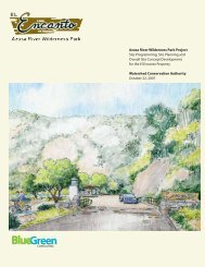
Item 13 - Watershed Conservation Authority
Item 13 - Watershed Conservation Authority
Item 13 - Watershed Conservation Authority

You also want an ePaper? Increase the reach of your titles
YUMPU automatically turns print PDFs into web optimized ePapers that Google loves.
<strong>Item</strong> <strong>13</strong><br />
DATE: July 18, 20<strong>13</strong><br />
TO:<br />
FROM:<br />
SUBJECT:<br />
WCA Governing Board<br />
Mark Stanley, Executive Officer<br />
<strong>Item</strong> <strong>13</strong>: Consideration of a resolution authorizing an amendment to<br />
the Memorandum of Understanding with the Los Angeles County<br />
Flood Control District for the Emerald Necklace Feasibility Study &<br />
Implementation Plan.<br />
RECOMMENDATION: Authorize the Executive Officer to enter into an amended<br />
Memorandum of Understanding (MOU) with the Los Angeles County Flood Control<br />
District that directs additional funding to the Emerald Necklace Feasibility Study &<br />
Implementation Plan.<br />
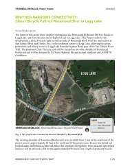
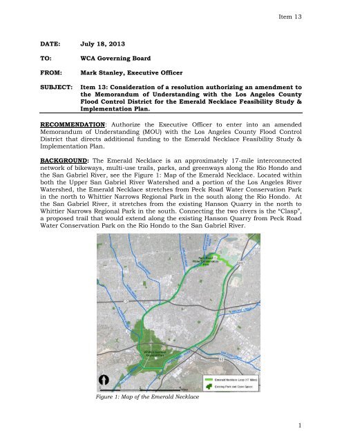
BACKGROUND: The Emerald Necklace is an approximately 17-mile interconnected<br />
network of bikeways, multi-use trails, parks, and greenways along the Rio Hondo and<br />
the San Gabriel River, see the Figure 1: Map of the Emerald Necklace. Located within<br />
both the Upper San Gabriel River <strong>Watershed</strong> and a portion of the Los Angeles River<br />
<strong>Watershed</strong>, the Emerald Necklace stretches from Peck Road Water <strong>Conservation</strong> Park<br />
in the north to Whittier Narrows Regional Park in the south along the Rio Hondo. At<br />
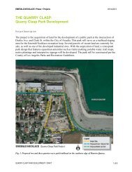
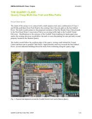
the San Gabriel River, it stretches from the existing Hanson Quarry in the north to<br />
Whittier Narrows Regional Park in the south. Connecting the two rivers is the “Clasp”,<br />
a proposed trail that would extend along the existing Hanson Quarry from Peck Road<br />
Water <strong>Conservation</strong> Park on the Rio Hondo to the San Gabriel River.<br />
Figure 1: Map of the Emerald Necklace<br />
1
<strong>Item</strong> <strong>13</strong><br />
In 2005, Amigos de los Ríos, a California non-profit organization, in conjunction with<br />
various cities and stakeholders, developed a Vision Plan for the Emerald Necklace.<br />
The Emerald Necklace Vision Plan contains 29 projects of which 16 are within or<br />
include the area under Los Angeles County Flood Control District (LACFCD) or Los<br />
Angeles County Department of Parks and Recreation (LACDPR) jurisdiction.<br />
Interconnecting these projects in the Vision Plan are opportunities for the development<br />
of trails and linear greenway projects along the Rio Hondo and the San Gabriel River.<br />
In 2006 a coordination committee was formed to facilitate projects and project<br />
development along the Emerald Necklace, this committee consists of a member from<br />
each of the following agencies and organizations: Amigos de los Rios, LACFCD,<br />
LACDPR, Los Angeles County Supervisorial District 1 staff, and the Rivers and<br />
Mountains Conservancy. In order to identify issues and create solutions to<br />
implementing the Vision Plan, this committee recognized the need to analyze the<br />
technical feasibility of projects that are proposed for property or facilities under<br />
LACFCD or LACDPR, and prioritize those projects based on public safety, community<br />
support and benefit, connectivity, as well as implementation and operation &<br />
maintenance costs. The extent of above listed planning activities were combined,<br />
resulting in the development of the scope of work for the Emerald Necklace Feasibility<br />
Study and Implementation Plan.<br />
To finance this planning project, the coordination committee raised funds from<br />
Southern California Edison as well as the LACFCD. A total of $500,000 was raised for<br />
the planning project with LACFCD providing $200,000 and Southern California Edison<br />
providing $300,000. The WCA was hire to manage the project and coordinate the work<br />
with the committee members. Subsequently, WCA contracted with a consultant team<br />
to provide technical services for the project. The purpose of the MOU agreement with<br />
LACFCD is to work closely with the staff as well as to fund a portion of the Emerald<br />
Necklace Feasibility Study and Implementation Plan. The MOU between LACFCD &<br />
WCA is attached as Exhibit A.<br />
Since the initiation of the Emerald Necklace Feasibility Study and Implementation<br />
Plan project in early 2011, the feasibility study portion identified 44 project that will<br />
enhance the Emerald Necklace, and improve multi-use trails and Class I bikeways.<br />
With input from the coordination committee, a sub-set of 16 projects have been<br />
prioritized, and represent an initial phase that is being further analysis within the<br />
ongoing development of the Implementation Plan, as well as a draft Program EIR.<br />
These 16 projects were further prioritized, with seven projects identified as high<br />
priority with input from community members and stakeholders. These high priority<br />
projects will lead to the development of the 'Clasp' and reduce traffic conflicts,<br />
primarily within the Whittier Narrows. High priority project are receiving further<br />
analysis within the Implementation Plan and Program EIR.<br />
Parallel to the development of the Implementation Plan, the County of Los Angeles<br />
Department of Public Works (DPW) also prepared and submitted a grant proposal to<br />
the Transportation Investment Generating Economic Recovery (TIGER) Program<br />
administered by the U.S. Department of Transportation. This grant proposal included<br />
one project not previously identified within the feasibility study, as well as the<br />
modification of two projects identified as high priority. Illustration of the proposed<br />
projects are included as Exhibit B.<br />
2
<strong>Item</strong> <strong>13</strong><br />
To ensure these projects can meet the Federal TIGER Grant Program implementation<br />
timeline requirements, the WCA and DPW staff proposes to incorporate the added<br />
projects into the WCA's current Implementation Plan and draft Program EIR planning<br />
work. Additionally, WCA and DPW staff is proposing to utilize the WCA's consultant<br />
contract with Withers & Sandgren for the planning task necessary to conduct NEPA<br />
analysis and documentation for the TIGER projects. This approach is intended to<br />
complete the CEQA and NEPA requirements for the TIGER projects in a compressed<br />
timeline. With approval from the Los Angeles County Board of Supervisors, the DPW<br />
has agreed to fund this added scope. As the administrators of the LACFCD, the DPW<br />
intends to direct these funds to the WCA through an amendment to the existing MOU<br />
with LACFCD.<br />
Fiscal Information: The Emerald Necklace Feasibility Study and Implementation<br />
Plan has two sources of funding: 1) LACFCD funds in the amount of $200,000, and 2)<br />
$300,000 in funding from Southern California Edison through the California<br />
Community Foundation (CCF). LACFCD funds are held by the WCA, while the WCA<br />
invoices CCF directly on a reimbursement basis.<br />
This action would increase the total contribution from the LACFCD by an amount<br />
currently being determined, that includes $40,500 for consultants efforts to<br />
incorporate the TIGER projects in the Implementation Plan and CEQA EIR process<br />
(Exhibit C) and a yet to be determined amount for the NEPA efforts. The total added<br />
funding from the LACFCD will include the actual cost of the professional services, plus<br />
15% for WCA project management and administration.<br />
3
Exhibit A <strong>Item</strong> <strong>13</strong><br />
4
Exhibit A <strong>Item</strong> <strong>13</strong><br />
5
Exhibit A <strong>Item</strong> <strong>13</strong><br />
6
Exhibit A <strong>Item</strong> <strong>13</strong><br />
7
BL<br />
GABRIEL<br />
BLVD<br />
ROSEMEAD<br />
BLVD<br />
TEMPLE<br />
AV<br />
S<br />
ANITA<br />
SANTA<br />
AV<br />
AV<br />
ANITA<br />
MYRTLE<br />
AV<br />
Exhibit B<br />
APPENDIX A-1. Project Map<br />
Pasadena<br />
BLVD<br />
Sierra Madre<br />
<strong>Item</strong> <strong>13</strong><br />
BLVD<br />
Monrovia<br />
Bradbury<br />
FRWY<br />
FOOTHILL<br />
W COLORADO PL<br />
BLVD<br />
AV<br />
BL<br />
E<br />
BLVD<br />
DUARTE<br />
RD<br />
ROSEMEAD<br />
Unincorporated<br />
TUNAS<br />
DUARTE<br />
SUNSET<br />
DR<br />
BLVD<br />
TEMPLE<br />
CITY<br />
RD<br />
BLVD<br />
BALDWIN<br />
HU N TINGTON<br />
AV<br />
DUARTE<br />
Arcadia<br />
LAS TUNAS<br />
Peck Road Water<br />
<strong>Conservation</strong> Park<br />
DR<br />
ARCADIA WASH<br />
Unincorp.<br />
SANTA ANITA WASH<br />
RD<br />
RD<br />
Unincorp.<br />
S<br />
AV<br />
MYRTLE<br />
FRWY<br />
SAWPIT WASH<br />
ARROW<br />
Irwindale<br />
PROJECT 1<br />
DR<br />
BUENA VISTA<br />
FRWY<br />
HWY<br />
SAN<br />
RIVER<br />
HUNTINGTON<br />
Duarte<br />
GABRIEL<br />
FRWY<br />
SAN<br />
ARROW<br />
BL<br />
GABRIEL<br />
RIVER<br />
FRWY<br />
SantaFeDam<br />
Recreation<br />
Area<br />
San Gabriel<br />
Temple City<br />
BLVD<br />
RIVER<br />
Quarry<br />
Clasp<br />
PARK<br />
SAN<br />
SAN<br />
ALHAMBRA WASH<br />
RUBIO WASH<br />
Rosemead<br />
BERNARDINO<br />
BLVD<br />
DR<br />
BLVD<br />
AV<br />
FRWY<br />
CITY<br />
VALLEY<br />
EATON WASH<br />
GARVEY<br />
BALDWIN<br />
BLVD<br />
RIO HONDO<br />
AV<br />
TYLER<br />
AV<br />
SAN<br />
SANTA<br />
El Monte<br />
RD<br />
PECK<br />
VALLEY<br />
RAMONA<br />
AV<br />
AV<br />
DURFEE<br />
§¨¦ 210 §¨¦ 10<br />
SAN GABRIEL RIVER<br />
SAN<br />
GABRIEL<br />
BERNARDINO<br />
BLVD<br />
FRWY<br />
WALNUT CREEK<br />
RAMONA<br />
BALDWIN<br />
BL<br />
Baldwin Park<br />
BIG DALTON WASH<br />
AV<br />
SAN<br />
PACIFIC<br />
PUENTE<br />
West Covina<br />
R<br />
IEL<br />
RUSH ST<br />
BL<br />
SAN<br />
BLVD<br />
PROJECT 3<br />
Montebello<br />
RIO HONDO<br />
BL<br />
GABRIEL<br />
Pico Rivera<br />
BLVD<br />
BLVD<br />
FRWY<br />
BLVD<br />
BLVD<br />
ROSEMEAD<br />
RIVER<br />
PROJECT 2<br />
Whittier Narrows<br />
Recreation Area<br />
Unincorporated<br />
Whittier<br />
Narrows<br />
FRWY<br />
D<br />
Legg<br />
Lake<br />
SAN<br />
POMONASANTA ANITA<br />
DURFEE<br />
G<br />
WORKMAN<br />
BEVERLY<br />
NORWALK<br />
South El Monte<br />
BLVD<br />
ABRIEL<br />
RIVER<br />
SAN GABRIEL RIVER<br />
MILL<br />
FRWY<br />
SAN<br />
RD<br />
RD<br />
TYLER<br />
PECK<br />
Unincorporated<br />
Whittier<br />
PECK<br />
WO RKMAN<br />
AV<br />
GABRIEL<br />
This map is for planning purposes only. Los Angeles<br />
County expressly disclaims any liability for any<br />
inaccuracies which may be present in this map.<br />
CANYON<br />
§¨¦ 605<br />
MILL<br />
RIVER<br />
FRWY<br />
BASSETT<br />
Unincorporated<br />
AVOCADO HEIGHTS<br />
SAN JOSE CREEK<br />
·|} 60<br />
FRWY<br />
AMAR<br />
RD<br />
RD<br />
RD<br />
0 0.5<br />
1<br />
Mile<br />
Data contained in this map is produced in whole<br />
or part from the Los Angeles County Department<br />
of Public Works' digital database.<br />
Legend<br />
PU ENTE<br />
BLVD<br />
AV<br />
PUENTE<br />
VALLEY<br />
Industry<br />
TURNBULL<br />
AMAR<br />
Emerald Necklace<br />
River / Major Channel<br />
Existing Class I Bike Path<br />
Existing Class II Bike Path<br />
La Puente<br />
Proposed Bike Path/Trail Connection<br />
Proposed Bike Path/Trail Bridge<br />
City Boundary<br />
I<br />
RD<br />
CANYON<br />
SUNSET<br />
PUENTE CREEK<br />
Key Connector Projects:<br />
1 TheQuarry Clasp / Peck Park Trails<br />
2 Rush Street / Rio Hondo Bike Trail Connector and Bridge<br />
3 The San Gabriel Blvd / Rio Hondo Bike Trail Connector<br />
TURNBULL<br />
CANYON<br />
RD<br />
POMONA<br />
BLVD<br />
BLVD<br />
8<br />
Data contained in this map is produced in whole or part from the<br />
Thomas Bros. Maps ®. This map is copyrighted, and reproduced with<br />
permission granted, by Thomas Bros. Maps ®. All rights reserved.<br />
HA CIEND<br />
VALLE<br />
PATH: \\pwgisfile\GIS_Services\MPMGIS\projects\mpm\wk_EmeraldNecklace\Tiger20<strong>13</strong>_Grant4.mxd DATE: 5/28/20<strong>13</strong><br />
Survey/Mapping & Property Management Division, Mapping & GIS Services Section
<strong>Item</strong> <strong>13</strong><br />
S 4TH AV<br />
Irwindale<br />
SAN GABRIEL RIVER<br />
LOWER AZUSA RD<br />
ELROVIA AV<br />
9<br />
DURFEE AV<br />
LIVE OAK AV<br />
S PECK RD<br />
SAWPIT WASH<br />
SANTA ANITA WASH<br />
Unincorporated<br />
Unincorporated<br />
Arcadia<br />
El Monte<br />
Monrovia<br />
CLARK ST<br />
GOLDRING RD<br />
RIO HONDO PWY<br />
LA MADERA AV<br />
COGSWELL RD<br />
HEMLOCK ST<br />
PECK RD<br />
BUFFINGTON RD<br />
E LIVE OAK AV<br />
LYND AV<br />
S 9TH AV<br />
HALLWOOD DR<br />
S 8TH AV<br />
Exhibit B<br />
LENORE AV<br />
FARNA AV<br />
CEDAR AV<br />
LOWER AZUSA RD<br />
RIO<br />
HONDO
Exhibit B<br />
APPENDIX A-4. Project 2 Detail<br />
<strong>Item</strong> <strong>13</strong><br />
Rosemead<br />
Unincorporated<br />
RIO HONDO CHANNEL<br />
Whittier Narrows Golf Course<br />
CLUBHOUSE<br />
RUSH ST<br />
Legend<br />
Existing Class I Bike Path<br />
Proposed Bike Path/Trail Connection<br />
Proposed Bike Path/Trail Bridge<br />
Proposed Golf Cart Bridge<br />
City Boundary<br />
I<br />
0 150 300<br />
10<br />
Feet<br />
PATH: \\pwgisfile\GIS_Services\MPMGIS\projects\mpm\wk_EmeraldNecklace\Tiger20<strong>13</strong>_Grant_Proj2rev.mxd DATE: 5/28/20<strong>13</strong> This map is for planning purposes only
Exhibit B<br />
APPENDIX A-5. Project 3 Detail<br />
PLAZA DR<br />
<strong>Item</strong> <strong>13</strong><br />
Whittier Narrows Recreation Area<br />
Proposed Class I Bike Path<br />
Bridge Underpass<br />
See A-5.2<br />
·|} 19<br />
Montebello<br />
Legend<br />
Existing Class I Bike Path<br />
Proposed Bike Path/Trail Connection<br />
Proposed Park-and-Ride Lot<br />
N LINCOLN AV<br />
SAN GABRIEL BLVD<br />
RIO HONDO<br />
Proposed Class I Bike Path<br />
with Barrier. See A-5.1<br />
Install Barrier and Enhance<br />
Existing Bike Path<br />
ROSEMEAD BLVD<br />
DURFEE<br />
AV<br />
SIP H O N RD<br />
Intersection Improvements<br />
City Boundary<br />
Unincorporated<br />
I<br />
0 200 400<br />
11<br />
Feet<br />
PATH: \\pwgisfile\GIS_Services\MPMGIS\projects\mpm\wk_EmeraldNeck lace\Tiger20<strong>13</strong>_Grant_Proj3rev2.mxd DATE: 5/28/20<strong>13</strong> This map is for planning purposes only
Exhibit C <strong>Item</strong> <strong>13</strong><br />
STAFFING AND FEE SCHEDULE - Emerald Necklace: Feasibility, Implementation Plan, and Programmatic EIR/EIS Additional Services for TIGER<br />
Project Inclusion<br />
Fee Estimates (6/14/20<strong>13</strong>)<br />
Withers & Sandgren -- BlueGreen Consulting<br />
Urban Assessment<br />
CWE ECORP<br />
Planners<br />
Urban Crossroads<br />
Environmental<br />
Hours<br />
TOTALS<br />
Jan Sandgren<br />
Principal Planner<br />
Lynne Dwyer<br />
Principal<br />
Martin Kammerer<br />
Principal<br />
Lacey Withers<br />
Principal<br />
Landscape Architect<br />
Patty Nalle<br />
Landscape Architect<br />
Landscape Designer<br />
Desiree Harbaugh<br />
Bryan Matsumoto<br />
Landscape Designer<br />
Vik Bapna Principal<br />
Engineer<br />
Project Engineer<br />
Labor Rate ($/hr) 150 150 150 150 110 110 85 154 101 125 N/A 145 90 165 100 165 100 90 75 110 145 140 108<br />
Carrie Sutkin<br />
DPDS<br />
PART A: (SUB to ECORP) $ 1,800<br />
DEFINING STAKEHOLDERS OBJECTIVES<br />
Assistant<br />
Anne Surdzial<br />
CEQA/NEPA Task<br />
Manager<br />
Associate<br />
Environmental Analyst<br />
Mari Quillman<br />
Principal Biologist<br />
Staff Biologist<br />
Roger Mason Principal<br />
Cultural Resources<br />
Specialist<br />
Staff Cultural<br />
Resources Specialist<br />
Contracts<br />
Clerical<br />
GIS<br />
Carlton Waters<br />
Traffic Engineer<br />
Aric Evatt<br />
Air Quality Specialist<br />
Bill Lawson<br />
Accoustical Engineer<br />
1.1 Kickoff Meetings<br />
1.2 Field Investigations 2<br />
1.3 Data Compilation and Review 1 6<br />
2.1 Identify and Document Project Team Agency Objectives<br />
2.2 Identify Additional Stakeholders 2<br />
2.3 Community Meetings and Agency Stakeholder Meeting<br />
3. Synthesis of All Project Objectives 1<br />
PART B $ 14,175<br />
FEASIBILITY STUDY<br />
4.1 Evaluate Feasibility of Projects 3<br />
4.2 Evaluate Environmental Impacts 8 40 1 6 8 8 4<br />
4.3 Agency and Stakeholder Meetings<br />
4.4 Benefit Cost Ratios<br />
4.5 Summary of Implementation Challenges (Report) 8 8 30<br />
4.6 Evaluate Connectivity and Develop Multi-Use Trails<br />
4.7 Evaluate the Feasibility of Linear Greenways and Projects<br />
PART C $ 21,360<br />
IMPLEMENTATION PLAN AND PROGRAMATIC EIR/EIS<br />
0<br />
2<br />
7<br />
0<br />
2<br />
0<br />
1<br />
3<br />
75<br />
0<br />
0<br />
46<br />
0<br />
0<br />
5.1 Develop an Implementation Plan (Report) 8 15<br />
5.2 Prepare Remaining Elements for a Programmatic EIR/EIS 4 1 3 1<br />
5.3 Develop Draft Programmatic EIR/EIS 32 56 2 4 4 21 12<br />
5.4 Administrative Final Programmatic EIR/EIS and Notices 8 12 1 1 1 4 2<br />
23<br />
9<br />
<strong>13</strong>1<br />
29<br />
PART D<br />
ALTERNATIVES FOR THE "CLASP"<br />
6.1 Develop Feasible Multi-Use Trail Alternative(s) for the Clasp<br />
PART E $ -<br />
SIGNAGE PLAN FOR THE EMERALD NECKLACE<br />
7.1 Signage Plan<br />
0<br />
Labor Total Fee $ 37,335<br />
Labor Total Hours 20 0 42 0 30 0 0 0 0 44 68 4 45 1 11 0 36 23 4 0 0<br />
Direct Cost/Expenses $ 1,800<br />
Mark-Up on Sub Consultants - Approx. 5% $ 1,237<br />
Grand Total: $ 40,372<br />
0<br />
12
<strong>Item</strong> <strong>13</strong><br />
July 18, 20<strong>13</strong> – <strong>Item</strong> <strong>13</strong><br />
RESOLUTION 20<strong>13</strong>-23<br />
CONSIDERATION OF A RESOLUTION AUTHORIZING AN<br />
AMENDMENT TO THE MEMORANDUM OF<br />
UNDERSTANDING WITH THE LOS ANGELES COUNTY<br />
FLOOD CONTROL DISTRICT FOR THE EMERALD<br />
NECKLACE FEASIBILITY STUDY & IMPLEMENTATION<br />
PLAN<br />
WHEREAS, the <strong>Watershed</strong> <strong>Conservation</strong> <strong>Authority</strong> (WCA) has been established to<br />
facilitate joint projects between the Rivers and Mountains Conservancy and Los<br />
Angeles County Flood Control District; and<br />
WHEREAS, The <strong>Watershed</strong> <strong>Conservation</strong> <strong>Authority</strong> has been established to focus on<br />
projects which will provide open space, habitat restoration, and watershed<br />
improvement projects in both the San Gabriel and Lower Los Angeles Rivers<br />
watershed; and<br />
WHEREAS, this action authorizes the Executive Officer to enter into an amended<br />
Memorandum of Understanding with the Los Angeles County Flood Control District for<br />
the Emerald Necklace Feasibility Study & Implementation Plan; and<br />
WHEREAS, this action is exempt from the environmental impact report requirements<br />
of the California Environmental Quality Act (CEQA).<br />
Therefore be it resolved that the WCA hereby:<br />
1. FINDS that this action is consistent with the purposes and objectives of the<br />
WCA.<br />
2. FINDS that the actions contemplated by this resolution are exempt from the<br />
environmental impact report requirements of the California Environmental<br />
Quality Act.<br />
3. ADOPTS the staff report dated July 18, 20<strong>13</strong>.<br />
4. AUTHORIZES the Executive Officer to enter into an amended Memorandum of<br />
Understanding with the Los Angeles County Flood Control District that directs<br />
additional funding to the Emerald Necklace Feasibility Study & Implementation<br />
Plan.<br />
~ End of Resolution ~<br />
//<br />
<strong>13</strong>
Resolution 20<strong>13</strong>-23<br />
<strong>Item</strong> <strong>13</strong><br />
Motion: _______________________ Second: _______________________<br />
Ayes: _________<br />
Nays: ____________ Abstentions: _____________<br />
Passed and Adopted by the Board of the<br />
WATERSHED CONSERVATION AUTHORITY<br />
On July 18, 20<strong>13</strong><br />
_________________________________<br />
Teresa Villegas, Chairperson<br />
ATTEST:<br />
______________________<br />
Terry Fujimoto<br />
Deputy Attorney General<br />
14