Rising Tree Wind Farm Project Notice of Preparation - County of Kern
Rising Tree Wind Farm Project Notice of Preparation - County of Kern
Rising Tree Wind Farm Project Notice of Preparation - County of Kern
Create successful ePaper yourself
Turn your PDF publications into a flip-book with our unique Google optimized e-Paper software.
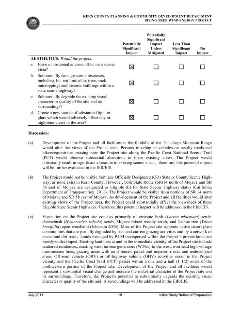
AESTHETICS. Would the project:<br />
a. Have a substantial adverse effect on a scenic<br />
vista?<br />
b. Substantially damage scenic resources,<br />
including, but not limited to, trees, rock<br />
outcroppings and historic buildings within a<br />
state scenic highway?<br />
c. Substantially degrade the existing visual<br />
character or quality <strong>of</strong> the site and its<br />
surroundings?<br />
d. Create a new source <strong>of</strong> substantial light or<br />
glare which would adversely affect day or<br />
nighttime views in the area?<br />
Discussion:<br />
KERN COUNTY PLANNING & COMMUNITY DEVELOPMENT DEPARTMENT<br />
RISING TREE WIND ENERGY PROJECT<br />
Potentially<br />
Significant<br />
Impact<br />
Potentially<br />
Significant<br />
Impact<br />
Unless<br />
Mitigated<br />
Less Than<br />
Significant<br />
Impact<br />
No<br />
Impact<br />
(a) Development <strong>of</strong> the <strong>Project</strong> and all facilities in the foothills <strong>of</strong> the Tehachapi Mountain Range<br />
would alter the views <strong>of</strong> the <strong>Project</strong> area. Persons traveling in vehicles on nearby roads and<br />
hikers/equestrians passing near the <strong>Project</strong> site along the Pacific Crest National Scenic Trail<br />
(PCT) would observe substantial alterations to these existing views. The <strong>Project</strong> would<br />
potentially result in significant alteration to existing scenic vistas; therefore, this potential impact<br />
will be further evaluated in the EIR/EIS.<br />
(b) The <strong>Project</strong> would not be visible from any Officially Designated (OD) State or <strong>County</strong> Scenic Highway,<br />
as none exist in <strong>Kern</strong> <strong>County</strong>. However, both State Route (SR)14 north <strong>of</strong> Mojave and SR<br />
58 east <strong>of</strong> Mojave are designated as Eligible (E) for State Scenic Highway status (California<br />
Department <strong>of</strong> Transportation, 2011). The <strong>Project</strong> would be visible from portions <strong>of</strong> SR 14 north<br />
<strong>of</strong> Mojave and SR 58 east <strong>of</strong> Mojave. As development <strong>of</strong> the <strong>Project</strong> and all facilities would alter<br />
existing views <strong>of</strong> the <strong>Project</strong> area, the <strong>Project</strong> could substantially affect the viewsheds <strong>of</strong> these<br />
Eligible State Scenic Highways. Therefore, this potential impact will be addressed in the EIR/EIS.<br />
(c) Vegetation on the <strong>Project</strong> site consists primarily <strong>of</strong> creosote bush (Larrea tridentata) scrub,<br />
cheesebush (Hymenoclea salsola) scrub, Mojave mixed woody scrub, and Joshua tree (Yucca<br />
brevifolia) open woodland (Johnston 2006). Most <strong>of</strong> the <strong>Project</strong> site supports native desert plant<br />
communities that are partially degraded by past and current grazing activities and by a network <strong>of</strong><br />
paved and dirt roads. Lands managed by BLM interspersed within the <strong>Project</strong>’s private lands are<br />
mostly undeveloped. Existing land uses at and in the immediate vicinity <strong>of</strong> the <strong>Project</strong> site include<br />
scattered residences, existing wind turbine generators (WTGs) to the west, overhead high-voltage<br />
transmission lines, grazing areas with rural fences, paved and unpaved roads, and undeveloped<br />
areas. Off-road vehicle (ORV) or <strong>of</strong>f-highway vehicle (OHV) activities occur in the <strong>Project</strong><br />
vicinity and the Pacific Crest Trail (PCT) passes within a one and a half (1 1/2) miles <strong>of</strong> the<br />
northwestern portion <strong>of</strong> the <strong>Project</strong> site. Development <strong>of</strong> the <strong>Project</strong> and all facilities would<br />
represent a substantial visual change and increase the industrial character <strong>of</strong> the <strong>Project</strong> site and<br />
its surroundings. Therefore, the <strong>Project</strong>’s potential to substantially degrade the existing visual<br />
character or quality <strong>of</strong> the site and its surroundings will be addressed in the EIR/EIS.<br />
July 2011 19 Initial Study/<strong>Notice</strong> <strong>of</strong> <strong>Preparation</strong>


