Policies to Reduce Emissions from Deforestation and Degradation ...
Policies to Reduce Emissions from Deforestation and Degradation ...
Policies to Reduce Emissions from Deforestation and Degradation ...

Create successful ePaper yourself
Turn your PDF publications into a flip-book with our unique Google optimized e-Paper software.
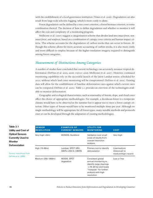
Table 3.1<br />
Utility <strong>and</strong> Cost of<br />
Optical Sensors<br />
Currently Used <strong>to</strong><br />
Moni<strong>to</strong>r<br />
<strong>Deforestation</strong><br />
Source: reproduced <strong>from</strong><br />
DeFries et al. (2006)<br />
with the establishment of a local governance institution (Trines et al. 2006). <strong>Degradation</strong> can also<br />
result <strong>from</strong> large-scale selective logging, which is more costly <strong>to</strong> abate.<br />
Forest degradation can be defined by a tree cover criterion, a forest biomass criterion, or some<br />
combination thereof. The decision of how <strong>to</strong> define degradation <strong>and</strong> whether <strong>to</strong> moni<strong>to</strong>r it will<br />
affect the cost <strong>and</strong> complexity of a moni<strong>to</strong>ring program.<br />
Mollicone et al. (2007) suggest a categorization scheme that divides l<strong>and</strong> in<strong>to</strong> intact forest, nonintact<br />
forest, <strong>and</strong> nonforest, based on a combination of canopy cover criteria <strong>and</strong> human impact criteria.<br />
This scheme accounts for the degradation of carbon s<strong>to</strong>cks that can occur in forests. Although<br />
this scheme allows for more accurate accounting of carbon s<strong>to</strong>cks, it is also more costly<br />
<strong>and</strong> more difficult <strong>to</strong> employ because of the higher-resolution imagery required <strong>to</strong> distinguish<br />
among forest categories.<br />
Measurement of Distinctions Among Categories<br />
A number of studies have concluded that current technology can accurately measure tropical deforestation<br />
(DeFries et al. 2005, 2006; UNFCCC 2006; Mollicone et al. 2007). However, continued<br />
moni<strong>to</strong>ring capabilities rely on the successful launch of the latest L<strong>and</strong>sat sensor, scheduled for<br />
2010, without which l<strong>and</strong> cover moni<strong>to</strong>ring will be compromised (DeFries et al. 2005). Existing<br />
data will allow for the establishment of baseline deforestation rates against which current rates<br />
can be compared (DeFries et al. 2005). Table 3.1 provides an overview of the technologies available<br />
<strong>to</strong> moni<strong>to</strong>r deforestation.<br />
Geographic <strong>and</strong> ecological characteristics, such as seasonality of forests, slope, <strong>and</strong> cloud cover<br />
affect the choice of appropriate methodologies. For example, a deciduous forest in a temperate<br />
climate would have <strong>to</strong> be observed in the summer lest it appear not <strong>to</strong> meet a forest canopy criterion.<br />
Other types of forests would have <strong>to</strong> be moni<strong>to</strong>red multiple times per year. Although no<br />
single methodology will be appropriate for all forest types, many suitable methods <strong>and</strong> pro<strong>to</strong>cols<br />
exist or can be developed through the adaptation of existing methodologies.<br />
SENSOR EXAMPLES OF UTILITY FOR<br />
RESOLUTION CURRENT SENSORS MONITORING COST<br />
Very high (10–20 ha) <strong>and</strong> locate<br />
“hotspots” for further<br />
analysis with high<br />
resolution<br />
3 <strong>Policies</strong> <strong>to</strong> <strong>Reduce</strong> <strong>Emissions</strong> <strong>from</strong> <strong>Deforestation</strong> <strong>and</strong> <strong>Degradation</strong> in Developing Countries