Policies to Reduce Emissions from Deforestation and Degradation ...
Policies to Reduce Emissions from Deforestation and Degradation ...
Policies to Reduce Emissions from Deforestation and Degradation ...

You also want an ePaper? Increase the reach of your titles
YUMPU automatically turns print PDFs into web optimized ePapers that Google loves.
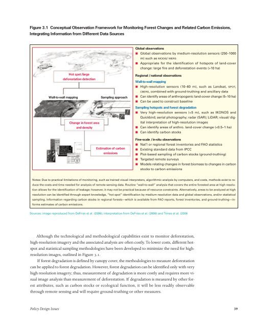
Figure 3.1 Conceptual Observation Framework for Moni<strong>to</strong>ring Forest Changes <strong>and</strong> Related Carbon <strong>Emissions</strong>,<br />
Integrating Information <strong>from</strong> Different Data Sources<br />
Hot spot/large<br />
deforestation detection<br />
Wall-<strong>to</strong>-wall mapping Sampling approach<br />
Change in forest area<br />
<strong>and</strong> density<br />
Estimation of carbon<br />
emissions<br />
Global observations<br />
ı Global observations by medium-resolution sensors (250–1000<br />
m) such as MODIS/ MERS<br />
ı Appropriate for the identification of hotspots of l<strong>and</strong>-cover<br />
change: large fire <strong>and</strong> deforestation events (>10 ha)<br />
Regional /national observations<br />
Wall-<strong>to</strong>-wall mapping<br />
ı High-resolution sensors (10–60 m), such as L<strong>and</strong>sat, SPOT,<br />
CBERS, combined with ground-truthing <strong>and</strong> ancillary data<br />
ı Can identify areas of anthropogenic l<strong>and</strong>-cover change (5–10 ha)<br />
ı Can be used <strong>to</strong> construct baseline<br />
Sampling hotspots <strong>and</strong> forest degradation<br />
ı Very high-resolution sensors (