TWENTIETH CENTURY DEFENCE SITES of TYNE and WEAR
TWENTIETH CENTURY DEFENCE SITES of TYNE and WEAR
TWENTIETH CENTURY DEFENCE SITES of TYNE and WEAR

Create successful ePaper yourself
Turn your PDF publications into a flip-book with our unique Google optimized e-Paper software.
Section 3 The Second World War<br />
Type B shelter could be converted into a<br />
cycle shed. A similar plan shows eight<br />
proposed shelters at Heaton School, which<br />
could accommodate 60 children (Ripley <strong>and</strong><br />
Pears 1994-2006, Mauchlen <strong>and</strong> Weightman<br />
April 1940, Pendower Elementary <strong>and</strong><br />
Central Schools, Newcastle – Proposed Air<br />
Raid Shelters for 720 children, NRO 4720/B/<br />
256, Northumberl<strong>and</strong> Record Office).<br />
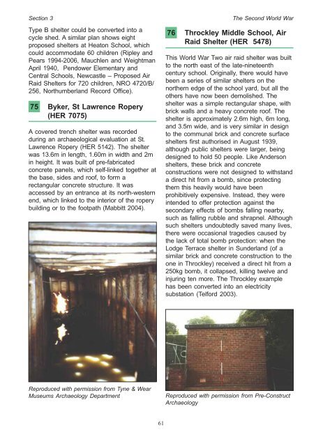
75 Byker, St Lawrence Ropery<br />
(HER 7075)<br />
A covered trench shelter was recorded<br />
during an archaeological evaluation at St.<br />
Lawrence Ropery (HER 5142). The shelter<br />
was 13.6m in length, 1.60m in width <strong>and</strong> 2m<br />
in height. It was built <strong>of</strong> pre-fabricated<br />
concrete panels, which self-linked together at<br />
the base, sides <strong>and</strong> ro<strong>of</strong>, to form a<br />
rectangular concrete structure. It was<br />
accessed by an entrance at its north-western<br />
end, which linked to the interior <strong>of</strong> the ropery<br />
building or to the footpath (Mabbitt 2004).<br />
Reproduced with permission from Tyne & Wear<br />
Museums Archaeology Department<br />
61<br />
76 Throckley Middle School, Air<br />
Raid Shelter (HER 5478)<br />
This World War Two air raid shelter was built<br />
to the north east <strong>of</strong> the late-nineteenth<br />
century school. Originally, there would have<br />
been a series <strong>of</strong> similar shelters on the<br />
northern edge <strong>of</strong> the school yard, but all the<br />
others have now been demolished. The<br />
shelter was a simple rectangular shape, with<br />
brick walls <strong>and</strong> a heavy concrete ro<strong>of</strong>. The<br />
shelter is approximately 2.6m high, 6m long,<br />
<strong>and</strong> 3.5m wide, <strong>and</strong> is very similar in design<br />
to the communal brick <strong>and</strong> concrete surface<br />
shelters first authorised in August 1939,<br />
although public shelters were larger, being<br />
designed to hold 50 people. Like Anderson<br />
shelters, these brick <strong>and</strong> concrete<br />
constructions were not designed to withst<strong>and</strong><br />
a direct hit from a bomb, since protecting<br />
them this heavily would have been<br />
prohibitively expensive. Instead, they were<br />
intended to <strong>of</strong>fer protection against the<br />
secondary effects <strong>of</strong> bombs falling nearby,<br />
such as falling rubble <strong>and</strong> shrapnel. Although<br />
such shelters undoubtedly saved many lives,<br />
there were occasional tragedies caused by<br />
the lack <strong>of</strong> total bomb protection: when the<br />
Lodge Terrace shelter in Sunderl<strong>and</strong> (<strong>of</strong> a<br />
similar brick <strong>and</strong> concrete construction to the<br />
one in Throckley) received a direct hit from a<br />
250kg bomb, it collapsed, killing twelve <strong>and</strong><br />
injuring ten more. The Throckley example<br />
has been converted into an electricity<br />
substation (Telford 2003).<br />
Reproduced with permission from Pre-Construct<br />
Archaeology