Smooth Bottom Net Trawl Fishing Gear Effect on - New England ...
Smooth Bottom Net Trawl Fishing Gear Effect on - New England ...
Smooth Bottom Net Trawl Fishing Gear Effect on - New England ...

Create successful ePaper yourself
Turn your PDF publications into a flip-book with our unique Google optimized e-Paper software.
NOAA/NMFS Unallied Science Project, Cooperative Agreement NA16FL2264 May 2005<br />
<str<strong>on</strong>g>Smooth</str<strong>on</strong>g> <str<strong>on</strong>g>Bottom</str<strong>on</strong>g> <str<strong>on</strong>g>Net</str<strong>on</strong>g> <str<strong>on</strong>g>Trawl</str<strong>on</strong>g> <str<strong>on</strong>g>Fishing</str<strong>on</strong>g> <str<strong>on</strong>g>Gear</str<strong>on</strong>g> <str<strong>on</strong>g>Effect</str<strong>on</strong>g> <strong>on</strong> the Seabed:<br />
Investigati<strong>on</strong> of Temporal and Cumulative <str<strong>on</strong>g>Effect</str<strong>on</strong>g>s BKAM/CR<br />
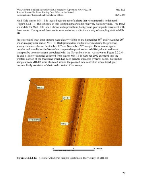
Mud Hole stati<strong>on</strong> MH-1B is located near the toe of a slope that rises gradually to the north<br />
(Figure 3.2.1-1). The substrate at this locati<strong>on</strong> appears to be relatively flat sandy mud. Pre-trawl<br />
s<strong>on</strong>ar<br />
data for Mud Hole lane 1 shows widespread faint background gear impacts c<strong>on</strong>sistent with<br />
door<br />
marks. Background door marks were not observed in the vicinity of sampling stati<strong>on</strong> MH-<br />
1B.<br />
Project-related trawl gear impacts were clearly visible <strong>on</strong> the September 30<br />
-<br />
pacted by trawl doors. November<br />
amples from MH-1B were clustered around the planned lane centerline where trawl gear<br />
pacts likely c<strong>on</strong>sisted of chain and cookies of the sweep.<br />
th and November 20<br />
s<strong>on</strong>ar imagery near stati<strong>on</strong> MH-1B. Background door marks observed during the pre-trawl<br />
survey remain visible <strong>on</strong> September 30 th and November 20 th images. These scours appear<br />
broader and less distinct in November compared to previous records likely due to sediment<br />
transport by bottom currents associated with the November storm. As shown <strong>on</strong> Figure 3.2.2.4<br />
1a and b (below) samples collected from stati<strong>on</strong> MH-1B in October 2002 extended into the<br />
western porti<strong>on</strong> of the trawl lane which had been directly im<br />
s<br />
im<br />
Figure 3.2.2.4-1a October 2002 grab sample locati<strong>on</strong>s in the vicinity of MH-1B<br />
th<br />
28