Smooth Bottom Net Trawl Fishing Gear Effect on - New England ...
Smooth Bottom Net Trawl Fishing Gear Effect on - New England ...
Smooth Bottom Net Trawl Fishing Gear Effect on - New England ...

You also want an ePaper? Increase the reach of your titles
YUMPU automatically turns print PDFs into web optimized ePapers that Google loves.
NOAA/NMFS Unallied Science Project, Cooperative Agreement NA16FL2264 May 2005<br />
<str<strong>on</strong>g>Smooth</str<strong>on</strong>g> <str<strong>on</strong>g>Bottom</str<strong>on</strong>g> <str<strong>on</strong>g>Net</str<strong>on</strong>g> <str<strong>on</strong>g>Trawl</str<strong>on</strong>g> <str<strong>on</strong>g>Fishing</str<strong>on</strong>g> <str<strong>on</strong>g>Gear</str<strong>on</strong>g> <str<strong>on</strong>g>Effect</str<strong>on</strong>g> <strong>on</strong> the Seabed:<br />
Investigati<strong>on</strong> of Temporal and Cumulative <str<strong>on</strong>g>Effect</str<strong>on</strong>g>s BKAM/CR<br />
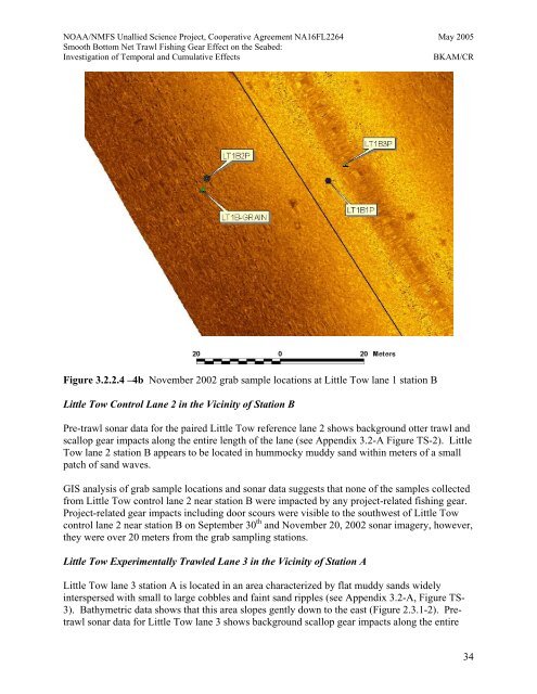
Figure 3.2.2.4 –4b November 2002 grab sample locati<strong>on</strong>s at Little Tow lane 1 stati<strong>on</strong> B<br />
Little Tow C<strong>on</strong>trol Lane 2 in the Vicinity of Stati<strong>on</strong> B<br />
Pre-trawl s<strong>on</strong>ar data for the paired Little Tow reference lane 2 shows background otter trawl and<br />
scallop gear impacts al<strong>on</strong>g the entire length of the lane (see Appendix 3.2-A Figure TS-2). Little<br />
Tow lane 2 stati<strong>on</strong> B appears to be located in hummocky muddy sand within meters of a small<br />
patch of sand waves.<br />
GIS analysis of grab sample locati<strong>on</strong>s and s<strong>on</strong>ar data suggests that n<strong>on</strong>e of the samples collected<br />
from Little Tow c<strong>on</strong>trol lane 2 near stati<strong>on</strong> B were impacted by any project-related fishing gear.<br />
Project-related gear impacts including door scours were visible to the southwest of Little Tow<br />
c<strong>on</strong>trol lane 2 near stati<strong>on</strong> B <strong>on</strong> September 30 th and November 20, 2002 s<strong>on</strong>ar imagery, however,<br />
they were over 20 meters from the grab sampling stati<strong>on</strong>s.<br />
Little Tow Experimentally <str<strong>on</strong>g>Trawl</str<strong>on</strong>g>ed Lane 3 in the Vicinity of Stati<strong>on</strong> A<br />
Little Tow lane 3 stati<strong>on</strong> A is located in an area characterized by flat muddy sands widely<br />
interspersed with small to large cobbles and faint sand ripples (see Appendix 3.2-A, Figure TS-<br />
3). Bathymetric data shows that this area slopes gently down to the east (Figure 2.3.1-2). Pretrawl<br />
s<strong>on</strong>ar data for Little Tow lane 3 shows background scallop gear impacts al<strong>on</strong>g the entire<br />
34