- Page 1 and 2:
DoD FLIGHT INFORMATION PUBLICATION
- Page 3 and 4:
INTRODUCTION GENERAL - AP/1B provid
- Page 5 and 6:
Chapter 1 IFR MILITARY TRAINING ROU
- Page 7 and 8:
VI. Aircraft Separation. A. To the
- Page 9 and 10:
(3) Contact Seymour Johnson APP CON
- Page 11 and 12:
(7) Alternate Exit AB shall be file
- Page 13 and 14:
100 MSL to I ODF 247/2 N34°41.00'
- Page 15 and 16:
05 AGL B 40 MSL to F MVC 131/21 N31
- Page 17 and 18:
DSN 965-4804. After hours 20 FW/Com
- Page 19 and 20:
IR-037 ORIGINATING ACTIVITY: FACSFA
- Page 21 and 22:
(4) Alternate Entry: B from west of
- Page 23 and 24:
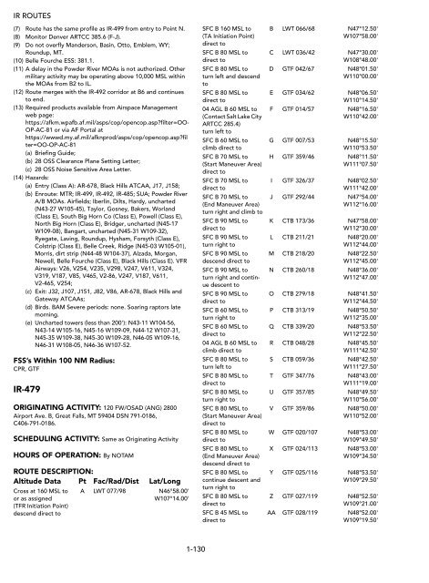
ROUTE DESCRIPTION: Altitude Data Pt
- Page 25 and 26:
ROUTE DESCRIPTION: Altitude Data Pt
- Page 27 and 28:
(b) Contact Atlanta ARTCC 120.55 27
- Page 29 and 30:
01 AGL B 40 MSL to H CBM 355/45 N34
- Page 31 and 32:
(b) Contact the different Schedulin
- Page 33 and 34:
(2) Advise controller when making t
- Page 35 and 36:
01 AGL B 40 MSL to C GQO 139/35 N34
- Page 37 and 38:
SCHEDULING ACTIVITY: 49 OSS/OSOS, 7
- Page 39 and 40:
IR-107 ORIGINATING ACTIVITY: 27 SOS
- Page 41 and 42:
01 AGL B 70 MSL to to R-5104/R-5105
- Page 43 and 44:
time enter at an Alternate Entry so
- Page 45 and 46:
01 AGL B 70 MSL to then via IR-113
- Page 47 and 48:
ight of centerline from E to F; 2 N
- Page 49 and 50:
(2) Minimum separation between sche
- Page 51 and 52:
90 MSL to Turn left and climb to cr
- Page 53 and 54:
ROUTE DESCRIPTION: Altitude Data Pt
- Page 55 and 56:
06 AGL B 30 MSL to (Alternate Entry
- Page 57 and 58:
(3) Contact Cherokee Control 294.6
- Page 59 and 60:
30 MSL B 90 MSL to C NQI 216/61 N26
- Page 61 and 62:
(10) Units requesting IR-139 shall
- Page 63 and 64:
ROUTE DESCRIPTION: Altitude Data Pt
- Page 65 and 66:
05 AGL B 30 MSL to E DLF 082/30 N29
- Page 67 and 68:
70 MSL to P LBB 042/38 N34°05.00'
- Page 69 and 70:
(11) Scheduling of, or amendments t
- Page 71 and 72:
SFC B 30 MSL to E RSG 153/24 N29°3
- Page 73 and 74:
ROUTE DESCRIPTION: Altitude Data Pt
- Page 75 and 76:
Special Operating Procedures: (1) A
- Page 77 and 78:
04 AGL B 90 MSL to turn left to E H
- Page 79 and 80:
(10) Aircrews are responsible for v
- Page 81 and 82:
Special Operating Procedures: (1) L
- Page 83 and 84: 05 AGL B 40 MSL to E GAG 323/25 N36
- Page 85 and 86: (a) starting at N32-14.55 W103-56.9
- Page 87 and 88: (6) If scheduled into Centennial Ra
- Page 89 and 90: (16) Obstacles on route less than 1
- Page 91 and 92: (6) Prior coordination with NAS Fal
- Page 93 and 94: IR-213 ORIGINATING ACTIVITY: G-3, 3
- Page 95 and 96: (4) Avoid airports along route by 2
- Page 97 and 98: SCHEDULING ACTIVITY: Commander AFFT
- Page 99 and 100: (4) Alternate Entry F: Ensure adher
- Page 101 and 102: (10) Aircrews experiencing loss of
- Page 103 and 104: TERRAIN FOLLOWING OPERATIONS: IMC/V
- Page 105 and 106: HOURS OF OPERATION: By NOTAM ROUTE
- Page 107 and 108: SFC B 90 MSL to Thence to Nellis Ta
- Page 109 and 110: 01 AGL B 110 MSL to direct to 01 AG
- Page 111 and 112: ROUTE WIDTH - 8 NM left and 4 NM ri
- Page 113 and 114: 01 AGL B 85 MSL to climb to 140 MSL
- Page 115 and 116: 01 AGL B 120 MSL to K BOI 027/73 N4
- Page 117 and 118: (b) Denver ARTCC at Point U on 256.
- Page 119 and 120: (h) Davenport AFLD N47-39-15 W118-1
- Page 121 and 122: hours 0800-1700 local. Non-duty hou
- Page 123 and 124: etween Points G and H. All structur
- Page 125 and 126: ROUTE DESCRIPTION: Altitude Data Pt
- Page 127 and 128: 02 AGL B 53 MSL to K LTJ 103/40 N45
- Page 129 and 130: Special Operating Procedures: (1) T
- Page 131 and 132: 03 AGL B 80 MSL to B LAA 354/36 N38
- Page 133: 01 AGL B 130 MSL to turn left to 01
- Page 137 and 138: obstructions within the route width
- Page 139 and 140: HOURS OF OPERATION: Continuous ROUT
- Page 141 and 142: 02 AGL B 67 MSL to turn right to 02
- Page 143 and 144: (3) Route is separated from conflic
- Page 145 and 146: (3) IR-504A alternate transition in
- Page 147 and 148: 100 MSL to Alternate Entry: D 50 MS
- Page 149 and 150: TERRAIN FOLLOWING OPERATIONS: Autho
- Page 151 and 152: (7) Alternate Entry Point is C (may
- Page 153 and 154: (f) Kanapolis Dam North N38-37.6 W9
- Page 155 and 156: IR-605 ORIGINATING ACTIVITY: 148th
- Page 157 and 158: at or above 80 MSL 80 MSL B 170 MSL
- Page 159 and 160: TF/ Visual Contour Operations, airc
- Page 161 and 162: SCHEDULING ACTIVITY: 23 BS/DOS, 300
- Page 163 and 164: segment. Minimum altitudes above 20
- Page 165 and 166: SFC B 40 MSL to Contact Cold Lake T
- Page 167 and 168: ROUTE DESCRIPTION: 02 AGL B 50 MSL
- Page 169 and 170: FSS’s Within 100 NM Radius: AOO,
- Page 171 and 172: 50 MSL to or 60 MSL as assigned. Cl
- Page 173 and 174: Special Operating Procedures: (1) M
- Page 175 and 176: SFC B 60 MSL to F BKW 221/20 N37°3
- Page 177 and 178: 02 AGL B 50 MSL to direct to 10 AGL
- Page 179 and 180: 02 AGL B 30 MSL to direct to 02 AGL
- Page 181 and 182: SFC B 60 MSL to direct to 04 AGL B
- Page 183 and 184: 10 AGL B 40 MSL to (Start Maneuver
- Page 185 and 186:
oute design. The route is designate
- Page 187 and 188:
TERRAIN FOLLOWING OPERATIONS: Autho
- Page 189 and 190:
(5) LOWAT approved on route segment
- Page 191 and 192:
(3) Restricted operations in and ar
- Page 193 and 194:
TERRAIN FOLLOWING OPERATIONS: Autho
- Page 195 and 196:
IR-916 ORIGINATING ACTIVITY: 611 AO
- Page 197 and 198:
TERRAIN FOLLOWING OPERATIONS: Autho
- Page 199 and 200:
01 AGL B 110 MSL to BB BIG 219/20 N
- Page 201 and 202:
civilian VFR traffic in the Interio
- Page 203 and 204:
will be given when known. Though no
- Page 205 and 206:
FSS’s Within 100 NM Radius: FAI,
- Page 207 and 208:
(19) Route Entry/Exit: MPY2 (319.2/
- Page 209 and 210:
Chapter 2 VFR MILITARY TRAINING ROU
- Page 211 and 212:
VR-025 ORIGINATING ACTIVITY: GA ANG
- Page 213 and 214:
05 AGL B 105 MSL to C LVL 235/31 N3
- Page 215 and 216:
(c) CROSSING: IR-720 left to right
- Page 217 and 218:
TERRAIN FOLLOWING OPERATIONS: Autho
- Page 219 and 220:
01 AGL B 65 AGL to C CVI 296/29 N36
- Page 221 and 222:
(g) VR-043: Seymour Johnson AFB; (h
- Page 223 and 224:
SCHEDULING ACTIVITY: 4 OSS/OSOS, Se
- Page 225 and 226:
(5) Use CAUTION when exiting at Poi
- Page 227 and 228:
VR-094 ORIGINATING ACTIVITY: 1st Av
- Page 229 and 230:
(n) CROSSING: IR-719 right to left
- Page 231 and 232:
(e) 200' AGL (600' MSL) N33-28.7 W8
- Page 233 and 234:
VR-106 ORIGINATING ACTIVITY: 97 OSS
- Page 235 and 236:
(b) Lake Conchas Resorts (N35-22.1
- Page 237 and 238:
(12) Aircraft not scheduled into R-
- Page 239 and 240:
01 AGL B 50 MSL to D RSG 282/53 N30
- Page 241 and 242:
ROUTE WIDTH - 3 NM either side of c
- Page 243 and 244:
ROUTE DESCRIPTION: Altitude Data Pt
- Page 245 and 246:
extends from centerline to the rout
- Page 247 and 248:
(4) Units requesting VR-186 shall f
- Page 249 and 250:
ROUTE DESCRIPTION: Altitude Data Pt
- Page 251 and 252:
(7) The entire route is designated
- Page 253 and 254:
(6) Contact Altus APP CON 257.725 1
- Page 255 and 256:
(8) Between E and F, avoid the town
- Page 257 and 258:
(6) Scheduling this route does not
- Page 259 and 260:
03 AGL B 90 MSL to E IWA 035/30 N33
- Page 261 and 262:
ROUTE WIDTH - 5 NM either side of c
- Page 263 and 264:
(3) Contact Scheduling Activity for
- Page 265 and 266:
03 AGL B 15 AGL to C CIE 008/20 N32
- Page 267 and 268:
10 AGL B 15 AGL to G GBN 259/33 N32
- Page 269 and 270:
(8) CAUTION; Route coincides with o
- Page 271 and 272:
ROUTE DESCRIPTION: Altitude Data Pt
- Page 273 and 274:
(8) When practicable avoid by 1500'
- Page 275 and 276:
15 AGL B 40 MSL to F SLN 145/38 N38
- Page 277 and 278:
01 AGL B 06 AGL to (unless cleared
- Page 279 and 280:
ROUTE DESCRIPTION: Altitude Data Pt
- Page 281 and 282:
HOURS OF OPERATION: By NOTAM, 2 hr
- Page 283 and 284:
05 AGL B 30 MSL to D ICT 221/16 N37
- Page 285 and 286:
FSS’s Within 100 NM Radius: COU,
- Page 287 and 288:
(9) CAUTION: Low flying helicopters
- Page 289 and 290:
W76-31-30 to N40-28-00 W76-30-30 to
- Page 291 and 292:
HOURS OF OPERATION: Sunrise-Sunset
- Page 293 and 294:
01 AGL B 70 MSL to D YSC 134/46 N44
- Page 295 and 296:
HOURS OF OPERATION: Normal use 0800
- Page 297 and 298:
VR-936 ORIGINATING ACTIVITY: 611 AO
- Page 299 and 300:
ROUTE DESCRIPTION: Altitude Data Pt
- Page 301 and 302:
Range Control (ERC) on primary 229.
- Page 303 and 304:
01 AGL B 50 MSL to M FYU 095/73 N65
- Page 305 and 306:
(11) Segments J-M traverse Moody Tw
- Page 307 and 308:
(6) Between Points C-D, uncharted 8
- Page 309 and 310:
HOURS OF OPERATION: Continuous ROUT
- Page 311 and 312:
(d) VR-1050 crosses at Point A, bet
- Page 313 and 314:
(g) Salipta (Town) N31-38.0 W88-02.
- Page 315 and 316:
05 AGL B 15 AGL to J MEI 167/42 N31
- Page 317 and 318:
05 AGL B 15 AGL to D MEI 315/75 N33
- Page 319 and 320:
VR-1043 ORIGINATING ACTIVITY: CG MC
- Page 321 and 322:
VR-1051 ORIGINATING ACTIVITY: 14 OS
- Page 323 and 324:
(5) Avoid cities and towns by 1000'
- Page 325 and 326:
(9) CAUTION: VR-1059 transits Bulld
- Page 327 and 328:
HOURS OF OPERATION: 0700-0000 local
- Page 329 and 330:
VR-1077 ORIGINATING ACTIVITY: 156 A
- Page 331 and 332:
01 AGL B 15 AGL to F NRR 183/22 N17
- Page 333 and 334:
(4) Alternate Exit: E. (5) Avoid Br
- Page 335 and 336:
(8) CAUTION: Uncharted grass airstr
- Page 337 and 338:
01 AGL B 15 AGL to Alternate Entry:
- Page 339 and 340:
ROUTE DESCRIPTION: Altitude Data Pt
- Page 341 and 342:
VR-1110 ORIGINATING ACTIVITY: 301 O
- Page 343 and 344:
(4) Conflicts: (a) VR-1117 is the r
- Page 345 and 346:
HOURS OF OPERATION: 0600-2200 local
- Page 347 and 348:
FSS’s Within 100 NM Radius: FTW,
- Page 349 and 350:
(2) Route conflicts with several IR
- Page 351 and 352:
ROUTE DESCRIPTION: Altitude Data Pt
- Page 353 and 354:
TERRAIN FOLLOWING OPERATIONS: Autho
- Page 355 and 356:
ROUTE WIDTH - 2 NM either side of c
- Page 357 and 358:
Special Operating Procedures: (1) R
- Page 359 and 360:
W116-56.3; 300' Power lines South s
- Page 361 and 362:
Fallon airspace, maintain route, co
- Page 363 and 364:
HOURS OF OPERATION: Daylight hours,
- Page 365 and 366:
(d) 199' tower at Point K (N34-24-0
- Page 367 and 368:
02 AGL B 15 AGL to B PRB 219/21 N35
- Page 369 and 370:
(8) Alternate Entry: H and L. (9) A
- Page 371 and 372:
02 AGL B 15 AGL to I EED 075/31 N34
- Page 373 and 374:
FSS’s Within 100 NM Radius: BOI,
- Page 375 and 376:
SCHEDULING ACTIVITY: 124 WG/OSS (AN
- Page 377 and 378:
(5) Remain on centerline or left of
- Page 379 and 380:
(10) Cross Point F at 1500' AGL (51
- Page 381 and 382:
Special Operating Procedures: (1) R
- Page 383 and 384:
SCHEDULING ACTIVITY: Same as Origin
- Page 385 and 386:
01 AGL B 15 AGL to (Below 05 AGL on
- Page 387 and 388:
05 AGL B 15 AGL to E2 APN 274/37 N4
- Page 389 and 390:
03 AGL B 15 AGL to E FLM 244/15 N38
- Page 391 and 392:
TERRAIN FOLLOWING OPERATIONS: Autho
- Page 393 and 394:
05 AGL B 15 AGL to D BVT 259/18 N40
- Page 395 and 396:
VR-1647 ORIGINATING ACTIVITY: 127TH
- Page 397 and 398:
03 AGL B 15 AGL to F VOK 015/32 N44
- Page 399 and 400:
Special Operating Procedures: (1) C
- Page 401 and 402:
05 AGL B 15 AGL to E FKN 321/12 N36
- Page 403 and 404:
03 AGL B 15 AGL to F VXV 071/44 N36
- Page 405 and 406:
ROUTE DESCRIPTION: Altitude Data Pt
- Page 407 and 408:
(3) Contact Leesburg FSS prior to e
- Page 409 and 410:
01 AGL B 15 AGL to B MCG 211/20 N62
- Page 411 and 412:
SCHEDULING ACTIVITY: 3 OSS/OSOS, El
- Page 413 and 414:
5000' AGL, 15 May - 15 Jun and 15 N
- Page 415 and 416:
(23) Heavy migratory bird activity
- Page 417 and 418:
(15) Weather briefing support agenc
- Page 419 and 420:
Chapter 3 SLOW SPEED LOW ALTITUDE T
- Page 421 and 422:
SR-038 (COLUMBUS) ORIGINATING ACTIV
- Page 423 and 424:
SR-062 (NASHVILLE) BNA, BWG, PAH OR
- Page 425 and 426:
(4) Possible helicopter training pe
- Page 427 and 428:
(4) When not flying SR-102 in conju
- Page 429 and 430:
(Sontay Drop Zone). (Alternate Exit
- Page 431 and 432:
(9) Aircrews calling to schedule SR
- Page 433 and 434:
ROUTE DESCRIPTION: Altitude Data Pt
- Page 435 and 436:
at or above 02.5 AGL F N34°52.00'
- Page 437 and 438:
(b) Ranch 2 NM north and 1 NM east
- Page 439 and 440:
(b) BLACKJACK DROP ZONE: ROUTE WIDT
- Page 441 and 442:
SR-224 (LITTLE ROCK) LIT ORIGINATIN
- Page 443 and 444:
(Alternate Entry Point) ROUTE WIDTH
- Page 445 and 446:
(2) A right turn to 277 degrees mus
- Page 447 and 448:
HOURS OF OPERATION: Continuous ROUT
- Page 449 and 450:
(7) Traffic permitting, Dyess Tower
- Page 451 and 452:
at or above 03 AGL B N32°46.00' W9
- Page 453 and 454:
at or above 03 AGL D N32°45.00' W1
- Page 455 and 456:
(Alternate Entry Point) (Alternate
- Page 457 and 458:
(a) Request for weekend use shall b
- Page 459 and 460:
(d) SAN ANGELO TRANSITION: J3 N30°
- Page 461 and 462:
(Alternate Entry Point) (b) LLANO T
- Page 463 and 464:
G N30°52.50' W101°12.50' H N31°1
- Page 465 and 466:
ROUTE WIDTH - 5 NM either side of c
- Page 467 and 468:
HOURS OF OPERATION: Sunrise-Sunset
- Page 469 and 470:
SR-301 (MARYSVILLE) ILS, RNO ORIGIN
- Page 471 and 472:
ROUTE DESCRIPTION: Altitude Data Pt
- Page 473 and 474:
SR-488 (SEATTLE) SEA ORIGINATING AC
- Page 475 and 476:
SR-702 (DETROIT) DET, MBS ORIGINATI
- Page 477 and 478:
Remarks: Night Altitude data: As pe
- Page 479 and 480:
ROUTE WIDTH - 5 NM either side of c
- Page 481 and 482:
(2) For traffic de-confliction info
- Page 483 and 484:
at or above 05 AGL B N39°33.00' W7
- Page 485 and 486:
Remarks: (1) Entry Point: Andrews V
- Page 487 and 488:
SR-844 (MILLVILLE) MIV, SBY ORIGINA
- Page 489 and 490:
ROUTE WIDTH - 1 NM either side of c
- Page 491 and 492:
HOURS OF OPERATION: 1200-0400Z++ Da
- Page 493 and 494:
SCHEDULING ACTIVITY: 3 OSS/DOTS, DS
- Page 495 and 496:
(Stinson Drop Zone). ROUTE WIDTH -
- Page 497 and 498:
I. General. Chapter 4 REFUELING TRA
- Page 499 and 500:
4-3 AR ROUTES
- Page 501 and 502:
4-5 NUMBER ARIP ARCP AR4A (North) L
- Page 503 and 504:
4-7 NUMBER ARIP ARCP AR6 (North) SN
- Page 505 and 506:
4-9 NUMBER ARIP ARCP AR9 (East) GEG
- Page 507 and 508:
4-11 NUMBER ARIP ARCP AR11 (East) O
- Page 509 and 510:
4-13 NUMBER ARIP ARCP AR14 (East) O
- Page 511 and 512:
4-15 NUMBER ARIP ARCP AR62 (East) C
- Page 513 and 514:
4-17 NUMBER ARIP ARCP AR104M EIC VO
- Page 515 and 516:
4-19 NUMBER ARIP ARCP AR109H (East)
- Page 517 and 518:
4-21 NUMBER ARIP ARCP AR112L (East)
- Page 519 and 520:
4-23 NUMBER ARIP ARCP AR121 (North)
- Page 521 and 522:
4-25 NUMBER ARIP ARCP AR202AN ILM V
- Page 523 and 524:
4-27 NUMBER ARIP ARCP AR205 PQI VOR
- Page 525 and 526:
4-29 NUMBER ARIP ARCP AR212 (Northe
- Page 527 and 528:
4-31 NUMBER ARIP ARCP AR220 TON VOR
- Page 529 and 530:
4-33 NUMBER ARIP ARCP AR255H (East)
- Page 531 and 532:
4-35 NUMBER ARIP ARCP AR310 (East)
- Page 533 and 534:
4-37 NUMBER ARIP ARCP AR314 (East)
- Page 535 and 536:
4-39 NUMBER ARIP ARCP AR324 PUERTO
- Page 537 and 538:
4-41 NUMBER ARIP ARCP AR406L (East)
- Page 539 and 540:
4-43 NUMBER ARIP ARCP AR505 (East)
- Page 541 and 542:
4-45 NUMBER ARIP ARCP AR508E ALASKA
- Page 543 and 544:
4-47 NUMBER ENTRY POINTS ARIP AR601
- Page 545 and 546:
4-49 NUMBER ENTRY POINTS ARIP AR604
- Page 547 and 548:
4-51 NUMBER AR609 SYR VORTAC 087/75
- Page 549 and 550:
4-53 NUMBER ENTRY POINTS ARIP AR611
- Page 551 and 552:
4-55 NUMBER ENTRY POINTS ARIP AR616
- Page 553 and 554:
4-57 NUMBER ENTRY POINTS ARIP AR618
- Page 555 and 556:
4-59 NUMBER ENTRY POINTS ARIP AR623
- Page 557 and 558:
4-61 NUMBER ENTRY POINTS ARIP AR625
- Page 559 and 560:
4-63 NUMBER AR629 MIB TACAN 252/21
- Page 561 and 562:
4-65 NUMBER AR633A HCH VORTAC 073/5
- Page 563 and 564:
4-67 NUMBER ENTRY POINTS ARIP AR636
- Page 565 and 566:
4-69 NUMBER ENTRY POINTS ARIP AR638
- Page 567 and 568:
4-71 NUMBER ENTRY POINTS ARIP AR640
- Page 569 and 570:
4-73 NUMBER AR642E (East) BVL VORTA
- Page 571 and 572:
4-75 NUMBER AR644 (North) ENTRY POI
- Page 573 and 574:
4-77 NUMBER ENTRY POINTS ARIP AR647
- Page 575 and 576:
4-79 NUMBER AR648A BAM VORTAC 045/2
- Page 577 and 578:
4-81 NUMBER ENTRY POINTS ARIP AR650
- Page 579 and 580:
4-83 NUMBER ENTRY POINTS ARIP AR652
- Page 581 and 582:
4-85 NUMBER ENTRY POINTS ARIP AR654
- Page 583 and 584:
4-87 NUMBER ENTRY POINTS ARIP AR657
- Page 585 and 586:
4-89 NUMBER ENTRY POINTS ARIP AR659
- Page 587 and 588:
4-91 NUMBER ENTRY POINTS ARIP AR672
- Page 589 and 590:
4-93 NUMBER ENTRY POINTS ARIP AR717
- Page 591 and 592:
4-95 NUMBER AR720 (Northeast) ALASK
- Page 593 and 594:
4-97 NUMBER AR722 (Northeast) ALASK
- Page 595 and 596:
4-99 NUMBER AR725 (Northwest) ALASK
- Page 597 and 598:
4-101 NUMBER ENTRY POINTS ARIP (Sou
- Page 599 and 600:
4-103 NUMBER ARIP ARCP AR41V (North
- Page 601 and 602:
4-105 NUMBER ARIP ARCP AR46V (North
- Page 603 and 604:
4-107 NUMBER ARIP ARCP AR53V (North
- Page 605 and 606:
4-109 NUMBER ARIP ARCP AR117V ONM V
- Page 607 and 608:
4-111 NUMBER ARIP ARCP AR135V (Nort
- Page 609 and 610:
4-113 NUMBER ARIP ARCP AR230V LAS V
- Page 611 and 612:
4-115 NUMBER ARIP ARCP AR304BV BTG
- Page 613 and 614:
4-117 NUMBER ENTRY POINTS ARIP AR66
- Page 615 and 616:
I. NUCLEAR POWER PLANTS PLANTS COOR