Grounding Line Location using Echograms - CReSIS
Grounding Line Location using Echograms - CReSIS
Grounding Line Location using Echograms - CReSIS

You also want an ePaper? Increase the reach of your titles
YUMPU automatically turns print PDFs into web optimized ePapers that Google loves.
ANSWER KEY<br />
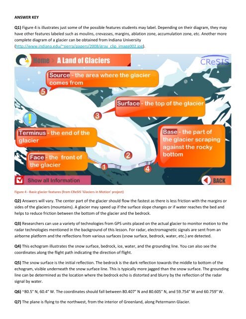
Q1) Figure 4 is illustrates just some of the possible features students may label. Depending on their diagram, they may<br />
have other features labeled such as moulins, crevasses, margins, ablation zone, accumulation zone, etc. Another more<br />
complete diagram of a glacier can be obtained from Indiana University<br />
(http://www.indiana.edu/~sierra/papers/2008/gray_clip_image002.jpg).<br />
Figure 4 - Basic glacier features (from <strong>CReSIS</strong> 'Glaciers in Motion' project)<br />
Q2) Answers will vary. The center part of the glacier should flow the fastest as there is less friction with the margins or<br />
sides of the glaciers (mountains). A glacier may speed up if the surface slope changes or if water reaches the bed and<br />
helps to reduce friction between the bottom of the glacier and the bedrock.<br />
Q3) Researchers can use a variety of technologies from GPS units placed on the actual glacier to monitor motion to the<br />
radar technologies mentioned in the background of this lesson. For radar, electromagnetic signals are sent from an<br />
airborne platform and the reflections from various surfaces (snow surface, bedrock, water, etc.) are detected.<br />
Q4) This echogram illustrates the snow surface, bedrock, ice, water, and the grounding line. You can also see the<br />
coordinates along the flight path indicating the direction of flight.<br />
Q5) The snow surface is the initial reflection. The bedrock is the dark reflection towards the middle to bottom of the<br />
echogram, visible underneath the snow surface line. This is typically more jagged than the snow surface. The grounding<br />
line can be determined as the location where the bedrock echo is distorted and blurry by the reflection of the radar<br />
signal by water.<br />
Q6) ~80.5° N, 60.4° W. The coordinates should fall between 80.407° N and 80.605° N, and 59.754° W and 60.759° W.<br />
Q7) The plane is flying to the northwest, from the interior of Greenland, along Petermann Glacier.