Grounding Line Location using Echograms - CReSIS
Grounding Line Location using Echograms - CReSIS
Grounding Line Location using Echograms - CReSIS

You also want an ePaper? Increase the reach of your titles
YUMPU automatically turns print PDFs into web optimized ePapers that Google loves.
Q10) By plotting the coordinates from the x-axis of the echograms, it is possible to determine the flight path of the<br />
plane. Also, the distance increases from the first set of coordinates to the last set, making it possible to determine flight<br />
direction from simply plotting those two points.<br />
Q11) Answers will vary. Accept all reasonable answers where the student accurately describes the results of their<br />
grounding line estimations compared to the accepted location found by scientists.<br />
Q12) Since the location of the grounding line is a rough indication of the health of a glacier, collecting this data over<br />
multiple years will allow scientists to monitor how a glacier is behaving over time. The results of this data can also lead<br />
to improved models to predict future changes in sea level.<br />
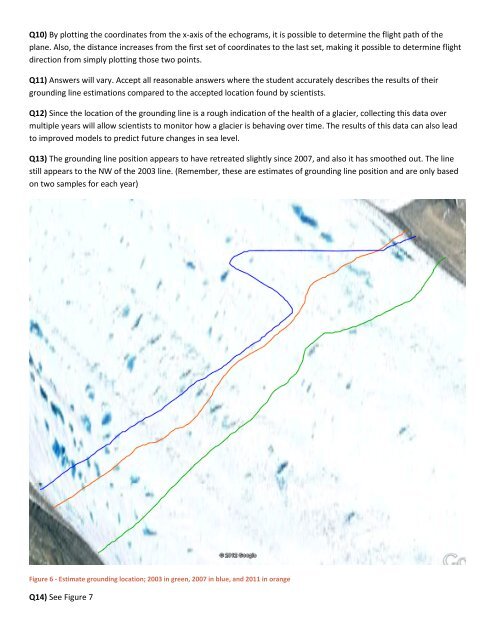
Q13) The grounding line position appears to have retreated slightly since 2007, and also it has smoothed out. The line<br />
still appears to the NW of the 2003 line. (Remember, these are estimates of grounding line position and are only based<br />
on two samples for each year)<br />
Figure 6 - Estimate grounding location; 2003 in green, 2007 in blue, and 2011 in orange<br />
Q14) See Figure 7