Grounding Line Location using Echograms - CReSIS
Grounding Line Location using Echograms - CReSIS
Grounding Line Location using Echograms - CReSIS

Create successful ePaper yourself
Turn your PDF publications into a flip-book with our unique Google optimized e-Paper software.
• Plot the coordinates from the x-axis of the echogram and determine which direction the plane was flying and<br />
record in Table 1. Make sure to carefully label the points from each echogram so as to not confuse them with<br />
other years.<br />
• Repeat for each of the two 2007 images. You should have a total of 28 coordinates plotted.<br />
Table 2 - Fill in coordinates for estimated grounding line locations.<br />
2003 A<br />
2003 B<br />
2007 A<br />
2007 B<br />
Q8) Do the grounding lines fall between the flight lines? If<br />
not recalculate your estimated grounding line<br />
Q9) Briefly describe the changes you observe in the location<br />
of the grounding line in 2003, 2007.<br />
Q10) Briefly explain how you determined the flight direction<br />
for the data collected for each echogram.<br />
Explain:<br />
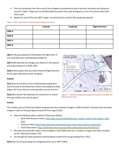
Q11) Does the location of your estimated grounding lines<br />
look the same as the Petermann Glacier <strong>Grounding</strong> <strong>Line</strong> Map<br />
(Figure 3)? If not, what are some possible sources of error?<br />
Q12) Why would it be important for researchers to record<br />
this type of data over several years?<br />
Extend:<br />
Latitude Longitude Flight Direction<br />
The northern part of Petermann Glacier experienced many dramatic changes in 2009 and 2010. Scientists have recorded<br />
images or video of the great glacier break-off from August 2010.<br />
• View the following videos related to Petermann Glacier.<br />
o Byrd Polar Research Center: http://bprc.osu.edu/wiki/Petermann_Glacier_before-after-photos_2010-<br />
2011<br />
o Discovery News: http://news.discovery.com/videos/news-arctic-melt-caught-on-video.html<br />
o Earth Observatory: http://earthobservatory.nasa.gov/NaturalHazards/view.php?id=45112<br />
• Recently processed 2011 data is now available on the <strong>CReSIS</strong> web site. A couple of images have been included<br />
on the ‘Petermann Glacier’ PDF.<br />
• Go through the same processes outlined above to determine the grounding line in 2011.<br />
Q13) How has the grounding line changed position since 2007? 2003?<br />
Figure 3 – Scientists accepted grounding line locations from 2003 and<br />
2007 echogram data.