Grounding Line Location using Echograms - CReSIS
Grounding Line Location using Echograms - CReSIS
Grounding Line Location using Echograms - CReSIS

Create successful ePaper yourself
Turn your PDF publications into a flip-book with our unique Google optimized e-Paper software.
STUDENT PAGE<br />
Lesson Title: Data Series – <strong>Grounding</strong> <strong>Line</strong> <strong>Location</strong> <strong>using</strong> <strong>Echograms</strong><br />
Question: How do scientists use radar track and understand a glacier’s motion over time?<br />
Objectives:<br />
Given a set of data students will be able to:<br />
• Identify grounding lines of a glacier for several years of data<br />
• Plot data that is collected from echograms<br />
• Use latitude and longitude to identify direction<br />
• Understand the reason for the change in grounding lines over time<br />
Vocabulary:<br />
• echogram: __________________________________________________________________________________<br />
• glacier: _____________________________________________________________________________________<br />
• grounding line: _______________________________________________________________________________<br />
• ice sheet: ___________________________________________________________________________________<br />
• Multichannel Coherent Radar Depth Sounder (MCoRDS):<br />
___________________________________________________________________________________________<br />
• outlet glacier: ________________________________________________________________________________<br />
• Radio Detection and Ranging (Radar):<br />
___________________________________________________________________________________________<br />
• remote sensing: ______________________________________________________________________________<br />
o Active sensors _________________________________________________________________________<br />
o Passive sensors ________________________________________________________________________<br />
Background:<br />
Ice sheets, such as those found in Greenland and Antarctica play an<br />
important role in a number of Earth systems. <strong>CReSIS</strong> is especially<br />
interested in their role of changing sea levels. An ice sheet is formed when<br />
large amounts of snow accumulate over time, and under its own weight<br />
begins to compress into ice and spread out over the land. In some cases<br />
this ice is trapped by come geologic features such as a mountain range. In<br />
other cases, this ice is able to flow through breaks in these mountains,<br />
flowing through valleys as glaciers, and eventually reaching the open<br />
water. These are called outlet glaciers, and are the primary way ice from<br />
the interior of an ice sheet reaches the ocean. Through information about<br />
ice thickness and where the ice begins to float as it approaches the ocean<br />
(the grounding line), it is possible gain knowledge about the amount of<br />
water displaced from the ice and its role in sea level changes. <strong>CReSIS</strong> is<br />
generally interested in the ice thickness and location of the grounding line<br />
for the purposes modeling sea level rise. Depending on how much ice<br />
exists and how quickly it is reaching the ocean, it is possible to estimate<br />
how much sea level may change in the future.<br />
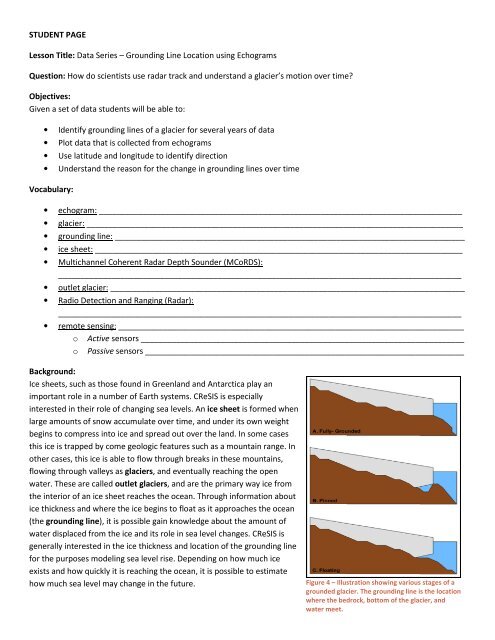
Figure 4 – Illustration showing various stages of a<br />
grounded glacier. The grounding line is the location<br />
where the bedrock, bottom of the glacier, and<br />
water meet.