Mahale Mountains National Park | Summary of Resource Base
Mahale Mountains National Park | Summary of Resource Base
Mahale Mountains National Park | Summary of Resource Base

Create successful ePaper yourself
Turn your PDF publications into a flip-book with our unique Google optimized e-Paper software.
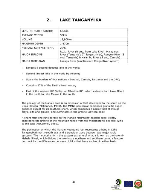
2. LAKE TANGANYIKA<br />
LENGTH (NORTH-SOUTH) 673km<br />
AVERAGE WIDTH 50km<br />
VOLUME 18,900km 3<br />
MAXIMUM DEPTH 1,470m<br />
AVERAGE SURFACE TEMP. 25 o C<br />
Ruzizi River (N end, from Lake Kivu), Malagarasi<br />
MAJOR INFLOWS<br />
River (Tanzania’s 2 nd largest river), Rungwe River (S<br />
end, Tanzania) & Kalambo River (S end, Zambia)<br />
MAJOR OUTFLOWS Lukugu River (empties into Congo River system)<br />
• Longest & second deepest lake in the world;<br />
• Second largest lake in the world by volume;<br />
• Spans the borders <strong>of</strong> four nations - Burundi, Zambia, Tanzania and the DRC;<br />
• Contains 17% <strong>of</strong> the Earth’s fresh water;<br />
• Part <strong>of</strong> the western Rift Valley, or Albertine Rift, which extends from Lake Albert<br />
in the north to Lake Malawi in the south.<br />
The geology <strong>of</strong> the <strong>Mahale</strong> area is an extension <strong>of</strong> that developed to the south on the<br />
Ufipa Plateau (McConnell, 1950). The MMNP peninsular comprises granulitic augengneisses<br />
except for its southern shore, which comprises a narrow belt <strong>of</strong> mbuga<br />
clays, silts and gravels, and culminates in the granite Sibwesa point.<br />
A sharp fault line runs parallel to the <strong>Mahale</strong> <strong>Mountains</strong>’ eastern edge, clearly<br />
separating the granite <strong>of</strong> the mountain range from the metamorphic bed rock lying<br />
to the east (McConnell, 1950).<br />
The peninsular on which the <strong>Mahale</strong> <strong>Mountains</strong> rest represents a bend in Lake<br />
Tanganyika’s north-south axis and a transition zone between two major fault<br />
systems. The mountains form the eastern extreme <strong>of</strong> what is known as the Kalemi-<br />
<strong>Mahale</strong> Shoal, which divides the lake into a northern and southern basin, a feature<br />
born out by the differences between cichlids that have evolved in either basin.<br />
42