OPERATOR'S MANUAL R4 AIS Class A Transponder ... - Polaris-as.dk
OPERATOR'S MANUAL R4 AIS Class A Transponder ... - Polaris-as.dk
OPERATOR'S MANUAL R4 AIS Class A Transponder ... - Polaris-as.dk

You also want an ePaper? Increase the reach of your titles
YUMPU automatically turns print PDFs into web optimized ePapers that Google loves.
Product Description<br />
System Overview<br />
System Overview<br />
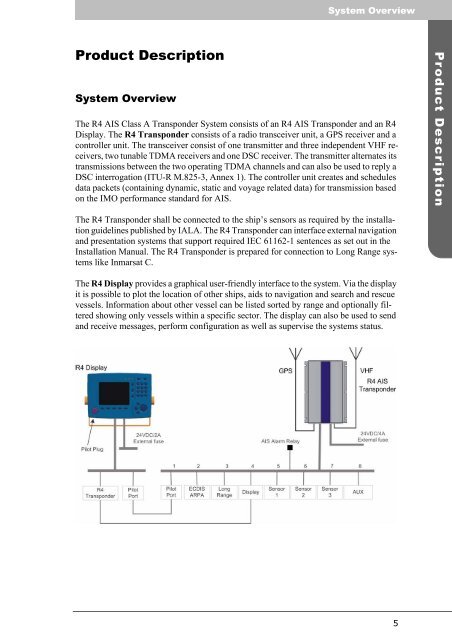
The <strong>R4</strong> <strong>AIS</strong> <strong>Cl<strong>as</strong>s</strong> A <strong>Transponder</strong> System consists of an <strong>R4</strong> <strong>AIS</strong> <strong>Transponder</strong> and an <strong>R4</strong><br />
Display. The <strong>R4</strong> <strong>Transponder</strong> consists of a radio transceiver unit, a GPS receiver and a<br />
controller unit. The transceiver consist of one transmitter and three independent VHF receivers,<br />
two tunable TDMA receivers and one DSC receiver. The transmitter alternates its<br />
transmissions between the two operating TDMA channels and can also be used to reply a<br />
DSC interrogation (ITU-R M.825-3, Annex 1). The controller unit creates and schedules<br />
data packets (containing dynamic, static and voyage related data) for transmission b<strong>as</strong>ed<br />
on the IMO performance standard for <strong>AIS</strong>.<br />
The <strong>R4</strong> <strong>Transponder</strong> shall be connected to the ship’s sensors <strong>as</strong> required by the installation<br />
guidelines published by IALA. The <strong>R4</strong> <strong>Transponder</strong> can interface external navigation<br />
and presentation systems that support required IEC 61162-1 sentences <strong>as</strong> set out in the<br />
Installation Manual. The <strong>R4</strong> <strong>Transponder</strong> is prepared for connection to Long Range systems<br />
like Inmarsat C.<br />
The <strong>R4</strong> Display provides a graphical user-friendly interface to the system. Via the display<br />
it is possible to plot the location of other ships, aids to navigation and search and rescue<br />
vessels. Information about other vessel can be listed sorted by range and optionally filtered<br />
showing only vessels within a specific sector. The display can also be used to send<br />
and receive messages, perform configuration <strong>as</strong> well <strong>as</strong> supervise the systems status.<br />
5<br />
Product Description