Weekly Edition 52 of 2012
Weekly Edition 52 of 2012
Weekly Edition 52 of 2012
Create successful ePaper yourself
Turn your PDF publications into a flip-book with our unique Google optimized e-Paper software.
NP no<br />
Page(s)<br />
Title<br />
IV<br />
4.17<br />
<strong>Weekly</strong><br />
<strong>Edition</strong><br />
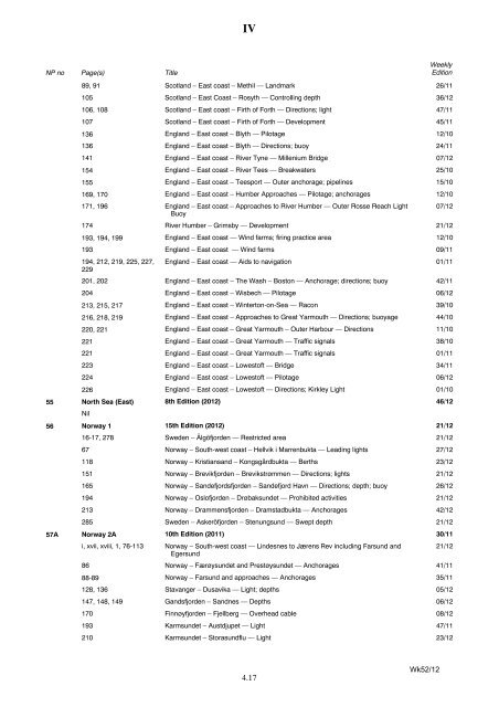
89, 91 Scotland – East coast – Methil — Landmark 26/11<br />
105 Scotland – East Coast – Rosyth — Controlling depth 36/12<br />
106, 108 Scotland – East coast – Firth <strong>of</strong> Forth — Directions; light 47/11<br />
107 Scotland – East coast – Firth <strong>of</strong> Forth — Development 45/11<br />
136 England – East coast – Blyth — Pilotage 12/10<br />
136 England – East coast – Blyth — Directions; buoy 24/11<br />
141 England – East coast – River Tyne — Millenium Bridge 07/12<br />
154 England – East coast – River Tees — Breakwaters 25/10<br />
155 England – East coast – Teesport — Outer anchorage; pipelines 15/10<br />
169, 170 England – East coast – Humber Approaches — Pilotage; anchorages 12/10<br />
171, 196 England – East coast – Approaches to River Humber — Outer Rosse Reach Light<br />
Buoy<br />
07/12<br />
174 River Humber – Grimsby — Development 21/12<br />
193, 194, 199 England – East coast — Wind farms; firing practice area 12/10<br />
193 England – East coast — Wind farms 09/11<br />
194, 212, 219, 225, 227,<br />
229<br />
England – East coast — Aids to navigation 01/11<br />
201, 202 England – East coast – The Wash – Boston — Anchorage; directions; buoy 42/11<br />
204 England – East coast – Wisbech — Pilotage 06/12<br />
213, 215, 217 England – East coast – Winterton-on-Sea — Racon 39/10<br />
216, 218, 219 England – East coast – Approaches to Great Yarmouth — Directions; buoyage 44/10<br />
220, 221 England – East coast – Great Yarmouth – Outer Harbour — Directions 11/10<br />
221 England – East coast – Great Yarmouth — Traffic signals 38/10<br />
221 England – East coast – Great Yarmouth — Traffic signals 01/11<br />
223 England – East coast – Lowest<strong>of</strong>t — Bridge 34/11<br />
224 England – East coast – Lowest<strong>of</strong>t — Pilotage 06/12<br />
226 England – East coast – Lowest<strong>of</strong>t — Directions; Kirkley Light 01/10<br />
55 North Sea (East)<br />
Nil<br />
8th <strong>Edition</strong> (<strong>2012</strong>) 46/12<br />
56 Norway 1 15th <strong>Edition</strong> (<strong>2012</strong>) 21/12<br />
16-17, 278 Sweden – Älgöfjorden — Restricted area 21/12<br />
67 Norway – South-west coast – Hellvik i Marrenbukta — Leading lights 27/12<br />
118 Norway – Kristiansand – Kongsgårdbukta — Berths 23/12<br />
151 Norway – Brevikfjorden – Brevikstrømmen — Directions; lights 21/12<br />
165 Norway – Sandefjordsfjorden – Sandefjord Havn — Directions; depth; buoy 26/12<br />
194 Norway – Osl<strong>of</strong>jorden – Drøbaksundet — Prohibited activities 21/12<br />
213 Norway – Drammensfjorden – Dramstadbukta — Anchorages 42/12<br />
285 Sweden – Askeröfjorden – Stenungsund — Swept depth 21/12<br />
57A Norway 2A 10th <strong>Edition</strong> (2011) 30/11<br />
i, xvii, xviii, 1, 76-113 Norway – South-west coast — Lindesnes to Jærens Rev including Farsund and<br />
Egersund<br />
21/12<br />
86 Norway – Færøysundet and Prestøysundet — Anchorages 41/11<br />
88-89 Norway – Farsund and approaches — Anchorages 35/11<br />
128, 136 Stavanger – Dusavika — Light; depths 05/12<br />
147, 148, 149 Gandsfjorden – Sandnes — Depths 06/12<br />
170 Finnøyfjorden – Fjellberg — Overhead cable 08/12<br />
193 Karmsundet – Austdjupet — Light 47/11<br />
210 Karmsundet – Storasundflu — Light 23/12<br />
Wk<strong>52</strong>/12


