

Weekly Edition 52 of 2012
Weekly Edition 52 of 2012
Weekly Edition 52 of 2012

You also want an ePaper? Increase the reach of your titles
YUMPU automatically turns print PDFs into web optimized ePapers that Google loves.
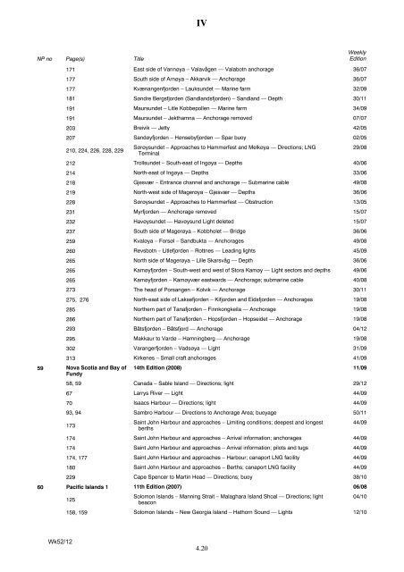
NP no<br />
Page(s)<br />
Title<br />
IV<br />
4.20<br />
<strong>Weekly</strong><br />
<strong>Edition</strong><br />
171 East side <strong>of</strong> Vannøya – Valavågen — Valabotn anchorage 36/07<br />
177 South side <strong>of</strong> Arnøya – Akkarvik — Anchorage 36/07<br />
177 Kvænangenfjorden – Lauksundet — Marine farm 32/09<br />
181 Søndre Bergsfjorden (Sandlandsfjorden) – Sandland — Depth 30/11<br />
191 Maursundet – Litle Kobbepollen — Marine farm 34/09<br />
191 Maursundet – Jekthamna — Anchorage removed 07/07<br />
203 Breivik — Jetty 42/05<br />
207 Sandøyfjorden – Hønsebyfjorden — Spar buoy 02/05<br />
210, 224, 226, 228, 229<br />
Sørøysundet – Approaches to Hammerfest and Melkøya — Directions; LNG<br />
Terminal<br />
212 Trollsundet – South-east <strong>of</strong> Ingøya — Depths 40/06<br />
214 North-east <strong>of</strong> Ingøya — Depths 33/06<br />
218 Gjesvær – Entrance channel and anchorage — Submarine cable 49/08<br />
219 North-west side <strong>of</strong> Magerøya – Gjesvær — Depths 36/06<br />
228 Sørøysundet – Approaches to Hammerfest — Obstruction 13/05<br />
231 Myrfjorden — Anchorage removed 15/07<br />
232 Havøysundet — Havøysund Light deleted 15/07<br />
237 South side <strong>of</strong> Magerøya – Kobbholet — Bridge 36/06<br />
259 Kvaløya – Forsøl – Sandbukta — Anchorages 49/08<br />
260 Revsbotn – Litlefjorden – Rottnes — Leading lights 45/09<br />
265 North side <strong>of</strong> Magerøya – Lille Skarsvåg — Depth 36/06<br />
265 Kamøyfjorden – South-west and west <strong>of</strong> Stora Kamøy — Light sectors and depths 49/06<br />
265 Kamøyfjorden – Kamøyvær eastwards — Anchorage; submarine cable 40/08<br />
273 The head <strong>of</strong> Porsangen – Kolvik — Anchorage 30/11<br />
275, 276 North-east side <strong>of</strong> Laksefjorden – Kifjorden and Eidsfjorden — Anchorages 19/08<br />
285 Northern part <strong>of</strong> Tanafjorden – Finnkongkeila — Anchorage 19/08<br />
286 Northern part <strong>of</strong> Tanafjorden – Hopsfjorden – Hopseidet — Anchorage 19/08<br />
293 Båtsfjorden – Båtsfjord — Anchorage 04/12<br />
295 Makkaur to Vardø – Hamningberg — Anchorage 19/08<br />
302 Varangerfjorden – Vadsøya — Light 31/09<br />
313 Kirkenes – Small craft anchorages 41/09<br />
59 Nova Scotia and Bay <strong>of</strong><br />
Fundy<br />
14th <strong>Edition</strong> (2008) 11/09<br />
58, 59 Canada – Sable Island — Directions; light 29/12<br />
67 Larrys River — Light 44/09<br />
70 Isaacs Harbour — Directions; light 44/09<br />
93, 94 Sambro Harbour — Directions to Anchorage Area; buoyage 50/11<br />
173<br />
Saint John Harbour and approaches – Limiting conditions; deepest and longest<br />
berths<br />
174 Saint John Harbour and approaches – Arrival information; anchorages 44/09<br />
174 Saint John Harbour and approaches – Arrival information; pilots and tugs 44/09<br />
174, 177 Saint John Harbour and approaches – Harbour; canaport LNG facility 44/09<br />
180 Saint John Harbour and approaches – Berths; canaport LNG facility 44/09<br />
229 Cape Spencer to Martin Head — Directions; buoy 38/10<br />
60 Pacific Islands 1 11th <strong>Edition</strong> (2007) 06/08<br />
125<br />
Solomon Islands – Manning Strait – Malaghara Island Shoal — Directions; light<br />
beacon<br />
04/10<br />
Wk<strong>52</strong>/12<br />
158, 159 Solomon Islands – New Georgia Island – Hathorn Sound — Lights 12/10<br />
29/08<br />
44/09


