Weekly Edition 52 of 2012
Weekly Edition 52 of 2012
Weekly Edition 52 of 2012
Create successful ePaper yourself
Turn your PDF publications into a flip-book with our unique Google optimized e-Paper software.
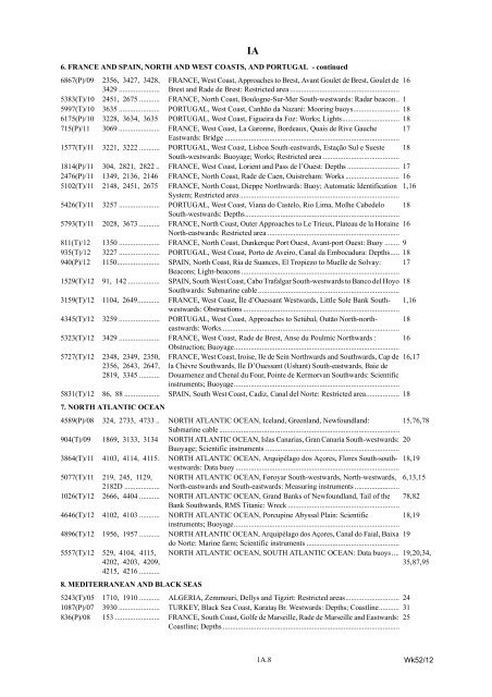
6867(P)/09 2356, 3427, 3428, FRANCE, West Coast, Approaches to Brest, Avant Goulet de Brest, Goulet de 16<br />
3429 ...................... Brest and Rade de Brest: Restricted area ...........................................................<br />
5383(T)/10 2451, 2675 ........... FRANCE, North Coast, Boulogne-Sur-Mer South-westwards: Radar beacon.. 1<br />
5997(T)/10 3635 ...................... PORTUGAL, West Coast, Canhão da Nazaré: Mooring buoys......................... 18<br />
6175(P)/10 3228, 3634, 3635 PORTUGAL, West Coast, Figueira da Foz: Works; Lights............................... 18<br />
715(P)/11 3069 ...................... FRANCE, West Coast, La Garonne, Bordeaux, Quais de Rive Gauche<br />
Eastwards: Bridge ..............................................................................................<br />
17<br />
1577(T)/11 3221, 3222 ........... PORTUGAL, West Coast, Lisboa South-eastwards, Estação Sul e Sueste<br />
South-westwards: Buoyage; Works; Restricted area .........................................<br />
18<br />
1814(P)/11 304, 2821, 2822 .. FRANCE, West Coast, Lorient and Pass de l’Ouest: Depths ............................ 17<br />
2476(P)/11 1349, 2136, 2146 FRANCE, North Coast, Rade de Caen, Ouistreham: Works ............................. 16<br />
5102(T)/11 2148, 2451, 2675 FRANCE, North Coast, Dieppe Northwards: Buoy; Automatic Identification<br />
System; Restricted area ......................................................................................<br />
1, 16<br />
5426(T)/11 3257 ...................... PORTUGAL, West Coast, Viana do Castelo, Rio Lima, Molhe Cabedelo<br />
South-westwards: Depths...................................................................................<br />
18<br />
5793(T)/11 2028, 3673 ........... FRANCE, North Coast, Outer Approaches to Le Trieux, Plateau de la Horaine 16<br />
North-eastwards: Restricted area .......................................................................<br />
811(T)/12 1350 ...................... FRANCE, North Coast, Dunkerque Port Ouest, Avant-port Ouest: Buoy ........ 9<br />
935(T)/12 3227 ...................... PORTUGAL, West Coast, Porto de Aveiro, Canal da Embocadura: Depths..... 18<br />
940(P)/12 1150....................... SPAIN, North Coast, Ria de Suances, El Tropiezo to Muelle de Solvay:<br />
Beacons; Light-beacons .....................................................................................<br />
17<br />
1<strong>52</strong>9(T)/12 91, 142 ................. SPAIN, South West Coast, Cabo Trafalgar South-westwards to Banco del Hoyo 18<br />
Southwards: Submarine cable ............................................................................<br />
3159(T)/12 1104, 2649............ FRANCE, West Coast, Île d’Ouessant Westwards, Little Sole Bank Southwestwards:<br />
Obstructions ....................................................................................<br />
1, 16<br />
4345(T)/12 3259 ...................... PORTUGAL, West Coast, Approaches to Setúbal, Outăo North-northeastwards:<br />
Works................................................................................................<br />
18<br />
5323(T)/12 3429 ...................... FRANCE, West Coast, Rade de Brest, Anse du Poulmic Northwards :<br />
Obstruction; Buoyage.........................................................................................<br />
16<br />
5727(T)/12 2348, 2349, 2350, FRANCE, West Coast, Iroise, Ile de Sein Northwards and Southwards, Cap de 16, 17<br />
2356, 2643, 2647, la Chèvre Southwards, Ile D’Ouessant (Ushant) South-eastwards, Baie de<br />
2819, 3345 ........... Douarnenez and Chenal du Four, Pointe de Kermorvan Southwards: Scientific<br />
instruments; Buoyage.........................................................................................<br />
5831(T)/12 86, 88 ................... SPAIN, South West Coast, Cadiz, Canal del Norte: Restricted area.................. 18<br />
7. NORTH ATLANTIC OCEAN<br />
4589(P)/08 324, 2733, 4733 .. NORTH ATLANTIC OCEAN, Iceland, Greenland, Newfoundland:<br />
Submarine cable .................................................................................................<br />
15, 76, 78<br />
904(T)/09 1869, 3133, 3134 NORTH ATLANTIC OCEAN, Islas Canarias, Gran Canaria South-westwards: 20<br />
Buoyage; Scientific instruments ........................................................................<br />
3864(T)/11 4103, 4114, 4115. NORTH ATLANTIC OCEAN, Arquipélago dos Açores, Flores South-southwestwards:<br />
Data buoy ........................................................................................<br />
18, 19<br />
5077(T)/11 219, 245, 1129, NORTH ATLANTIC OCEAN, Føroyar South-westwards, North-westwards, 6, 13, 15<br />
2182D ................... North-eastwards and South-eastwards: Measuring instruments ........................<br />
1026(T)/12 2666, 4404 ........... NORTH ATLANTIC OCEAN, Grand Banks <strong>of</strong> Newfoundland, Tail <strong>of</strong> the<br />
Bank Southwards, RMS Titanic: Wreck ............................................................<br />
78, 82<br />
4646(T)/12 4102, 4103 ........... NORTH ATLANTIC OCEAN, Porcupine Abyssal Plain: Scientific<br />
instruments; Buoyage.........................................................................................<br />
18, 19<br />
4896(T)/12 1956, 1957 ........... NORTH ATLANTIC OCEAN, Arquipélago dos Açores, Canal do Faial, Baixa 19<br />
do Norte: Marine farm; Scientific instruments ..................................................<br />
5557(T)/12 <strong>52</strong>9, 4104, 4115, NORTH ATLANTIC OCEAN, SOUTH ATLANTIC OCEAN: Data buoys .... 19, 20, 34,<br />
4202, 4203, 4209,<br />
4215, 4216 ...........<br />
35, 87, 95<br />
8. MEDITERRANEAN AND BLACK SEAS<br />
<strong>52</strong>43(T)/05 1710, 1910 ........... ALGERIA, Zemmouri, Dellys and Tigzirt: Restricted areas............................. 24<br />
1087(P)/07 3930 ...................... TURKEY, Black Sea Coast, Karataş Br. Westwards: Depths; Coastline........... 31<br />
836(P)/08 153 ........................ FRANCE, South Coast, Golfe de Marseille, Rade de Marseille and Eastwards: 25<br />
Coastline; Depths ...............................................................................................<br />
IA<br />
6. FRANCE AND SPAIN, NORTH AND WEST COASTS, AND PORTUGAL - continued<br />
1A.8<br />
Wk<strong>52</strong>/12


